
Surf Forecasts:

The Reef surf forecast from 1 Aug 2026:
- Best quality surf: Saturday 1 Aug, 7AM (local time) - 2.5ft (0.7m), 9s period, W swell with cross-offshore winds.
- Most powerful swell: Monday 3 Aug, 4PM (local time) - 3.5ft (1.1m), 8s period, W swell with 173 kJ wave energy.
- Next surfable swell (1★+): Saturday 1 Aug, 7AM (local time) - 2.5ft (0.7m), 9s period with W swell.
Best Forecast Surf Conditions for The Reef this week:
The surf forecast for The Reef over the next 16 days: The first swell (rated 1 star or higher) is forecast to arrive on Saturday (Aug 01) at 7AM. The primary swell is predicted to be 0.7m and 9s period with a secondary swell of 0.9m and 6s. The wind is predicted to be cross-offshore as the swell arrives.
The most powerful waves expected at The Reef in the next 16 days are 1.1m 8s and forecast to arrive on Monday (Aug 03) at 4PM. Winds are predicted to be cross-onshore at the time the swell arrives.
| Wave Type | Time (WEST) & Date | Wave Height & Period |
|---|---|---|
| Next good surf (1 star+) | 7AM (Sat 1st Aug) | 2.5ft (0.7m) 9s |
| Best Surf | 7AM (Sat 1st Aug) | 2.5ft (0.7m) 9s |
| Most Powerful | 4PM (Mon 3rd Aug) | 3.5ft (1.1m) 8s |
Table - best surf conditions forecast for The Reef over the next 16 days.
The Lowdown
Alright, Rusty here. Let’s get into it.
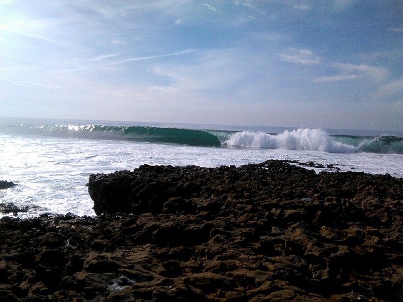
First off, I’ve gotta be straight with you – this is a tough one. The Reef is our only game in town for the next 16 days, and to be honest, it’s looking bleak. The pattern is pretty much the same from Friday, July 31st, all the way through to Saturday, August 15th. We’ve got a wave coming in, but the wind is a constant pain in the arse. It’s almost always cross or cross-onshore, with a lot of moderate to fresh breezes, so the surface is going to be chopped up or lumpy the whole time.
The water temp at the start is 68°, which is bang on average for this time of year, so a wetsuit is fine.
Now, for the detail. It kicks off on Friday the 31st of July and the first week is a write-off. The swell is small, mostly under 3 feet, and the wind is a problem. The energy is weak to moderate – we’re talking values like 61 (combined energy) on Friday, building to maybe 169 by Saturday morning. But it doesn’t matter because the wind is ruining it. The forecasters are calling it “poor surf conditions” every single day until the 10th of August. The waves are there, but they’re just messy.
There’s a bit of a pulse on the 8th of August, with swell hitting 4 feet from the WNW with a period of 10 seconds, and the energy jumps to 324 (moderate). But again, the wind is cross or cross-on, so it’s going to be a bumpy, frustrating session. The Reef is an advanced reef break, and it’s fairly consistent, but with this wind, it’s just not gonna be fun.
The real stand-out – and I say this with a heavy heart because it’s still not perfect – is the morning of Monday, August 10th. The swell is 7 feet from the NNW, with a period of 8 seconds. The energy is strong at 450 (combined energy). The wind is cross-shore from the NNW at 15 km/h (9 mph), with a gentle breeze. That’s the best wind we see in the whole run. The problem is that the swell is big for this spot, over 5 feet, so it’s not for beginners. For the advanced crew, it could offer some size, but the short period of 8 seconds means it’ll be a bit soft and lumpy on the takeoff. It’s the only day that even gets a “marginal” call. It’s the best of a bad bunch.
After that, it drops back down. The 11th and 12th of August have 4 feet waves from the W with a 10-second period and energy around 314-318 (moderate), but the wind picks up again, with fresh breezes from the N or NNW. It’s the same story: cross-shore, lumpy, poor.
The last few days, from the 13th to the 15th, are just a repeat of the first week. Small swell, poor wind, and the energy drops to weak levels (98 on the 15th). Honestly, there’s no day in this 16-day window that I’d get excited about.
So, the bottom line? For a spot that’s fairly consistent, it’s a rare blank run. The wind is just not cooperating. It’s a surf outlook that’s more interesting for a kite session than a paddle, given the strong cross-shore winds. The forecasts can change, but as it stands, I’d give this one a miss and wait for the next system.
Rusty.
Short Range ForecastMostly dry. Warm (max 22°C on Sat morning, min 18°C on Fri night). Wind will be generally light. | Days 4-6 Weather SummaryMostly dry. Warm (max 23°C on Tue morning, min 18°C on Wed night). Wind will be generally light. | ||||||||||||||||||||
Saturday 1 | Sunday 2 | Monday 3 | Tuesday 4 | Wednesday 5 | Thursday 6 | Friday 7 | |||||||||||||||
AM | PM | Night | AM | PM | Night | AM | PM | Night | AM | PM | Night | AM | PM | Night | AM | PM | Night | AM | PM | Night | |
Swell Height Map |  |  |  |  |  |  |  | ||||||||||||||
Wave Height (m) Direction Period (s) | W 9 | W 9 | NNW 6 | NNW 6 | W 10 | W 10 | W 9 | W 8 | WNW 9 | WNW 9 | WNW 8 | WNW 8 | WNW 8 | W 8 | W 10 | NNW 8 | NNW 8 | NNW 9 | W 9 | WNW 8 | W 8 |
Wave Graph | |||||||||||||||||||||
78 | 73 | 79 | 58 | 70 | 67 | 59 | 173 | 82 | 129 | 94 | 90 | 81 | 72 | 52 | 61 | 105 | 84 | 42 | 70 | 117 | |
Wind (km/h) | |||||||||||||||||||||
Wind State on-shore cross-onshore cross-shore cross-offshore off-shore glassy | cross | cross-on | cross | cross-on | cross-on | cross-on | cross-on | cross-on | cross-on | cross-on | cross-on | cross | cross | cross-on | cross | cross | cross | cross | cross-on | cross-on | cross-on |
High Tide | 5:06AM2.63m | 5:19PM2.89m | 5:39AM2.62m | 5:53PM2.84m | 6:15AM2.58m | 6:29PM2.74m | 6:54AM2.52m | 7:11PM2.61m | 7:40AM2.43m | 8:02PM2.45m | 8:38AM2.33m | 9:08PM2.30m | 9:51AM2.28m | 10:33PM2.23m | |||||||
Low Tide | 11:03AM0.32m | 11:32PM0.26m | 11:37AM0.35m | 00:06AM0.30m | 12:13PM0.42m | 00:43AM0.38m | 12:54PM0.52m | 1:25AM0.50m | 1:43PM0.64m | 2:17AM0.64m | 2:47PM0.76m | 3:24AM0.77m | 4:09PM0.82m | ||||||||
6:37 | — | — | 6:37 | — | — | 6:39 | — | — | 6:39 | — | — | 6:41 | — | — | 6:41 | — | — | 6:43 | — | — | |
— | 8:49 | — | — | 8:47 | — | — | 8:46 | — | — | 8:45 | — | — | 8:45 | — | — | 8:44 | — | — | 8:43 | — | |
mm | — | — | — | — | — | — | — | — | — | — | — | — | — | — | — | — | — | — | — | — | — |
Temp °C | 22 | 21 | 19 | 21 | 21 | 20 | 22 | 22 | 22 | 23 | 23 | 21 | 21 | 21 | 19 | 22 | 22 | 20 | 22 | 22 | 21 |
Feels °C | 21 | 19 | 17 | 20 | 20 | 20 | 22 | 22 | 23 | 23 | 23 | 22 | 21 | 19 | 17 | 19 | 19 | 18 | 21 | 22 | 22 |
Swell 1 Height (m) Direction Period (s) | W 9 | W 9 | W 9 | W 9 | W 10 | W 10 | W 9 | NNW 7 | W 7 | WNW 9 | WNW 8 | WNW 8 | WNW 8 | W 8 | NNW 8 | NNW 8 | W 10 | NNW 9 | NNW 8 | WNW 8 | W 8 |
78 | 73 | 78 | 57 | 70 | 67 | 59 | 5 | 56 | 129 | 94 | 90 | 81 | 72 | 47 | 61 | 70 | 84 | 38 | 70 | 117 | |
Swell 2 Height (m) Direction Period (s) | NNW 10 | NNW 9 | NNW 8 | N 8 | NNW 8 | NNW 6 | NNW 7 | — | WNW 9 | NNW 8 | NNW 11 | NNW 10 | NNW 9 | NNW 9 | W 7 | W 10 | NNW 10 | W 10 | W 9 | NNW 8 | NNW 8 |
20 | 26 | 37 | 29 | 19 | 12 | 10 | — | 82 | 6 | 12 | 38 | 47 | 49 | 26 | 50 | 10 | 47 | 42 | 36 | 19 | |
Swell 3 Height (m) Direction Period (s) | NNW 8 | — | — | W 8 | — | NNW 7 | NNW 5 | S 14 | N 8 | S 13 | N 7 | SW 12 | WNW 10 | SW 12 | W 10 | WNW 6 | S 12 | SW 13 | S 13 | S 12 | SW 12 |
7 | — | — | 1 | — | 10 | 2 | 4 | 5 | 3 | 1 | 6 | 10 | 6 | 52 | 13 | 3 | 7 | 3 | 3 | 6 | |
Wind waves Height (m) Direction Period (s) | NNW 6 | NNW 6 | NNW 6 | NNW 6 | NNW 6 | — | — | W 8 | — | — | — | — | — | NNW 3 | NNW 4 | NNW 4 | NNW 8 | — | — | WSW 2 | — |
61 | 70 | 79 | 58 | 42 | — | — | 173 | — | — | — | — | — | 4 | 16 | 13 | 105 | — | — | 1 | — | |
Nearest Offshore or Glassy | |||||||||||||||||||||
Distance (km) | 26 | 30 | 27 | 44 | 411 | 26 | 3 | 406 | 26 | 26 | 215 | 29 | 26 | 406 | 26 | 236 | 411 | 27 | 44 | 403 | 38 |
Best forecast wave conditions in Ericeira | |||||||||||||||||||||
Best forecast wave conditions in Portugal | |||||||||||||||||||||
Header Global | |||||||||||||||||||||
- Map Icons:
 Break
Break Live Wave Height (m)
 Live Wind Speed (km/h)
 Surf Rating (10 Max)
 Ocean Swells (m)
- Wind Speed (km/h)
Latest Updates


FREE! Surf-Forecast.com widget for your website
The surf report / weather widget below is available to embed on third party websites free of charge and provides a summary of our The Reef surf forecast. Simply grab the html code snippet that we provide and paste it into your own site. You can choose your preferred language and metric/imperial units for the surf forecast feed to suit users of your site. Click here to get the code.
Information about the The Reef Surf forecast
The above surf forecast table for The Reef provides essential information for determining whether the surfing conditions will be good over the next 16 days. A general guide to surfing at The Reef can be found by selecting the local surf guide option on the grey menu. Our The Reef surf forecast is unique since it includes wave energy (power) that defines the real feel of the surf rather than just the height or the period. If you surf the same spot (The Reef) regularly then make a mental note of the wave energy from the surf forecast table each time you go. Very soon you may start to choose your surf days based on the wave energy alone combined with our forecast of favourable offshore wind conditions. Our star ratings will help here and of course you will also find the usual wave height and period predictions on our surf forecasts as well as a full break down of the swell components under our advanced users option (to reveal that, click the little Einstein character under the tide times).
Further information to help with frequently asked questions about our surf forecast for The Reef may be found under the help tab on the top menu and also by moving your mouse over the question marks on the surf forecast table itself. Please always bear in mind that the forecast is for near-shore open water and local factors at each surf break influence the actual breaking wave height, such as the beach / reef profile, water depths offshore and shelter.
The Reef is 15 km (9 miles) from the city of Sintra. If you plan a holiday in Ericeira, look for hotels and other accommodation in Sintra. Sintra has rooms for a wide range of budgets as well as car hire and transport links.
 Nearest