

Surf Forecasts:

Magic Lands surf forecast from 2 Aug 2026:
- Best quality surf: Monday 10 Aug, 10AM (local time) - 20ft (6.0m), 14s period, WSW swell with cross-shore winds.
- Most powerful swell: Monday 10 Aug, 10AM (local time) - 20ft (6.0m), 14s period, WSW swell with 13,955 kJ wave energy.
- Next surfable swell (1★+): Friday 7 Aug, 4PM (local time) - 6ft (1.8m), 15s period with WSW swell.
Best Forecast Surf Conditions for Magic Lands this week:
The surf forecast for Magic Lands over the next 16 days: The first swell (rated 1 star or higher) is forecast to arrive on Friday (Aug 07) at 4PM. The primary swell is predicted to be 1.8m and 15s period with a secondary swell of 0.7m and 19s. The wind is predicted to be glassy as the swell arrives.
The most powerful waves expected at Magic Lands in the next 16 days are 6.0m 14s and forecast to arrive on Monday (Aug 10) at 10AM. Winds are predicted to be cross-shore at the time the swell arrives. The largest open ocean swell (not directed at the beach) is 3.0m 7s period and expected on Monday (Aug 10) at 1AM.
| Wave Type | Time (AEST) & Date | Wave Height & Period |
|---|---|---|
| Next good surf (1 star+) | 4PM (Fri 7th Aug) | 6ft (1.8m) 15s |
| Best Surf | 10AM (Mon 10th Aug) | 20ft (6.0m) 14s |
| Most Powerful | 10AM (Mon 10th Aug) | 20ft (6.0m) 14s |
Table - best surf conditions forecast for Magic Lands over the next 16 days.
The Lowdown
Alright, Rusty here again, giving you the rundown in feet and miles.
The water temperature is sitting at 56°F, with an anomaly of about 1°F, which is pretty much average for the time of year.
We’re looking at a rough patch to start. The first few days are a total loss – fresh cross-shore winds and lumpy, choppy surf. The swell energy is moderate, around 1800 on Monday, but the wind kills it. Tuesday stays messy, and Wednesday drops to a weak 682 with onshore winds. Thursday and Friday are small and choppy. Not much to work with.
But then, Friday, August 7th afternoon, it all comes together. The wind goes glassy at 5 km/h from the WNW, and we’ve got a 6-foot SW groundswell with a very long 15-second period. The combined energy hits 1860 (moderate wave energy), and the conditions are glassy. This is the standout. That long period groundswell will be peeling nicely at Magic Lands, which is sheltered and handles that SW direction well. This is the best session in the whole forecast.
Saturday morning, August 8th, is still decent with a clean 5-foot WSW swell and 16-second period, though the wind picks up to a cross-off 20 km/h. The energy is 1321 (moderate). It’s a solid follow-up, but not as perfect as Friday afternoon.
After that, the wind gets nasty again from Sunday, with a near gale blowing 50 km/h, and the swell drops. The next real standout looks to be Tuesday, August 18th morning, with a clean 7-foot WSW swell, 11-second period, cross-off wind, and energy around 1437 (moderate wave energy). That’s a long way out, so treat it as promising but not locked in.
There’s also a huge swell event on Monday, August 10th, with 20-foot WSW swell and energy readings over 13,000 (very strong). That’s way too big for Magic Lands, and only for experts.
So, the call: if you want the best, be there Friday afternoon, August 7th, for that glassy, long-period groundswell. Saturday morning is a good backup. Everything else is either blown out, too small, or too big. The second week has a promising look on Tuesday, August 18th, but it’s still a long shot.
Rusty out.
Short Range ForecastHeavy rain (total 33mm), heaviest during Tue morning. Very mild (max 12°C on Mon afternoon, min 8°C on Mon night). Winds decreasing (fresh winds from the WNW on Mon night, light winds from the SSW by Tue night). | Days 4-6 Weather SummaryLight rain (total 4mm), mostly falling on Thu night. Very mild (max 15°C on Sat afternoon, min 9°C on Thu morning). Winds increasing (calm on Fri afternoon, strong winds from the NNW by Sat night). | ||||||||||||||||||||
Monday 3 | Tuesday 4 | Wednesday 5 | Thursday 6 | Friday 7 | Saturday 8 | Sunday 9 | |||||||||||||||
AM | PM | Night | AM | PM | Night | AM | PM | Night | AM | PM | Night | AM | PM | Night | AM | PM | Night | AM | PM | Night | |
Swell Height Map |  |  |  | 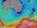 | 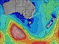 | 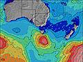 | 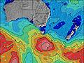 | ||||||||||||||
Wave Height (m) Direction Period (s) | SW 15 | WSW 15 | WSW 13 | WSW 11 | WSW 11 | WSW 10 | SW 9 | SW 14 | SW 13 | SW 12 | SW 16 | WSW 18 | WSW 16 | WSW 15 | WSW 17 | WSW 16 | WSW 16 | WSW 14 | WSW 14 | WSW 16 | WSW 14 |
Wave Graph | |||||||||||||||||||||
893 | 760 | 2313 | 773 | 1708 | 684 | 334 | 305 | 245 | 149 | 196 | 418 | 1273 | 1447 | 1932 | 1321 | 1126 | 701 | 649 | 402 | 796 | |
Wind (km/h) | |||||||||||||||||||||
Wind State on-shore cross-onshore cross-shore cross-offshore off-shore glassy | cross | cross-on | cross-on | cross | on | on | on | cross-on | cross-on | cross | cross | cross | cross-on | glassy | off | cross-off | cross-off | cross-off | cross-off | cross-off | on |
High Tide | 3:04PM2.16m | 3:20AM1.96m | 3:34PM2.17m | 4:02AM2.03m | 4:04PM2.17m | 4:44AM2.08m | 4:36PM2.16m | 5:29AM2.10m | 5:12PM2.14m | 6:19AM2.09m | 5:52PM2.10m | 7:15AM2.05m | 6:39PM2.05m | ||||||||
Low Tide | 9:20PM0.51m | 9:20AM0.49m | 9:53PM0.39m | 9:58AM0.54m | 10:27PM0.28m | 10:37AM0.61m | 11:04PM0.19m | 11:19AM0.70m | 11:45PM0.13m | 12:04PM0.81m | 00:33AM0.11m | 12:56PM0.92m | 1:28AM0.13m | ||||||||
7:18 | — | — | 7:18 | — | — | 7:16 | — | — | 7:16 | — | — | 7:15 | — | — | 7:13 | — | — | 7:11 | — | — | |
— | 5:30 | — | — | 5:30 | — | — | 5:31 | — | — | 5:32 | — | — | 5:34 | — | — | 5:35 | — | — | 5:36 | — | |
mm | 1 | — | 4 | 10 | 5 | 10 | 2 | 1 | — | — | — | 1 | — | — | — | — | — | 3 | 1 | 2 | 8 |
Temp °C | 11 | 12 | 10 | 10 | 12 | 11 | 12 | 12 | 12 | 9 | 10 | 11 | 12 | 13 | 13 | 14 | 15 | 14 | 11 | 10 | 12 |
Feels °C | 4 | 5 | 3 | 6 | 5 | 6 | 7 | 7 | 6 | 4 | 4 | 5 | 8 | 11 | 9 | 9 | 10 | 7 | 0 | 2 | 2 |
Swell 1 Height (m) Direction Period (s) | SW 15 | WSW 15 | SSW 18 | WSW 11 | — | WSW 10 | WSW 11 | SW 14 | SW 13 | SW 5 | SW 16 | WSW 18 | WSW 16 | WSW 15 | WSW 17 | WSW 16 | WSW 16 | WSW 14 | WSW 14 | WSW 16 | WSW 14 |
893 | 760 | 30 | 773 | — | 684 | 70 | 305 | 245 | 43 | 196 | 418 | 1273 | 1447 | 1932 | 1321 | 1126 | 701 | 649 | 402 | 796 | |
Swell 2 Height (m) Direction Period (s) | SW 17 | — | — | WSW 13 | — | SW 21 | SW 20 | SW 19 | WSW 18 | SW 12 | WSW 12 | SW 15 | WSW 6 | SW 19 | SW 18 | — | SSW 8 | — | WSW 18 | E 8 | WSW 21 |
302 | — | — | 451 | — | 111 | 186 | 175 | 123 | 149 | 91 | 220 | 55 | 376 | 80 | — | 6 | — | 124 | 1 | 291 | |
Swell 3 Height (m) Direction Period (s) | — | — | — | — | — | SW 20 | SW 14 | SSW 19 | SSW 18 | SW 16 | SSW 5 | WSW 14 | S 4 | SSW 20 | SSW 5 | — | — | — | WSW 18 | — | SW 21 |
— | — | — | — | — | 15 | 92 | 36 | 30 | 127 | 8 | 82 | 10 | 37 | 4 | — | — | — | 180 | — | 17 | |
Wind waves Height (m) Direction Period (s) | W 10 | W 8 | WSW 13 | NW 4 | WSW 11 | — | SW 9 | SW 8 | SW 6 | NW 3 | WNW 4 | WSW 11 | WSW 9 | — | — | NNW 4 | NNW 4 | N 5 | NNW 6 | WNW 13 | WNW 7 |
605 | 573 | 2313 | 28 | 1708 | — | 334 | 226 | 108 | 6 | 15 | 407 | 222 | — | — | 13 | 9 | 61 | 380 | 1538 | 772 | |
Nearest Offshore or Glassy | |||||||||||||||||||||
Distance (km) | 102 | 88 | 88 | 5 | 31 | 31 | 20 | 92 | 28 | 5 | 5 | 26 | 15 | 0 | 0 | 7 | 5 | 9 | 243 | 94 | 92 |
Best forecast wave conditions in Phillip Island | |||||||||||||||||||||
Best forecast wave conditions in Australia | |||||||||||||||||||||
Header Global | |||||||||||||||||||||
- Map Icons:
 Break
Break Live Wave Height (m)
 Live Wind Speed (km/h)
 Surf Rating (10 Max)
 Ocean Swells (m)
- Wind Speed (km/h)
Latest Updates


FREE! Surf-Forecast.com widget for your website
The surf report / weather widget below is available to embed on third party websites free of charge and provides a summary of our Magic Lands surf forecast. Simply grab the html code snippet that we provide and paste it into your own site. You can choose your preferred language and metric/imperial units for the surf forecast feed to suit users of your site. Click here to get the code.
Information about the Magic Lands Surf forecast
The above surf forecast table for Magic Lands provides essential information for determining whether the surfing conditions will be good over the next 16 days. A general guide to surfing at Magic Lands can be found by selecting the local surf guide option on the grey menu. Our Magic Lands surf forecast is unique since it includes wave energy (power) that defines the real feel of the surf rather than just the height or the period. If you surf the same spot (Magic Lands) regularly then make a mental note of the wave energy from the surf forecast table each time you go. Very soon you may start to choose your surf days based on the wave energy alone combined with our forecast of favourable offshore wind conditions. Our star ratings will help here and of course you will also find the usual wave height and period predictions on our surf forecasts as well as a full break down of the swell components under our advanced users option (to reveal that, click the little Einstein character under the tide times).
Further information to help with frequently asked questions about our surf forecast for Magic Lands may be found under the help tab on the top menu and also by moving your mouse over the question marks on the surf forecast table itself. Please always bear in mind that the forecast is for near-shore open water and local factors at each surf break influence the actual breaking wave height, such as the beach / reef profile, water depths offshore and shelter.
Magic Lands is 47 km (29 miles) from Mornington. If you plan a holiday in Phillip Island, look for hotels and other accommodation in Mornington. Mornington has rooms for a wide range of budgets as well as car hire and transport links.
 Nearest