

Surf Forecasts:

Golden Bay surf forecast from 16 Jul 2026:
- Most powerful swell: Sunday 19 Jul, 2AM (local time) - 2.5ft (0.8m), 5s period, NW swell with 30 kJ wave energy.
Best Forecast Surf Conditions for Golden Bay this week:
The most powerful waves expected at Golden Bay in the next 16 days are 0.8m 5s and forecast to arrive on Sunday (Jul 19) at 2AM. Winds are predicted to be cross-onshore at the time the swell arrives. The largest open ocean swell (not directed at the beach) is 0.2m 3s period and expected on Thursday (Jul 23) at 8AM.
| Wave Type | Time (CEST) & Date | Wave Height & Period |
|---|---|---|
| Next good surf (1 star+) | - | - |
| Best Surf | - | - |
| Most Powerful | 2AM (Sun 19th Jul) | 2.5ft (0.8m) 5s |
Table - best surf conditions forecast for Golden Bay over the next 16 days.
The Lowdown
Alright folks, Rusty here. Let’s be straight with you about Golden Bay. Looking at this 16-day window, I’ve got to tell you, it’s a tough stretch. The data shows a long, dry spell with very little to get excited about. We’re talking about a gap of nearly two weeks where the surf just isn’t offering anything worthwhile. The first few days are flat, and when a bit of swell does show up, the wind is usually wrecking it. It’s not a total write-off, but you’ll need to be patient and pick your moments.
The first real chance comes on the morning of Thursday the 24th of July. A new swell tries to push in, but it's met with a near gale cross-onshore wind at 31 mph. The wave height is around 7 ft from the WNW, but the conditions are blown out. The combined energy is moderate at 350, but it’s just not surfable for a paddle. This setup is far more interesting for kite surfing than paddle surfing. It stays messy and onshore into the afternoon with a bigger 8 ft swell and 562 energy.
The best looking option, and really the only standout, comes on the morning of Friday the 25th of July. The wind swings to a fresh cross-shore from the NNW at 22 mph, and the swell drops to a more manageable 4 ft from the NW. The energy is moderate at 118. It’s not perfect, but it’s the cleanest of a messy bunch. The water temp is a touch warmer than normal at 80°.
The rest of the run is a mix of small, weak swells and onshore wind. The morning of Tuesday the 28th of July sees a clean offshore breeze from the East at 19 mph, but there’s no swell at all. The same goes for the morning of the 29th of July, with a glassy flat spell. It’s a frustrating outlook for the area, but it tends not to stay poor for long, and forecasts can change.
Rusty.
Short Range ForecastMostly dry. Warm (max 33°C on Sun morning, min 27°C on Thu night). Wind will be generally light. | Days 5-7 Weather SummaryMostly dry. Warm (max 33°C on Sun afternoon, min 26°C on Wed morning). Wind will be generally light. | |||||||||||||||||||
Thu 16 | Friday 17 | Saturday 18 | Sunday 19 | Monday 20 | Tuesday 21 | Wednesday 22 | ||||||||||||||
PM | Night | AM | PM | Night | AM | PM | Night | AM | PM | Night | AM | PM | Night | AM | PM | Night | AM | PM | Night | |
Swell Height Map | 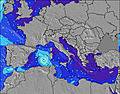 | 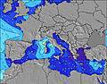 | 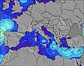 | 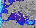 | 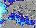 | 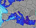 | 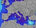 | |||||||||||||
Wave Height (m) Direction Period (s) | WNW 5 | WNW 4 | WNW 4 | WNW 4 | WNW 3 | NW 3 | NW 4 | NW 5 | WNW 5 | NW 4 | NW 5 | NW 4 | NW 4 | NW 4 | WNW 4 | NW 4 | WNW 4 | NW 5 | WNW 5 | NW 5 |
Wave Graph | ||||||||||||||||||||
2 | 3 | 1 | 1 | 1 | 6 | 10 | 30 | 15 | 10 | 22 | 20 | 6 | 4 | 7 | 3 | 10 | 25 | 28 | 28 | |
Wind (km/h) | ||||||||||||||||||||
Wind State on-shore cross-onshore cross-shore cross-offshore off-shore glassy | cross-off | cross | glassy | glassy | on | cross-on | on | cross-on | cross-on | cross-on | on | cross-on | glassy | on | on | on | on | cross-on | on | cross-on |
High Tide | 5:35PM0.20m | 5:43AM0.18m | 6:06PM0.18m | 6:19AM0.18m | 6:34PM0.17m | 6:56AM0.16m | 7:02PM0.15m | 7:38AM0.15m | 7:31PM0.14m | 8:31AM0.14m | 8:10PM0.12m | 10:09AM0.13m | 9:35PM0.11m | |||||||
Low Tide | 11:43PM0.02m | 11:52AM0.01m | 00:13AM0.02m | 12:27PM0.03m | 00:44AM0.03m | 1:02PM0.05m | 1:16AM0.04m | 1:40PM0.07m | 1:53AM0.05m | 2:31PM0.08m | 2:47AM0.07m | 4:37PM0.10m | 4:48AM0.07m | |||||||
— | — | 5:58 | — | — | 5:58 | — | — | 5:58 | — | — | 6:00 | — | — | 6:01 | — | — | 6:01 | — | — | |
8:19 | — | — | 8:17 | — | — | 8:17 | — | — | 8:16 | — | — | 8:15 | — | — | 8:15 | — | — | 8:15 | — | |
mm | — | — | — | — | — | — | — | — | — | — | — | — | — | — | — | — | — | — | — | — |
Temp °C | 28 | 28 | 28 | 30 | 30 | 29 | 29 | 30 | 33 | 33 | 30 | 32 | 32 | 32 | 33 | 33 | 30 | 27 | 27 | 27 |
Feels °C | 30 | 29 | 31 | 31 | 32 | 29 | 30 | 32 | 33 | 33 | 31 | 32 | 33 | 30 | 31 | 30 | 30 | 27 | 29 | 29 |
Swell 1 Height (m) Direction Period (s) | WSW 4 | WNW 4 | WNW 4 | WNW 4 | — | E 7 | NE 6 | NE 5 | — | NE 4 | — | — | — | — | NW 4 | NW 4 | — | — | — | NW 5 |
1 | 3 | 1 | 1 | — | 1 | 1 | 1 | — | 1 | — | — | — | — | 3 | 3 | — | — | — | 28 | |
Swell 2 Height (m) Direction Period (s) | WNW 5 | — | — | — | — | — | — | NE 5 | — | — | — | — | — | — | — | — | — | — | — | NE 5 |
2 | — | — | — | — | — | — | 1 | — | — | — | — | — | — | — | — | — | — | — | 1 | |
Swell 3 Height (m) Direction Period (s) | E 6 | — | — | — | — | — | — | — | — | — | — | — | — | — | — | — | — | — | — | — |
1 | — | — | — | — | — | — | — | — | — | — | — | — | — | — | — | — | — | — | — | |
Wind waves Height (m) Direction Period (s) | — | — | — | — | WNW 3 | NW 3 | NW 4 | NW 5 | WNW 5 | NW 4 | NW 5 | NW 4 | NW 4 | NW 4 | WNW 4 | WNW 4 | WNW 4 | NW 5 | WNW 5 | — |
— | — | — | — | 1 | 6 | 10 | 30 | 15 | 10 | 22 | 20 | 6 | 4 | 7 | 3 | 10 | 25 | 28 | — | |
Nearest Offshore or Glassy | ||||||||||||||||||||
Distance (km) | 2091 | 1674 | 1627 | 2309 | 834 | 950 | 1852 | 911 | 879 | 1776 | 875 | 1045 | 1674 | 1602 | 1214 | 1674 | 691 | 655 | 1674 | 644 |
Best forecast wave conditions in Malta - Mediterranean | ||||||||||||||||||||
Best forecast wave conditions in Malta | ||||||||||||||||||||
Header Global | ||||||||||||||||||||
- Map Icons:
 Break
Break Live Wave Height (m)
 Live Wind Speed (km/h)
 Surf Rating (10 Max)
 Ocean Swells (m)
- Wind Speed (km/h)


FREE! Surf-Forecast.com widget for your website
The surf report / weather widget below is available to embed on third party websites free of charge and provides a summary of our Golden Bay surf forecast. Simply grab the html code snippet that we provide and paste it into your own site. You can choose your preferred language and metric/imperial units for the surf forecast feed to suit users of your site. Click here to get the code.
Information about the Golden Bay Surf forecast
The above surf forecast table for Golden Bay provides essential information for determining whether the surfing conditions will be good over the next 16 days. A general guide to surfing at Golden Bay can be found by selecting the local surf guide option on the grey menu. Our Golden Bay surf forecast is unique since it includes wave energy (power) that defines the real feel of the surf rather than just the height or the period. If you surf the same spot (Golden Bay) regularly then make a mental note of the wave energy from the surf forecast table each time you go. Very soon you may start to choose your surf days based on the wave energy alone combined with our forecast of favourable offshore wind conditions. Our star ratings will help here and of course you will also find the usual wave height and period predictions on our surf forecasts as well as a full break down of the swell components under our advanced users option (to reveal that, click the little Einstein character under the tide times).
Further information to help with frequently asked questions about our surf forecast for Golden Bay may be found under the help tab on the top menu and also by moving your mouse over the question marks on the surf forecast table itself. Please always bear in mind that the forecast is for near-shore open water and local factors at each surf break influence the actual breaking wave height, such as the beach / reef profile, water depths offshore and shelter.
Golden Bay is 8 km (5 miles) from Mosta. If you plan a holiday in Malta - Mediterranean, look for hotels and other accommodation in Mosta. Mosta has rooms for a wide range of budgets as well as car hire and transport links.
 Nearest