

Surf Forecasts:

Costa da Caparica surf forecast from 16 Jul 2026:
- Most powerful swell: Monday 20 Jul, 4PM (local time) - 3ft (0.9m), 8s period, WNW swell with 101 kJ wave energy.
Best Forecast Surf Conditions for Costa da Caparica this week:
The most powerful waves expected at Costa da Caparica in the next 16 days are 0.9m 8s and forecast to arrive on Monday (Jul 20) at 4PM. Winds are predicted to be cross-onshore at the time the swell arrives.
| Wave Type | Time (WEST) & Date | Wave Height & Period |
|---|---|---|
| Next good surf (1 star+) | - | - |
| Best Surf | - | - |
| Most Powerful | 4PM (Mon 20th Jul) | 3ft (0.9m) 8s |
Table - best surf conditions forecast for Costa da Caparica over the next 16 days.
The Lowdown
Howdy, Rusty here. Let’s talk about what’s brewing for Costa da Caparica over the next couple weeks in feet and miles per hour.
Honestly, it’s a bleak start. For days and days, the surf is tiny – hovering between about 0.7ft and 3ft with cross-onshore winds mucking things up. Combined energy of all swells directed here is mostly in the 20s and 30s (weak wave energy). Not a thing worth paddling for from now all the way through till the morning of Tuesday, July 28th. That’s a massive dry spell.
The first glimmer shows on Tuesday morning, July 28th. A light cross-offshore breeze from the north at only 3 mph keeps it tidy. Swell runs around 3ft out of the WNW, period about 7 seconds, with combined energy of all swells directed here at 113 (moderate wave energy). It’s surfable but ordinary – don’t get your hopes up.
Wednesday morning, July 29th, offers a bit more push. Swell hits about 4ft from the WNW, period 9 seconds, and combined energy jumps to 234 (moderate wave energy). Wind is light from the NNW at 6 mph but cross-onshore, so expect slight ripples. Not clean, not terrible.
The clear best session is Thursday morning, July 30th. Offshore wind from the ESE at 6 mph, combined energy at 359 (strong wave energy), and a solid 5ft swell from the NW with a 9-second period. This morning will be the cleanest, most powerful window in the whole forecast. Circle that date – it’s over a week away, so keep an eye on it but don’t book your trip yet.
By Thursday afternoon the wind turns onshore again, and it’s back to messy. The rest of the month stays ordinary. Water temperature is about 70°, a touch warmer than usual, so the water feels fine even if the surf doesn’t.
Rusty.
Short Range ForecastMostly dry. Warm (max 24°C on Fri morning, min 18°C on Thu night). Winds increasing (light winds from the NW on Wed night, fresh winds from the NW by Fri afternoon). | Days 5-7 Weather SummaryMostly dry. Warm (max 24°C on Tue morning, min 18°C on Sat night). Wind will be generally light. | ||||||||||||||||||||
Wed 15 | Thursday 16 | Friday 17 | Saturday 18 | Sunday 19 | Monday 20 | Tuesday 21 | |||||||||||||||
PM | Night | AM | PM | Night | AM | PM | Night | AM | PM | Night | AM | PM | Night | AM | PM | Night | AM | PM | Night | AM | |
Swell Height Map |  |  |  |  | 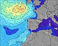 | 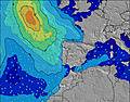 | 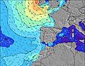 | 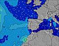 | |||||||||||||
Wave Height (m) Direction Period (s) | W 9 | WNW 8 | WNW 9 | WNW 9 | WNW 8 | WNW 8 | WNW 4 | NW 4 | WNW 8 | NW 4 | NW 5 | NW 5 | WNW 4 | NW 4 | WNW 5 | WNW 8 | NW 6 | WNW 10 | NW 4 | WNW 10 | WNW 10 |
Wave Graph | |||||||||||||||||||||
40 | 24 | 27 | 26 | 24 | 13 | 23 | 18 | 13 | 26 | 18 | 13 | 25 | 18 | 19 | 101 | 43 | 21 | 21 | 19 | 31 | |
Wind (km/h) | |||||||||||||||||||||
Wind State on-shore cross-onshore cross-shore cross-offshore off-shore glassy | on | cross-on | on | on | cross-on | cross-on | cross-on | cross | cross-on | cross-on | cross-on | cross-on | cross-on | cross-on | cross-on | cross-on | cross-on | cross-on | cross-on | cross-on | cross-on |
High Tide | 4:07PM3.10m | 4:37AM2.76m | 4:54PM3.11m | 5:23AM2.71m | 5:39PM3.03m | 6:08AM2.60m | 6:24PM2.87m | 6:53AM2.47m | 7:10PM2.65m | 7:39AM2.33m | 7:58PM2.41m | 8:30AM2.19m | 8:53PM2.19m | 9:28AM2.08m | |||||||
Low Tide | 10:27PM-0.07m | 10:35AM0.10m | 11:13PM-0.03m | 11:20AM0.15m | 11:58PM0.08m | 12:04PM0.27m | 00:42AM0.24m | 12:49PM0.42m | 1:26AM0.44m | 1:37PM0.60m | 2:13AM0.63m | 2:31PM0.78m | 3:05AM0.81m | ||||||||
— | — | 6:24 | — | — | 6:24 | — | — | 6:26 | — | — | 6:26 | — | — | 6:26 | — | — | 6:28 | — | — | 6:28 | |
— | 9:00 | — | — | 9:00 | — | — | 9:00 | — | 8:59 | — | — | 8:58 | — | — | 8:58 | — | — | 8:57 | — | 8:55 | |
mm | — | — | — | — | — | — | — | — | — | — | — | — | — | — | — | — | — | — | — | — | — |
Temp °C | 23 | 20 | 23 | 23 | 20 | 24 | 24 | 20 | 23 | 23 | 19 | 23 | 23 | 19 | 22 | 22 | 19 | 24 | 25 | 20 | 24 |
Feels °C | 22 | 20 | 22 | 22 | 20 | 21 | 20 | 18 | 20 | 20 | 18 | 21 | 20 | 18 | 20 | 20 | 18 | 22 | 22 | 19 | 22 |
Swell 1 Height (m) Direction Period (s) | W 9 | WNW 8 | WNW 9 | WNW 9 | WNW 8 | WNW 8 | SW 6 | WNW 8 | WNW 8 | S 19 | WNW 8 | WNW 8 | SW 18 | WNW 8 | WNW 5 | NW 12 | W 7 | WNW 5 | WNW 10 | WNW 10 | WNW 6 |
40 | 24 | 27 | 26 | 24 | 13 | 1 | 13 | 13 | 7 | 6 | 6 | 12 | 14 | 19 | 6 | 4 | 15 | 20 | 19 | 12 | |
Swell 2 Height (m) Direction Period (s) | SW 12 | WNW 5 | WNW 5 | S 11 | WNW 5 | W 6 | S 15 | SW 6 | W 5 | S 13 | W 11 | W 10 | NW 10 | NW 8 | W 8 | SW 16 | WNW 11 | NW 7 | SW 14 | NNW 6 | WNW 10 |
5 | 3 | 3 | 2 | 3 | 1 | 4 | 1 | 1 | 3 | 2 | 7 | 4 | 2 | 11 | 10 | 12 | 14 | 8 | 4 | 31 | |
Swell 3 Height (m) Direction Period (s) | SW 15 | SSW 13 | SW 4 | S 13 | S 14 | S 12 | S 10 | S 14 | S 13 | — | S 19 | S 18 | S 11 | NW 9 | NNW 8 | — | S 16 | WNW 10 | — | NNW 8 | NNW 10 |
8 | 16 | 1 | 3 | 4 | 3 | 2 | 4 | 3 | — | 7 | 6 | 3 | 3 | 7 | — | 5 | 21 | — | 6 | 9 | |
Wind waves Height (m) Direction Period (s) | — | WNW 3 | — | W 2 | NW 3 | WNW 5 | WNW 4 | NW 4 | NW 4 | NW 4 | NW 5 | NW 5 | WNW 4 | NW 4 | — | WNW 8 | NW 6 | — | NW 4 | WNW 5 | — |
— | 2 | — | 1 | 3 | 4 | 23 | 18 | 7 | 26 | 18 | 13 | 25 | 18 | — | 101 | 43 | — | 21 | 15 | — | |
Nearest Offshore or Glassy | |||||||||||||||||||||
Distance (km) | 521 | 13 | 943 | 351 | 9 | 545 | 1332 | 376 | 894 | 579 | 89 | 555 | 486 | 103 | 177 | 8 | 77 | 89 | 444 | 9 | 9 |
Best forecast wave conditions in Lisboa | |||||||||||||||||||||
Best forecast wave conditions in Portugal | |||||||||||||||||||||
Header Global | |||||||||||||||||||||
- Map Icons:
 Break
Break Live Wave Height (m)
 Live Wind Speed (km/h)
 Surf Rating (10 Max)
 Ocean Swells (m)
- Wind Speed (km/h)


FREE! Surf-Forecast.com widget for your website
The surf report / weather widget below is available to embed on third party websites free of charge and provides a summary of our Costa da Caparica surf forecast. Simply grab the html code snippet that we provide and paste it into your own site. You can choose your preferred language and metric/imperial units for the surf forecast feed to suit users of your site. Click here to get the code.
Information about the Costa da Caparica Surf forecast
The above surf forecast table for Costa da Caparica provides essential information for determining whether the surfing conditions will be good over the next 16 days. A general guide to surfing at Costa da Caparica can be found by selecting the local surf guide option on the grey menu. Our Costa da Caparica surf forecast is unique since it includes wave energy (power) that defines the real feel of the surf rather than just the height or the period. If you surf the same spot (Costa da Caparica) regularly then make a mental note of the wave energy from the surf forecast table each time you go. Very soon you may start to choose your surf days based on the wave energy alone combined with our forecast of favourable offshore wind conditions. Our star ratings will help here and of course you will also find the usual wave height and period predictions on our surf forecasts as well as a full break down of the swell components under our advanced users option (to reveal that, click the little Einstein character under the tide times).
Further information to help with frequently asked questions about our surf forecast for Costa da Caparica may be found under the help tab on the top menu and also by moving your mouse over the question marks on the surf forecast table itself. Please always bear in mind that the forecast is for near-shore open water and local factors at each surf break influence the actual breaking wave height, such as the beach / reef profile, water depths offshore and shelter.
Costa da Caparica is 5 km (3 miles) from Caparica. If you plan a holiday in Lisboa, look for hotels and other accommodation in Caparica. Caparica has rooms for a wide range of budgets as well as car hire and transport links.
 Nearest