

Surf Forecasts:

Dracula surf forecast from 3 Aug 2026:
- Best quality surf: Friday 7 Aug, 10PM (local time) - 10ft (3.0m), 8s period, NNW swell with cross-offshore winds.
- Most powerful swell: Friday 7 Aug, 10PM (local time) - 10ft (3.0m), 8s period, NNW swell with 1,046 kJ wave energy.
- Next surfable swell (1★+): Thursday 6 Aug, 1AM (local time) - 7ft (2.2m), 8s period with NNW swell.
Best Forecast Surf Conditions for Dracula this week:
The surf forecast for Dracula over the next 16 days: The first swell (rated 1 star or higher) is forecast to arrive on Thursday (Aug 06) at 1AM. The primary swell is predicted to be 2.2m and 8s period. The wind is predicted to be cross-offshore as the swell arrives.
The most powerful waves expected at Dracula in the next 16 days are 3.0m 8s and forecast to arrive on Friday (Aug 07) at 10PM. Winds are predicted to be cross-offshore at the time the swell arrives.
| Wave Type | Time (+01) & Date | Wave Height & Period |
|---|---|---|
| Next good surf (1 star+) | 1AM (Thu 6th Aug) | 7ft (2.2m) 8s |
| Best Surf | 10PM (Fri 7th Aug) | 10ft (3.0m) 8s |
| Most Powerful | 10PM (Fri 7th Aug) | 10ft (3.0m) 8s |
Table - best surf conditions forecast for Dracula over the next 16 days.
The Lowdown
Alright folks, Rusty here. Let’s have a look at what’s coming down the pipe for Dracula. This is a proper reef break, and it’s exposed to the west-northwest swell. The water is sitting at 72°, which is about a degree and a half warmer than average for this time of year – nothing crazy, but a touch on the balmy side.
The next couple of weeks are a mixed bag. We’ve got a solid run of NNW swell, but the wind is going to be a real pain in the arse for most of it. The first real standout that gets my heart pumping is the morning of Thursday, August 6th. The swell is a clean 6ft from the NNW, and the wind is a light cross-offshore breeze. The ocean is going to be clean, with the combined energy a solid 430 (moderate). That’s the sort of window you want to be in the water for.
Then, the absolute best of the whole forecast? That’s Friday morning, August 7th. We’re looking at a 7ft, 8-second swell from the NNW, with glassy conditions. That’s a proper, clean, glassy morning at Dracula. The combined energy jumps to 666 (moderate-to-strong). This is the one to circle on the calendar. Get the wax on the board the night before. The swell is over 7ft, so this is getting into expert territory – it’s going to be big and powerful on that reef.
After that, it’s a bit of a slog with cross and cross-onshore winds building through the afternoons, but there are a few more windows. Sunday morning, August 9th offers a clean 6ft with a light cross-offshore breeze (energy of 461). Another morning to sneak in a session.
The second week gets a little more promising towards the end. Thursday morning, August 14th and Friday morning, August 15th both have glassy conditions and a 5ft to 5ft swell. Nothing huge, but clean and fun for a reef break. The real kicker in the second week is Sunday morning, August 16th. Another glassy morning with a 7ft, 8-second swell from the NNW. The combined energy is 662. It’s a long way out, so the exact size might wobble, but the pattern looks promising for a solid, clean morning. This is a standout for the second week.
The afternoons are almost universally blown out by fresh cross-shore winds, so don't bother unless you're a masochist. For the most part, this is a dawn-patrol spot for the next two weeks.
Rusty.
Short Range ForecastMostly dry. Warm (max 30°C on Mon morning, min 22°C on Wed night). Winds increasing (light winds from the N on Mon morning, fresh winds from the N by Tue afternoon). | Days 4-6 Weather SummaryMostly dry. Warm (max 26°C on Thu morning, min 21°C on Thu night). Wind will be generally light. | ||||||||||||||||||||
Monday 3 | Tuesday 4 | Wednesday 5 | Thursday 6 | Friday 7 | Saturday 8 | Sunday 9 | |||||||||||||||
AM | PM | Night | AM | PM | Night | AM | PM | Night | AM | PM | Night | AM | PM | Night | AM | PM | Night | AM | PM | Night | |
Swell Height Map | 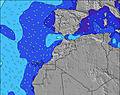 | 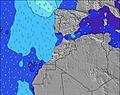 | 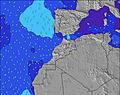 | 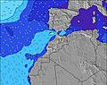 | 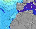 | 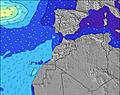 | 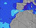 | ||||||||||||||
Wave Height (m) Direction Period (s) | NNW 7 | NNW 6 | NNW 7 | NNW 7 | NNW 7 | NNW 7 | NNW 7 | NNW 7 | NNW 8 | NNW 7 | NNW 8 | NNW 8 | NNW 8 | NNW 8 | NNW 8 | NNW 8 | NNW 8 | NNW 8 | NNW 7 | NNW 7 | NNW 7 |
Wave Graph | |||||||||||||||||||||
227 | 170 | 307 | 227 | 540 | 485 | 356 | 669 | 540 | 337 | 725 | 782 | 666 | 650 | 762 | 549 | 604 | 555 | 376 | 381 | 456 | |
Wind (km/h) | |||||||||||||||||||||
Wind State on-shore cross-onshore cross-shore cross-offshore off-shore glassy | cross | cross | cross | cross | cross | cross | cross | cross | cross-off | cross-off | cross | glassy | glassy | cross | glassy | cross-on | cross | cross-off | cross-off | cross | glassy |
High Tide | 5:37PM2.62m | 6:03AM2.40m | 6:19PM2.48m | 6:49AM2.30m | 7:11PM2.32m | 7:48AM2.20m | 8:19PM2.17m | 9:04AM2.14m | 9:46PM2.11m | 10:30AM2.20m | 11:14PM2.18m | 11:47AM2.38m | 00:26AM2.35m | ||||||||
Low Tide | 11:19AM0.42m | 11:48PM0.39m | 11:59AM0.52m | 00:30AM0.50m | 12:49PM0.64m | 1:23AM0.64m | 1:53PM0.76m | 2:33AM0.76m | 3:20PM0.81m | 4:02AM0.80m | 4:54PM0.72m | 5:25AM0.70m | 6:10PM0.52m | ||||||||
6:58 | — | — | 6:58 | — | — | 6:58 | — | — | 7:00 | — | — | 7:00 | — | — | 7:01 | — | — | 7:01 | — | — | |
— | 8:31 | — | — | 8:31 | — | — | 8:30 | — | — | 8:30 | — | — | 8:29 | — | — | 8:28 | — | — | 8:27 | — | |
mm | — | — | — | — | — | — | — | — | — | — | — | — | — | — | — | — | — | — | — | — | — |
Temp °C | 30 | 29 | 28 | 29 | 30 | 28 | 27 | 27 | 25 | 26 | 25 | 22 | 23 | 25 | 23 | 25 | 26 | 23 | 25 | 26 | 24 |
Feels °C | 29 | 26 | 25 | 26 | 25 | 25 | 25 | 23 | 22 | 25 | 23 | 22 | 24 | 24 | 24 | 25 | 25 | 23 | 25 | 24 | 24 |
Swell 1 Height (m) Direction Period (s) | WNW 8 | WNW 9 | NW 9 | NW 9 | — | WNW 11 | NW 8 | — | NNW 8 | NNW 7 | NW 8 | NNW 8 | NNW 8 | NW 8 | NNW 8 | NNW 8 | WNW 9 | NNW 8 | NW 7 | NW 7 | NNW 7 |
40 | 35 | 21 | 22 | — | 12 | 82 | — | 540 | 337 | 163 | 782 | 666 | 160 | 762 | 549 | 16 | 555 | 77 | 160 | 456 | |
Swell 2 Height (m) Direction Period (s) | N 9 | — | WNW 9 | WNW 9 | — | — | — | — | — | NNW 10 | WNW 10 | — | — | — | — | — | — | — | WNW 9 | — | N 12 |
6 | — | 15 | 32 | — | — | — | — | — | 52 | 19 | — | — | — | — | — | — | — | 8 | — | 3 | |
Swell 3 Height (m) Direction Period (s) | N 9 | — | — | — | — | — | — | — | — | WNW 10 | — | — | — | — | — | — | — | — | — | — | — |
6 | — | — | — | — | — | — | — | — | 41 | — | — | — | — | — | — | — | — | — | — | — | |
Wind waves Height (m) Direction Period (s) | NNW 7 | NNW 6 | NNW 7 | NNW 7 | NNW 7 | NNW 7 | NNW 7 | NNW 7 | — | — | NNW 8 | — | — | NNW 8 | — | — | NNW 8 | — | NNW 7 | NNW 7 | — |
227 | 170 | 307 | 227 | 540 | 485 | 356 | 669 | — | — | 725 | — | — | 650 | — | — | 604 | — | 376 | 381 | — | |
Nearest Offshore or Glassy | |||||||||||||||||||||
Distance (km) | 13 | 428 | 13 | 13 | 428 | 13 | 13 | 15 | 0 | 0 | 649 | 0 | 0 | 649 | 0 | 13 | 13 | 0 | 0 | 649 | 0 |
Best forecast wave conditions in Central Morocco | |||||||||||||||||||||
Best forecast wave conditions in Morocco | |||||||||||||||||||||
Header Global | |||||||||||||||||||||
- Map Icons:
 Break
Break Live Wave Height (m)
 Live Wind Speed (km/h)
 Surf Rating (10 Max)
 Ocean Swells (m)
- Wind Speed (km/h)
Latest Updates


FREE! Surf-Forecast.com widget for your website
The surf report / weather widget below is available to embed on third party websites free of charge and provides a summary of our Dracula surf forecast. Simply grab the html code snippet that we provide and paste it into your own site. You can choose your preferred language and metric/imperial units for the surf forecast feed to suit users of your site. Click here to get the code.
Information about the Dracula Surf forecast
The above surf forecast table for Dracula provides essential information for determining whether the surfing conditions will be good over the next 16 days. A general guide to surfing at Dracula can be found by selecting the local surf guide option on the grey menu. Our Dracula surf forecast is unique since it includes wave energy (power) that defines the real feel of the surf rather than just the height or the period. If you surf the same spot (Dracula) regularly then make a mental note of the wave energy from the surf forecast table each time you go. Very soon you may start to choose your surf days based on the wave energy alone combined with our forecast of favourable offshore wind conditions. Our star ratings will help here and of course you will also find the usual wave height and period predictions on our surf forecasts as well as a full break down of the swell components under our advanced users option (to reveal that, click the little Einstein character under the tide times).
Further information to help with frequently asked questions about our surf forecast for Dracula may be found under the help tab on the top menu and also by moving your mouse over the question marks on the surf forecast table itself. Please always bear in mind that the forecast is for near-shore open water and local factors at each surf break influence the actual breaking wave height, such as the beach / reef profile, water depths offshore and shelter.
Dracula is 24 km (15 miles) from the city of Agadir. If you plan a holiday in Central Morocco, look for hotels and other accommodation in Agadir. Agadir has rooms for a wide range of budgets as well as car hire and transport links.
 Nearest