

Surf Forecasts:

Safi Garden (Le Jardin) surf forecast from 2 Aug 2026:
- Best quality surf: Friday 7 Aug, 10AM (local time) - 5ft (1.5m), 7s period, NNW swell with offshore winds.
- Most powerful swell: Friday 7 Aug, 7PM (local time) - 5ft (1.6m), 8s period, NNW swell with 280 kJ wave energy.
- Next surfable swell (1★+): Friday 7 Aug, 10AM (local time) - 5ft (1.5m), 7s period with NNW swell.
Best Forecast Surf Conditions for Safi Garden (Le Jardin) this week:
The surf forecast for Safi Garden (Le Jardin) over the next 16 days: The first swell (rated 1 star or higher) is forecast to arrive on Friday (Aug 07) at 10AM. The primary swell is predicted to be 1.5m and 7s period with a secondary swell of 0.4m and 9s. The wind is predicted to be offshore as the swell arrives.
The most powerful waves expected at Safi Garden (Le Jardin) in the next 16 days are 1.6m 8s and forecast to arrive on Friday (Aug 07) at 7PM. Winds are predicted to be offshore at the time the swell arrives. The largest open ocean swell (not directed at the beach) is 1.5m 6s period and expected on Thursday (Aug 06) at 1PM.
| Wave Type | Time (+01) & Date | Wave Height & Period |
|---|---|---|
| Next good surf (1 star+) | 10AM (Fri 7th Aug) | 5ft (1.5m) 7s |
| Best Surf | 10AM (Fri 7th Aug) | 5ft (1.5m) 7s |
| Most Powerful | 7PM (Fri 7th Aug) | 5ft (1.6m) 8s |
Table - best surf conditions forecast for Safi Garden (Le Jardin) over the next 16 days.
The Lowdown
G’day, Rusty here. Look, I’ve been staring at the charts for Safi Garden and I gotta be straight with you—this ain’t a good stretch. We’ve got a solid 6 days of flat, weak dribble to kick things off, with hardly enough energy to push a sea-lion sideways. Waves are poor, and you’d be fighting the wind more than the wave. Let’s break it down day-by-day.
The water is absolutely freezing for the time of year, a staggering 62°F which is far colder than usual—you’ll want a solid 5/4 steamer, no joke.
From Saturday the 1st right through to midday Thursday the 6th, we’re looking at tiny 1ft to 2ft WNW slop. The periods are short (8-10 seconds) and the combined energy is weak (13 to 92). Winds are offshore or cross-off, so the ocean surface is clean, but there’s just no push. You’d be floating around on a longboard waiting for a bump that never really comes.
On Thursday afternoon the 6th, a short-period 6ft N swell rolls in but it’s building fast under a strong 28 mph offshore wind. That combo gives it an energy reading of 294 (moderate) but it’s brutal to paddle into—more of a kite-surfing set-up if you ask me.
Friday the 7th morning is the first time I’d even consider paddling out. We get a 5ft NNW swell at 7 seconds with a moderate offshore wind. Energy hits 261. It’s still not great, but this is the pick of a bad bunch. The wave comment calls it “expect good surf conditions.” Safi Garden (point break) is exposed to that optimum WNW direction, so it should hold some shape.
Saturday the 8th morning is similar—4ft NNW, 7 seconds, moderate offshore, 212 energy. Clean enough, but the swell is weak and wonky.
From Sunday the 9th through to Monday the 10th afternoon, the waves drop back to tiny 0.9ft to 1ft junk. Energy is tiny (13 to 24). Not worth it.
Tuesday the 11th brings a short-period 4ft to 4ft N swell but it’s messy with cross-off winds and only 123 to 141 energy. No quality.
Wednesday the 12th and Thursday the 13th are more of the same—2ft to 3ft WNW, 9 seconds, moderate energy (79 to 110). Afternoon winds get strong offshore again, so it’s clean but hard work.
Friday the 14th afternoon has a pulse of 5ft N swell at 6 seconds, energy 249. It’s poor surf conditions though, with a screaming 28 mph offshore. Hard to paddle into and short-period junk.
Saturday the 15th is similar—4ft to 5ft N swell, strong offshore winds, energy around 177 to 240. Still not good.
The only real beacon on the whole chart is Sunday the 16th morning. The combined energy jumps to 421 (strong), with 5ft NNW at 7 seconds and a moderate offshore cross-off wind. The wave comment is “marginal surf forecast” but the energy says there’s some juice. This could offer something decent, but it’s almost two weeks away, so treat it as promising but not locked in.
Honestly, if you’re desperate, try Friday the 7th morning or maybe Saturday the 8th morning for the cleanest small waves. But the real standout is Sunday the 16th morning—if the forecast holds, that’s your session. Until then, the board stays in the car.
Rusty.
Short Range ForecastMostly dry. Warm (max 30°C on Sun morning, min 21°C on Mon night). Mainly fresh winds. | Days 5-7 Weather SummaryMostly dry. Warm (max 25°C on Tue afternoon, min 20°C on Wed night). Winds decreasing (strong winds from the N on Thu afternoon, light winds from the NNE by Fri morning). | |||||||||||||||||||
Sat 1 | Sunday 2 | Monday 3 | Tuesday 4 | Wednesday 5 | Thursday 6 | Friday 7 | ||||||||||||||
PM | Night | AM | PM | Night | AM | PM | Night | AM | PM | Night | AM | PM | Night | AM | PM | Night | AM | PM | Night | |
Swell Height Map | 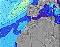 | 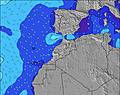 | 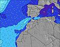 | 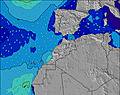 | 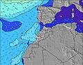 | 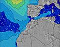 | 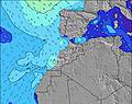 | |||||||||||||
Wave Height (m) Direction Period (s) | WNW 9 | NNW 6 | WNW 9 | WNW 9 | WNW 8 | WNW 10 | WNW 9 | WNW 9 | WNW 9 | WNW 9 | NW 8 | WNW 8 | WNW 8 | WNW 11 | WNW 10 | N 6 | N 7 | NNW 7 | NNW 8 | NNW 8 |
Wave Graph | ||||||||||||||||||||
48 | 66 | 46 | 45 | 22 | 54 | 34 | 32 | 33 | 53 | 33 | 61 | 45 | 75 | 59 | 239 | 181 | 228 | 273 | 240 | |
Wind (km/h) | ||||||||||||||||||||
Wind State on-shore cross-onshore cross-shore cross-offshore off-shore glassy | off | cross-off | cross-off | off | cross-off | cross-off | off | cross-off | cross-off | off | cross-off | cross-off | off | cross-off | cross-off | off | off | off | off | cross-off |
High Tide | 4:39PM2.58m | 4:59AM2.35m | 5:12PM2.53m | 5:35AM2.31m | 5:49PM2.44m | 6:14AM2.24m | 6:31PM2.32m | 7:01AM2.15m | 7:23PM2.17m | 7:59AM2.05m | 8:31PM2.03m | 9:15AM2.00m | 9:58PM1.97m | |||||||
Low Tide | 10:50PM0.23m | 10:55AM0.31m | 11:23PM0.27m | 11:31AM0.38m | 00:00AM0.35m | 12:12PM0.47m | 00:42AM0.45m | 1:01PM0.58m | 1:35AM0.58m | 2:05PM0.69m | 2:44AM0.70m | 3:30PM0.74m | ||||||||
— | — | 6:52 | — | — | 6:52 | — | — | 6:52 | — | — | 6:54 | — | — | 6:54 | — | — | 6:54 | — | — | |
8:35 | — | — | 8:34 | — | — | 8:32 | — | — | 8:31 | — | — | 8:30 | — | — | 8:30 | — | — | 8:29 | — | |
mm | — | — | — | — | — | — | — | — | — | — | — | — | — | — | — | — | — | — | — | — |
Temp °C | 26 | 29 | 30 | 29 | 25 | 27 | 26 | 22 | 26 | 25 | 22 | 25 | 25 | 22 | 25 | 25 | 21 | 24 | 25 | 22 |
Feels °C | 22 | 27 | 26 | 24 | 23 | 23 | 22 | 20 | 22 | 21 | 21 | 21 | 20 | 19 | 21 | 20 | 18 | 23 | 21 | 19 |
Swell 1 Height (m) Direction Period (s) | WNW 9 | NNW 6 | WNW 9 | WNW 9 | WNW 8 | WNW 10 | WNW 9 | WNW 9 | WNW 9 | WNW 9 | NW 8 | WNW 8 | WNW 8 | WNW 11 | WNW 10 | WNW 10 | NNW 8 | NNW 7 | WNW 9 | NNW 8 |
48 | 58 | 46 | 45 | 22 | 54 | 34 | 32 | 33 | 53 | 33 | 61 | 45 | 75 | 59 | 55 | 62 | 228 | 33 | 240 | |
Swell 2 Height (m) Direction Period (s) | N 12 | WNW 9 | NNW 10 | NW 10 | NNW 9 | NNW 8 | — | NNW 8 | N 7 | — | WNW 9 | N 8 | WNW 10 | NW 10 | NNW 9 | — | WNW 10 | WNW 9 | — | WNW 9 |
3 | 66 | 10 | 4 | 16 | 13 | — | 12 | 10 | — | 16 | 1 | 20 | 26 | 33 | — | 54 | 33 | — | 28 | |
Swell 3 Height (m) Direction Period (s) | — | N 11 | — | — | WNW 10 | — | — | N 6 | — | — | WNW 11 | N 11 | NW 12 | NW 8 | — | — | — | — | — | — |
— | 2 | — | — | 20 | — | — | 3 | — | — | 11 | 3 | 5 | 2 | — | — | — | — | — | — | |
Wind waves Height (m) Direction Period (s) | N 5 | — | N 6 | N 5 | N 6 | N 6 | N 5 | N 5 | N 4 | N 5 | N 5 | N 5 | N 5 | N 5 | N 6 | N 6 | N 7 | — | NNW 8 | — |
71 | — | 71 | 74 | 61 | 45 | 53 | 29 | 19 | 50 | 34 | 22 | 66 | 65 | 75 | 239 | 181 | — | 273 | — | |
Nearest Offshore or Glassy | ||||||||||||||||||||
Distance (km) | 581 | 28 | 200 | 582 | 14 | 173 | 582 | 200 | 173 | 527 | 200 | 200 | 530 | 173 | 173 | 242 | 173 | 0 | 525 | 173 |
Best forecast wave conditions in Central Morocco | ||||||||||||||||||||
Best forecast wave conditions in Morocco | ||||||||||||||||||||
Header Global | ||||||||||||||||||||
- Map Icons:
 Break
Break Live Wave Height (m)
 Live Wind Speed (km/h)
 Surf Rating (10 Max)
 Ocean Swells (m)
- Wind Speed (km/h)
Latest Updates


FREE! Surf-Forecast.com widget for your website
The surf report / weather widget below is available to embed on third party websites free of charge and provides a summary of our Safi Garden (Le Jardin) surf forecast. Simply grab the html code snippet that we provide and paste it into your own site. You can choose your preferred language and metric/imperial units for the surf forecast feed to suit users of your site. Click here to get the code.
Information about the Safi Garden (Le Jardin) Surf forecast
The above surf forecast table for Safi Garden (Le Jardin) provides essential information for determining whether the surfing conditions will be good over the next 16 days. A general guide to surfing at Safi Garden (Le Jardin) can be found by selecting the local surf guide option on the grey menu. Our Safi Garden (Le Jardin) surf forecast is unique since it includes wave energy (power) that defines the real feel of the surf rather than just the height or the period. If you surf the same spot (Safi Garden (Le Jardin)) regularly then make a mental note of the wave energy from the surf forecast table each time you go. Very soon you may start to choose your surf days based on the wave energy alone combined with our forecast of favourable offshore wind conditions. Our star ratings will help here and of course you will also find the usual wave height and period predictions on our surf forecasts as well as a full break down of the swell components under our advanced users option (to reveal that, click the little Einstein character under the tide times).
Further information to help with frequently asked questions about our surf forecast for Safi Garden (Le Jardin) may be found under the help tab on the top menu and also by moving your mouse over the question marks on the surf forecast table itself. Please always bear in mind that the forecast is for near-shore open water and local factors at each surf break influence the actual breaking wave height, such as the beach / reef profile, water depths offshore and shelter.
 Nearest