

Surf Forecasts:

Point Leo surf forecast from 3 Aug 2026:
- Best quality surf: Monday 10 Aug, 4PM (local time) - 13ft (4.0m), 16s period, SW swell with offshore winds.
- Most powerful swell: Monday 10 Aug, 7AM (local time) - 11ft (3.5m), 19s period, WSW swell with 8,748 kJ wave energy.
- Next surfable swell (1★+): Thursday 6 Aug, 1AM (local time) - 3.5ft (1.1m), 13s period with SW swell.
Best Forecast Surf Conditions for Point Leo this week:
The surf forecast for Point Leo over the next 16 days: The first swell (rated 1 star or higher) is forecast to arrive on Thursday (Aug 06) at 1AM. The primary swell is predicted to be 1.1m and 13s period with a secondary swell of 0.9m and 6s. The wind is predicted to be offshore as the swell arrives.
The most powerful waves expected at Point Leo in the next 16 days are 3.5m 19s and forecast to arrive on Monday (Aug 10) at 7AM. Winds are predicted to be cross-offshore at the time the swell arrives. The largest open ocean swell (not directed at the beach) is 1.3m 5s period and expected on Sunday (Aug 09) at 10AM.
| Wave Type | Time (AEST) & Date | Wave Height & Period |
|---|---|---|
| Next good surf (1 star+) | 1AM (Thu 6th Aug) | 3.5ft (1.1m) 13s |
| Best Surf | 4PM (Mon 10th Aug) | 13ft (4.0m) 16s |
| Most Powerful | 7AM (Mon 10th Aug) | 11ft (3.5m) 19s |
Table - best surf conditions forecast for Point Leo over the next 16 days.
The Lowdown
G’day, Rusty here. Look, the next couple of days at Point Leo are pretty average, but this outlook has a couple of absolute bombs waiting for you, especially if you’re an experienced surfer. Water temps are about average for this time of year, so nothing weird going on there.
We kick off Tuesday the 4th, and it’s a bit of a frustrating start. Morning sees a 6ft WSW swell, but that offshore NW wind is hitting 22 mph, making it a battle. It’s clean but messy, and with combined energy at 1089 (moderate), it’s not worth the hassle. Tuesday afternoon bumps up to 8ft SW, but the wind swings cross-off and the “marginal” tag keeps it average.
Wednesday the 5th drops off quickly – morning has 5ft SW with cross-off wind, and by the afternoon it’s down to a lousy 3ft SW. The swell period jumps to 14 seconds, which is good, but there’s just not enough size. Combined energy drops to 781 (moderate). Thursday the 6th is tiny – 3ft to 3ft of SW groundswell, with a very long 16-second period, but it’s clean with offshore winds. Combined energy is weak at 344 to 446. Not worth paddling out for.
Now, here’s where it gets good. Friday the 7th is the first standout. Morning hits with 5ft SW at a long 16-second period, combined energy of 1376 (moderate-strong), and a gentle 9 mph cross-off wind. It’s labelled excellent for experienced surfers. The afternoon stays clean with 5ft SW, light wind, and good energy (1459). This is the window for solid, clean waves.
Saturday the 8th is a tease – same 5ft SW swell with a 16-second period, but the wind jumps up to fresh breezes and the conditions turn marginal. Combined energy is still moderate-strong (1252-1365), but it’s not worth it with the wind. Sunday the 9th is a write-off with strong breeze and poor surf.
Monday the 10th is where the real magic happens for experts. The swell jumps to 13ft to 15ft of WSW groundswell, with combined energy hitting a massive 5521 to 14083 (strong to very strong). That Monday afternoon session is the pick – 13ft SW at a 16-second period, offshore breeze, and rated as exceptional. This is big, powerful, and clean. Only for experienced surfers.
Tuesday the 11th stays big – 10ft SW dropping to 8ft – but the fresh breeze makes it marginal. Energy is still high (3456-4275). Wednesday the 12th morning brings another beast: 15ft WSW, 16-second period, offshore wind, and combined energy at 15623 (very strong). Exceptional for experts again. The afternoon goes cross-shore and messy, so aim for the morning.
Thursday the 13th is the biggest of the run. Morning has 18ft SW, a 16-second period, light offshore breeze, and combined energy of 14856 (very strong). Exceptional conditions. The afternoon stays solid at 15ft SW. Both sessions are expert-only.
The swell drops from Friday the 14th onwards, with 8ft to 5ft SW through to the end of the 16-day window. Friday the 14th morning is good for experienced surfers – 8ft SW, 15-second period, clean. Saturday the 15th afternoon gets glassy with 5ft SW and combined energy of 1213 (moderate-strong) – that’s a sneaky good session. Sunday the 16th through Tuesday the 18th is mostly marginal or poor, with the swell fading and winds turning onshore. Wednesday the 19th finishes with a nice 7ft SW at 14 seconds, clean, and energy at 1663 – a solid, clean option for experienced surfers.
The real standouts are Monday the 10th afternoon, Wednesday the 12th morning, and Thursday the 13th all day for expert surfers. Friday the 7th is the best bet for strong intermediate crew. Keep in mind, that long-period SW groundswell can make beach breaks a bit too straight, but Point Leo is a reef setup, so it should handle it well. Crowds are possible here at times.
Rusty.
Short Range ForecastHeavy rain (total 20mm), heaviest during Mon night. Very mild (max 12°C on Tue afternoon, min 9°C on Mon night). Winds decreasing (fresh winds from the NW on Tue morning, light winds from the WNW by Wed night). | Days 5-7 Weather SummaryModerate rain (total 15mm), heaviest on Sun afternoon. Very mild (max 15°C on Sat morning, min 10°C on Fri night). Winds increasing (light winds from the W on Fri afternoon, near gales from the N by Sat night). | ||||||||||||||||||
Tuesday 4 | Wednesday 5 | Thursday 6 | Friday 7 | Saturday 8 | Sunday 9 | ||||||||||||||
Night | AM | PM | Night | AM | PM | Night | AM | PM | Night | AM | PM | Night | AM | PM | Night | AM | PM | Night | |
Swell Height Map |  |  |  |  | 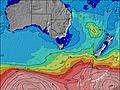 | 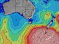 | 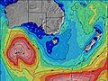 | ||||||||||||
Wave Height (m) Direction Period (s) | WSW 13 | WSW 11 | SW 11 | SW 10 | SW 10 | SW 19 | SW 13 | SW 12 | SW 16 | SW 14 | SW 16 | SW 15 | SW 14 | SW 16 | SW 16 | SW 15 | SW 14 | SW 14 | WSW 16 |
Wave Graph | |||||||||||||||||||
1349 | 634 | 1519 | 634 | 432 | 289 | 380 | 175 | 406 | 821 | 1267 | 966 | 742 | 1240 | 1317 | 953 | 676 | 681 | 2151 | |
Wind (km/h) | |||||||||||||||||||
Wind State on-shore cross-onshore cross-shore cross-offshore off-shore glassy | cross-off | off | cross-off | cross-off | cross-off | cross-off | off | off | off | cross-off | cross-off | cross-off | cross-off | cross-off | cross-off | cross-off | cross-off | cross-off | off |
High Tide | 3:15AM1.84m | 3:29PM2.04m | 3:56AM1.91m | 3:57PM2.03m | 4:37AM1.95m | 4:28PM2.02m | 5:22AM1.97m | 5:02PM1.99m | 6:11AM1.96m | 5:41PM1.95m | 7:08AM1.91m | 6:27PM1.90m | |||||||
Low Tide | 9:15AM0.47m | 9:47PM0.38m | 9:52AM0.52m | 10:20PM0.27m | 10:30AM0.60m | 10:55PM0.19m | 11:11AM0.69m | 11:36PM0.14m | 11:56AM0.80m | 00:23AM0.12m | 12:47PM0.91m | 1:19AM0.15m | |||||||
— | 7:18 | — | — | 7:18 | — | — | 7:16 | — | — | 7:15 | — | — | 7:13 | — | — | 7:13 | — | — | |
— | — | 5:32 | — | — | 5:32 | — | — | 5:34 | — | — | 5:35 | — | — | 5:36 | — | — | 5:37 | — | |
mm | 5 | 2 | 3 | 4 | 3 | 2 | — | — | 1 | 1 | — | — | — | — | 1 | 4 | 3 | 6 | 3 |
Temp °C | 10 | 10 | 12 | 11 | 12 | 12 | 12 | 11 | 12 | 12 | 12 | 13 | 12 | 15 | 14 | 13 | 12 | 11 | 10 |
Feels °C | 4 | 3 | 6 | 7 | 7 | 6 | 8 | 5 | 8 | 7 | 8 | 10 | 9 | 9 | 7 | 5 | 3 | 2 | 1 |
Swell 1 Height (m) Direction Period (s) | WSW 13 | WSW 11 | S 16 | SW 10 | SW 10 | SW 14 | SW 13 | SW 12 | SW 16 | SW 18 | SW 16 | SW 15 | SW 14 | SW 16 | SW 16 | SW 15 | SW 14 | SW 14 | WSW 16 |
1349 | 634 | 20 | 634 | 432 | 289 | 380 | 175 | 406 | 522 | 1267 | 966 | 742 | 1240 | 1317 | 953 | 676 | 681 | 2151 | |
Swell 2 Height (m) Direction Period (s) | SW 17 | SW 13 | — | SW 21 | SW 20 | SW 19 | SW 6 | SW 16 | WSW 20 | WSW 15 | SSW 6 | SW 19 | SW 18 | SSW 6 | SSW 16 | SSW 15 | SSW 14 | SW 18 | SW 20 |
241 | 431 | — | 154 | 239 | 284 | 54 | 163 | 38 | 275 | 58 | 446 | 516 | 8 | 48 | 44 | 20 | 51 | 575 | |
Swell 3 Height (m) Direction Period (s) | — | SSW 16 | — | SW 21 | SW 14 | SSW 15 | SW 18 | SSW 5 | S 5 | SSW 18 | SSW 16 | SSW 6 | S 7 | SSW 6 | — | — | — | — | SW 20 |
— | 24 | — | 69 | 91 | 21 | 197 | 6 | 2 | 30 | 51 | 47 | 23 | 4 | — | — | — | — | 548 | |
Wind waves Height (m) Direction Period (s) | — | NW 4 | SW 11 | — | SW 6 | SW 8 | WSW 6 | W 5 | W 4 | SW 14 | — | — | — | N 3 | NNW 3 | N 4 | N 5 | WNW 4 | NW 4 |
— | 28 | 1519 | — | 50 | 187 | 49 | 20 | 18 | 821 | — | — | — | 4 | 9 | 47 | 81 | 35 | 31 | |
Nearest Offshore or Glassy | |||||||||||||||||||
Distance (km) | 62 | 69 | 78 | 8 | 66 | 66 | 0 | 0 | 0 | 53 | 0 | 0 | 0 | 35 | 30 | 102 | 460 | 166 | 324 |
Best forecast wave conditions in Mornington Peninsula | |||||||||||||||||||
Best forecast wave conditions in Australia | |||||||||||||||||||
Header Global | |||||||||||||||||||
- Map Icons:
 Break
Break Live Wave Height (m)
 Live Wind Speed (km/h)
 Surf Rating (10 Max)
 Ocean Swells (m)
- Wind Speed (km/h)
Latest Updates


FREE! Surf-Forecast.com widget for your website
The surf report / weather widget below is available to embed on third party websites free of charge and provides a summary of our Point Leo surf forecast. Simply grab the html code snippet that we provide and paste it into your own site. You can choose your preferred language and metric/imperial units for the surf forecast feed to suit users of your site. Click here to get the code.
Information about the Point Leo Surf forecast
The above surf forecast table for Point Leo provides essential information for determining whether the surfing conditions will be good over the next 16 days. A general guide to surfing at Point Leo can be found by selecting the local surf guide option on the grey menu. Our Point Leo surf forecast is unique since it includes wave energy (power) that defines the real feel of the surf rather than just the height or the period. If you surf the same spot (Point Leo) regularly then make a mental note of the wave energy from the surf forecast table each time you go. Very soon you may start to choose your surf days based on the wave energy alone combined with our forecast of favourable offshore wind conditions. Our star ratings will help here and of course you will also find the usual wave height and period predictions on our surf forecasts as well as a full break down of the swell components under our advanced users option (to reveal that, click the little Einstein character under the tide times).
Further information to help with frequently asked questions about our surf forecast for Point Leo may be found under the help tab on the top menu and also by moving your mouse over the question marks on the surf forecast table itself. Please always bear in mind that the forecast is for near-shore open water and local factors at each surf break influence the actual breaking wave height, such as the beach / reef profile, water depths offshore and shelter.
Point Leo is 24 km (15 miles) from Mornington. If you plan a holiday in Mornington Peninsula, look for hotels and other accommodation in Mornington. Mornington has rooms for a wide range of budgets as well as car hire and transport links.
 Nearest