

Surf Forecasts:

Peak Rock surf forecast from 3 Aug 2026:
- Best quality surf: Monday 10 Aug, 4PM (local time) - 11ft (3.5m), 16s period, SW swell with glassy winds.
- Most powerful swell: Monday 10 Aug, 10PM (local time) - 11ft (3.5m), 17s period, SW swell with 7,672 kJ wave energy.
- Next surfable swell (1★+): Thursday 6 Aug, 7AM (local time) - 2.5ft (0.8m), 12s period with SW swell.
Best Forecast Surf Conditions for Peak Rock this week:
The surf forecast for Peak Rock over the next 16 days: The first swell (rated 1 star or higher) is forecast to arrive on Thursday (Aug 06) at 7AM. The primary swell is predicted to be 0.8m and 12s period with a secondary swell of 0.9m and 6s. Another secondary swell of 1.1m and 5s is also forecast. The wind is predicted to be offshore as the swell arrives.
The most powerful waves expected at Peak Rock in the next 16 days are 3.5m 17s and forecast to arrive on Monday (Aug 10) at 10PM. Winds are predicted to be cross-offshore at the time the swell arrives. The largest open ocean swell (not directed at the beach) is 1.7m 5s period and expected on Sunday (Aug 09) at 10AM.
| Wave Type | Time (AEST) & Date | Wave Height & Period |
|---|---|---|
| Next good surf (1 star+) | 7AM (Thu 6th Aug) | 2.5ft (0.8m) 12s |
| Best Surf | 4PM (Mon 10th Aug) | 11ft (3.5m) 16s |
| Most Powerful | 10PM (Mon 10th Aug) | 11ft (3.5m) 17s |
Table - best surf conditions forecast for Peak Rock over the next 16 days.
The Lowdown
Alright, this is Rusty, and I’m looking at what’s on the table for Peak Rock. It’s a reef setup, fairly exposed to a SSW swell, and it’s a fairly consistent spot. The water is sitting at about 56°F right now, which is pretty much normal for this time of year, so nothing freaky there.
The next few days are a bit of a write-off, honestly. Monday afternoon kicks off with some lumpy 6ft swell and a cross-off wind that’s just too strong, making it marginal. Tuesday and Wednesday are even worse – strong winds, rain, and messy conditions. The swell drops right off on Wednesday morning to a tiny 2ft. We’re looking at a solid gap of poor to marginal surf through the start of the week.
Then we get a glimmer. Thursday the 6th of August morning sees the wind swing to a light offshore from the NW, and the swell is still small at 2ft, but it’s a long-period 16-second groundswell. The energy is weak (400), but the conditions are clean. It’s a promising start, but still small.
Now, Friday the 7th of August is your first real standout. The morning has a clean 5ft of SW swell with a 16-second period, light cross-off wind, and moderate energy (1250). But the afternoon is where it gets magic. The wind drops to glassy, and you’ve got a beautiful 5ft, 15-second swell. The energy jumps up (1440), and it’s described as excellent for experienced surfers. This is the best session of the first week. The wind will be glassy, so the reef should be smooth and clean. Get on it.
Saturday the 8th holds similar size, 5ft to 6ft, with a clean offshore wind in the afternoon, but the wind is a bit stronger. Still a solid, fun day.
Sunday the 9th is a write-off again. A near-gale offshore wind makes it near impossible to paddle into, even though the swell is 5ft. Too dangerous.
Now, here’s the big one. Monday the 10th of August is the other standout. We’ve got a serious pulse of energy coming in. The morning sees 12ft of SW swell, 17-second period, and the combined energy is massive (7126). The wind is a moderate cross-off, so it’s clean. But the afternoon is the real deal. The wind drops to glassy, and you’ve got 12ft of clean, long-period groundswell. This is a heavy, powerful reef wave. This is for experts only. The energy is huge (7063). If you’ve got the skills, this is the session of the whole forecast.
Tuesday the 11th is still big, with 10ft and a fresh offshore wind, but it’s a step down from Monday. Good for the brave.
After that, it gets wild. Wednesday the 12th sees 13ft with a near-gale offshore wind – hard to surf, but if you can handle it, it’s clean. The rest of the second week is a mess of strong winds, big swell, and poor conditions. Thursday the 13th and Friday the 14th are blown out. The wave energy is massive (over 10,000 on Friday afternoon), but with a strong cross-shore wind, it’s just a foamy mess. Saturday the 15th is even worse – 15ft of onshore slop.
The second week is mostly a washout for paddle surfing, unless you’re a kite surfer. The big swell and strong winds make Peak Rock look more interesting for kiting than surfing from the 13th onwards.
The only real bright spots are Friday the 7th of August afternoon for the glassy, clean conditions, and Monday the 10th of August afternoon for the massive, clean groundswell for experts. The rest is a gamble with the wind.
Rusty.
Short Range ForecastHeavy rain (total 20mm), heaviest during Mon night. Very mild (max 13°C on Mon afternoon, min 9°C on Mon night). Mainly fresh winds. | Days 5-7 Weather SummaryLight rain (total 6mm), mostly falling on Sun morning. Very mild (max 14°C on Sat morning, min 9°C on Fri morning). Winds increasing (calm on Fri afternoon, near gales from the N by Sat night). | |||||||||||||||||||
Mon 3 | Tuesday 4 | Wednesday 5 | Thursday 6 | Friday 7 | Saturday 8 | Sunday 9 | ||||||||||||||
PM | Night | AM | PM | Night | AM | PM | Night | AM | PM | Night | AM | PM | Night | AM | PM | Night | AM | PM | Night | |
Swell Height Map |  |  |  | 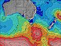 | 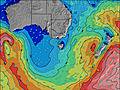 | 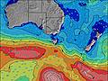 | 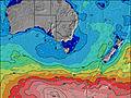 | |||||||||||||
Wave Height (m) Direction Period (s) | WSW 15 | WSW 13 | WSW 11 | SW 11 | SW 10 | SW 20 | SW 14 | SW 13 | SW 12 | SW 16 | SW 18 | SW 16 | SW 15 | SW 14 | SW 16 | SW 16 | SW 15 | SW 15 | SW 14 | SW 19 |
Wave Graph | ||||||||||||||||||||
1546 | 1349 | 634 | 1256 | 622 | 239 | 1255 | 282 | 206 | 406 | 528 | 1074 | 966 | 742 | 1384 | 1438 | 940 | 784 | 799 | 1445 | |
Wind (km/h) | ||||||||||||||||||||
Wind State on-shore cross-onshore cross-shore cross-offshore off-shore glassy | cross-off | cross-off | cross-off | cross | cross | cross | cross | cross-off | off | off | cross | cross-off | glassy | cross-off | cross-off | off | off | off | cross-off | cross-off |
High Tide | 3:15AM1.84m | 3:29PM2.04m | 3:56AM1.91m | 3:57PM2.03m | 4:37AM1.95m | 4:28PM2.02m | 5:22AM1.97m | 5:02PM1.99m | 6:11AM1.96m | 5:41PM1.95m | 7:08AM1.91m | 6:27PM1.90m | ||||||||
Low Tide | 9:16PM0.49m | 9:15AM0.47m | 9:47PM0.38m | 9:52AM0.52m | 10:20PM0.27m | 10:30AM0.60m | 10:55PM0.19m | 11:11AM0.69m | 11:36PM0.14m | 11:56AM0.80m | 00:23AM0.12m | 12:47PM0.91m | 1:19AM0.15m | |||||||
— | — | 7:18 | — | — | 7:18 | — | — | 7:16 | — | — | 7:16 | — | — | 7:13 | — | — | 7:13 | — | — | |
5:31 | — | — | 5:32 | — | — | 5:34 | — | — | 5:34 | — | — | 5:35 | — | — | 5:36 | — | — | 5:37 | — | |
mm | — | 4 | 2 | 3 | 8 | 2 | 1 | — | — | 1 | — | — | — | — | — | — | 2 | 3 | 1 | 2 |
Temp °C | 13 | 10 | 11 | 12 | 11 | 12 | 12 | 11 | 9 | 12 | 12 | 10 | 13 | 11 | 14 | 14 | 13 | 11 | 11 | 11 |
Feels °C | 6 | 4 | 4 | 5 | 7 | 7 | 6 | 6 | 3 | 7 | 6 | 8 | 11 | 7 | 8 | 7 | 5 | 1 | 2 | 2 |
Swell 1 Height (m) Direction Period (s) | WSW 15 | WSW 13 | WSW 11 | SW 11 | SW 10 | SW 13 | SW 19 | SW 6 | SW 12 | SW 16 | SW 18 | SW 16 | SW 15 | SW 14 | SW 16 | SW 16 | SW 15 | SW 15 | SW 14 | SW 12 |
1546 | 1349 | 634 | 1256 | 622 | 103 | 284 | 72 | 175 | 406 | 528 | 1074 | 966 | 742 | 1384 | 1438 | 940 | 784 | 799 | 1305 | |
Swell 2 Height (m) Direction Period (s) | S 20 | SW 17 | SW 13 | S 16 | SW 21 | SW 20 | SSW 15 | SW 13 | WSW 5 | SW 5 | SW 14 | SW 6 | SW 19 | SW 18 | SSW 17 | SSW 16 | WSW 18 | — | — | SW 19 |
7 | 241 | 431 | 5 | 154 | 239 | 21 | 282 | 19 | 10 | 211 | 60 | 441 | 516 | 57 | 86 | 127 | — | — | 1445 | |
Swell 3 Height (m) Direction Period (s) | — | — | — | — | S 21 | WSW 11 | SSW 19 | SW 18 | SW 16 | S 5 | WSW 10 | SSW 16 | SSW 6 | S 6 | SSW 6 | — | SSW 15 | — | — | SSW 19 |
— | — | — | — | 9 | 12 | 34 | 197 | 206 | 2 | 86 | 52 | 33 | 19 | 4 | — | 42 | — | — | 72 | |
Wind waves Height (m) Direction Period (s) | NW 4 | SW 14 | WNW 4 | SW 12 | — | SW 6 | SW 14 | — | NW 3 | WNW 3 | SW 7 | WSW 7 | — | — | N 3 | N 3 | NNW 5 | WNW 5 | WSW 7 | NW 5 |
13 | 1058 | 32 | 946 | — | 233 | 1255 | — | 2 | 8 | 178 | 64 | — | — | 7 | 8 | 66 | 147 | 621 | 76 | |
Nearest Offshore or Glassy | ||||||||||||||||||||
Distance (km) | 94 | 60 | 92 | 75 | 5 | 63 | 63 | 2 | 0 | 22 | 5 | 0 | 0 | 15 | 19 | 32 | 104 | 540 | 540 | 463 |
Best forecast wave conditions in Mornington Peninsula | ||||||||||||||||||||
Best forecast wave conditions in Australia | ||||||||||||||||||||
Header Global | ||||||||||||||||||||
- Map Icons:
 Break
Break Live Wave Height (m)
 Live Wind Speed (km/h)
 Surf Rating (10 Max)
 Ocean Swells (m)
- Wind Speed (km/h)
Latest Updates


FREE! Surf-Forecast.com widget for your website
The surf report / weather widget below is available to embed on third party websites free of charge and provides a summary of our Peak Rock surf forecast. Simply grab the html code snippet that we provide and paste it into your own site. You can choose your preferred language and metric/imperial units for the surf forecast feed to suit users of your site. Click here to get the code.
Information about the Peak Rock Surf forecast
The above surf forecast table for Peak Rock provides essential information for determining whether the surfing conditions will be good over the next 16 days. A general guide to surfing at Peak Rock can be found by selecting the local surf guide option on the grey menu. Our Peak Rock surf forecast is unique since it includes wave energy (power) that defines the real feel of the surf rather than just the height or the period. If you surf the same spot (Peak Rock) regularly then make a mental note of the wave energy from the surf forecast table each time you go. Very soon you may start to choose your surf days based on the wave energy alone combined with our forecast of favourable offshore wind conditions. Our star ratings will help here and of course you will also find the usual wave height and period predictions on our surf forecasts as well as a full break down of the swell components under our advanced users option (to reveal that, click the little Einstein character under the tide times).
Further information to help with frequently asked questions about our surf forecast for Peak Rock may be found under the help tab on the top menu and also by moving your mouse over the question marks on the surf forecast table itself. Please always bear in mind that the forecast is for near-shore open water and local factors at each surf break influence the actual breaking wave height, such as the beach / reef profile, water depths offshore and shelter.
Peak Rock is 25 km (16 miles) from Mornington. If you plan a holiday in Mornington Peninsula, look for hotels and other accommodation in Mornington. Mornington has rooms for a wide range of budgets as well as car hire and transport links.
 Nearest