

Surf Forecasts:

Platanitos surf forecast from 23 Jul 2026:
- Best quality surf: Saturday 25 Jul, 12AM (local time) - 4.5ft (1.3m), 21s period, SW swell with glassy winds.
- Most powerful swell: Wednesday 29 Jul, 3AM (local time) - 8ft (2.5m), 16s period, SW swell with 2,944 kJ wave energy.
- Next surfable swell (1★+): Wednesday 22 Jul, 9PM (local time) - 3ft (0.9m), 10s period with SW swell.
Best Forecast Surf Conditions for Platanitos this week:
The surf forecast for Platanitos over the next 16 days: The first swell (rated 1 star or higher) is forecast to arrive on Wednesday (Jul 22) at 9PM. The primary swell is predicted to be 0.9m and 10s period with a secondary swell of 0.6m and 14s. The wind is predicted to be offshore as the swell arrives.
The most powerful waves expected at Platanitos in the next 16 days are 2.5m 16s and forecast to arrive on Wednesday (Jul 29) at 3AM. Winds are predicted to be glassy at the time the swell arrives. The largest open ocean swell (not directed at the beach) is 2.2m 17s period and expected on Tuesday (Jul 28) at 9AM.
| Wave Type | Time (CST) & Date | Wave Height & Period |
|---|---|---|
| Next good surf (1 star+) | 9PM (Wed 22nd Jul) | 3ft (0.9m) 10s |
| Best Surf | 12AM (Sat 25th Jul) | 4.5ft (1.3m) 21s |
| Most Powerful | 3AM (Wed 29th Jul) | 8ft (2.5m) 16s |
Table - best surf conditions forecast for Platanitos over the next 16 days.
The Lowdown
Alright folks, Rusty here. Let’s have a look at what’s shaking for the next couple of weeks.
We’re looking at a solid run of surf, but it starts off a bit slow. The first few days are a bit of a write-off for anything decent, with only marginal waves on offer. The real action starts to build from Friday morning and carries through into the following week, with a strong pulse of SW groundswell.
The standout window is hands down the morning of Friday, July 24th through to Wednesday, July 29th. The pick of the bunch is Platanitos, a point break that’s fairly consistent and fairly exposed to the swell. The water is a touch warmer than normal for this time of year, coming in at 89°F, which is nice.
Friday morning, July 24th sees a clean 3ft SW swell with a long 24 second period. That’s a proper groundswell with real energy moving through (716). With offshore wind from the SSE, it’s going to be clean and lined up. This is a good one for intermediate surfers.
Saturday morning, July 25th is the absolute highlight. Glassy conditions, with the wind coming from the ESE. The swell is a touch bigger at 3ft from the SW, with a 21 second period. The energy is pumping (783) and the surf will be clean and well-shaped. The crowds can be a factor here though, so get in early.
Sunday morning, July 26th is another cracker. Glassy conditions again, with a 4ft SW swell and 18 second period. The energy is strong (962) and the sets will be sweet. There’s a risk of thunderstorms, but the surf will be worth it.
The swell continues to build into the next week. Wednesday morning, July 29th is for the experienced crew. The swell is pushing 6ft from the SW with a 13 second period, and the energy is ramping up (2043). Offshore wind from the SSE will keep it clean. This is solid, powerful surf.
Wednesday afternoon, July 29th is next level: a 8ft SW swell, with 14 second period, and glassy conditions. This is big, powerful, and only for experts. The energy is off the charts (1975). If you’re not solid, sit this one out.
Thursday morning, July 30th is still a great option for experienced surfers, with a 6ft SW swell, glassy, and clean. The energy is still strong (1338).
After that, the swell slowly backs off through the end of July and into August. The mornings remain the best bet with glassy or offshore winds, but the size drops. Friday morning, July 31st offers a 5ft WSW swell with glassy conditions, but it’s a bit less consistent.
The first week of August sees a return to smaller, more ordinary surf, with waist-high waves and weak energy. The mornings are still clean, but you’ll be scratching for a decent ride.
The bottom line: the best surf is from Friday, July 24th through Wednesday, July 29th, with the Saturday and Sunday mornings being the absolute standouts. Get on it.
Rusty.
Short Range ForecastHeavy rain (total 22mm), heaviest during Fri night. Warm (max 31°C on Wed morning, min 26°C on Fri night). Wind will be generally light. | Days 4-6 Weather SummaryHeavy rain (total 24mm), heaviest during Sat night. Warm (max 30°C on Sat afternoon, min 25°C on Mon night). Wind will be generally light. | ||||||||||||||||||||
Wednesday 22 | Thursday 23 | Friday 24 | Saturday 25 | Sunday 26 | Monday 27 | Tuesday 28 | |||||||||||||||
AM | PM | Night | AM | PM | Night | AM | PM | Night | AM | PM | Night | AM | PM | Night | AM | PM | Night | AM | PM | Night | |
Swell Height Map |  |  |  | 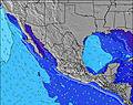 | 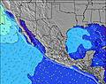 | 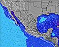 | 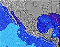 | ||||||||||||||
Wave Height (m) Direction Period (s) | SW 11 | SW 14 | SW 10 | SW 13 | SW 26 | SW 13 | SW 24 | SW 23 | SW 21 | SW 21 | SW 19 | SW 19 | SW 18 | SW 18 | SW 18 | SW 18 | SW 17 | SW 17 | W 9 | SW 16 | SW 16 |
Wave Graph | |||||||||||||||||||||
159 | 228 | 158 | 134 | 237 | 84 | 661 | 268 | 1625 | 756 | 945 | 1476 | 942 | 881 | 1099 | 1553 | 1048 | 1185 | 6 | 1333 | 1420 | |
Wind (km/h) | |||||||||||||||||||||
Wind State on-shore cross-onshore cross-shore cross-offshore off-shore glassy | cross-on | cross-on | cross-off | cross-off | cross-on | off | off | cross-on | glassy | glassy | cross-on | cross-off | glassy | cross-on | cross | cross-on | cross-on | cross-off | glassy | cross-on | cross |
High Tide | 3:39PM1.26m | 4:57PM1.28m | 9:15AM1.12m | 6:01PM1.33m | 9:10AM1.17m | 6:51PM1.40m | 9:20AM1.21m | 7:31PM1.48m | 9:36AM1.25m | 8:07PM1.55m | 9:55AM1.28m | 8:40PM1.60m | |||||||||
Low Tide | 00:44AM0.55m | 1:23AM0.44m | 12:44PM1.06m | 1:54AM0.33m | 1:25PM1.01m | 2:23AM0.24m | 1:55PM0.94m | 2:50AM0.17m | 2:22PM0.88m | 3:16AM0.13m | 2:48PM0.82m | ||||||||||
6:30 | — | — | 6:30 | — | — | 6:31 | — | — | 6:31 | — | — | 6:31 | — | — | 6:31 | — | — | 6:31 | — | — | |
— | 7:44 | — | — | 7:44 | — | — | 7:43 | — | — | 7:43 | — | — | 7:42 | — | — | 7:42 | — | — | 7:42 | — | |
mm | — | — | 1 | — | — | 2 | — | — | 19 | — | — | 7 | 1 | — | 9 | — | — | 7 | 1 | 4 | 6 |
Temp °C | 31 | 31 | 29 | 30 | 31 | 29 | 30 | 30 | 28 | 29 | 30 | 29 | 30 | 30 | 28 | 29 | 30 | 28 | 29 | 29 | 27 |
Feels °C | 34 | 35 | 35 | 34 | 35 | 35 | 34 | 34 | 32 | 33 | 34 | 34 | 33 | 34 | 31 | 31 | 33 | 33 | 32 | 32 | 31 |
Swell 1 Height (m) Direction Period (s) | SW 11 | SW 10 | SW 10 | SW 9 | SW 9 | WSW 9 | SW 24 | SW 23 | SW 21 | SW 21 | SW 19 | SW 19 | SW 18 | SW 18 | SW 18 | SW 18 | SW 17 | SW 17 | SSW 17 | SSW 12 | SW 12 |
159 | 208 | 148 | 86 | 62 | 73 | 661 | 268 | 1625 | 756 | 945 | 1476 | 942 | 881 | 1099 | 1553 | 1048 | 1185 | 2862 | 756 | 822 | |
Swell 2 Height (m) Direction Period (s) | SW 13 | SW 14 | SW 14 | SW 13 | SW 13 | SW 13 | WSW 9 | WSW 10 | W 9 | SSW 12 | W 8 | WSW 8 | WSW 8 | WSW 8 | WSW 8 | W 8 | SSW 11 | SSW 12 | W 9 | SW 16 | SW 16 |
183 | 228 | 158 | 134 | 136 | 84 | 55 | 55 | 56 | 56 | 34 | 21 | 20 | 24 | 13 | 12 | 210 | 288 | 6 | 1333 | 1420 | |
Swell 3 Height (m) Direction Period (s) | WSW 13 | SW 19 | W 5 | WNW 6 | SW 26 | WNW 6 | SSW 13 | SW 12 | SW 12 | WSW 8 | SSW 12 | SW 15 | SW 11 | SW 13 | — | SW 12 | W 11 | SSW 13 | W 9 | W 9 | W 9 |
111 | 59 | 9 | 10 | 237 | 11 | 111 | 75 | 72 | 27 | 55 | 76 | 30 | 45 | — | 23 | 2 | 35 | 6 | 6 | 6 | |
Wind waves Height (m) Direction Period (s) | — | WNW 4 | — | — | W 5 | — | — | W 6 | — | — | — | — | — | — | SW 3 | — | WNW 9 | — | — | — | — |
— | 7 | — | — | 9 | — | — | 12 | — | — | — | — | — | — | 9 | — | 15 | — | — | — | — | |
Nearest Offshore or Glassy | |||||||||||||||||||||
Distance (km) | 1 | 70 | 0 | 0 | 71 | 0 | 0 | 71 | 0 | 0 | 95 | 0 | 0 | 71 | 71 | 1 | 70 | 0 | 1 | 95 | 1 |
Best forecast wave conditions in Nayarit | |||||||||||||||||||||
Best forecast wave conditions in Mexico | |||||||||||||||||||||
Header Global | |||||||||||||||||||||
- Map Icons:
 Break
Break Live Wave Height (m)
 Live Wind Speed (km/h)
 Surf Rating (10 Max)
 Ocean Swells (m)
- Wind Speed (km/h)


FREE! Surf-Forecast.com widget for your website
The surf report / weather widget below is available to embed on third party websites free of charge and provides a summary of our Platanitos surf forecast. Simply grab the html code snippet that we provide and paste it into your own site. You can choose your preferred language and metric/imperial units for the surf forecast feed to suit users of your site. Click here to get the code.
Information about the Platanitos Surf forecast
The above surf forecast table for Platanitos provides essential information for determining whether the surfing conditions will be good over the next 16 days. A general guide to surfing at Platanitos can be found by selecting the local surf guide option on the grey menu. Our Platanitos surf forecast is unique since it includes wave energy (power) that defines the real feel of the surf rather than just the height or the period. If you surf the same spot (Platanitos) regularly then make a mental note of the wave energy from the surf forecast table each time you go. Very soon you may start to choose your surf days based on the wave energy alone combined with our forecast of favourable offshore wind conditions. Our star ratings will help here and of course you will also find the usual wave height and period predictions on our surf forecasts as well as a full break down of the swell components under our advanced users option (to reveal that, click the little Einstein character under the tide times).
Further information to help with frequently asked questions about our surf forecast for Platanitos may be found under the help tab on the top menu and also by moving your mouse over the question marks on the surf forecast table itself. Please always bear in mind that the forecast is for near-shore open water and local factors at each surf break influence the actual breaking wave height, such as the beach / reef profile, water depths offshore and shelter.
Platanitos is 36 km (22 miles) from the city of Compostela. If you plan a holiday in Nayarit, look for hotels and other accommodation in Compostela. Compostela has rooms for a wide range of budgets as well as car hire and transport links.
 Nearest