

Surf Forecasts:

Lacona or Tallinucci (Elba) surf forecast from 25 Jul 2026:
- Most powerful swell: Sunday 26 Jul, 2AM (local time) - 4.5ft (1.3m), 6s period, S swell with 101 kJ wave energy.
Best Forecast Surf Conditions for Lacona or Tallinucci (Elba) this week:
The most powerful waves expected at Lacona or Tallinucci (Elba) in the next 16 days are 1.3m 6s and forecast to arrive on Sunday (Jul 26) at 2AM. Winds are predicted to be onshore at the time the swell arrives. The largest open ocean swell (not directed at the beach) is 0.9m 4s period and expected on Friday (Jul 31) at 8PM.
| Wave Type | Time (CEST) & Date | Wave Height & Period |
|---|---|---|
| Next good surf (1 star+) | - | - |
| Best Surf | - | - |
| Most Powerful | 2AM (Sun 26th Jul) | 4.5ft (1.3m) 6s |
Table - best surf conditions forecast for Lacona or Tallinucci (Elba) over the next 16 days.
The Lowdown
Alright folks, Rusty here. Let’s have a look at what’s on offer for Lacona or Tallinucci on Elba over the next couple of weeks.
Right off the bat, I gotta be straight with you – the outlook is a tough one. We’ve got a solid 16-day window ahead, but it kicks off with a real flat spell and the surf never really gets going. From the very start right through to the end of the run, we’re looking at tiny, weak waves that just don’t have any push. The first few days are particularly grim, with nothing worth paddling out for.
The first whisper of something rideable shows up on the morning of Sunday the 26th of July. We’re talking a 3ft south swell with a period of 6 seconds, so it’s short-period windswell, not much grunt behind it. The combined energy is only sitting at 66 – weak. The wind is a clean offshore from the north, so it’ll be glassy, but the waves will be too small and weak to really get into. The water temperature is 84°, which is a full 8° warmer than usual for this time of year – that’s very unusual, so the water will feel like a warm bath.
Sunday afternoon drops off to 2ft, and Monday the 27th and Tuesday the 28th offer similar tiny dribbles in the 2ft to 2ft range, all from the south, with periods of 6 to 7 seconds. The energy numbers are all in the double digits, well under 100, confirming there’s no real power. The winds are mostly offshore or cross-offshore, so the surface will be clean, but the waves are just too small to get excited about.
From Wednesday the 29th of July onward, the swell completely packs up. We’re looking at 0.7ft or less, and then a long stretch of zeros from the 31st of July right through to the end of the forecast on the 9th of August. There’s a tiny blip of 0.7ft on the 2nd of August and again on the 6th and 7th, but with periods of 3 to 5 seconds and energy values of 1 to 3, it’s essentially flat. The wind stays clean, but it doesn’t matter when there’s nothing to ride.
So, what’s the best on offer? Honestly, there’s no single standout. If I had to pick the most surfable moment, it’s the early morning of Sunday the 26th of July. The 3ft south swell with a clean north offshore wind is the best combination we get. But even that’s a real struggle for a log or a foamy. For anyone looking for a proper wave, this is a blank run. It’s one of those periods where the Mediterranean just goes to sleep. The breaks are rarely breaking anyway, so a stretch like this is more normal for the area. Keep an eye on the forecasts though – they can shift.
Rusty.
Short Range ForecastSome drizzle, heaviest during Sun afternoon. Warm (max 27°C on Sat afternoon, min 26°C on Sun morning). Winds decreasing (fresh winds from the SSE on Sat night, calm by Sun night). | Days 5-7 Weather SummaryMostly dry. Warm (max 28°C on Wed afternoon, min 26°C on Tue night). Mainly fresh winds. | |||||||||||||||||||
Sat 25 | Sunday 26 | Monday 27 | Tuesday 28 | Wednesday 29 | Thursday 30 | Friday 31 | ||||||||||||||
PM | Night | AM | PM | Night | AM | PM | Night | AM | PM | Night | AM | PM | Night | AM | PM | Night | AM | PM | Night | |
Swell Height Map | 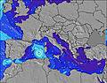 | 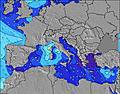 | 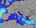 | 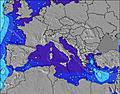 | 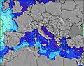 | 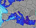 | 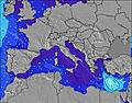 | |||||||||||||
Wave Height (m) Direction Period (s) | SE 4 | S 6 | S 6 | SSE 5 | S 6 | S 6 | S 6 | S 7 | S 7 | S 7 | SSE 7 | SSE 7 | S 7 | S 6 | S 6 | NW 3 | NW 4 | NW 3 | NW 3 | NW 4 |
Wave Graph | ||||||||||||||||||||
16 | 101 | 66 | 22 | 39 | 41 | 20 | 22 | 25 | 24 | 11 | 5 | 4 | 1 | 1 | 0 | 0 | 0 | 0 | 0 | |
Wind (km/h) | ||||||||||||||||||||
Wind State on-shore cross-onshore cross-shore cross-offshore off-shore glassy | on | on | off | cross-off | cross-off | cross-off | cross-off | off | off | cross-off | cross-off | off | cross-off | off | off | cross-off | cross-off | off | cross-off | off |
High Tide | 7:56PM0.28m | 7:41AM0.24m | 8:39PM0.30m | 8:25AM0.25m | 9:16PM0.31m | 9:03AM0.26m | 9:51PM0.33m | 9:38AM0.27m | 10:24PM0.34m | 10:12AM0.27m | 10:55PM0.35m | 10:46AM0.28m | 11:26PM0.35m | |||||||
Low Tide | 2:10AM0.13m | 1:55PM0.07m | 2:52AM0.11m | 2:36PM0.05m | 3:28AM0.10m | 3:13PM0.04m | 4:03AM0.09m | 3:47PM0.03m | 4:35AM0.08m | 4:19PM0.02m | 5:08AM0.08m | 4:52PM0.02m | ||||||||
— | — | 6:03 | — | — | 6:03 | — | — | 6:05 | — | — | 6:05 | — | — | 6:07 | — | — | 6:07 | — | — | |
8:46 | — | — | 8:45 | — | — | 8:45 | — | — | 8:44 | — | — | 8:43 | — | — | 8:42 | — | — | 8:40 | — | |
mm | — | — | — | 1 | — | — | — | — | — | — | — | — | — | — | — | — | — | — | — | — |
Temp °C | 27 | 27 | 27 | 27 | 27 | 26 | 27 | 27 | 26 | 27 | 27 | 27 | 28 | 28 | 27 | 28 | 28 | 27 | 31 | 29 |
Feels °C | 26 | 25 | 29 | 30 | 26 | 27 | 27 | 28 | 27 | 27 | 27 | 29 | 29 | 28 | 28 | 26 | 27 | 26 | 27 | 28 |
Swell 1 Height (m) Direction Period (s) | — | — | S 6 | SSE 5 | WNW 6 | S 6 | S 6 | S 7 | S 7 | S 7 | SSE 7 | W 4 | S 7 | S 6 | S 6 | — | — | — | — | — |
— | — | 66 | 22 | 47 | 41 | 20 | 22 | 25 | 24 | 11 | 2 | 4 | 1 | 1 | — | — | — | — | — | |
Swell 2 Height (m) Direction Period (s) | — | — | — | NW 6 | S 6 | WNW 7 | WNW 7 | W 8 | W 7 | W 7 | W 6 | SSE 7 | S 7 | — | — | — | — | — | — | — |
— | — | — | 1 | 39 | 18 | 5 | 4 | 4 | 1 | 1 | 5 | 3 | — | — | — | — | — | — | — | |
Swell 3 Height (m) Direction Period (s) | — | — | — | — | NW 7 | NNW 4 | SSW 5 | S 6 | — | — | — | — | — | — | — | — | — | — | — | — |
— | — | — | — | 2 | 1 | 2 | 1 | — | — | — | — | — | — | — | — | — | — | — | — | |
Wind waves Height (m) Direction Period (s) | SE 4 | S 6 | — | — | NNW 4 | — | — | NNW 3 | NNW 3 | NW 2 | NW 3 | NNW 3 | WNW 3 | NW 3 | NW 3 | NW 3 | NW 4 | NW 3 | NW 3 | NW 4 |
16 | 101 | — | — | 11 | — | — | 1 | 3 | 1 | 5 | 2 | 1 | 3 | 1 | 2 | 6 | 4 | 3 | 19 | |
Nearest Offshore or Glassy | ||||||||||||||||||||
Distance (km) | 790 | 91 | 5 | 279 | 40 | 43 | 406 | 60 | 85 | 343 | 948 | 671 | 981 | 959 | 968 | 1056 | 998 | 949 | 1139 | 543 |
Best forecast wave conditions in Elba | ||||||||||||||||||||
Best forecast wave conditions in Italy | ||||||||||||||||||||
Header Global | ||||||||||||||||||||
- Map Icons:
 Break
Break Live Wave Height (m)
 Live Wind Speed (km/h)
 Surf Rating (10 Max)
 Ocean Swells (m)
- Wind Speed (km/h)


FREE! Surf-Forecast.com widget for your website
The surf report / weather widget below is available to embed on third party websites free of charge and provides a summary of our Lacona or Tallinucci (Elba) surf forecast. Simply grab the html code snippet that we provide and paste it into your own site. You can choose your preferred language and metric/imperial units for the surf forecast feed to suit users of your site. Click here to get the code.
Information about the Lacona or Tallinucci (Elba) Surf forecast
The above surf forecast table for Lacona or Tallinucci (Elba) provides essential information for determining whether the surfing conditions will be good over the next 16 days. A general guide to surfing at Lacona or Tallinucci (Elba) can be found by selecting the local surf guide option on the grey menu. Our Lacona or Tallinucci (Elba) surf forecast is unique since it includes wave energy (power) that defines the real feel of the surf rather than just the height or the period. If you surf the same spot (Lacona or Tallinucci (Elba)) regularly then make a mental note of the wave energy from the surf forecast table each time you go. Very soon you may start to choose your surf days based on the wave energy alone combined with our forecast of favourable offshore wind conditions. Our star ratings will help here and of course you will also find the usual wave height and period predictions on our surf forecasts as well as a full break down of the swell components under our advanced users option (to reveal that, click the little Einstein character under the tide times).
Further information to help with frequently asked questions about our surf forecast for Lacona or Tallinucci (Elba) may be found under the help tab on the top menu and also by moving your mouse over the question marks on the surf forecast table itself. Please always bear in mind that the forecast is for near-shore open water and local factors at each surf break influence the actual breaking wave height, such as the beach / reef profile, water depths offshore and shelter.
Are you planning a holiday in Elba? If you are looking for accommodation near Lacona or Tallinucci (Elba), camping, hotels and holiday cottages in Elba, consider staying in Porto Azzurro which is 6 km (4 miles) away. Other places in and around Elba where you can find information about places to rent, and car hire include Portoferraio which is 7 km (4 miles) away, Rio Marina, Piombino and Follonica.
 Nearest