

Surf Forecasts:

Solanas surf forecast from 1 Aug 2026:
- Most powerful swell: Tuesday 4 Aug, 5AM (local time) - 2ft (0.6m), 4s period, SE swell with 13 kJ wave energy.
Best Forecast Surf Conditions for Solanas this week:
The most powerful waves expected at Solanas in the next 16 days are 0.6m 4s and forecast to arrive on Tuesday (Aug 04) at 5AM. Winds are predicted to be offshore at the time the swell arrives. The largest open ocean swell (not directed at the beach) is 0.6m 4s period and expected on Saturday (Aug 08) at 2AM.
| Wave Type | Time (CEST) & Date | Wave Height & Period |
|---|---|---|
| Next good surf (1 star+) | - | - |
| Best Surf | - | - |
| Most Powerful | 5AM (Tue 4th Aug) | 2ft (0.6m) 4s |
Table - best surf conditions forecast for Solanas over the next 16 days.
The Lowdown
Alright folks, Rusty here. Let's have a look at what Solanas has on offer over the next couple of weeks.
Right off the bat, I gotta tell you, it's a pretty bleak picture. We're looking at a long, dry spell with basically nothing happening. From now through to the 16th of August, there's just no swell to speak of. The wave energy is barely registering, with numbers like 10 or 12, and mostly it's flat – zero energy (0). It’s the kind of stretch where you’re better off waxing the longboard for a flat-water paddle or just taking the time to fix the dings. There are a few mornings with a light offshore breeze or even glassy conditions, but it doesn't matter when there's no wave to push you. That early morning glass on the 10th and 11th of August will just be a flat, pretty ocean.
The first real sign of life, and it's a small one, comes on the 17th of August, Monday morning. We'll finally see a pulse of swell pushing in. It's a modest 3ft from the WNW, but it's a short period at just 4 seconds. That's not going to have much grunt. The combined energy is still weak, sitting at just 36, so don't get your hopes up for anything with any power. The wind looks light from the NW, which should keep things clean, but the waves will be small and a bit crumbly. It’s beginner-friendly size for sure, so if you’re just learning or want a soft one, you might get a few fun ones. But this isn't a standout, it's just the only thing on the menu after a long flat spell.
For the whole 16-day run, there's nothing to get excited about. It's a frustrating wait for the Sardinian coast here. Usually, it doesn't stay this poor for this long, so keep an eye on the charts – things can change. But for now, this is a classic case of no surf being the main story.
Stay patient,
Rusty
Short Range ForecastMostly dry. Warm (max 32°C on Sat night, min 26°C on Sun night). Wind will be generally light. | Days 5-7 Weather SummaryMostly dry. Warm (max 35°C on Fri afternoon, min 25°C on Wed night). Winds increasing (calm on Thu morning, fresh winds from the NW by Fri afternoon). | ||||||||||||||||||
Sunday 2 | Monday 3 | Tuesday 4 | Wednesday 5 | Thursday 6 | Friday 7 | ||||||||||||||
Night | AM | PM | Night | AM | PM | Night | AM | PM | Night | AM | PM | Night | AM | PM | Night | AM | PM | Night | |
Swell Height Map | 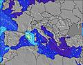 | 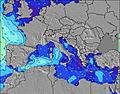 | 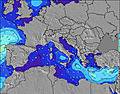 | 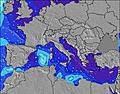 | 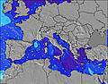 | 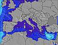 | 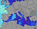 | ||||||||||||
Wave Height (m) Direction Period (s) | WSW 5 | N 3 | NE 3 | NE 3 | ENE 2 | ESE 2 | SE 4 | SE 5 | SE 4 | SE 4 | SE 5 | W 7 | SW 5 | WSW 6 | WSW 6 | WSW 4 | W 8 | SW 2 | W 6 |
Wave Graph | |||||||||||||||||||
2 | 0 | 0 | 0 | 0 | 0 | 6 | 10 | 9 | 6 | 8 | 4 | 6 | 7 | 4 | 4 | 1 | 1 | 1 | |
Wind (km/h) | |||||||||||||||||||
Wind State on-shore cross-onshore cross-shore cross-offshore off-shore glassy | cross | cross-off | cross | off | off | cross-off | cross-off | cross-off | cross-off | glassy | off | cross-on | off | glassy | cross | cross | cross | cross-on | cross |
High Tide | 00:14AM0.29m | 12:13PM0.22m | 00:45AM0.29m | 12:55PM0.22m | 1:18AM0.27m | 1:43PM0.22m | 1:56AM0.25m | 2:42PM0.21m | 2:43AM0.23m | 3:57PM0.21m | 3:47AM0.21m | 5:27PM0.22m | |||||||
Low Tide | 6:35AM0.06m | 6:12PM0.03m | 7:08AM0.06m | 6:50PM0.05m | 7:46AM0.05m | 7:34PM0.07m | 8:30AM0.06m | 8:31PM0.09m | 9:24AM0.06m | 9:49PM0.11m | 10:33AM0.06m | 11:32PM0.12m | |||||||
— | 6:22 | — | — | 6:22 | — | — | 6:24 | — | — | 6:24 | — | — | 6:26 | — | — | 6:26 | — | — | |
8:34 | — | 8:32 | — | — | 8:31 | — | — | 8:30 | — | — | 8:30 | — | — | 8:29 | — | — | 8:28 | — | |
mm | — | — | — | — | — | — | — | — | — | — | — | — | — | — | — | — | — | — | — |
Temp °C | 32 | 31 | 31 | 29 | 30 | 31 | 29 | 30 | 31 | 29 | 30 | 31 | 29 | 30 | 30 | 29 | 32 | 35 | 31 |
Feels °C | 33 | 33 | 33 | 32 | 31 | 32 | 31 | 32 | 33 | 32 | 33 | 33 | 31 | 33 | 32 | 31 | 32 | 34 | 28 |
Swell 1 Height (m) Direction Period (s) | WSW 5 | — | — | NNE 3 | — | — | SE 4 | SE 5 | SE 4 | SE 4 | SE 5 | SE 4 | SW 5 | WSW 6 | WSW 6 | WSW 4 | SW 6 | W 7 | W 6 |
2 | — | — | 1 | — | — | 6 | 10 | 9 | 6 | 8 | 3 | 6 | 7 | 4 | 4 | 1 | 1 | 1 | |
Swell 2 Height (m) Direction Period (s) | SE 5 | — | — | — | — | — | — | — | E 3 | W 7 | W 7 | W 7 | W 7 | SE 4 | — | W 6 | W 8 | — | — |
1 | — | — | — | — | — | — | — | 1 | 4 | 4 | 4 | 3 | 1 | — | 1 | 1 | — | — | |
Swell 3 Height (m) Direction Period (s) | N 6 | — | — | — | — | — | — | — | — | — | — | — | SE 4 | — | SE 4 | — | — | — | — |
1 | — | — | — | — | — | — | — | — | — | — | — | 1 | — | 1 | — | — | — | — | |
Wind waves Height (m) Direction Period (s) | NW 3 | N 3 | NE 3 | NE 3 | ENE 2 | ESE 2 | — | — | — | — | — | WSW 2 | E 4 | — | — | — | — | SW 2 | NW 4 |
1 | 1 | 2 | 1 | 1 | 1 | — | — | — | — | — | 1 | 1 | — | — | — | — | 1 | 10 | |
Nearest Offshore or Glassy | |||||||||||||||||||
Distance (km) | 1051 | 394 | 1182 | 1009 | 1009 | 1371 | 1042 | 1035 | 1470 | 1161 | 1009 | 1222 | 1035 | 664 | 1139 | 1118 | 120 | 1118 | 120 |
Best forecast wave conditions in Sardinia | |||||||||||||||||||
Best forecast wave conditions in Italy | |||||||||||||||||||
Header Global | |||||||||||||||||||
- Map Icons:
 Break
Break Live Wave Height (m)
 Live Wind Speed (km/h)
 Surf Rating (10 Max)
 Ocean Swells (m)
- Wind Speed (km/h)
Latest Updates


FREE! Surf-Forecast.com widget for your website
The surf report / weather widget below is available to embed on third party websites free of charge and provides a summary of our Solanas surf forecast. Simply grab the html code snippet that we provide and paste it into your own site. You can choose your preferred language and metric/imperial units for the surf forecast feed to suit users of your site. Click here to get the code.
Information about the Solanas Surf forecast
The above surf forecast table for Solanas provides essential information for determining whether the surfing conditions will be good over the next 16 days. A general guide to surfing at Solanas can be found by selecting the local surf guide option on the grey menu. Our Solanas surf forecast is unique since it includes wave energy (power) that defines the real feel of the surf rather than just the height or the period. If you surf the same spot (Solanas) regularly then make a mental note of the wave energy from the surf forecast table each time you go. Very soon you may start to choose your surf days based on the wave energy alone combined with our forecast of favourable offshore wind conditions. Our star ratings will help here and of course you will also find the usual wave height and period predictions on our surf forecasts as well as a full break down of the swell components under our advanced users option (to reveal that, click the little Einstein character under the tide times).
Further information to help with frequently asked questions about our surf forecast for Solanas may be found under the help tab on the top menu and also by moving your mouse over the question marks on the surf forecast table itself. Please always bear in mind that the forecast is for near-shore open water and local factors at each surf break influence the actual breaking wave height, such as the beach / reef profile, water depths offshore and shelter.
Solanas is 24 km (15 miles) from Quartu Sant'Elena. If you plan a holiday in Sardinia, look for hotels and other accommodation in Quartu Sant'Elena. Quartu Sant'Elena has rooms for a wide range of budgets as well as car hire and transport links.
 Nearest