

Surf Forecasts:

Capo Mannu Point surf forecast from 1 Aug 2026:
- Best quality surf: Friday 7 Aug, 11PM (local time) - 5ft (1.5m), 8s period, NW swell with cross-offshore winds.
- Most powerful swell: Friday 7 Aug, 8PM (local time) - 5ft (1.6m), 8s period, NW swell with 284 kJ wave energy.
- Next surfable swell (1★+): Friday 7 Aug, 5AM (local time) - 2ft (0.6m), 8s period with WNW swell.
Best Forecast Surf Conditions for Capo Mannu Point this week:
The surf forecast for Capo Mannu Point over the next 16 days: The first swell (rated 1 star or higher) is forecast to arrive on Friday (Aug 07) at 5AM. The primary swell is predicted to be 0.6m and 8s period with a secondary swell of 0.4m and 6s. The wind is predicted to be offshore as the swell arrives.
The most powerful waves expected at Capo Mannu Point in the next 16 days are 1.6m 8s and forecast to arrive on Friday (Aug 07) at 8PM. Winds are predicted to be cross-offshore at the time the swell arrives. The largest open ocean swell (not directed at the beach) is 0.7m 5s period and expected on Sunday (Aug 02) at 2PM.
| Wave Type | Time (CEST) & Date | Wave Height & Period |
|---|---|---|
| Next good surf (1 star+) | 5AM (Fri 7th Aug) | 2ft (0.6m) 8s |
| Best Surf | 11PM (Fri 7th Aug) | 5ft (1.5m) 8s |
| Most Powerful | 8PM (Fri 7th Aug) | 5ft (1.6m) 8s |
Table - best surf conditions forecast for Capo Mannu Point over the next 16 days.
The Lowdown
Alright folks, Rusty here. Let’s have a look at what’s cooking for the next couple of weeks at Capo Mannu Point. For a spot that usually delivers, we’re looking at a pretty flat spell to start, so don’t rush to grab your board just yet.
The first week is a real struggle. We’ve got a long stretch of tiny, weak swell that barely gets going. From Sunday the 2nd all the way through to Thursday the 7th, it’s mostly poor conditions with waves rarely breaking over 1 foot to 1.5 feet. The swell energy is painfully low, often sitting in the single digits (5) to low teens (16). You’ll see a few moments of glassy or clean conditions, like Thursday morning the 6th with light ESE winds, but there just isn’t enough swell to push through. The wind is a mixed bag, with some light offshore or cross-off moments, but the ocean is mostly asleep. Nothing to get excited about here.
We finally get a little pulse on Friday morning the 7th. A 2-foot NW swell with a 7-second period and light north winds gives us the first surfable but very ordinary waves. The energy is still weak (47), but at least it’s clean. Saturday morning the 8th is similar with a 3.5-foot NW swell, glassy conditions, and a bit more energy (110), but it’s still pretty average. The afternoon winds pick up NW at 12 mph, which will mess up the surface. We see the same pattern repeat on Sunday the 9th and Monday the 10th, with small, inconsistent waves and building wind.
The real wait is for the second week, and it’s worth it. After a flat Tuesday and Wednesday, we get a standout morning on Saturday the 15th. The swell jumps to 6.2 feet from the NW, with a 9 mph WNW cross-off breeze and a period of 8 seconds. The energy really kicks up to 470, and conditions are clean. This is the first time the setup looks proper. The swell is getting a bit big for beginners, but it’s manageable for anyone with some experience. The swell direction is SW-optimum, and NW is close enough to light it up.
But the absolute highlight is Monday morning the 17th. This is the one you’ve been waiting for. A solid 11.5-foot NW swell rolls in with a 9-second period, and the wind is light NE at 3 mph, delivering glassy conditions. The combined energy is massive at 1756, and the forecast says excellent surf for experienced surfers. This is a big, powerful groundswell that will wrap into the reef with real punch. With that size, it’s strictly for experts. The offshore wind will keep it clean and lined up. This is a day that could be truly special, but it’s more than a week out, so keep an eye on the charts.
Week two is a patchy affair, but Monday the 17th is the one to circle. The water is about average for this time of year, so no surprises there. Crowds are always a possibility here, so get in early if you can.
That’s your lot from me. This is a slow burn, but the payoff at the end looks worth the wait.
Short Range ForecastMostly dry. Warm (max 33°C on Tue afternoon, min 25°C on Sat night). Wind will be generally light. | Days 5-7 Weather SummaryMostly dry. Warm (max 30°C on Wed morning, min 24°C on Thu night). Wind will be generally light. | ||||||||||||||||||
Sunday 2 | Monday 3 | Tuesday 4 | Wednesday 5 | Thursday 6 | Friday 7 | ||||||||||||||
Night | AM | PM | Night | AM | PM | Night | AM | PM | Night | AM | PM | Night | AM | PM | Night | AM | PM | Night | |
Swell Height Map | 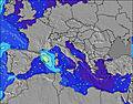 | 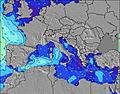 | 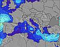 | 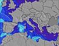 | 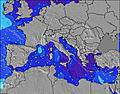 | 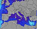 | 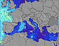 | ||||||||||||
Wave Height (m) Direction Period (s) | NW 4 | NW 6 | NW 5 | NW 4 | NNW 4 | NW 4 | S 4 | S 3 | W 8 | WSW 7 | WSW 6 | WSW 7 | WSW 6 | WSW 6 | WSW 7 | WSW 6 | NW 7 | NW 8 | NW 8 |
Wave Graph | |||||||||||||||||||
0 | 5 | 0 | 0 | 0 | 1 | 3 | 1 | 1 | 26 | 16 | 15 | 16 | 13 | 9 | 7 | 39 | 93 | 210 | |
Wind (km/h) | |||||||||||||||||||
Wind State on-shore cross-onshore cross-shore cross-offshore off-shore glassy | cross-off | off | cross-off | cross | cross | cross-off | cross-on | cross | cross | glassy | cross | cross-off | off | glassy | cross-off | off | off | cross-off | off |
High Tide | 00:01AM0.27m | 11:48AM0.19m | 00:29AM0.26m | 12:33PM0.18m | 1:00AM0.25m | 1:27PM0.18m | 1:35AM0.23m | 2:34PM0.18m | 2:19AM0.21m | 4:02PM0.18m | 3:20AM0.19m | 5:40PM0.20m | |||||||
Low Tide | 6:26AM0.07m | 5:44PM0.03m | 7:00AM0.07m | 6:21PM0.05m | 7:38AM0.06m | 7:05PM0.08m | 8:22AM0.06m | 8:02PM0.10m | 9:18AM0.06m | 9:30PM0.12m | 10:28AM0.06m | 11:31PM0.13m | |||||||
— | 6:24 | — | — | 6:24 | — | — | 6:26 | — | — | 6:26 | — | — | 6:28 | — | — | 6:28 | — | — | |
8:39 | — | 8:38 | — | — | 8:37 | — | — | 8:37 | — | — | 8:36 | — | — | 8:35 | — | — | 8:34 | — | |
mm | — | — | — | — | — | — | — | — | — | — | — | — | — | — | — | — | — | — | — |
Temp °C | 26 | 30 | 28 | 28 | 32 | 32 | 30 | 32 | 33 | 28 | 30 | 29 | 28 | 28 | 28 | 27 | 27 | 27 | 25 |
Feels °C | 28 | 30 | 29 | 30 | 33 | 30 | 33 | 32 | 32 | 32 | 30 | 31 | 30 | 29 | 28 | 29 | 29 | 27 | 25 |
Swell 1 Height (m) Direction Period (s) | — | NW 4 | — | NW 4 | NNW 4 | NW 4 | S 4 | S 3 | W 8 | WSW 7 | WSW 6 | WSW 7 | WSW 6 | WSW 6 | WSW 7 | WSW 6 | NW 7 | WSW 7 | NW 8 |
— | 4 | — | 5 | 2 | 1 | 3 | 1 | 1 | 26 | 16 | 15 | 16 | 13 | 9 | 7 | 39 | 4 | 210 | |
Swell 2 Height (m) Direction Period (s) | — | NW 6 | — | — | — | — | — | — | — | — | — | — | — | — | — | WNW 8 | WSW 6 | WSW 7 | WSW 6 |
— | 5 | — | — | — | — | — | — | — | — | — | — | — | — | — | 7 | 7 | 4 | 3 | |
Swell 3 Height (m) Direction Period (s) | — | — | — | — | — | — | — | — | — | — | — | — | — | — | — | W 8 | W 8 | — | — |
— | — | — | — | — | — | — | — | — | — | — | — | — | — | — | 1 | 1 | — | — | |
Wind waves Height (m) Direction Period (s) | NW 4 | — | NW 5 | — | — | — | — | — | — | SSW 3 | — | — | NNW 3 | NNW 3 | NW 3 | NW 3 | — | NW 8 | — |
3 | — | 27 | — | — | — | — | — | — | 1 | — | — | 2 | 1 | 1 | 2 | — | 93 | — | |
Nearest Offshore or Glassy | |||||||||||||||||||
Distance (km) | 925 | 298 | 1264 | 944 | 944 | 1248 | 913 | 908 | 1336 | 1062 | 944 | 1098 | 908 | 530 | 1014 | 993 | 0 | 993 | 0 |
Best forecast wave conditions in Sardinia | |||||||||||||||||||
Best forecast wave conditions in Italy | |||||||||||||||||||
Header Global | |||||||||||||||||||
- Map Icons:
 Break
Break Live Wave Height (m)
 Live Wind Speed (km/h)
 Surf Rating (10 Max)
 Ocean Swells (m)
- Wind Speed (km/h)
Latest Updates


FREE! Surf-Forecast.com widget for your website
The surf report / weather widget below is available to embed on third party websites free of charge and provides a summary of our Capo Mannu Point surf forecast. Simply grab the html code snippet that we provide and paste it into your own site. You can choose your preferred language and metric/imperial units for the surf forecast feed to suit users of your site. Click here to get the code.
Information about the Capo Mannu Point Surf forecast
The above surf forecast table for Capo Mannu Point provides essential information for determining whether the surfing conditions will be good over the next 16 days. A general guide to surfing at Capo Mannu Point can be found by selecting the local surf guide option on the grey menu. Our Capo Mannu Point surf forecast is unique since it includes wave energy (power) that defines the real feel of the surf rather than just the height or the period. If you surf the same spot (Capo Mannu Point) regularly then make a mental note of the wave energy from the surf forecast table each time you go. Very soon you may start to choose your surf days based on the wave energy alone combined with our forecast of favourable offshore wind conditions. Our star ratings will help here and of course you will also find the usual wave height and period predictions on our surf forecasts as well as a full break down of the swell components under our advanced users option (to reveal that, click the little Einstein character under the tide times).
Further information to help with frequently asked questions about our surf forecast for Capo Mannu Point may be found under the help tab on the top menu and also by moving your mouse over the question marks on the surf forecast table itself. Please always bear in mind that the forecast is for near-shore open water and local factors at each surf break influence the actual breaking wave height, such as the beach / reef profile, water depths offshore and shelter.
Are you planning a holiday in Sardinia? If you are looking for accommodation near Capo Mannu Point, camping, hotels and holiday cottages in Sardinia, consider staying in Oristano which is 23 km (14 miles) away. Other places in and around Sardinia where you can find information about places to rent, and car hire include Alghero which is 59 km (37 miles) away, Sassari, Iglesias and Nuoro.
 Nearest