

Surf Forecasts:

Hierro surf forecast from 2 Aug 2026:
- Most powerful swell: Saturday 8 Aug, 1AM (local time) - 4.5ft (1.4m), 9s period, N swell with 299 kJ wave energy.
Best Forecast Surf Conditions for Hierro this week:
The most powerful waves expected at Hierro in the next 16 days are 1.4m 9s and forecast to arrive on Saturday (Aug 08) at 1AM. Winds are predicted to be cross-onshore at the time the swell arrives.
| Wave Type | Time (WEST) & Date | Wave Height & Period |
|---|---|---|
| Next good surf (1 star+) | - | - |
| Best Surf | - | - |
| Most Powerful | 1AM (Sat 8th Aug) | 4.5ft (1.4m) 9s |
Table - best surf conditions forecast for Hierro over the next 16 days.
The Lowdown
Alright, Rusty here. Let's break down what's happening at Hierro, specifically the Derecha de los Alemanes break.
I gotta be honest, this 16-day look is a bit of a bummer. The swell is showing up consistently, with the wave energy climbing into a moderate range (124 to 596) and the wave face running between 3ft and 6ft. But the problem is the wind. That northerly wind is blowing cross-onshore or straight cross the whole time. We're talking a fresh breeze most days, 15 to 18 mph, which is going to chop things up and make it lumpy. The water's sitting at a warm 73°, about average for the time of year, so at least you won't be cold while you're waiting for a clean set.
Starting Sunday afternoon, the 2nd of August, we get a 3ft swell from the north with a short, weak 6-second period. The combined energy is only 124, and the wind is already on it. That's a hard pass.
Moving through the first week, Monday the 3rd through to Saturday the 8th, the swell ticks up a bit, reaching 5ft with periods stretching to 9 seconds by the 8th. The energy climbs too, hitting 337 on Saturday morning. Sounds promising, right? But that northerly wind doesn't let up. It's a constant cross-onshore mess. For a reef break like this, which needs that clean line, it's just not happening. The waves will be there, but they'll be choppy and hard to enjoy.
The second week, from the 9th of August onwards, the pattern holds. We see swell heights around 4ft to 6ft, with periods mostly in the 6 to 8-second range. The energy stays moderate, even pushing into the high 300s and low 400s. The 15th of August, a Saturday, has the biggest swell of the run at 6ft with a period of 8 seconds and energy of 596, but again, the wind is a fresh 18 mph cross-onshore. It's the same story, just with more water moving. This size, over 5ft, is already getting too much for beginners, and with that wind, it's a battle even for the experienced crew.
Honestly, there's not a single standout session in this whole 16-day window for Hierro. The swell is consistent, so it's not a total flat spell, but the quality is consistently poor. With the constant cross-onshore wind and a short-period swell that won't hold a shape, the setup is much more interesting for kite surfing than paddle surfing. You'd be fighting a bumpy, lumpy mess. It's a blank run for us, but given the swell energy, it's the wind that's the real spoiler here. Forecasts can change, but as it stands, keep the board in the car.
Rusty.
Short Range ForecastMostly dry. Warm (max 24°C on Mon morning, min 21°C on Sun night). Mainly fresh winds. | Days 5-7 Weather SummaryMostly dry. Warm (max 22°C on Wed afternoon, min 20°C on Thu night). Mainly fresh winds. | |||||||||||||||||||
Sun 2 | Monday 3 | Tuesday 4 | Wednesday 5 | Thursday 6 | Friday 7 | Saturday 8 | ||||||||||||||
PM | Night | AM | PM | Night | AM | PM | Night | AM | PM | Night | AM | PM | Night | AM | PM | Night | AM | PM | Night | |
Swell Height Map |  |  |  | 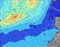 | 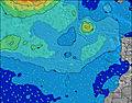 | 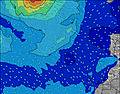 | 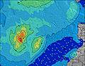 | |||||||||||||
Wave Height (m) Direction Period (s) | N 6 | N 6 | N 6 | N 6 | N 6 | N 6 | N 7 | NNE 6 | NNE 6 | N 6 | N 6 | NNE 6 | N 6 | N 6 | N 6 | N 8 | N 9 | N 9 | N 8 | N 8 |
Wave Graph | ||||||||||||||||||||
62 | 86 | 75 | 59 | 69 | 67 | 69 | 69 | 125 | 83 | 78 | 142 | 99 | 86 | 123 | 241 | 299 | 292 | 266 | 212 | |
Wind (km/h) | ||||||||||||||||||||
Wind State on-shore cross-onshore cross-shore cross-offshore off-shore glassy | cross-on | cross | cross-on | cross-on | cross | cross-on | cross-on | cross | cross | cross-on | cross | cross-on | cross-on | cross-on | cross-on | cross-on | cross-on | cross-on | cross-on | cross-on |
High Tide | 4:37PM2.33m | 5:00AM2.11m | 5:13PM2.24m | 5:39AM2.04m | 5:54PM2.12m | 6:25AM1.95m | 6:46PM1.97m | 7:24AM1.86m | 7:54PM1.84m | 8:41AM1.80m | 9:24PM1.77m | 10:10AM1.85m | 10:54PM1.83m | |||||||
Low Tide | 10:49PM0.24m | 10:56AM0.35m | 11:26PM0.31m | 11:36AM0.44m | 00:08AM0.42m | 12:26PM0.55m | 1:00AM0.54m | 1:30PM0.65m | 2:11AM0.65m | 2:57PM0.70m | 3:40AM0.68m | 4:33PM0.62m | ||||||||
— | — | 7:16 | — | — | 7:18 | — | — | 7:18 | — | — | 7:18 | — | — | 7:20 | — | — | 7:20 | — | — | |
8:45 | — | — | 8:45 | — | — | 8:45 | — | — | 8:44 | — | — | 8:43 | — | — | 8:42 | — | — | 8:40 | — | |
mm | — | — | — | — | — | — | — | — | — | — | — | — | — | — | — | — | — | — | — | — |
Temp °C | 23 | 23 | 24 | 24 | 22 | 24 | 23 | 22 | 22 | 22 | 21 | 21 | 21 | 20 | 21 | 22 | 21 | 22 | 22 | 21 |
Feels °C | 20 | 22 | 22 | 21 | 21 | 22 | 22 | 21 | 20 | 20 | 19 | 20 | 19 | 18 | 19 | 21 | 20 | 20 | 20 | 20 |
Swell 1 Height (m) Direction Period (s) | WNW 8 | N 6 | WNW 9 | WNW 9 | WNW 9 | ENE 7 | ENE 7 | WNW 8 | NW 8 | ENE 8 | ENE 8 | N 10 | NE 8 | N 9 | N 9 | WNW 9 | WNW 9 | WNW 9 | NW 8 | NW 8 |
47 | 86 | 55 | 32 | 34 | 27 | 37 | 47 | 16 | 55 | 40 | 52 | 64 | 60 | 81 | 32 | 31 | 30 | 18 | 17 | |
Swell 2 Height (m) Direction Period (s) | N 11 | WNW 10 | NE 7 | ENE 8 | N 9 | WNW 9 | NW 9 | N 8 | NW 10 | WNW 11 | WNW 10 | WNW 10 | N 10 | ENE 8 | WNW 9 | NW 9 | NE 8 | WNW 9 | WNW 9 | N 12 |
9 | 61 | 14 | 22 | 13 | 32 | 37 | 5 | 26 | 75 | 67 | 55 | 68 | 39 | 32 | 3 | 11 | 15 | 15 | 11 | |
Swell 3 Height (m) Direction Period (s) | N 9 | N 10 | N 9 | N 9 | — | N 8 | WNW 11 | — | N 11 | N 11 | NNW 11 | — | WNW 10 | WNW 9 | — | N 10 | N 9 | — | — | N 8 |
6 | 17 | 14 | 14 | — | 6 | 12 | — | 2 | 2 | 42 | — | 37 | 34 | — | 2 | 6 | — | — | 1 | |
Wind waves Height (m) Direction Period (s) | N 6 | NE 7 | N 6 | N 6 | N 6 | N 6 | N 7 | NNE 6 | NNE 6 | N 6 | N 6 | NNE 6 | N 6 | N 6 | N 6 | N 8 | N 9 | N 9 | N 8 | N 8 |
62 | 73 | 75 | 59 | 69 | 67 | 69 | 69 | 125 | 83 | 78 | 142 | 99 | 86 | 123 | 241 | 299 | 292 | 266 | 212 | |
Nearest Offshore or Glassy | ||||||||||||||||||||
Distance (km) | 18 | 19 | 18 | 277 | 18 | 215 | 18 | 215 | 215 | 282 | 215 | 215 | 215 | 215 | 215 | 176 | 445 | 446 | 215 | 288 |
Best forecast wave conditions in Fuerteventura | ||||||||||||||||||||
Best forecast wave conditions in Spain (Africa) | ||||||||||||||||||||
Header Global | ||||||||||||||||||||
- Map Icons:
 Break
Break Live Wave Height (m)
 Live Wind Speed (km/h)
 Surf Rating (10 Max)
 Ocean Swells (m)
- Wind Speed (km/h)
Latest Updates


FREE! Surf-Forecast.com widget for your website
The surf report / weather widget below is available to embed on third party websites free of charge and provides a summary of our Hierro surf forecast. Simply grab the html code snippet that we provide and paste it into your own site. You can choose your preferred language and metric/imperial units for the surf forecast feed to suit users of your site. Click here to get the code.
Information about the Hierro Surf forecast
The above surf forecast table for Hierro provides essential information for determining whether the surfing conditions will be good over the next 16 days. A general guide to surfing at Hierro can be found by selecting the local surf guide option on the grey menu. Our Hierro surf forecast is unique since it includes wave energy (power) that defines the real feel of the surf rather than just the height or the period. If you surf the same spot (Hierro) regularly then make a mental note of the wave energy from the surf forecast table each time you go. Very soon you may start to choose your surf days based on the wave energy alone combined with our forecast of favourable offshore wind conditions. Our star ratings will help here and of course you will also find the usual wave height and period predictions on our surf forecasts as well as a full break down of the swell components under our advanced users option (to reveal that, click the little Einstein character under the tide times).
Further information to help with frequently asked questions about our surf forecast for Hierro may be found under the help tab on the top menu and also by moving your mouse over the question marks on the surf forecast table itself. Please always bear in mind that the forecast is for near-shore open water and local factors at each surf break influence the actual breaking wave height, such as the beach / reef profile, water depths offshore and shelter.
Are you planning a holiday in Fuerteventura? If you are looking for accommodation near Hierro, camping, hotels and holiday cottages in Fuerteventura, consider staying in La Oliva which is 15 km (9 miles) away. Other places in and around Fuerteventura where you can find information about places to rent, and car hire include Puerto del Rosario which is 28 km (17 miles) away, Puerto del Carmen, Tias and Lanzarote.
 Nearest