

Surf Forecasts:

Greenough River Mouth surf forecast from 26 Jul 2026:
- Best quality surf: Saturday 1 Aug, 8PM (local time) - 10ft (3.0m), 15s period, SW swell with cross-offshore winds.
- Most powerful swell: Saturday 1 Aug, 2AM (local time) - 8ft (2.5m), 17s period, SW swell with 3,859 kJ wave energy.
- Next surfable swell (1★+): Monday 27 Jul, 8AM (local time) - 8ft (2.4m), 14s period with SW swell.
Best Forecast Surf Conditions for Greenough River Mouth this week:
The surf forecast for Greenough River Mouth over the next 16 days: The first swell (rated 1 star or higher) is forecast to arrive on Monday (Jul 27) at 8AM. The primary swell is predicted to be 2.4m and 14s period. The wind is predicted to be offshore as the swell arrives.
The most powerful waves expected at Greenough River Mouth in the next 16 days are 2.5m 17s and forecast to arrive on Saturday (Aug 01) at 2AM. Winds are predicted to be cross-onshore at the time the swell arrives. The largest open ocean swell (not directed at the beach) is 1.2m 6s period and expected on Saturday (Aug 01) at 11AM.
| Wave Type | Time (AWST) & Date | Wave Height & Period |
|---|---|---|
| Next good surf (1 star+) | 8AM (Mon 27th Jul) | 8ft (2.4m) 14s |
| Best Surf | 8PM (Sat 1st Aug) | 10ft (3.0m) 15s |
| Most Powerful | 2AM (Sat 1st Aug) | 8ft (2.5m) 17s |
Table - best surf conditions forecast for Greenough River Mouth over the next 16 days.
The Lowdown
Alright, Rusty here. Let’s have a look at what’s heading our way.
We’ve got a solid run of surf on the cards, starting this Monday, July 27th. The standout early on is Greenough River Mouth, which has excellent conditions for experienced surfers. The morning sees a 8ft SW swell with a period of 14 seconds and light ESE offshore winds. The water is 67°, which is a bit colder than usual for this time of year. The combined swell energy is moderate at 1977.
Monday afternoon stays clean with a 7ft SW swell, though winds shift to a cross-offshore breeze. Tuesday morning offers a 7ft SW swell with a 15-second period, but the wind is a cross-off. Tuesday afternoon picks up again with a clean 6ft SW swell and offshore ESE winds, making for another good session.
Wednesday morning is a write-off with stronger NE winds, but Wednesday afternoon brings a real highlight: a 6ft SW swell with a very long 17-second period, light easterly winds, and strong combined energy of 2752. This is a groundswell that will wrap nicely into the river mouth.
Thursday and Friday look a bit average with cross-onshore winds and small wind ripples. The swell drops, but it’s still rideable for the keen.
Then Saturday, August 1st, the swell picks up again. Morning brings 7ft from the SW with cross-off winds, and by the afternoon it’s 8ft with the same breeze. The energy is strong, but the conditions are only marginal for this spot.
Sunday, August 2nd, offers a clean morning with 8ft SW swell and offshore E winds – a beauty. Monday, August 3rd, holds clean 6ft surf.
But the next true standout is Tuesday, August 4th morning. Glassy conditions, a 6ft SW swell with a very long 19-second period, and strong energy at 2666. This is a real treat for experienced surfers, with the long-period groundswell favouring the river mouth setup.
Wednesday, August 5th morning also shines: 8ft SW swell, 17-second period, light cross-off winds, and strong energy of 3287. Excellent conditions for the experienced crew.
From Thursday, August 6th, things get big. The swell hits 10ft with very strong energy (5068), and while the wind is good, it’s just too big for Greenough River Mouth. This pattern continues through to the end of the forecast period – 10ft to 13ft SW swells, plenty of energy, but all too large for this break. August 8th looks particularly messy with strong SW winds and lumpy seas.
Best bets? Wednesday afternoon, July 29th, with the 6ft groundswell at 17 seconds and light winds, and Tuesday morning, August 4th, with glassy conditions and that 19-second energy. Both are top-tier for experienced surfers.
Stay safe out there.
- Rusty
Short Range ForecastMostly dry. Warm (max 22°C on Wed afternoon, min 11°C on Tue morning). Mainly fresh winds. | Days 4-6 Weather SummaryLight rain (total 2mm), mostly falling on Sat morning. Warm (max 21°C on Thu afternoon, min 10°C on Sat night). Winds increasing (calm on Thu night, fresh winds from the SSE by Sat afternoon). | ||||||||||||||||||||
Monday 27 | Tuesday 28 | Wednesday 29 | Thursday 30 | Friday 31 | Saturday 1 | Sunday 2 | |||||||||||||||
AM | PM | Night | AM | PM | Night | AM | PM | Night | AM | PM | Night | AM | PM | Night | AM | PM | Night | AM | PM | Night | |
Swell Height Map | 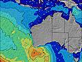 | 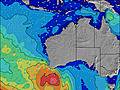 | 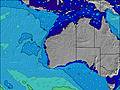 | 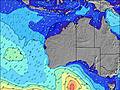 | 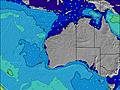 | 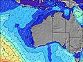 | 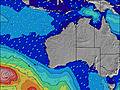 | ||||||||||||||
Wave Height (m) Direction Period (s) | SW 14 | SW 13 | SW 13 | SW 15 | SW 14 | SW 14 | SW 18 | SW 17 | SW 16 | SW 16 | SW 16 | SW 19 | SW 17 | SW 16 | SW 17 | SW 16 | SW 15 | SW 15 | SW 14 | SW 14 | SW 14 |
Wave Graph | |||||||||||||||||||||
1977 | 1544 | 1223 | 1647 | 1382 | 1063 | 754 | 1690 | 1230 | 897 | 875 | 608 | 1858 | 1474 | 3859 | 2434 | 3367 | 3197 | 2024 | 1729 | 1464 | |
Wind (km/h) | |||||||||||||||||||||
Wind State on-shore cross-onshore cross-shore cross-offshore off-shore glassy | off | cross-off | off | cross-off | off | cross-off | cross-off | cross-off | cross-off | cross | cross-on | cross-off | cross-on | cross-on | cross-on | cross-off | cross-off | off | off | cross-off | off |
High Tide | 8:32AM0.96m | 9:16AM0.96m | 9:57AM0.95m | 00:24AM0.57m | 10:36AM0.92m | 00:34AM0.59m | 11:16AM0.88m | 00:49AM0.63m | 11:56AM0.81m | 1:07AM0.67m | |||||||||||
Low Tide | 4:33PM0.29m | 4:55PM0.28m | 5:20PM0.29m | 5:45PM0.31m | 1:54AM0.56m | 6:08PM0.34m | 3:04AM0.56m | 6:28PM0.39m | 4:31AM0.56m | 6:43PM0.44m | |||||||||||
7:07 | — | — | 7:07 | — | — | 7:07 | — | — | 7:05 | — | — | 7:05 | — | — | 7:05 | — | — | 7:03 | — | — | |
— | 5:46 | — | — | 5:47 | — | — | 5:47 | — | — | 5:49 | — | — | 5:49 | — | — | 5:50 | — | — | 5:51 | — | |
mm | — | — | — | — | — | — | — | — | — | — | — | — | — | — | — | 1 | 1 | — | — | — | — |
Temp °C | 16 | 18 | 17 | 14 | 19 | 18 | 18 | 22 | 21 | 19 | 21 | 19 | 18 | 19 | 19 | 18 | 16 | 15 | 14 | 19 | 16 |
Feels °C | 12 | 14 | 13 | 8 | 15 | 13 | 11 | 17 | 17 | 14 | 17 | 19 | 16 | 17 | 18 | 18 | 11 | 10 | 9 | 15 | 10 |
Swell 1 Height (m) Direction Period (s) | SW 14 | SW 13 | SW 13 | SW 15 | SW 14 | SW 14 | SW 14 | SW 17 | SW 16 | SW 16 | SW 16 | SW 14 | SW 17 | SW 16 | SW 17 | SW 16 | SW 15 | SW 15 | SW 14 | SW 14 | SW 14 |
1977 | 1544 | 1223 | 1647 | 1382 | 1063 | 754 | 1690 | 1230 | 897 | 875 | 506 | 1858 | 1474 | 3859 | 2434 | 3367 | 3197 | 2024 | 1729 | 1464 | |
Swell 2 Height (m) Direction Period (s) | — | — | SW 24 | SW 22 | SW 21 | SW 19 | SW 18 | SW 17 | — | SW 22 | SW 20 | SW 19 | — | SW 20 | — | — | — | — | — | — | — |
— | — | 22 | 18 | 159 | 450 | 702 | 1062 | — | 73 | 194 | 608 | — | 660 | — | — | — | — | — | — | — | |
Swell 3 Height (m) Direction Period (s) | — | — | — | — | — | — | — | — | — | — | — | — | — | — | — | — | — | — | — | — | — |
— | — | — | — | — | — | — | — | — | — | — | — | — | — | — | — | — | — | — | — | — | |
Wind waves Height (m) Direction Period (s) | — | — | — | E 3 | — | E 3 | NE 4 | — | — | N 3 | — | — | — | — | — | S 6 | — | — | E 3 | — | — |
— | — | — | 6 | — | 8 | 18 | — | — | 3 | — | — | — | — | — | 92 | — | — | 4 | — | — | |
Nearest Offshore or Glassy | |||||||||||||||||||||
Distance (km) | 0 | 53 | 0 | 6 | 0 | 236 | 324 | 0 | 6 | 332 | 532 | 0 | 6 | 720 | 761 | 134 | 781 | 11 | 0 | 64 | 0 |
Best forecast wave conditions in North West WA | |||||||||||||||||||||
Best forecast wave conditions in Australia | |||||||||||||||||||||
Header Global | |||||||||||||||||||||
- Map Icons:
 Break
Break Live Wave Height (m)
 Live Wind Speed (km/h)
 Surf Rating (10 Max)
 Ocean Swells (m)
- Wind Speed (km/h)


FREE! Surf-Forecast.com widget for your website
The surf report / weather widget below is available to embed on third party websites free of charge and provides a summary of our Greenough River Mouth surf forecast. Simply grab the html code snippet that we provide and paste it into your own site. You can choose your preferred language and metric/imperial units for the surf forecast feed to suit users of your site. Click here to get the code.
Information about the Greenough River Mouth Surf forecast
The above surf forecast table for Greenough River Mouth provides essential information for determining whether the surfing conditions will be good over the next 16 days. A general guide to surfing at Greenough River Mouth can be found by selecting the local surf guide option on the grey menu. Our Greenough River Mouth surf forecast is unique since it includes wave energy (power) that defines the real feel of the surf rather than just the height or the period. If you surf the same spot (Greenough River Mouth) regularly then make a mental note of the wave energy from the surf forecast table each time you go. Very soon you may start to choose your surf days based on the wave energy alone combined with our forecast of favourable offshore wind conditions. Our star ratings will help here and of course you will also find the usual wave height and period predictions on our surf forecasts as well as a full break down of the swell components under our advanced users option (to reveal that, click the little Einstein character under the tide times).
Further information to help with frequently asked questions about our surf forecast for Greenough River Mouth may be found under the help tab on the top menu and also by moving your mouse over the question marks on the surf forecast table itself. Please always bear in mind that the forecast is for near-shore open water and local factors at each surf break influence the actual breaking wave height, such as the beach / reef profile, water depths offshore and shelter.
 Nearest