
Surf Forecasts:

Isolators surf forecast from 31 Jul 2026:
- Best quality surf: Saturday 1 Aug, 5PM (local time) - 10ft (3.0m), 15s period, WSW swell with cross-shore winds.
- Most powerful swell: Thursday 6 Aug, 8PM (local time) - 13ft (4.0m), 16s period, WSW swell with 7,288 kJ wave energy.
- Next surfable swell (1★+): Saturday 1 Aug, 5PM (local time) - 10ft (3.0m), 15s period with WSW swell.
Best Forecast Surf Conditions for Isolators this week:
The surf forecast for Isolators over the next 16 days: The first swell (rated 1 star or higher) is forecast to arrive on Saturday (Aug 01) at 5PM. The primary swell is predicted to be 3.0m and 15s period. The wind is predicted to be cross-shore as the swell arrives.
The most powerful waves expected at Isolators in the next 16 days are 4.0m 16s and forecast to arrive on Thursday (Aug 06) at 8PM. Winds are predicted to be onshore at the time the swell arrives. The largest open ocean swell (not directed at the beach) is 0.6m 4s period and expected on Sunday (Aug 02) at 11AM.
| Wave Type | Time (AWST) & Date | Wave Height & Period |
|---|---|---|
| Next good surf (1 star+) | 5PM (Sat 1st Aug) | 10ft (3.0m) 15s |
| Best Surf | 5PM (Sat 1st Aug) | 10ft (3.0m) 15s |
| Most Powerful | 8PM (Thu 6th Aug) | 13ft (4.0m) 16s |
Table - best surf conditions forecast for Isolators over the next 16 days.
The Lowdown
Alright folks, Rusty here. Let’s have a look at what’s on the cards for the next couple of weeks.
Right off the bat, I gotta be straight with you – the first few days are a write-off. We’re looking at a real messy start with strong winds and lumpy, choppy conditions. Nothing to get excited about until we get past that initial hump.
The first real chance of a wave comes on Sunday, August 2nd. The boys at Isolators are looking at a solid 8ft swell from the WSW, but the real story is the wind. On Sunday morning it’s a clean offshore from the NE at 12 mph, and by the afternoon it drops right off to a glassy 3 mph. That’s the kind of clean-up you want to see. The water temp is sitting at 66°, which is a touch warmer than normal for this time of year, so you might not need the thickest wetsuit. The wave energy is pumping hard, with a combined energy of 1427, so there’s plenty of push. The period is a long 14 seconds, so you’ll get those long, waiting sets – perfect for a reef setup like this. However, this swell is on the edge, just over 8ft, so it’s edging into expert territory. It’s a standout for the clean conditions, but only for the experienced crew.
Monday, August 3rd is another good shout. The swell drops a touch to 5ft, and we get a glassy flat calm in the morning with absolutely no wind. The energy is a moderate 936, and the period is a very long 15 seconds. That kind of period off a reef like Isolators can be a dream, but it can also make the waves a bit too straight for a beach break. This is a reef, so it should handle it well. The swell is more manageable, making it a good option for intermediate surfers looking for a clean, fun session.
After that, things go sideways again. From Tuesday, August 4th, the swell jumps up and stays big, mostly over 8ft and often hitting 10ft to 18ft. The wind is constantly cross-on or onshore, making it blown out and messy. The combined energy readings are massive, hitting four and even five-digit numbers like 5140 and 6460, which tells you there’s a ton of power, but it’s all going to waste with the wind. The setup looks more like a kite surfing day than a paddle session, with strong breezes and near gale-force winds forecast for the 8th of August. This is a long stretch of poor quality, lasting from the 4th right through to the 15th.
So, to put it simply: hold out for Sunday, August 2nd and Monday, August 3rd. Those are your two standout windows. After that, it’s a waiting game for the next weather system to sort itself out. The swell is there, but the wind is the enemy.
Rusty.
Short Range ForecastModerate rain (total 10mm), heaviest on Fri afternoon. Very mild (max 18°C on Fri morning, min 9°C on Sun morning). Winds decreasing (fresh winds from the WSW on Fri night, calm by Sun afternoon). | Days 4-6 Weather SummaryLight rain (total 4mm), mostly falling on Wed night. Very mild (max 17°C on Wed afternoon, min 13°C on Mon morning). Winds increasing (calm on Mon morning, fresh winds from the NW by Wed night). | ||||||||||||||||||||
Friday 31 | Saturday 1 | Sunday 2 | Monday 3 | Tuesday 4 | Wednesday 5 | Thursday 6 | |||||||||||||||
AM | PM | Night | AM | PM | Night | AM | PM | Night | AM | PM | Night | AM | PM | Night | AM | PM | Night | AM | PM | Night | |
Swell Height Map |  |  |  | 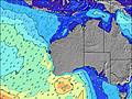 | 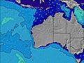 | 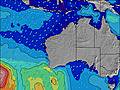 |  | ||||||||||||||
Wave Height (m) Direction Period (s) | WSW 16 | WSW 16 | WSW 16 | WSW 15 | WSW 15 | WSW 14 | WSW 14 | WSW 13 | WSW 14 | WSW 15 | WSW 16 | WSW 19 | WSW 17 | WSW 16 | WSW 16 | WSW 16 | WSW 16 | WSW 16 | WSW 16 | WSW 16 | WSW 15 |
Wave Graph | |||||||||||||||||||||
2542 | 3421 | 2355 | 3114 | 4334 | 3095 | 1862 | 1427 | 1212 | 936 | 1241 | 1247 | 4513 | 3676 | 3075 | 5140 | 5299 | 5372 | 3543 | 3336 | 6967 | |
Wind (km/h) | |||||||||||||||||||||
Wind State on-shore cross-onshore cross-shore cross-offshore off-shore glassy | cross | cross-on | cross-on | cross-on | cross | off | off | glassy | off | glassy | cross-on | cross | on | cross-on | on | cross | cross-on | cross-on | cross-on | on | cross-on |
High Tide | 10:03AM0.69m | 10:23AM0.64m | 1:45AM0.37m | 10:41AM0.57m | 1:36AM0.42m | 10:47AM0.49m | 1:49AM0.48m | 10:14AM0.40m | 2:24AM0.54m | 3:22AM0.60m | 4:34AM0.66m | ||||||||||
Low Tide | 6:25PM0.16m | 6:25PM0.19m | 3:56AM0.36m | 6:25PM0.23m | 5:31AM0.38m | 6:19PM0.26m | 7:27AM0.39m | 5:52PM0.28m | 3:25PM0.24m | 2:52PM0.15m | |||||||||||
7:13 | — | — | 7:11 | — | — | 7:11 | — | — | 7:09 | — | — | 7:09 | — | — | 7:09 | — | — | 7:07 | — | — | |
— | 5:38 | — | — | 5:39 | — | — | 5:40 | — | — | 5:40 | — | — | 5:42 | — | — | 5:43 | — | — | 5:43 | — | |
mm | 3 | 5 | 2 | — | — | — | — | — | — | — | — | — | — | 1 | — | — | — | 3 | 3 | 4 | 1 |
Temp °C | 18 | 18 | 16 | 14 | 14 | 13 | 11 | 13 | 13 | 14 | 16 | 16 | 16 | 16 | 16 | 16 | 17 | 17 | 18 | 16 | 15 |
Feels °C | 14 | 11 | 9 | 8 | 8 | 8 | 6 | 11 | 10 | 14 | 14 | 14 | 14 | 13 | 11 | 13 | 13 | 13 | 11 | 10 | 7 |
Swell 1 Height (m) Direction Period (s) | WSW 16 | WSW 16 | WSW 16 | WSW 15 | WSW 15 | WSW 14 | WSW 14 | WSW 13 | WSW 14 | WSW 15 | WSW 16 | WSW 14 | WSW 17 | WSW 16 | WSW 16 | WSW 16 | WSW 16 | WSW 16 | WSW 16 | WSW 16 | — |
2542 | 3421 | 2355 | 3114 | 4334 | 3095 | 1862 | 1427 | 1212 | 936 | 1241 | 1244 | 4513 | 3676 | 3075 | 5140 | 5299 | 5372 | 3543 | 3336 | — | |
Swell 2 Height (m) Direction Period (s) | — | — | — | — | — | — | — | NE 4 | — | — | — | WSW 19 | — | — | — | — | — | — | — | — | — |
— | — | — | — | — | — | — | 4 | — | — | — | 1247 | — | — | — | — | — | — | — | — | — | |
Swell 3 Height (m) Direction Period (s) | — | — | — | — | — | — | — | — | — | — | — | — | — | — | — | — | — | — | — | — | — |
— | — | — | — | — | — | — | — | — | — | — | — | — | — | — | — | — | — | — | — | — | |
Wind waves Height (m) Direction Period (s) | NW 4 | WNW 6 | SW 7 | — | — | — | ENE 4 | — | — | — | — | — | — | W 4 | — | — | — | — | NW 5 | WNW 7 | WSW 15 |
45 | 173 | 349 | — | — | — | 9 | — | — | — | — | — | — | 6 | — | — | — | — | 138 | 431 | 6967 | |
Nearest Offshore or Glassy | |||||||||||||||||||||
Distance (km) | 214 | 262 | 475 | 9 | 9 | 1 | 0 | 0 | 0 | 0 | 9 | 1 | 9 | 9 | 68 | 145 | 217 | 153 | 262 | 361 | 68 |
Best forecast wave conditions in Margaret River | |||||||||||||||||||||
Best forecast wave conditions in Australia | |||||||||||||||||||||
Header Global | |||||||||||||||||||||
- Map Icons:
 Break
Break Live Wave Height (m)
 Live Wind Speed (km/h)
 Surf Rating (10 Max)
 Ocean Swells (m)
- Wind Speed (km/h)
Latest Updates


FREE! Surf-Forecast.com widget for your website
The surf report / weather widget below is available to embed on third party websites free of charge and provides a summary of our Isolators surf forecast. Simply grab the html code snippet that we provide and paste it into your own site. You can choose your preferred language and metric/imperial units for the surf forecast feed to suit users of your site. Click here to get the code.
Information about the Isolators Surf forecast
The above surf forecast table for Isolators provides essential information for determining whether the surfing conditions will be good over the next 16 days. A general guide to surfing at Isolators can be found by selecting the local surf guide option on the grey menu. Our Isolators surf forecast is unique since it includes wave energy (power) that defines the real feel of the surf rather than just the height or the period. If you surf the same spot (Isolators) regularly then make a mental note of the wave energy from the surf forecast table each time you go. Very soon you may start to choose your surf days based on the wave energy alone combined with our forecast of favourable offshore wind conditions. Our star ratings will help here and of course you will also find the usual wave height and period predictions on our surf forecasts as well as a full break down of the swell components under our advanced users option (to reveal that, click the little Einstein character under the tide times).
Further information to help with frequently asked questions about our surf forecast for Isolators may be found under the help tab on the top menu and also by moving your mouse over the question marks on the surf forecast table itself. Please always bear in mind that the forecast is for near-shore open water and local factors at each surf break influence the actual breaking wave height, such as the beach / reef profile, water depths offshore and shelter.
Isolators is 65 km (40 miles) from the city of Bunbury. If you plan a holiday in Margaret River, look for hotels and other accommodation in Bunbury. Bunbury has rooms for a wide range of budgets as well as car hire and transport links.
 Nearest