

Surf Forecasts:

Frankport surf forecast from 30 Jul 2026:
- Best quality surf: Saturday 1 Aug, 2AM (local time) - 2ft (0.6m), 14s period, SW swell with cross-offshore winds.
- Most powerful swell: Tuesday 4 Aug, 5PM (local time) - 11ft (3.5m), 8s period, NNW swell with 1,457 kJ wave energy.
- Next surfable swell (1★+): Wednesday 29 Jul, 11PM (local time) - 3.5ft (1.0m), 8s period with WNW swell.
Best Forecast Surf Conditions for Frankport this week:
The surf forecast for Frankport over the next 16 days: The first swell (rated 1 star or higher) is forecast to arrive on Wednesday (Jul 29) at 11PM. The primary swell is predicted to be 1.0m and 8s period with a secondary swell of 0.8m and 4s. The wind is predicted to be cross-offshore as the swell arrives.
The most powerful waves expected at Frankport in the next 16 days are 3.5m 8s and forecast to arrive on Tuesday (Aug 04) at 5PM. Winds are predicted to be cross-shore at the time the swell arrives. The largest open ocean swell (not directed at the beach) is 1.0m 16s period and expected on Wednesday (Jul 29) at 8PM.
| Wave Type | Time (PDT) & Date | Wave Height & Period |
|---|---|---|
| Next good surf (1 star+) | 11PM (Wed 29th Jul) | 3.5ft (1.0m) 8s |
| Best Surf | 2AM (Sat 1st Aug) | 2ft (0.6m) 14s |
| Most Powerful | 5PM (Tue 4th Aug) | 11ft (3.5m) 8s |
Table - best surf conditions forecast for Frankport over the next 16 days.
The Lowdown
Alright, let me break it down for you. This is Rusty.
Well, folks, it’s a bit of a grim stretch ahead for Frankport. We’re looking at a long, long run with hardly anything worth paddling out for. The whole 16-day window is pretty much a write-off, with no good surf recommendations at all. The swell shows up at times, but the wind and conditions just won't play ball. This is one of those blank runs that happens more than we’d like in this spot.
We kick off on Wednesday the 29th of July. There’s a WNW swell around 4ft with a 9-second period, giving the water some moderate energy (247). But it’s a cross-on wind, and the waves are already called poor – choppy and messy. Not worth it.
Thursday the 30th drops off to a smaller 3ft swell. The wind stays cross or cross-on, and the energy dips way down (108). You’d be fighting a cross-chop for tiny, weak waves.
Friday the 31st and Saturday the 1st of August are more of the same – small WNW swell (3ft to 4ft) with moderate energy at best (195), but always choppy and cross-on. The wind is up and it’s just not clean.
Then on Sunday the 2nd, the swell starts to build. We get a 7ft swell from the NNW, but it’s short-period (6 seconds). The energy jumps to 354, but the wind is cross and the surf quality is still poor. It’s lumpy and bumpy.
Monday the 3rd sees a bigger 10ft swell from the NNW, with strong energy (1058), but again, short period (7 seconds) and fresh cross winds. It’s a messy, powerful wall of water, not good for surfing. This kind of setup is more interesting for kite boarding than paddle surfing.
Through the rest of the first week and into the second, the swell stays solid – 8ft to 12ft – with moderate to strong energy (up to 1624) and periods reaching 10 seconds by the 6th of August. But the wind is always cross, often strong, and the forecast keeps saying “poor surf conditions” or “marginal.” Even the bigger swells look lumpy and unrideable.
By the 13th of August, the swell drops back to a tiny 2ft from the WNW, but the period stretches out to 14 seconds. That’s a groundswell, but with no clean wind and hardly any size, it doesn’t matter. The energy is moderate (414), but it's still rated as poor.
So here’s the bottom line: there are no standout days. No clean, glassy conditions. The best you might hope for is a marginal window on the 6th or 7th of August with a 8ft NNW swell and a 10-second period, but you’ll still have cross winds. The water temp is about average for the time of year at 56°.
Keep the board in the car, but don’t rush. It tends not to stay this poor forever.
Rusty.
Short Range ForecastMostly dry. Warm (max 22°C on Fri morning, min 11°C on Wed night). Wind will be generally light. | Days 4-6 Weather SummaryMostly dry. Warm (max 24°C on Mon afternoon, min 11°C on Sat night). Winds increasing (light winds from the N on Sat morning, fresh winds from the N by Mon afternoon). | ||||||||||||||||||||
Wednesday 29 | Thursday 30 | Friday 31 | Saturday 1 | Sunday 2 | Monday 3 | Tuesday 4 | |||||||||||||||
AM | PM | Night | AM | PM | Night | AM | PM | Night | AM | PM | Night | AM | PM | Night | AM | PM | Night | AM | PM | Night | |
Swell Height Map |  |  | 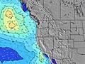 | 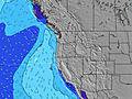 | 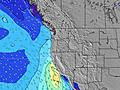 | 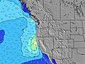 | 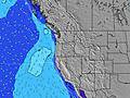 | ||||||||||||||
Wave Height (m) Direction Period (s) | WNW 9 | WNW 9 | NW 8 | WNW 8 | WNW 8 | WNW 8 | WNW 9 | WNW 9 | SW 14 | WNW 8 | NNW 5 | WNW 7 | NNW 6 | NNW 6 | NNW 7 | NNW 7 | NNW 7 | NNW 8 | NNW 8 | NNW 8 | NNW 8 |
Wave Graph | |||||||||||||||||||||
222 | 186 | 201 | 86 | 75 | 58 | 124 | 141 | 164 | 116 | 85 | 117 | 248 | 460 | 570 | 669 | 990 | 838 | 960 | 1457 | 1204 | |
Wind (km/h) | |||||||||||||||||||||
Wind State on-shore cross-onshore cross-shore cross-offshore off-shore glassy | cross-on | cross-on | cross-off | cross | cross | cross-off | cross-on | cross-on | cross-off | cross-on | cross | cross-off | cross | cross | cross-off | cross | cross | cross-off | cross | cross | cross-off |
High Tide | 1:28PM2.31m | 00:16AM2.80m | 1:56PM2.38m | 00:55AM2.75m | 2:23PM2.45m | 1:35AM2.65m | 2:50PM2.52m | 2:18AM2.51m | 3:18PM2.59m | 3:05AM2.34m | 3:47PM2.65m | 4:00AM2.17m | 4:22PM2.70m | ||||||||
Low Tide | 6:26PM1.49m | 7:17AM0.32m | 7:08PM1.41m | 7:48AM0.38m | 7:50PM1.32m | 8:17AM0.49m | 8:33PM1.22m | 8:46AM0.65m | 9:20PM1.12m | 9:15AM0.83m | 10:12PM1.02m | 9:48AM1.03m | 11:10PM0.91m | ||||||||
6:05 | — | — | 6:07 | — | — | 6:07 | — | — | 6:09 | — | — | 6:09 | — | — | 6:11 | — | — | 6:11 | — | — | |
— | 8:40 | — | — | 8:39 | — | — | 8:38 | — | — | 8:37 | — | — | 8:36 | — | — | 8:35 | — | — | 8:34 | — | |
mm | — | — | — | — | — | — | — | — | — | — | — | — | — | — | — | — | — | — | — | — | — |
Temp °C | 18 | 20 | 16 | 20 | 21 | 19 | 22 | 22 | 19 | 21 | 22 | 17 | 20 | 22 | 17 | 22 | 24 | 19 | 24 | 25 | 20 |
Feels °C | 16 | 17 | 14 | 16 | 17 | 15 | 19 | 19 | 16 | 19 | 19 | 13 | 15 | 16 | 12 | 16 | 17 | 14 | 19 | 20 | 16 |
Swell 1 Height (m) Direction Period (s) | WNW 9 | WNW 9 | NW 8 | SSW 16 | SSW 15 | SSW 15 | WNW 9 | WNW 9 | WNW 8 | WNW 8 | WNW 8 | WNW 7 | SW 14 | SSW 14 | SW 13 | SW 13 | SW 16 | SW 16 | SW 16 | SW 15 | SW 15 |
222 | 186 | 201 | 512 | 414 | 275 | 124 | 141 | 119 | 116 | 67 | 117 | 92 | 71 | 45 | 44 | 41 | 41 | 40 | 83 | 34 | |
Swell 2 Height (m) Direction Period (s) | SSW 16 | SSW 16 | SSW 16 | WNW 8 | WNW 8 | WNW 8 | SSW 14 | SW 14 | SW 14 | SSW 14 | SSW 14 | SSW 14 | S 13 | S 13 | SW 18 | SW 17 | SW 13 | SSW 12 | SSW 12 | SSW 12 | S 14 |
726 | 635 | 532 | 86 | 75 | 58 | 268 | 214 | 164 | 134 | 134 | 134 | 32 | 28 | 49 | 47 | 27 | 15 | 14 | 14 | 16 | |
Swell 3 Height (m) Direction Period (s) | SW 11 | S 18 | S 18 | S 16 | S 16 | S 16 | S 15 | S 15 | S 14 | S 13 | S 13 | S 13 | SW 19 | SW 18 | S 12 | S 12 | S 16 | S 12 | S 15 | S 15 | SSW 12 |
33 | 99 | 154 | 81 | 127 | 186 | 106 | 104 | 103 | 14 | 56 | 30 | 14 | 49 | 25 | 11 | 5 | 3 | 18 | 17 | 14 | |
Wind waves Height (m) Direction Period (s) | NNW 4 | NNW 4 | — | NNW 4 | NNW 4 | N 4 | NNW 4 | NNW 5 | N 4 | N 3 | NNW 5 | N 5 | NNW 6 | NNW 6 | NNW 7 | NNW 7 | NNW 7 | NNW 8 | NNW 8 | NNW 8 | NNW 8 |
25 | 31 | — | 22 | 43 | 15 | 29 | 54 | 10 | 5 | 85 | 83 | 248 | 460 | 570 | 669 | 990 | 838 | 960 | 1457 | 1204 | |
Nearest Offshore or Glassy | |||||||||||||||||||||
Distance (km) | 485 | 657 | 29 | 91 | 657 | 29 | 489 | 657 | 29 | 540 | 657 | 76 | 485 | 658 | 76 | 411 | 287 | 76 | 412 | 287 | 29 |
Best forecast wave conditions in South Oregon | |||||||||||||||||||||
Best forecast wave conditions in United States | |||||||||||||||||||||
Header Global | |||||||||||||||||||||
- Map Icons:
 Break
Break Live Wave Height (m)
 Live Wind Speed (km/h)
 Surf Rating (10 Max)
 Ocean Swells (m)
- Wind Speed (km/h)


FREE! Surf-Forecast.com widget for your website
The surf report / weather widget below is available to embed on third party websites free of charge and provides a summary of our Frankport surf forecast. Simply grab the html code snippet that we provide and paste it into your own site. You can choose your preferred language and metric/imperial units for the surf forecast feed to suit users of your site. Click here to get the code.
Information about the Frankport Surf forecast
The above surf forecast table for Frankport provides essential information for determining whether the surfing conditions will be good over the next 16 days. A general guide to surfing at Frankport can be found by selecting the local surf guide option on the grey menu. Our Frankport surf forecast is unique since it includes wave energy (power) that defines the real feel of the surf rather than just the height or the period. If you surf the same spot (Frankport) regularly then make a mental note of the wave energy from the surf forecast table each time you go. Very soon you may start to choose your surf days based on the wave energy alone combined with our forecast of favourable offshore wind conditions. Our star ratings will help here and of course you will also find the usual wave height and period predictions on our surf forecasts as well as a full break down of the swell components under our advanced users option (to reveal that, click the little Einstein character under the tide times).
Further information to help with frequently asked questions about our surf forecast for Frankport may be found under the help tab on the top menu and also by moving your mouse over the question marks on the surf forecast table itself. Please always bear in mind that the forecast is for near-shore open water and local factors at each surf break influence the actual breaking wave height, such as the beach / reef profile, water depths offshore and shelter.
Frankport is 89 km (55 miles) from Coos Bay. If you plan a vacation in South Oregon, look for hotels and other accommodation in Coos Bay. Coos Bay has rooms for a wide range of budgets as well as car hire and transport links.
 Nearest