

Surf Forecasts:

Zeneta surf forecast from 29 Jul 2026:
- Best quality surf: Saturday 1 Aug, 10PM (local time) - 3.5ft (1.0m), 7s period, NNW swell with cross-offshore winds.
- Most powerful swell: Wednesday 29 Jul, 4PM (local time) - 3.5ft (1.0m), 10s period, NNW swell with 204 kJ wave energy.
- Next surfable swell (1★+): Saturday 1 Aug, 10PM (local time) - 3.5ft (1.0m), 7s period with NNW swell.
Best Forecast Surf Conditions for Zeneta this week:
The surf forecast for Zeneta over the next 16 days: The first swell (rated 1 star or higher) is forecast to arrive on Saturday (Aug 01) at 10PM. The primary swell is predicted to be 1.0m and 7s period with a secondary swell of 0.6m and 9s. The wind is predicted to be cross-offshore as the swell arrives.
The most powerful waves expected at Zeneta in the next 16 days are 1.0m 10s and forecast to arrive on Wednesday (Jul 29) at 4PM. Winds are predicted to be cross-onshore at the time the swell arrives.
| Wave Type | Time (+01) & Date | Wave Height & Period |
|---|---|---|
| Next good surf (1 star+) | 10PM (Sat 1st Aug) | 3.5ft (1.0m) 7s |
| Best Surf | 10PM (Sat 1st Aug) | 3.5ft (1.0m) 7s |
| Most Powerful | 4PM (Wed 29th Jul) | 3.5ft (1.0m) 10s |
Table - best surf conditions forecast for Zeneta over the next 16 days.
The Lowdown
Alright folks, Rusty here. Let’s get into it. We’re looking at a pretty bleak stretch for Zeneta. The whole 16-day window is basically a write-off for decent paddle surfing. The wind is almost always coming from the wrong direction, messing up what little swell there is.
First up, Wednesday the 29th. We’ve got a small 3ft swell from the NNW with a period of 10 seconds, but the wind is a cross-onshore breeze from the NNE. The water is sitting at 69°, which is a bit colder than normal for this time of year. The combined wave energy is moderate at best (194), but the conditions are poor – just light cross-onshore chop. It’s not gonna be any fun.
That pattern just keeps on rolling. Through the rest of July and into the first week of August, we’re looking at swell heights mostly between 3ft and 4ft, but the wind is relentless. It’s either a cross-onshore or a cross-shore breeze from the north or northeast, keeping the surface messy and choppy. The wave energy fluctuates between weak (73) and moderate (219), but the “poor surf conditions” tag is a constant. There’s a brief moment of “marginal” surf on Thursday the 6th of August with a 4ft swell, but the wind is still cross-onshore, so it’s not a day to get excited about.
Even as we get into the second week, the story doesn’t change. Swell builds a little, with a 5ft NNW swell on Sunday the 9th of August, and the combined energy is strong (349). But the wind is a moderate cross-shore, which is just going to create a cross-chop. By Tuesday the 11th, the period stretches to 9 seconds, which is a little better, and the wind goes cross-shore, giving a slight cross-chop. It’s still a marginal call at best, not a standout.
Honestly, there’s no standout day here. The wind is the enemy the whole time. For a break like Zeneta, which is a consistent spot, having this long a run of poor conditions is a real bummer. The only thing worth noting is that if you’re into kitesurfing, the combination of onshore wind and small to moderate swell might actually be more interesting than trying to paddle out. But for us surfers? Keep your board in the car. The forecasts can change, but right now, there’s nothing to recommend.
Rusty, out.
Short Range ForecastMostly dry. Warm (max 29°C on Fri night, min 20°C on Wed night). Wind will be generally light. | Days 4-6 Weather SummaryMostly dry. Warm (max 32°C on Sat afternoon, min 21°C on Mon night). Wind will be generally light. | ||||||||||||||||||||
Wednesday 29 | Thursday 30 | Friday 31 | Saturday 1 | Sunday 2 | Monday 3 | Tuesday 4 | |||||||||||||||
AM | PM | Night | AM | PM | Night | AM | PM | Night | AM | PM | Night | AM | PM | Night | AM | PM | Night | AM | PM | Night | |
Swell Height Map | 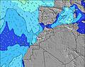 | 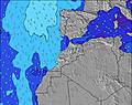 | 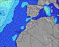 | 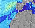 | 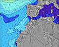 | 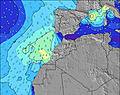 | 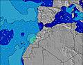 | ||||||||||||||
Wave Height (m) Direction Period (s) | NNW 10 | NNW 10 | NNW 9 | NNW 5 | NNW 6 | NNW 6 | NW 7 | NNW 7 | NNW 7 | NNW 7 | NNW 7 | NNW 7 | NNW 6 | NNW 6 | NNW 6 | NNW 6 | NNW 6 | NNW 5 | NNW 5 | N 5 | WNW 8 |
Wave Graph | |||||||||||||||||||||
182 | 204 | 55 | 33 | 48 | 107 | 135 | 151 | 113 | 85 | 85 | 102 | 114 | 90 | 68 | 55 | 58 | 36 | 39 | 34 | 48 | |
Wind (km/h) | |||||||||||||||||||||
Wind State on-shore cross-onshore cross-shore cross-offshore off-shore glassy | cross-on | cross-on | cross | cross-on | cross-on | cross-on | cross | cross-on | cross | cross | cross-on | cross-on | cross-on | cross-on | cross | cross-on | cross-on | cross | cross | cross-on | cross-on |
High Tide | 3:16PM3.39m | 3:37AM3.19m | 3:49PM3.47m | 4:09AM3.25m | 4:22PM3.51m | 4:41AM3.27m | 4:54PM3.51m | 5:14AM3.26m | 5:29PM3.47m | 5:50AM3.21m | 6:06PM3.37m | 6:31AM3.14m | 6:49PM3.23m | ||||||||
Low Tide | 9:32PM0.92m | 9:37AM0.98m | 10:05PM0.87m | 10:09AM0.93m | 10:37PM0.84m | 10:42AM0.92m | 11:10PM0.86m | 11:16AM0.94m | 11:45PM0.91m | 11:53AM1.01m | 00:23AM1.00m | 12:35PM1.12m | 1:07AM1.13m | ||||||||
6:39 | — | — | 6:41 | — | — | 6:41 | — | — | 6:41 | — | — | 6:43 | — | — | 6:43 | — | — | 6:43 | — | — | |
— | 8:32 | — | — | 8:31 | — | — | 8:31 | — | — | 8:30 | — | — | 8:30 | — | — | 8:29 | — | — | 8:28 | — | |
mm | — | — | — | — | — | — | — | — | — | — | — | — | — | — | — | — | — | — | — | — | — |
Temp °C | 23 | 23 | 21 | 23 | 24 | 23 | 27 | 27 | 29 | 31 | 32 | 28 | 28 | 27 | 24 | 25 | 25 | 23 | 24 | 24 | 22 |
Feels °C | 24 | 23 | 22 | 23 | 24 | 24 | 26 | 27 | 29 | 29 | 30 | 30 | 28 | 26 | 25 | 24 | 24 | 23 | 24 | 24 | 23 |
Swell 1 Height (m) Direction Period (s) | NNW 10 | WNW 11 | NNW 5 | NNW 5 | NW 10 | NNW 6 | NW 7 | NNW 7 | NNW 7 | NNW 7 | WNW 9 | WNW 9 | NNW 6 | WNW 9 | NNW 6 | NNW 6 | WNW 10 | NNW 5 | NNW 5 | WNW 9 | WNW 8 |
182 | 12 | 36 | 33 | 24 | 107 | 135 | 151 | 113 | 85 | 65 | 58 | 114 | 44 | 68 | 55 | 36 | 36 | 39 | 32 | 48 | |
Swell 2 Height (m) Direction Period (s) | WNW 8 | NW 8 | NNW 9 | NNW 9 | NNW 8 | WNW 10 | — | W 13 | WNW 11 | WNW 10 | — | WNW 9 | WNW 9 | NNW 9 | WNW 8 | WNW 10 | — | WNW 9 | WNW 9 | — | NW 5 |
7 | 3 | 55 | 30 | 14 | 9 | — | 3 | 12 | 54 | — | 62 | 44 | 7 | 39 | 38 | — | 32 | 33 | — | 11 | |
Swell 3 Height (m) Direction Period (s) | NW 12 | — | WNW 11 | WNW 10 | NW 10 | NW 8 | — | — | — | — | — | — | N 9 | — | NW 8 | — | — | — | — | — | — |
5 | — | 11 | 10 | 24 | 3 | — | — | — | — | — | — | 2 | — | 3 | — | — | — | — | — | — | |
Wind waves Height (m) Direction Period (s) | — | NNW 10 | — | — | NNW 6 | — | NNE 5 | NNE 5 | — | — | NNW 7 | NNW 7 | — | NNW 6 | — | — | NNW 6 | — | — | N 5 | N 5 |
— | 204 | — | — | 48 | — | 10 | 2 | — | — | 85 | 102 | — | 90 | — | — | 58 | — | — | 34 | 21 | |
Nearest Offshore or Glassy | |||||||||||||||||||||
Distance (km) | 391 | 1138 | 33 | 391 | 894 | 33 | 23 | 425 | 23 | 57 | 732 | 91 | 390 | 886 | 33 | 91 | 870 | 57 | 23 | 396 | 347 |
Best forecast wave conditions in Rabat to Casblanca | |||||||||||||||||||||
Best forecast wave conditions in Morocco | |||||||||||||||||||||
Header Global | |||||||||||||||||||||
- Map Icons:
 Break
Break Live Wave Height (m)
 Live Wind Speed (km/h)
 Surf Rating (10 Max)
 Ocean Swells (m)
- Wind Speed (km/h)


FREE! Surf-Forecast.com widget for your website
The surf report / weather widget below is available to embed on third party websites free of charge and provides a summary of our Zeneta surf forecast. Simply grab the html code snippet that we provide and paste it into your own site. You can choose your preferred language and metric/imperial units for the surf forecast feed to suit users of your site. Click here to get the code.
Information about the Zeneta Surf forecast
The above surf forecast table for Zeneta provides essential information for determining whether the surfing conditions will be good over the next 16 days. A general guide to surfing at Zeneta can be found by selecting the local surf guide option on the grey menu. Our Zeneta surf forecast is unique since it includes wave energy (power) that defines the real feel of the surf rather than just the height or the period. If you surf the same spot (Zeneta) regularly then make a mental note of the wave energy from the surf forecast table each time you go. Very soon you may start to choose your surf days based on the wave energy alone combined with our forecast of favourable offshore wind conditions. Our star ratings will help here and of course you will also find the usual wave height and period predictions on our surf forecasts as well as a full break down of the swell components under our advanced users option (to reveal that, click the little Einstein character under the tide times).
Further information to help with frequently asked questions about our surf forecast for Zeneta may be found under the help tab on the top menu and also by moving your mouse over the question marks on the surf forecast table itself. Please always bear in mind that the forecast is for near-shore open water and local factors at each surf break influence the actual breaking wave height, such as the beach / reef profile, water depths offshore and shelter.
Zeneta is 9 km (6 miles) from the city of Casablanca. If you plan a holiday in Rabat to Casblanca, look for hotels and other accommodation in Casablanca. Casablanca has rooms for a wide range of budgets as well as car hire and transport links.
 Nearest