

Surf Forecasts:

Winki Pop surf forecast from 3 Aug 2026:
- Best quality surf: Monday 10 Aug, 4PM (local time) - 16ft (5.0m), 16s period, WSW swell with offshore winds.
- Most powerful swell: Monday 10 Aug, 4PM (local time) - 16ft (5.0m), 16s period, WSW swell with 12,645 kJ wave energy.
- Next surfable swell (1★+): Tuesday 4 Aug, 4AM (local time) - 3.5ft (1.1m), 12s period with SW swell.
Best Forecast Surf Conditions for Winki Pop this week:
The surf forecast for Winki Pop over the next 16 days: The first swell (rated 1 star or higher) is forecast to arrive on Tuesday (Aug 04) at 4AM. The primary swell is predicted to be 1.1m and 12s period with a secondary swell of 0.5m and 17s. The wind is predicted to be offshore as the swell arrives.
The most powerful waves expected at Winki Pop in the next 16 days are 5.0m 16s and forecast to arrive on Monday (Aug 10) at 4PM. Winds are predicted to be offshore at the time the swell arrives. The largest open ocean swell (not directed at the beach) is 1.1m 5s period and expected on Sunday (Aug 09) at 7AM.
| Wave Type | Time (AEST) & Date | Wave Height & Period |
|---|---|---|
| Next good surf (1 star+) | 4AM (Tue 4th Aug) | 3.5ft (1.1m) 12s |
| Best Surf | 4PM (Mon 10th Aug) | 16ft (5.0m) 16s |
| Most Powerful | 4PM (Mon 10th Aug) | 16ft (5.0m) 16s |
Table - best surf conditions forecast for Winki Pop over the next 16 days.
The Lowdown
Alright, let’s get into it. Gotta tell ya, the next couple of days are a bit of a mixed bag, but we’ve got some serious firepower lined up if you’re patient. The real prize is sitting deep in the second week, but there’s enough to keep you interested before then.
We start off Tuesday the 4th at Winki Pop, a reef and point setup. The morning brings a 4ft SW swell, period 12 seconds, with a moderate offshore breeze from the WNW. The combined energy is moderate at 476, and it’s clean. It’s a solid start, but the afternoon turns a bit ugly with a risk of thunderstorms and a cross-off wind, making it marginal. Wednesday the 5th is a step up in size, 6ft SW swell with a 14-second period, and the wind is a gentle cross-off. The energy jumps right up to 1721, but the score says conditions are still a bit questionable. Not quite the cleanest.
Thursday the 6th drops right off. Swell bottoms out to 2ft, and while the morning is clean with a gentle offshore, the energy is weak at 213. Friday the 7th is a little better, 3ft SW swell with a 16-second period, light cross-off wind, and energy at 524, but it’s nothing to write home about. Saturday the 8th and Sunday the 9th are pretty ordinary, with onshore winds and fresh breezes making a mess of things. Best to give those a miss.
Now, hold onto your board. Monday the 10th is where it gets interesting. The afternoon is the standout for the whole forecast. We’re looking at a massive 16ft SW swell, 16-second period, with a beautiful moderate offshore wind from the WNW. The combined energy is a staggering 15973, which is exceptional. This is for expert surfers only; it’s way too big for anyone else. The rip will be pulling hard, and those sets will be packing serious punch. If you’ve got the skills and the nerve, this is the session.
The 16-second period means this is a proper groundswell, and it’ll be better if it lines up on the point. The wind is offshore, so expect some clean, heavy, powerful lines. This is a true blue standout.
The following days stay solid. Tuesday the 11th sees 6ft SW swell, and Wednesday the 12th has 8ft with a 16-second period and a gentle cross-off wind. The energy is 2935, excellent for experienced surfers. Thursday the 13th is another big day, 12ft SSW swell, 16-second period, and a gentle offshore from the NW. The energy is 7178, again for experts only. That’s a solid run of swell.
We get a bit of a breather towards the end of the week. Friday the 14th is 6ft, and the wind is light, but the afternoon gets a bit messy with a cross-onshore. Saturday the 15th is a dream. The afternoon is glassy, with a 4ft SW swell and a 15-second period. The energy is 681, and it’s expecting very good conditions. That’s a lovely clean session for all comers.
Sunday the 16th and Monday the 17th are smaller, with offshore winds and clean conditions, but the energy drops off. Tuesday the 18th is a write-off with onshore winds. Then we finish on Wednesday the 19th, with a glassy morning, 5ft SW swell, 15-second period, and energy at 871. Expect very good conditions again. But honestly, the big Monday on the 10th is the one you want to circle.
Rusty.
Short Range ForecastLight rain (total 7mm), mostly falling on Mon night. Very mild (max 13°C on Wed afternoon, min 7°C on Mon night). Wind will be generally light. | Days 5-7 Weather SummaryModerate rain (total 13mm), heaviest on Sun morning. Very mild (max 16°C on Sat morning, min 9°C on Sun afternoon). Winds increasing (light winds from the NW on Fri afternoon, fresh winds from the N by Sat night). | ||||||||||||||||||
Tuesday 4 | Wednesday 5 | Thursday 6 | Friday 7 | Saturday 8 | Sunday 9 | ||||||||||||||
Night | AM | PM | Night | AM | PM | Night | AM | PM | Night | AM | PM | Night | AM | PM | Night | AM | PM | Night | |
Swell Height Map |  |  |  |  | 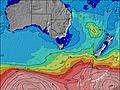 | 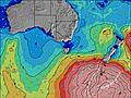 | 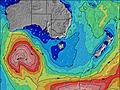 | ||||||||||||
Wave Height (m) Direction Period (s) | WSW 13 | SW 12 | SW 12 | SW 10 | SW 14 | SW 14 | SW 17 | SW 16 | SW 16 | SW 18 | SW 16 | SW 15 | SW 18 | SW 16 | SW 16 | SW 15 | SW 14 | SW 14 | SW 16 |
Wave Graph | |||||||||||||||||||
2402 | 409 | 644 | 577 | 1107 | 810 | 147 | 203 | 198 | 300 | 480 | 313 | 588 | 574 | 553 | 309 | 251 | 269 | 651 | |
Wind (km/h) | |||||||||||||||||||
Wind State on-shore cross-onshore cross-shore cross-offshore off-shore glassy | cross-off | off | cross-off | cross-off | cross-off | cross-off | cross-off | off | cross-off | cross-off | cross-off | cross-off | cross-off | cross-off | cross-off | cross-off | cross-off | cross-off | cross-off |
High Tide | 3:11AM1.69m | 3:22PM1.87m | 3:50AM1.75m | 3:48PM1.85m | 4:31AM1.80m | 4:16PM1.83m | 5:15AM1.81m | 4:48PM1.80m | 6:04AM1.79m | 5:24PM1.75m | 7:02AM1.74m | 6:09PM1.69m | |||||||
Low Tide | 9:09AM0.45m | 9:40PM0.35m | 9:45AM0.51m | 10:11PM0.26m | 10:22AM0.60m | 10:45PM0.19m | 11:02AM0.70m | 11:24PM0.14m | 11:46AM0.81m | 00:11AM0.13m | 12:38PM0.93m | 1:07AM0.16m | |||||||
— | 7:22 | — | — | 7:20 | — | — | 7:20 | — | — | 7:18 | — | — | 7:16 | — | — | 7:16 | — | — | |
— | — | 5:36 | — | — | 5:37 | — | — | 5:37 | — | — | 5:37 | — | — | 5:38 | — | — | 5:39 | — | |
mm | 2 | 2 | 2 | 1 | — | — | — | — | — | — | — | — | — | — | 2 | 5 | 4 | 2 | 2 |
Temp °C | 9 | 12 | 12 | 10 | 12 | 13 | 11 | 12 | 12 | 11 | 12 | 13 | 12 | 16 | 13 | 13 | 12 | 11 | 10 |
Feels °C | 5 | 7 | 7 | 6 | 8 | 9 | 8 | 7 | 9 | 8 | 8 | 9 | 9 | 10 | 7 | 6 | 6 | 4 | 3 |
Swell 1 Height (m) Direction Period (s) | SW 13 | SW 12 | SW 16 | SW 10 | SSW 15 | SSW 9 | SW 13 | SW 16 | SW 16 | SW 18 | SW 16 | SW 15 | SW 18 | SW 16 | SW 16 | SW 15 | SW 14 | SW 14 | SW 16 |
352 | 409 | 119 | 229 | 455 | 121 | 106 | 203 | 198 | 300 | 480 | 313 | 588 | 574 | 553 | 309 | 251 | 269 | 651 | |
Swell 2 Height (m) Direction Period (s) | WSW 13 | SW 16 | S 16 | SW 15 | SW 20 | SW 14 | SW 17 | S 5 | SW 6 | SSW 5 | S 6 | S 7 | S 7 | S 7 | S 6 | — | — | NNE 5 | SW 20 |
120 | 67 | 5 | 54 | 98 | 167 | 147 | 5 | 9 | 24 | 26 | 32 | 24 | 8 | 3 | — | — | 2 | 251 | |
Swell 3 Height (m) Direction Period (s) | SW 17 | N 4 | — | SW 21 | SW 11 | SW 18 | SW 8 | S 16 | S 8 | SW 14 | SW 6 | SW 19 | — | — | — | — | — | NE 6 | — |
148 | 2 | — | 109 | 61 | 166 | 32 | 5 | 1 | 73 | 18 | 231 | — | — | — | — | — | 1 | — | |
Wind waves Height (m) Direction Period (s) | WSW 13 | WNW 3 | SW 12 | SW 10 | SW 14 | SW 14 | — | NW 2 | W 2 | SW 5 | — | — | — | ESE 7 | NNE 4 | NNE 4 | NNE 5 | WNW 3 | NW 3 |
2402 | 3 | 644 | 577 | 1107 | 810 | — | 1 | 1 | 56 | — | — | — | 15 | 10 | 17 | 52 | 5 | 8 | |
Nearest Offshore or Glassy | |||||||||||||||||||
Distance (km) | 6 | 0 | 11 | 6 | 6 | 6 | 0 | 0 | 6 | 0 | 0 | 0 | 0 | 10 | 30 | 169 | 524 | 235 | 358 |
Best forecast wave conditions in Torquay | |||||||||||||||||||
Best forecast wave conditions in Australia | |||||||||||||||||||
Header Global | |||||||||||||||||||
- Map Icons:
 Break
Break Live Wave Height (m)
 Live Wind Speed (km/h)
 Surf Rating (10 Max)
 Ocean Swells (m)
- Wind Speed (km/h)
Latest Updates


FREE! Surf-Forecast.com widget for your website
The surf report / weather widget below is available to embed on third party websites free of charge and provides a summary of our Winki Pop surf forecast. Simply grab the html code snippet that we provide and paste it into your own site. You can choose your preferred language and metric/imperial units for the surf forecast feed to suit users of your site. Click here to get the code.
Information about the Winki Pop Surf forecast
The above surf forecast table for Winki Pop provides essential information for determining whether the surfing conditions will be good over the next 16 days. A general guide to surfing at Winki Pop can be found by selecting the local surf guide option on the grey menu. Our Winki Pop surf forecast is unique since it includes wave energy (power) that defines the real feel of the surf rather than just the height or the period. If you surf the same spot (Winki Pop) regularly then make a mental note of the wave energy from the surf forecast table each time you go. Very soon you may start to choose your surf days based on the wave energy alone combined with our forecast of favourable offshore wind conditions. Our star ratings will help here and of course you will also find the usual wave height and period predictions on our surf forecasts as well as a full break down of the swell components under our advanced users option (to reveal that, click the little Einstein character under the tide times).
Further information to help with frequently asked questions about our surf forecast for Winki Pop may be found under the help tab on the top menu and also by moving your mouse over the question marks on the surf forecast table itself. Please always bear in mind that the forecast is for near-shore open water and local factors at each surf break influence the actual breaking wave height, such as the beach / reef profile, water depths offshore and shelter.
Winki Pop is 25 km (16 miles) from the city of Geelong. If you plan a holiday in Torquay, look for hotels and other accommodation in Geelong. Geelong has rooms for a wide range of budgets as well as car hire and transport links.
 Nearest