

Surf Forecasts:

Point Lonsdale surf forecast from 1 Aug 2026:
- Best quality surf: Saturday 1 Aug, 4PM (local time) - 4.5ft (1.3m), 17s period, SW swell with offshore winds.
- Most powerful swell: Saturday 1 Aug, 10PM (local time) - 7ft (2.1m), 16s period, SW swell with 2,220 kJ wave energy.
- Next surfable swell (1★+): Saturday 1 Aug, 4PM (local time) - 4.5ft (1.3m), 17s period with SW swell.
Best Forecast Surf Conditions for Point Lonsdale this week:
The surf forecast for Point Lonsdale over the next 16 days: The first swell (rated 1 star or higher) is forecast to arrive on Saturday (Aug 01) at 4PM. The primary swell is predicted to be 1.3m and 17s period with a secondary swell of 1.3m and 13s. The wind is predicted to be offshore as the swell arrives.
The most powerful waves expected at Point Lonsdale in the next 16 days are 2.1m 16s and forecast to arrive on Saturday (Aug 01) at 10PM. Winds are predicted to be cross-offshore at the time the swell arrives. The largest open ocean swell (not directed at the beach) is 0.9m 4s period and expected on Monday (Aug 03) at 1AM.
| Wave Type | Time (AEST) & Date | Wave Height & Period |
|---|---|---|
| Next good surf (1 star+) | 4PM (Sat 1st Aug) | 4.5ft (1.3m) 17s |
| Best Surf | 4PM (Sat 1st Aug) | 4.5ft (1.3m) 17s |
| Most Powerful | 10PM (Sat 1st Aug) | 7ft (2.1m) 16s |
Table - best surf conditions forecast for Point Lonsdale over the next 16 days.
The Lowdown
G’day, Rusty here, and I’ve had a look at the surf coming up for Point Lonsdale. This is a beach and reef set-up that’s exposed to the SW, and it’s a fairly consistent spot, so it usually doesn’t stay flat for long. The good news is there’s some decent swell on the cards, but we’ve got to work through a fair bit of wind and chop to get to the real gems.
Right now, the water’s at 55.8°, which is pretty much bang on average for the time of year, so no nasty surprises there.
The first real standout is this Saturday (1st August). The morning kicks off with a clean 3.9ft SW swell (12-second period) and a gentle offshore breeze from the NNE. The combined swell energy is a solid 821 (moderate energy), and it’s going to be smooth and glassy. The afternoon holds up even better, with the swell bumping up to 4.3ft, a very long-period 17-second groundswell from the SW, and a moderate offshore wind. The energy jumps to 1463 (moderate–strong energy). This is prime surf for experienced surfers, but there’s a catch—crowds are often an issue here, so get in early for a chance at a peak. The long period means the waves will be well-shaped, good for the reef sections, but keep an eye on the tide.
Sunday (2nd August) is still on the cards, but it’s a step down. The morning has a 5.6ft SW swell (16-second period) with a fresh offshore wind from the north. The energy is 1537 (strong). That’s a bit too much punch for beginners, and the fresh breeze will keep things a little wild. The afternoon is similar, 5.2ft, still offshore, but the conditions are marginal, so it’s a maybe.
Then we hit a rough patch. From Monday (3rd August) through to Thursday (6th August), it’s pretty much a write-off. Cross-shore and onshore winds, rain, and lumpy, choppy surf. The swell drops to 3.3ft or less, and the energy fades. Thursday morning has just 2.6ft and a 381 (weak energy). Not worth paddling out.
But look, Friday (7th August) pulls us back. The morning is clear, with a light offshore breeze from the NW, and a 4.3ft SW swell (16-second period). The combined energy is 1081 (moderate–strong). The afternoon is even better: 4.6ft, 15-second period, with a light cross-offshore breeze from the ENE and energy of 1477. This is another excellent session for experienced surfers, clean and lined up. The long period will make the waves powerful, so it’s worth the paddle.
Saturday (8th August) is a bit of a tease. The swell is 4.3ft, with a fresh offshore wind, but the energy is down to 837 (moderate), and it’s marginal. The wind is strong from the north, and while it’s offshore, it’s hard work. By Sunday (9th August), the wind is howling at 25–28 mph from the NNE, and the swell is gutless at 3.3ft. The energy is only 361 (weak). That’s strong offshore and clean, but you’ll be paddling your heart out for nothing.
The next week gets messy again. Monday (10th August) through to Thursday (13th August) is mostly onshore, cross-onshore, or rain, with a mix of lumpy, choppy, and poor conditions. The swell does pick up big time on Tuesday (11th August) afternoon, with a 9.8ft WSW swell (14-second period) and a huge energy of 6060 (very strong). That’s a monster for experts only, but the wind is light cross-onshore, so it’s going to be messy and dangerous. The waves will be powerful but sloppy. For a beach and reef spot, that’s more kite-surfing territory than paddle surfing.
Wednesday (12th August) morning has 7.2ft SW swell (14 seconds) and 3206 energy (strong), but it’s cross-shore wind, so it’s lumpy. The afternoon ramps up to 8.2ft with a 17-second period and 4428 energy (very strong), but the wind swings to a fresh cross-onshore, making it poor. That’s all for the brave, and not really a recommendation.
The last few days of the outlook, Friday (14th August) to Saturday (15th August), are a bust. Onshore winds, rain, and dropping swell. Sunday (16th August) morning brings a little hope: 3.9ft SW swell (16-second period), light offshore wind from the east, and 705 energy (moderate). The conditions are clean, and it’s a very good session for the day. The afternoon, though, gets cross-onshore again, so call it a half-day.
So, what’s the
Short Range ForecastLight rain (total 8mm), mostly falling on Mon afternoon. Very mild (max 15°C on Sat afternoon, min 8°C on Sat morning). Winds increasing (light winds from the NNE on Sat morning, fresh winds from the WNW by Mon morning). | Days 4-6 Weather SummaryLight rain (total 6mm), mostly falling on Tue morning. Very mild (max 13°C on Tue afternoon, min 9°C on Thu night). Winds decreasing (fresh winds from the W on Tue morning, light winds from the NW by Thu night). | ||||||||||||||||||||
Saturday 1 | Sunday 2 | Monday 3 | Tuesday 4 | Wednesday 5 | Thursday 6 | Friday 7 | |||||||||||||||
AM | PM | Night | AM | PM | Night | AM | PM | Night | AM | PM | Night | AM | PM | Night | AM | PM | Night | AM | PM | Night | |
Swell Height Map |  |  |  | 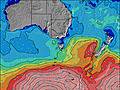 | 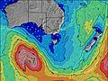 | 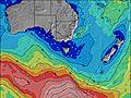 | 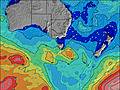 | ||||||||||||||
Wave Height (m) Direction Period (s) | SW 12 | SW 17 | SW 16 | SW 16 | SW 16 | SW 15 | SW 14 | SW 14 | SW 13 | SW 12 | SW 12 | SW 11 | SW 13 | SW 14 | SW 13 | SW 12 | SW 16 | SW 18 | SW 16 | SW 15 | SW 17 |
Wave Graph | |||||||||||||||||||||
437 | 918 | 2220 | 1446 | 1170 | 847 | 746 | 716 | 560 | 851 | 963 | 461 | 330 | 387 | 330 | 210 | 339 | 318 | 920 | 915 | 1399 | |
Wind (km/h) | |||||||||||||||||||||
Wind State on-shore cross-onshore cross-shore cross-offshore off-shore glassy | off | off | off | off | off | cross-off | cross | cross | cross | cross-on | cross-on | cross-on | cross-on | on | cross-on | cross-on | on | cross | cross-off | cross-off | off |
High Tide | 1:56PM1.42m | 1:38AM1.25m | 2:29PM1.44m | 2:26AM1.31m | 2:59PM1.45m | 3:11AM1.36m | 3:27PM1.45m | 3:56AM1.40m | 3:56PM1.46m | 4:42AM1.41m | 4:27PM1.45m | 5:30AM1.40m | 5:00PM1.44m | ||||||||
Low Tide | 8:05PM0.56m | 7:57AM0.29m | 8:39PM0.48m | 8:38AM0.32m | 9:12PM0.40m | 9:17AM0.38m | 9:45PM0.33m | 9:54AM0.45m | 10:21PM0.27m | 10:32AM0.54m | 10:59PM0.23m | 11:12AM0.63m | 11:43PM0.21m | ||||||||
7:22 | — | — | 7:22 | — | — | 7:20 | — | — | 7:20 | — | — | 7:18 | — | — | 7:18 | — | — | 7:16 | — | — | |
— | 5:31 | — | — | 5:32 | — | — | 5:34 | — | — | 5:35 | — | — | 5:36 | — | — | 5:36 | — | — | 5:37 | — | |
mm | — | — | — | — | — | 1 | — | 6 | 1 | 2 | 1 | — | 1 | 2 | — | — | — | — | — | — | — |
Temp °C | 12 | 15 | 12 | 14 | 15 | 12 | 12 | 11 | 10 | 12 | 13 | 11 | 12 | 12 | 11 | 12 | 12 | 12 | 10 | 12 | 11 |
Feels °C | 8 | 10 | 8 | 7 | 8 | 6 | 4 | 4 | 5 | 6 | 8 | 7 | 9 | 9 | 7 | 8 | 8 | 9 | 8 | 9 | 7 |
Swell 1 Height (m) Direction Period (s) | SW 12 | SW 17 | SW 16 | SW 16 | SW 16 | SW 15 | SW 14 | SW 14 | SW 13 | SW 12 | SW 15 | SW 11 | SW 13 | SW 14 | SW 13 | SW 12 | SW 16 | SW 15 | SW 16 | SW 15 | SW 17 |
437 | 918 | 2220 | 1446 | 1170 | 847 | 746 | 716 | 560 | 851 | 186 | 461 | 330 | 387 | 330 | 210 | 339 | 255 | 920 | 915 | 1399 | |
Swell 2 Height (m) Direction Period (s) | SW 17 | SW 13 | S 18 | SSW 16 | S 16 | S 15 | WSW 16 | S 14 | SW 7 | SW 16 | S 16 | SW 14 | SW 19 | SW 18 | S 6 | SW 16 | S 5 | SW 18 | WSW 20 | SW 19 | S 17 |
362 | 545 | 156 | 91 | 81 | 41 | 512 | 36 | 37 | 95 | 5 | 73 | 236 | 215 | 31 | 163 | 4 | 318 | 154 | 450 | 52 | |
Swell 3 Height (m) Direction Period (s) | S 17 | — | — | — | — | WSW 20 | S 14 | — | SW 17 | — | — | SW 21 | S 19 | S 18 | SW 18 | S 5 | SW 20 | S 8 | SW 7 | S 19 | — |
22 | — | — | — | — | 75 | 37 | — | 190 | — | — | 153 | 7 | 25 | 194 | 8 | 61 | 10 | 7 | 112 | — | |
Wind waves Height (m) Direction Period (s) | — | — | N 3 | NNE 4 | N 4 | NW 4 | WNW 4 | WSW 7 | — | SW 6 | SW 12 | S 6 | S 6 | S 6 | — | — | SSW 5 | — | — | — | — |
— | — | 5 | 10 | 9 | 21 | 30 | 164 | — | 98 | 963 | 53 | 76 | 60 | — | — | 9 | — | — | — | — | |
Nearest Offshore or Glassy | |||||||||||||||||||||
Distance (km) | 0 | 0 | 0 | 9 | 28 | 19 | 286 | 39 | 25 | 25 | 51 | 19 | 19 | 20 | 10 | 19 | 25 | 9 | 0 | 0 | 0 |
Best forecast wave conditions in Torquay | |||||||||||||||||||||
Best forecast wave conditions in Australia | |||||||||||||||||||||
Header Global | |||||||||||||||||||||
- Map Icons:
 Break
Break Live Wave Height (m)
 Live Wind Speed (km/h)
 Surf Rating (10 Max)
 Ocean Swells (m)
- Wind Speed (km/h)
Latest Updates


FREE! Surf-Forecast.com widget for your website
The surf report / weather widget below is available to embed on third party websites free of charge and provides a summary of our Point Lonsdale surf forecast. Simply grab the html code snippet that we provide and paste it into your own site. You can choose your preferred language and metric/imperial units for the surf forecast feed to suit users of your site. Click here to get the code.
Information about the Point Lonsdale Surf forecast
The above surf forecast table for Point Lonsdale provides essential information for determining whether the surfing conditions will be good over the next 16 days. A general guide to surfing at Point Lonsdale can be found by selecting the local surf guide option on the grey menu. Our Point Lonsdale surf forecast is unique since it includes wave energy (power) that defines the real feel of the surf rather than just the height or the period. If you surf the same spot (Point Lonsdale) regularly then make a mental note of the wave energy from the surf forecast table each time you go. Very soon you may start to choose your surf days based on the wave energy alone combined with our forecast of favourable offshore wind conditions. Our star ratings will help here and of course you will also find the usual wave height and period predictions on our surf forecasts as well as a full break down of the swell components under our advanced users option (to reveal that, click the little Einstein character under the tide times).
Further information to help with frequently asked questions about our surf forecast for Point Lonsdale may be found under the help tab on the top menu and also by moving your mouse over the question marks on the surf forecast table itself. Please always bear in mind that the forecast is for near-shore open water and local factors at each surf break influence the actual breaking wave height, such as the beach / reef profile, water depths offshore and shelter.
Point Lonsdale is 21 km (13 miles) from the city of Geelong. If you plan a holiday in Torquay, look for hotels and other accommodation in Geelong. Geelong has rooms for a wide range of budgets as well as car hire and transport links.
 Nearest