

Surf Forecasts:

Shacks surf forecast from 3 Aug 2026:
- Best quality surf: Wednesday 5 Aug, 5PM (local time) - 3.5ft (1.0m), 6s period, ENE swell with cross-offshore winds.
- Most powerful swell: Monday 3 Aug, 5PM (local time) - 6.5ft (2.0m), 6s period, ENE swell with 291 kJ wave energy.
- Next surfable swell (1★+): Wednesday 5 Aug, 5PM (local time) - 3.5ft (1.0m), 6s period with ENE swell.
Best Forecast Surf Conditions for Shacks this week:
The surf forecast for Shacks over the next 16 days: The first swell (rated 1 star or higher) is forecast to arrive on Wednesday (Aug 05) at 5PM. The primary swell is predicted to be 1.0m and 6s period with a secondary swell of 0.1m and 9s. Another secondary swell of 0.1m and 11s is also forecast. The wind is predicted to be cross-offshore as the swell arrives.
The most powerful waves expected at Shacks in the next 16 days are 2.0m 6s and forecast to arrive on Monday (Aug 03) at 5PM. Winds are predicted to be cross-shore at the time the swell arrives. The largest open ocean swell (not directed at the beach) is 1.7m 6s period and expected on Saturday (Aug 08) at 5PM.
| Wave Type | Time (AST) & Date | Wave Height & Period |
|---|---|---|
| Next good surf (1 star+) | 5PM (Wed 5th Aug) | 3.5ft (1.0m) 6s |
| Best Surf | 5PM (Wed 5th Aug) | 3.5ft (1.0m) 6s |
| Most Powerful | 5PM (Mon 3rd Aug) | 6.5ft (2.0m) 6s |
Table - best surf conditions forecast for Shacks over the next 16 days.
The Lowdown
Alright, Rusty here again. Let’s break it down in feet and Fahrenheit.
The 16-day window for Shacks is a real bummer. The water temp is around 84°F, which is about normal for this time of year, so nothing unusual there.
The whole run is plagued by a constant cross-shore wind from the ENE. The swell is coming from the same direction, so you get a lot of cross-chop and lumpy, bumpy conditions. The wave energy ranges from weak to moderate, but the quality is just poor. The swell period is short, mostly 6 to 8 seconds, so the waves are weak and choppy, with no real push.
From Monday the 3rd through the end of the first week, it’s the same old story: cross-shore wind, small to medium swell, but the surface is messy. The only tiny window of relief is Wednesday afternoon the 5th, when the wind turns slightly cross-off and the waves look clean. But the swell is only 3ft from the ENE with a short period, so it’s just surfable, nothing more.
In the second week, the swell picks up. Around Thursday the 13th, the swell hits 6ft in the morning, and by Friday the 14th it’s also 6ft from the E, with the wave energy getting strong. But the wind is still cross-shore, and the period is still short, so it’s going to be a lumpy, bumpy mess. The wind gets up to 22 mph in the afternoons, making it even worse. For a reef break, this onshore wind just ruins what could be a good wave.
The best of the second week is probably the Thursday morning the 13th or Friday morning the 14th. The swell is there, around 6ft from the ENE, with some energy, but the wind is a moderate breeze, so it’s cross-shore chop. Not ideal, but it’s the most size you’ll see.
For experienced surfers, you might find something to work with on the bigger days, but the swell over 5ft and the chop will be too much for beginners. The only real bright spot is that Wednesday afternoon the 5th, but it’s small and brief. For the rest of the time, the surf is poor, so maybe it’s time to break out the kiteboard – the wind is strong enough that this looks more interesting for kiting than paddle surfing.
Rusty.
Short Range ForecastModerate rain (total 11mm), heaviest on Wed afternoon. Warm (max 29°C on Mon morning, min 25°C on Wed night). Wind will be generally light. | Days 4-6 Weather SummaryLight rain (total 6mm), mostly falling on Thu afternoon. Warm (max 29°C on Thu morning, min 25°C on Thu night). Winds increasing (light winds from the ENE on Thu morning, fresh winds from the E by Sat night). | ||||||||||||||||||||
Monday 3 | Tuesday 4 | Wednesday 5 | Thursday 6 | Friday 7 | Saturday 8 | Sunday 9 | |||||||||||||||
AM | PM | Night | AM | PM | Night | AM | PM | Night | AM | PM | Night | AM | PM | Night | AM | PM | Night | AM | PM | Night | |
Swell Height Map |  |  |  | 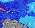 | 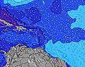 | 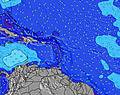 | 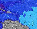 | ||||||||||||||
Wave Height (m) Direction Period (s) | ENE 7 | ENE 6 | E 6 | ENE 7 | N 10 | N 9 | ENE 7 | ENE 6 | E 11 | ENE 7 | ENE 6 | NE 9 | ENE 8 | ENE 8 | ENE 7 | ENE 7 | ENE 6 | NE 9 | NE 9 | NNE 11 | NE 9 |
Wave Graph | |||||||||||||||||||||
114 | 291 | 97 | 82 | 2 | 2 | 62 | 80 | 5 | 85 | 143 | 62 | 217 | 170 | 36 | 88 | 0 | 20 | 19 | 11 | 21 | |
Wind (km/h) | |||||||||||||||||||||
Wind State on-shore cross-onshore cross-shore cross-offshore off-shore glassy | cross | cross | cross-off | cross | cross | cross-off | cross | cross-off | cross-off | cross | cross | cross-off | cross | cross | cross-off | cross | cross | cross-off | cross | cross | cross-off |
High Tide | 11:36AM0.42m | 11:34PM0.40m | 12:29PM0.44m | 00:10AM0.36m | 1:26PM0.46m | 00:54AM0.31m | 2:30PM0.47m | 1:49AM0.28m | 3:36PM0.49m | 2:55AM0.27m | 4:42PM0.51m | 4:06AM0.27m | 5:46PM0.53m | ||||||||
Low Tide | 5:45PM0.15m | 5:57AM0.08m | 6:47PM0.17m | 6:34AM0.06m | 7:56PM0.18m | 7:20AM0.04m | 9:11PM0.18m | 8:16AM0.02m | 10:26PM0.18m | 9:21AM0.00m | 11:36PM0.17m | 10:28AM-0.01m | 00:35AM0.16m | ||||||||
6:05 | — | — | 6:05 | — | — | 6:07 | — | — | 6:07 | — | — | 6:07 | — | — | 6:07 | — | — | 6:07 | — | — | |
— | 7:01 | — | — | 7:00 | — | — | 7:00 | — | — | 7:00 | — | — | 7:00 | — | — | 6:59 | — | — | 6:59 | — | |
mm | — | — | — | — | 3 | 1 | — | 6 | 1 | — | 2 | — | — | — | 1 | 1 | 1 | 1 | — | 1 | — |
Temp °C | 29 | 29 | 28 | 29 | 29 | 27 | 29 | 28 | 28 | 29 | 29 | 28 | 28 | 29 | 27 | 29 | 29 | 28 | 30 | 28 | 27 |
Feels °C | 32 | 29 | 29 | 30 | 29 | 28 | 31 | 29 | 31 | 32 | 30 | 30 | 29 | 28 | 27 | 31 | 30 | 27 | 30 | 27 | 26 |
Swell 1 Height (m) Direction Period (s) | — | — | — | — | N 10 | N 9 | N 9 | N 9 | E 11 | E 10 | NNE 10 | NE 9 | E 9 | NE 9 | ENE 7 | NE 9 | — | NE 9 | NE 9 | NNE 11 | NE 9 |
— | — | — | — | 2 | 2 | 2 | 2 | 2 | 8 | 9 | 62 | 6 | 22 | 36 | 20 | — | 20 | 19 | 11 | 21 | |
Swell 2 Height (m) Direction Period (s) | — | — | — | — | — | — | N 12 | N 11 | NE 11 | NE 10 | — | E 9 | — | — | NE 9 | — | — | — | NE 12 | — | — |
— | — | — | — | — | — | 3 | 2 | 5 | 4 | — | 7 | — | — | 20 | — | — | — | 6 | — | — | |
Swell 3 Height (m) Direction Period (s) | — | — | — | — | — | — | — | E 12 | — | — | — | — | — | — | — | — | — | — | — | — | — |
— | — | — | — | — | — | — | 3 | — | — | — | — | — | — | — | — | — | — | — | — | — | |
Wind waves Height (m) Direction Period (s) | ENE 7 | ENE 6 | E 6 | ENE 7 | ENE 4 | ENE 5 | ENE 7 | ENE 6 | ENE 6 | ENE 7 | ENE 6 | ENE 5 | ENE 8 | ENE 8 | ENE 5 | ENE 7 | ENE 6 | ENE 6 | ENE 6 | ENE 6 | ENE 6 |
114 | 291 | 97 | 82 | 40 | 44 | 62 | 80 | 72 | 85 | 143 | 56 | 217 | 170 | 40 | 88 | 186 | 102 | 109 | 193 | 118 | |
Nearest Offshore or Glassy | |||||||||||||||||||||
Distance (km) | 4 | 22 | 25 | 747 | 459 | 108 | 284 | 0 | 4 | 4 | 257 | 40 | 8 | 879 | 40 | 4 | 459 | 40 | 634 | 634 | 233 |
Best forecast wave conditions in Puerto Rico | |||||||||||||||||||||
Best forecast wave conditions in Puerto Rico | |||||||||||||||||||||
Header Global | |||||||||||||||||||||
- Map Icons:
 Break
Break Live Wave Height (m)
 Live Wind Speed (km/h)
 Surf Rating (10 Max)
 Ocean Swells (m)
- Wind Speed (km/h)
Latest Updates


FREE! Surf-Forecast.com widget for your website
The surf report / weather widget below is available to embed on third party websites free of charge and provides a summary of our Shacks surf forecast. Simply grab the html code snippet that we provide and paste it into your own site. You can choose your preferred language and metric/imperial units for the surf forecast feed to suit users of your site. Click here to get the code.
Information about the Shacks Surf forecast
The above surf forecast table for Shacks provides essential information for determining whether the surfing conditions will be good over the next 16 days. A general guide to surfing at Shacks can be found by selecting the local surf guide option on the grey menu. Our Shacks surf forecast is unique since it includes wave energy (power) that defines the real feel of the surf rather than just the height or the period. If you surf the same spot (Shacks) regularly then make a mental note of the wave energy from the surf forecast table each time you go. Very soon you may start to choose your surf days based on the wave energy alone combined with our forecast of favourable offshore wind conditions. Our star ratings will help here and of course you will also find the usual wave height and period predictions on our surf forecasts as well as a full break down of the swell components under our advanced users option (to reveal that, click the little Einstein character under the tide times).
Further information to help with frequently asked questions about our surf forecast for Shacks may be found under the help tab on the top menu and also by moving your mouse over the question marks on the surf forecast table itself. Please always bear in mind that the forecast is for near-shore open water and local factors at each surf break influence the actual breaking wave height, such as the beach / reef profile, water depths offshore and shelter.
Shacks is 7 km (4 miles) from the city of Aguadilla. If you plan a holiday in Puerto Rico, look for hotels and other accommodation in Aguadilla. Aguadilla has rooms for a wide range of budgets as well as car hire and transport links.
 Nearest