

Surf Forecasts:

Porto Armando surf forecast from 24 Jul 2026:
- Best quality surf: Sunday 26 Jul, 2AM (local time) - 4.5ft (1.3m), 6s period, SSE swell with glassy winds.
- Most powerful swell: Sunday 26 Jul, 2AM (local time) - 4.5ft (1.3m), 6s period, SSE swell with 105 kJ wave energy.
- Next surfable swell (1★+): Sunday 26 Jul, 2AM (local time) - 4.5ft (1.3m), 6s period with SSE swell.
Best Forecast Surf Conditions for Porto Armando this week:
The surf forecast for Porto Armando over the next 16 days: The first swell (rated 1 star or higher) is forecast to arrive on Sunday (Jul 26) at 2AM. The primary swell is predicted to be 1.3m and 6s period with a secondary swell of 0.9m and 5s. The wind is predicted to be glassy as the swell arrives.
The most powerful waves expected at Porto Armando in the next 16 days are 1.3m 6s and forecast to arrive on Sunday (Jul 26) at 2AM. Winds are predicted to be glassy at the time the swell arrives. The largest open ocean swell (not directed at the beach) is 0.7m 7s period and expected on Sunday (Jul 26) at 11PM.
| Wave Type | Time (CEST) & Date | Wave Height & Period |
|---|---|---|
| Next good surf (1 star+) | 2AM (Sun 26th Jul) | 4.5ft (1.3m) 6s |
| Best Surf | 2AM (Sun 26th Jul) | 4.5ft (1.3m) 6s |
| Most Powerful | 2AM (Sun 26th Jul) | 4.5ft (1.3m) 6s |
Table - best surf conditions forecast for Porto Armando over the next 16 days.
The Lowdown
Yo, Rusty here. I’ve been staring at the charts for Porto Armando, and I gotta be straight with you – it’s looking pretty grim. We’ve got a 16-day window, but honestly, there’s barely a ripple worth paddling for. The first few days are a total write-off, and the whole run is mostly flat with maybe a few tiny, sloppy moments that don’t really count as surf.
Let’s break it down. Starting Friday, July 24th, it’s a complete zero. Nothing. Nada. The wind is cross-off or cross, but with no swell, it doesn’t matter. That continues right through the weekend. Saturday, July 25th, we see a tiny 0.7ft ESE swell creeping in, but with a pathetic 2-3 second period, it’s just wind slop. SSE winds on Saturday afternoon at 12 mph blow right onshore, making it a total mess. The combined energy is a measly 1-4, so don’t even think about it.
Sunday, July 26th, is the closest we get to something. The morning has a 3ft SE swell, with a 6-second period, and a nice NNE offshore breeze at 9 mph. The water is a tropical 82°, which is a massive 6° warmer than normal – that’s very unusual, feels like a bath. The combined energy is 67, which is still weak, but it’s the most we’ll see. The comment says “surfable waves but very ordinary conditions,” which is about right. It’s rideable, but don’t expect any juice. The break is a beginner point, but it “rarely breaks,” so you’re relying on a rare event here. Unfortunately, by afternoon, the wind swings onshore, killing it.
Monday, July 27th, is a repeat: a 3ft SE swell in the morning with a light NW cross-off, but the energy is still weak at 87. It’s clean, but small and weak. After that, the swell just fades away. From Tuesday, July 28th, through the end of the first week, we’re looking at 0.3ft to 2ft junk with onshore winds or glassy conditions on flat water. The combined energy drops to single digits. There’s no stand-out day here, not even a mediocre one.
The second week is even worse. From July 31st through August 8th, it’s almost entirely flat. A few tiny 0.3ft to 1.0ft pulses show up, but with periods of 2-6 seconds, they’re worthless. The wind is mostly cross-off or glassy, but there’s nothing to ride. The combined energy is 0-11 most days. Honestly, the only thing that might be interesting here is if the wind gets strong enough for kite surfing, because the paddle surfing is a total bust.
To wrap it up: the best on offer is the Sunday, July 26th morning, with a clean 3ft SE swell. It’s a rare break that’s inconsistent, so it’s a long shot. Everything else is a hard pass. The whole 16-day window is a big gap of nothing. Keep your board waxed and wait for the next system.
Rusty.
Short Range ForecastMostly dry. Warm (max 33°C on Fri afternoon, min 23°C on Sun night). Wind will be generally light. | Days 5-7 Weather SummaryMostly dry. Warm (max 33°C on Wed afternoon, min 22°C on Mon night). Winds decreasing (fresh winds from the NW on Mon afternoon, calm by Wed night). | |||||||||||||||||||
Fri 24 | Saturday 25 | Sunday 26 | Monday 27 | Tuesday 28 | Wednesday 29 | Thursday 30 | ||||||||||||||
PM | Night | AM | PM | Night | AM | PM | Night | AM | PM | Night | AM | PM | Night | AM | PM | Night | AM | PM | Night | |
Swell Height Map | 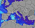 | 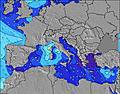 | 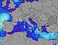 | 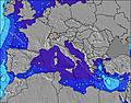 | 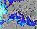 | 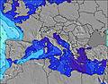 | 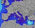 | |||||||||||||
Wave Height (m) Direction Period (s) | — | E 3 | ESE 2 | SE 3 | SSE 6 | SE 6 | SE 6 | SE 6 | SE 6 | SE 6 | SE 7 | SE 7 | SE 7 | SE 6 | SE 6 | SE 6 | SE 6 | SE 6 | SSE 5 | SE 5 |
Wave Graph | ||||||||||||||||||||
0 | 0 | 1 | 3 | 105 | 77 | 38 | 58 | 68 | 59 | 38 | 26 | 18 | 6 | 6 | 6 | 1 | 1 | 3 | 1 | |
Wind (km/h) | ||||||||||||||||||||
Wind State on-shore cross-onshore cross-shore cross-offshore off-shore glassy | cross | glassy | cross | cross-on | glassy | cross-off | on | cross-off | cross-off | cross-off | cross-off | cross-off | on | off | glassy | cross-on | glassy | glassy | on | off |
High Tide | 7:26PM0.22m | 6:54AM0.18m | 8:17PM0.24m | 7:51AM0.19m | 9:00PM0.25m | 8:36AM0.20m | 9:37PM0.27m | 9:15AM0.20m | 10:11PM0.28m | 9:51AM0.21m | 10:44PM0.29m | 10:25AM0.22m | 11:15PM0.30m | |||||||
Low Tide | 1:41AM0.12m | 1:17PM0.07m | 2:36AM0.11m | 2:06PM0.05m | 3:17AM0.10m | 2:47PM0.04m | 3:53AM0.09m | 3:24PM0.03m | 4:27AM0.08m | 3:59PM0.02m | 4:59AM0.08m | 4:31PM0.01m | ||||||||
— | — | 6:16 | — | — | 6:16 | — | — | 6:16 | — | — | 6:18 | — | — | 6:18 | — | — | 6:20 | — | — | |
8:42 | — | — | 8:40 | — | — | 8:39 | — | — | 8:39 | — | — | 8:38 | — | — | 8:37 | — | — | 8:37 | — | |
mm | — | — | — | — | — | — | — | — | — | — | — | — | — | — | — | — | — | — | — | — |
Temp °C | 33 | 27 | 29 | 30 | 29 | 31 | 32 | 31 | 30 | 32 | 28 | 29 | 29 | 28 | 31 | 33 | 28 | 30 | 31 | 28 |
Feels °C | 32 | 28 | 30 | 30 | 29 | 33 | 32 | 33 | 29 | 28 | 25 | 30 | 30 | 30 | 31 | 33 | 30 | 31 | 31 | 30 |
Swell 1 Height (m) Direction Period (s) | — | E 3 | NE 4 | NE 4 | SE 5 | SE 6 | SE 6 | SE 6 | SE 6 | SE 6 | SE 7 | SE 7 | SE 7 | SE 6 | SE 6 | SE 6 | SE 6 | SE 6 | — | SE 5 |
— | 1 | 1 | 1 | 49 | 77 | 38 | 58 | 68 | 59 | 38 | 26 | 18 | 6 | 6 | 6 | 1 | 1 | — | 1 | |
Swell 2 Height (m) Direction Period (s) | — | — | — | — | — | — | W 8 | WSW 7 | W 7 | W 7 | W 6 | W 7 | W 7 | SW 4 | — | — | — | — | — | — |
— | — | — | — | — | — | 1 | 5 | 4 | 1 | 1 | 1 | 1 | 1 | — | — | — | — | — | — | |
Swell 3 Height (m) Direction Period (s) | — | — | — | — | — | — | — | W 10 | W 8 | — | NE 4 | W 3 | WSW 7 | — | — | — | — | — | — | — |
— | — | — | — | — | — | — | 2 | 1 | — | 1 | 1 | 4 | — | — | — | — | — | — | — | |
Wind waves Height (m) Direction Period (s) | — | — | ESE 2 | SE 3 | SSE 6 | — | SSW 3 | — | NNW 3 | W 7 | NW 3 | NW 3 | — | NE 2 | ENE 3 | ESE 2 | — | — | SSE 5 | — |
— | — | 1 | 3 | 105 | — | 4 | — | 3 | 39 | 2 | 2 | — | 1 | 2 | 1 | — | — | 3 | — | |
Nearest Offshore or Glassy | ||||||||||||||||||||
Distance (km) | 1549 | 902 | 581 | 574 | 0 | 12 | 1471 | 12 | 12 | 424 | 22 | 13 | 1024 | 84 | 1023 | 1106 | 1034 | 1023 | 1106 | 1074 |
Best forecast wave conditions in Sardinia | ||||||||||||||||||||
Best forecast wave conditions in Italy | ||||||||||||||||||||
Header Global | ||||||||||||||||||||
- Map Icons:
 Break
Break Live Wave Height (m)
 Live Wind Speed (km/h)
 Surf Rating (10 Max)
 Ocean Swells (m)
- Wind Speed (km/h)


FREE! Surf-Forecast.com widget for your website
The surf report / weather widget below is available to embed on third party websites free of charge and provides a summary of our Porto Armando surf forecast. Simply grab the html code snippet that we provide and paste it into your own site. You can choose your preferred language and metric/imperial units for the surf forecast feed to suit users of your site. Click here to get the code.
Information about the Porto Armando Surf forecast
The above surf forecast table for Porto Armando provides essential information for determining whether the surfing conditions will be good over the next 16 days. A general guide to surfing at Porto Armando can be found by selecting the local surf guide option on the grey menu. Our Porto Armando surf forecast is unique since it includes wave energy (power) that defines the real feel of the surf rather than just the height or the period. If you surf the same spot (Porto Armando) regularly then make a mental note of the wave energy from the surf forecast table each time you go. Very soon you may start to choose your surf days based on the wave energy alone combined with our forecast of favourable offshore wind conditions. Our star ratings will help here and of course you will also find the usual wave height and period predictions on our surf forecasts as well as a full break down of the swell components under our advanced users option (to reveal that, click the little Einstein character under the tide times).
Further information to help with frequently asked questions about our surf forecast for Porto Armando may be found under the help tab on the top menu and also by moving your mouse over the question marks on the surf forecast table itself. Please always bear in mind that the forecast is for near-shore open water and local factors at each surf break influence the actual breaking wave height, such as the beach / reef profile, water depths offshore and shelter.
Porto Armando is 12 km (7 miles) from Quartu Sant'Elena. If you plan a holiday in Sardinia, look for hotels and other accommodation in Quartu Sant'Elena. Quartu Sant'Elena has rooms for a wide range of budgets as well as car hire and transport links.
 Nearest