

Surf Forecasts:

Newport-South Beach surf forecast from 3 Aug 2026:
- Best quality surf: Monday 10 Aug, 2AM (local time) - 6ft (1.8m), 8s period, NW swell with cross-offshore winds.
- Most powerful swell: Wednesday 5 Aug, 2AM (local time) - 7ft (2.1m), 8s period, NW swell with 481 kJ wave energy.
- Next surfable swell (1★+): Monday 3 Aug, 5AM (local time) - 4.5ft (1.4m), 8s period with WNW swell.
Best Forecast Surf Conditions for Newport-South Beach this week:
The surf forecast for Newport-South Beach over the next 16 days: The first swell (rated 1 star or higher) is forecast to arrive on Monday (Aug 03) at 5AM. The primary swell is predicted to be 1.4m and 8s period with a secondary swell of 0.4m and 13s. Another secondary swell of 1.0m and 6s is also forecast. The wind is predicted to be cross-offshore as the swell arrives.
The most powerful waves expected at Newport-South Beach in the next 16 days are 2.1m 8s and forecast to arrive on Wednesday (Aug 05) at 2AM. Winds are predicted to be cross-shore at the time the swell arrives.
| Wave Type | Time (PDT) & Date | Wave Height & Period |
|---|---|---|
| Next good surf (1 star+) | 5AM (Mon 3rd Aug) | 4.5ft (1.4m) 8s |
| Best Surf | 2AM (Mon 10th Aug) | 6ft (1.8m) 8s |
| Most Powerful | 2AM (Wed 5th Aug) | 7ft (2.1m) 8s |
Table - best surf conditions forecast for Newport-South Beach over the next 16 days.
The Lowdown
Alright folks, Rusty here. Let’s have a look at the stretch ahead for Newport-South Beach.
We’re looking at a pretty poor run of surf for the next couple of weeks. The first recommendation doesn’t even pop up until Monday the 16th, so there’s a solid gap of almost two weeks of nothing really worth paddling out for. The swell is mostly short-period windswell from the NW, coming in around 4ft to 8ft, and the winds are a problem. Most days we’ve got a cross or cross-onshore breeze, which is just mucking up the surface and making it choppy. The combined energy is moderate, climbing into the hundreds (275 to 1157), but it’s all poor quality. For a beach break like this, the short period (mostly 6-9 seconds) means the waves will be soft and sectiony. It’s not looking good for paddle surfing at all.
The week of August 3rd to the 9th is a write-off. Wind is consistently from the NNW, either cross or cross-onshore, and the swell is small and weak. It’s the kind of setup that might be more interesting for kite surfing than a paddle board.
The middle of the week starting August 10th sees a slight bump in size, with swell heights getting up to 7ft to 8ft, and the period stretches to 8-9 seconds. The combined energy is moderate to strong (532 to 1157), but the wind is still a problem – it’s almost always cross-onshore, keeping it choppy. The morning of August 10th has a gentler cross-shore wind, so it’s “marginal” rather than “poor,” but it’s still nothing to write home about.
The best chance we get is on Monday, August 16th. The morning shows a shift: wind turns onshore from the WSW at a light 6 mph, with some clouds. The swell is 5ft from the NW with an 8-second period, giving a moderate combined energy of 589. It’s still only a “2” out of 10 in the score, but it’s the best of a bad lot. The water temp is about average for the time of year, so no surprises there.
The very end of the run, August 17th and 18th, drops right off. Swell collapses to 2ft from the SW with a long 15-second period, but it’s cross-onshore and weak. Not worth getting wet for.
Bottom line: There’s nothing here that’s a standout. The whole 16-day window is pretty grim. The only day that might be worth a look is Monday the 16th, but keep your expectations on the floor. It’s one of those runs where the forecast can change, but as it stands, I’d be finding something else to do.
Rusty.
Short Range ForecastMostly dry. Warm (max 23°C on Tue morning, min 11°C on Sun night). Wind will be generally light. | Days 5-7 Weather SummaryMostly dry. Very mild (max 19°C on Thu afternoon, min 13°C on Wed night). Wind will be generally light. | ||||||||||||||||||
Monday 3 | Tuesday 4 | Wednesday 5 | Thursday 6 | Friday 7 | Saturday 8 | ||||||||||||||
Night | AM | PM | Night | AM | PM | Night | AM | PM | Night | AM | PM | Night | AM | PM | Night | AM | PM | Night | |
Swell Height Map |  |  |  |  | 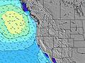 | 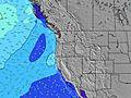 | 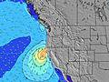 | ||||||||||||
Wave Height (m) Direction Period (s) | WNW 8 | NW 7 | NNW 7 | NNW 7 | NW 7 | NW 7 | NW 8 | NW 8 | NW 8 | NW 8 | NW 8 | NW 8 | NW 8 | NW 7 | NNW 7 | NNW 7 | NNW 6 | NNW 6 | NNW 7 |
Wave Graph | |||||||||||||||||||
300 | 218 | 392 | 428 | 255 | 352 | 481 | 344 | 371 | 333 | 257 | 247 | 210 | 151 | 180 | 186 | 137 | 213 | 278 | |
Wind (km/h) | |||||||||||||||||||
Wind State on-shore cross-onshore cross-shore cross-offshore off-shore glassy | cross-off | cross | cross | cross | cross | cross | cross | cross-on | cross-on | cross | cross-on | cross-on | cross | cross-on | cross-on | cross | cross | cross | cross |
High Tide | 3:29AM2.00m | 4:15PM2.30m | 4:26AM1.81m | 4:50PM2.37m | 5:36AM1.64m | 5:33PM2.43m | 7:03AM1.53m | 6:25PM2.47m | 8:41AM1.53m | 7:27PM2.52m | 10:05AM1.63m | 8:35PM2.58m | |||||||
Low Tide | 9:49PM0.61m | 9:47AM0.27m | 10:42PM0.50m | 10:21AM0.50m | 11:42PM0.39m | 11:01AM0.73m | 00:50AM0.27m | 11:51AM0.94m | 2:03AM0.12m | 12:57PM1.11m | 3:14AM-0.05m | 2:19PM1.18m | 4:16AM-0.23m | ||||||
— | 6:03 | — | — | 6:05 | — | — | 6:05 | — | — | 6:07 | — | — | 6:09 | — | — | 6:09 | — | — | |
8:39 | — | 8:38 | — | — | 8:37 | — | — | 8:36 | — | — | 8:35 | — | — | 8:34 | — | — | 8:31 | — | |
mm | — | — | — | — | — | — | — | — | — | — | — | — | — | — | — | — | — | — | — |
Temp °C | 15 | 18 | 20 | 16 | 23 | 22 | 17 | 21 | 20 | 16 | 18 | 19 | 15 | 18 | 18 | 15 | 18 | 18 | 15 |
Feels °C | 11 | 15 | 16 | 13 | 20 | 19 | 15 | 20 | 18 | 15 | 18 | 18 | 14 | 16 | 16 | 13 | 15 | 14 | 12 |
Swell 1 Height (m) Direction Period (s) | WNW 8 | SW 13 | SW 13 | WSW 16 | NW 7 | SW 16 | SW 15 | SW 15 | NW 8 | NW 8 | NW 8 | SW 14 | NW 8 | SW 13 | SW 13 | WNW 12 | SW 13 | SW 16 | WNW 11 |
300 | 27 | 27 | 51 | 255 | 63 | 57 | 54 | 371 | 333 | 257 | 64 | 210 | 60 | 58 | 46 | 56 | 94 | 64 | |
Swell 2 Height (m) Direction Period (s) | SW 13 | WSW 18 | WSW 17 | SW 13 | WSW 16 | SW 12 | SW 12 | SSW 12 | SW 14 | SW 14 | SW 14 | WSW 19 | SW 13 | SW 18 | SW 18 | SW 13 | SW 16 | WNW 11 | SW 17 |
62 | 30 | 28 | 26 | 50 | 6 | 6 | 14 | 53 | 51 | 93 | 37 | 61 | 50 | 81 | 57 | 68 | 45 | 104 | |
Swell 3 Height (m) Direction Period (s) | WSW 18 | — | — | — | SSW 12 | — | SW 12 | SW 12 | W 21 | SW 11 | SW 11 | W 16 | WNW 8 | WNW 15 | WNW 8 | SW 18 | NW 11 | SW 13 | SW 12 |
61 | — | — | — | 15 | — | 6 | 6 | 9 | 5 | 5 | 5 | 14 | 21 | 6 | 80 | 30 | 56 | 22 | |
Wind waves Height (m) Direction Period (s) | N 6 | NW 7 | NNW 7 | NNW 7 | — | NW 7 | NW 8 | NW 8 | — | — | — | NW 8 | — | NW 7 | NNW 7 | NNW 7 | NNW 6 | NNW 6 | NNW 7 |
72 | 218 | 392 | 428 | — | 352 | 481 | 344 | — | — | — | 247 | — | 151 | 180 | 186 | 137 | 213 | 278 | |
Nearest Offshore or Glassy | |||||||||||||||||||
Distance (km) | 15 | 251 | 422 | 15 | 251 | 299 | 15 | 185 | 256 | 15 | 256 | 504 | 15 | 315 | 510 | 15 | 396 | 415 | 299 |
Best forecast wave conditions in South Oregon | |||||||||||||||||||
Best forecast wave conditions in United States | |||||||||||||||||||
Header Global | |||||||||||||||||||
- Map Icons:
 Break
Break Live Wave Height (m)
 Live Wind Speed (km/h)
 Surf Rating (10 Max)
 Ocean Swells (m)
- Wind Speed (km/h)
Latest Updates


FREE! Surf-Forecast.com widget for your website
The surf report / weather widget below is available to embed on third party websites free of charge and provides a summary of our Newport-South Beach surf forecast. Simply grab the html code snippet that we provide and paste it into your own site. You can choose your preferred language and metric/imperial units for the surf forecast feed to suit users of your site. Click here to get the code.
Information about the Newport-South Beach Surf forecast
The above surf forecast table for Newport-South Beach provides essential information for determining whether the surfing conditions will be good over the next 16 days. A general guide to surfing at Newport-South Beach can be found by selecting the local surf guide option on the grey menu. Our Newport-South Beach surf forecast is unique since it includes wave energy (power) that defines the real feel of the surf rather than just the height or the period. If you surf the same spot (Newport-South Beach) regularly then make a mental note of the wave energy from the surf forecast table each time you go. Very soon you may start to choose your surf days based on the wave energy alone combined with our forecast of favourable offshore wind conditions. Our star ratings will help here and of course you will also find the usual wave height and period predictions on our surf forecasts as well as a full break down of the swell components under our advanced users option (to reveal that, click the little Einstein character under the tide times).
Further information to help with frequently asked questions about our surf forecast for Newport-South Beach may be found under the help tab on the top menu and also by moving your mouse over the question marks on the surf forecast table itself. Please always bear in mind that the forecast is for near-shore open water and local factors at each surf break influence the actual breaking wave height, such as the beach / reef profile, water depths offshore and shelter.
Newport-South Beach is 64 km (40 miles) from Corvallis. If you plan a vacation in South Oregon, look for hotels and other accommodation in Corvallis. Corvallis has rooms for a wide range of budgets as well as car hire and transport links.
 Nearest