

Surf Forecasts:

Miramar surf forecast from 2 Aug 2026:
- Best quality surf: Sunday 2 Aug, 7AM (local time) - 1.5ft (0.4m), 9s period, WNW swell with glassy winds.
- Most powerful swell: Monday 3 Aug, 7PM (local time) - 3.5ft (1.1m), 8s period, W swell with 141 kJ wave energy.
- Next surfable swell (1★+): Sunday 2 Aug, 7AM (local time) - 1.5ft (0.4m), 9s period with WNW swell.
Best Forecast Surf Conditions for Miramar this week:
The surf forecast for Miramar over the next 16 days: The first swell (rated 1 star or higher) is forecast to arrive on Sunday (Aug 02) at 7AM. The primary swell is predicted to be 0.4m and 9s period with a secondary swell of 0.6m and 5s. The wind is predicted to be glassy as the swell arrives.
The most powerful waves expected at Miramar in the next 16 days are 1.1m 8s and forecast to arrive on Monday (Aug 03) at 7PM. Winds are predicted to be cross-onshore at the time the swell arrives.
| Wave Type | Time (WEST) & Date | Wave Height & Period |
|---|---|---|
| Next good surf (1 star+) | 7AM (Sun 2nd Aug) | 1.5ft (0.4m) 9s |
| Best Surf | 7AM (Sun 2nd Aug) | 1.5ft (0.4m) 9s |
| Most Powerful | 7PM (Mon 3rd Aug) | 3.5ft (1.1m) 8s |
Table - best surf conditions forecast for Miramar over the next 16 days.
The Lowdown
Alright, let’s get straight into it. The outlook for Miramar is pretty flat and uninspiring for the most part, with only a few tiny windows that might get you wet. The first week is a grind, but there’s a couple of glassy mornings that are worth a look if you’re desperate.
Most of the time, we’ve got small, weak swell and off or cross-onshore winds messing things up. The combined wave energy stays low, often under 100 (53-99), which tells you there’s just not much power in the water. The few moments where the energy bumps into triple digits come with choppy, windy conditions that ruin any chance of a clean wave.
The standout here is Friday, August 7th morning. The wind goes glassy, dead calm, with a 3 ft NW swell. It’s small but clean, and the water temp is about average for this time of year. It’s a beginner-friendly wave at Miramar (beach and reef), and with light winds, you’ll at least get a few fun ones. That’s the best of the whole run.
Wednesday, August 12th and Thursday, August 13th also offer glassy starts with tiny 1 ft swells from the west, but the energy is pitiful (21 and 43). Only for the truly keen.
Friday, August 14th morning brings a 4 ft NW swell with a clean cross-offshore breeze from the NE, wave energy hits 109. It’s still small, but the cleanest conditions you’ll see for that size. Saturday, August 15th morning is similar – 4 ft NW swell, offshore ENE wind, clean (energy 112). Both of these are worth checking if you can sneak out early.
There’s a period with no real recommendations from about the 2nd to the 6th – a solid 5-day gap of poor surf. After that, the good windows are spaced out.
Overall, it’s not a classic stretch. The swell is small, short-period (4 to 10 seconds), mostly from the NW, which doesn’t line up perfectly with the optimum W direction for Miramar. Long-period groundswell isn’t on the cards. Keep your expectations low, and grab that glassy morning when it comes.
Stay stoked,
Rusty.
Short Range ForecastMostly dry. Warm (max 22°C on Mon morning, min 18°C on Sat night). Wind will be generally light. | Days 4-6 Weather SummaryMostly dry. Warm (max 23°C on Fri morning, min 17°C on Wed night). Wind will be generally light. | ||||||||||||||||||||
Sunday 2 | Monday 3 | Tuesday 4 | Wednesday 5 | Thursday 6 | Friday 7 | Saturday 8 | |||||||||||||||
AM | PM | Night | AM | PM | Night | AM | PM | Night | AM | PM | Night | AM | PM | Night | AM | PM | Night | AM | PM | Night | |
Swell Height Map |  |  |  | 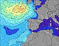 | 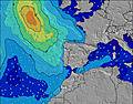 | 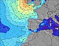 | 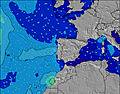 | ||||||||||||||
Wave Height (m) Direction Period (s) | WNW 9 | W 10 | W 9 | W 9 | WNW 9 | W 8 | W 9 | W 8 | W 8 | W 8 | NW 9 | NW 9 | NW 6 | NW 8 | NW 7 | NW 7 | NW 8 | NW 8 | NW 6 | WSW 4 | W 5 |
Wave Graph | |||||||||||||||||||||
26 | 46 | 61 | 78 | 123 | 110 | 95 | 86 | 66 | 41 | 51 | 38 | 40 | 107 | 109 | 91 | 69 | 41 | 18 | 13 | 16 | |
Wind (km/h) | |||||||||||||||||||||
Wind State on-shore cross-onshore cross-shore cross-offshore off-shore glassy | cross-on | cross-on | glassy | cross | cross-on | glassy | cross | on | glassy | cross-on | cross-on | cross-on | cross-on | cross-on | cross | glassy | cross-on | cross | cross | cross-on | glassy |
High Tide | 5:52AM2.68m | 6:06PM2.90m | 6:27AM2.64m | 6:42PM2.80m | 7:06AM2.58m | 7:23PM2.67m | 7:52AM2.49m | 8:14PM2.51m | 8:49AM2.39m | 9:19PM2.36m | 10:02AM2.33m | 10:43PM2.28m | 11:27AM2.37m | 00:11AM2.33m | |||||||
Low Tide | 11:50AM0.34m | 00:19AM0.30m | 12:27PM0.41m | 00:55AM0.38m | 1:07PM0.51m | 1:37AM0.50m | 1:56PM0.64m | 2:29AM0.64m | 2:58PM0.76m | 3:36AM0.78m | 4:20PM0.83m | 4:59AM0.83m | 5:51PM0.75m | ||||||||
6:30 | — | — | 6:31 | — | — | 6:31 | — | — | 6:33 | — | — | 6:33 | — | — | 6:35 | — | — | 6:35 | — | — | |
— | 8:50 | — | — | 8:49 | — | — | 8:47 | — | — | 8:46 | — | — | 8:45 | — | — | 8:44 | — | — | 8:43 | — | |
mm | — | — | — | — | — | — | — | — | — | — | — | — | — | — | — | — | — | — | — | — | — |
Temp °C | 21 | 21 | 20 | 22 | 22 | 21 | 22 | 22 | 21 | 22 | 22 | 19 | 21 | 21 | 20 | 23 | 22 | 20 | 21 | 21 | 19 |
Feels °C | 21 | 20 | 21 | 21 | 21 | 24 | 22 | 22 | 24 | 21 | 20 | 17 | 19 | 18 | 20 | 22 | 21 | 22 | 21 | 21 | 20 |
Swell 1 Height (m) Direction Period (s) | NW 5 | W 10 | W 9 | W 9 | WNW 9 | W 8 | W 9 | W 8 | W 8 | W 8 | W 7 | NW 5 | NW 6 | W 10 | NW 7 | NW 7 | NW 8 | NW 8 | NW 6 | NW 5 | W 5 |
16 | 46 | 61 | 78 | 123 | 110 | 95 | 86 | 66 | 41 | 37 | 34 | 40 | 48 | 109 | 91 | 69 | 41 | 18 | 7 | 16 | |
Swell 2 Height (m) Direction Period (s) | WNW 9 | NW 7 | NW 7 | NNW 7 | NW 7 | N 8 | N 8 | NNW 11 | NW 10 | WNW 10 | NW 9 | NW 9 | WNW 10 | W 12 | WNW 9 | WNW 9 | WNW 9 | W 9 | NNW 8 | W 9 | NW 10 |
26 | 2 | 8 | 5 | 2 | 1 | 1 | 12 | 16 | 19 | 51 | 38 | 32 | 3 | 29 | 17 | 17 | 14 | 7 | 6 | 14 | |
Swell 3 Height (m) Direction Period (s) | WSW 7 | — | NW 7 | — | — | — | W 12 | W 13 | W 13 | NW 8 | WNW 10 | W 7 | W 6 | — | W 13 | W 6 | W 5 | — | W 9 | NNW 8 | NNW 6 |
11 | — | 2 | — | — | — | 3 | 3 | 3 | 11 | 37 | 22 | 7 | — | 3 | 1 | 1 | — | 6 | 6 | 3 | |
Wind waves Height (m) Direction Period (s) | — | NW 5 | — | — | SW 3 | — | — | — | — | — | WNW 2 | — | — | NW 8 | — | — | — | — | — | WSW 4 | — |
— | 10 | — | — | 5 | — | — | — | — | — | 1 | — | — | 107 | — | — | — | — | — | 13 | — | |
Nearest Offshore or Glassy | |||||||||||||||||||||
Distance (km) | 66 | 175 | 0 | 5 | 175 | 0 | 5 | 170 | 0 | 33 | 200 | 27 | 71 | 310 | 27 | 0 | 310 | 16 | 35 | 310 | 33 |
Best forecast wave conditions in Douro and Minho | |||||||||||||||||||||
Best forecast wave conditions in Portugal | |||||||||||||||||||||
Header Global | |||||||||||||||||||||
- Map Icons:
 Break
Break Live Wave Height (m)
 Live Wind Speed (km/h)
 Surf Rating (10 Max)
 Ocean Swells (m)
- Wind Speed (km/h)
Latest Updates


FREE! Surf-Forecast.com widget for your website
The surf report / weather widget below is available to embed on third party websites free of charge and provides a summary of our Miramar surf forecast. Simply grab the html code snippet that we provide and paste it into your own site. You can choose your preferred language and metric/imperial units for the surf forecast feed to suit users of your site. Click here to get the code.
Information about the Miramar Surf forecast
The above surf forecast table for Miramar provides essential information for determining whether the surfing conditions will be good over the next 16 days. A general guide to surfing at Miramar can be found by selecting the local surf guide option on the grey menu. Our Miramar surf forecast is unique since it includes wave energy (power) that defines the real feel of the surf rather than just the height or the period. If you surf the same spot (Miramar) regularly then make a mental note of the wave energy from the surf forecast table each time you go. Very soon you may start to choose your surf days based on the wave energy alone combined with our forecast of favourable offshore wind conditions. Our star ratings will help here and of course you will also find the usual wave height and period predictions on our surf forecasts as well as a full break down of the swell components under our advanced users option (to reveal that, click the little Einstein character under the tide times).
Further information to help with frequently asked questions about our surf forecast for Miramar may be found under the help tab on the top menu and also by moving your mouse over the question marks on the surf forecast table itself. Please always bear in mind that the forecast is for near-shore open water and local factors at each surf break influence the actual breaking wave height, such as the beach / reef profile, water depths offshore and shelter.
Miramar is 5 km (3 miles) from the city of Canidelo. If you plan a holiday in Douro and Minho, look for hotels and other accommodation in Canidelo. Canidelo has rooms for a wide range of budgets as well as car hire and transport links.
 Nearest