
- Forecast
- Maps
- Live
- Weather State
- Spot Information
Surf Forecasts:


La Santa - El Quemao surfForecast / Lanzarote / Spain
Forecast update in hr min s Forecast update imminent
La Santa - El Quemao surf forecast is for near shore open water. Breaking waves will often be smaller at less exposed spots.
Today's La Santa - El Quemao sea temperature is
19.6° C
(Which is normal for this time of year)How big are the waves at La Santa - El Quemao today?
The current surf forecast for La Santa - El Quemao at 6AM is: 1.1m 12s primary swell from a Northwest direction and 0.6m 6s secondary swell from a North direction (forecast issued at 12:00am May 27). An open ocean swell of 0.4m 7s is not directed at the surf break. The wind direction is predicted to be cross-onshore.
| Time (WEST) & Date | Wave Height | Wave Period |
|---|---|---|
| Morning (27 May) | 3.5ft (1.1m) | 12s |
| Afternoon (27 May) | 3.5ft (1.0m) | 12s |
| Evening (27 May) | 3ft (0.9m) | 11s |
Table - waves today at La Santa - El Quemao. (Swell directed towards the surf break)
Updates in hr min s Forecast update imminent
Short Range ForecastMostly dry. Warm (max 21°C on Wed afternoon, min 17°C on Wed night). Mainly fresh winds. | ||||||||||||||||||||||||
Wednesday 27 | Thursday 28 | Friday 29 | ||||||||||||||||||||||
1 AM | 4 AM | 7 AM | 10 AM | 1 PM | 4 PM | 7 PM | 10 PM | 1 AM | 4 AM | 7 AM | 10 AM | 1 PM | 4 PM | 7 PM | 10 PM | 1 AM | 4 AM | 7 AM | 10 AM | 1 PM | 4 PM | 7 PM | 10 PM | |
Swell Height Map |  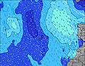 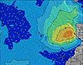 |  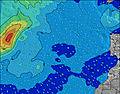 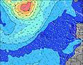 |  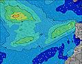 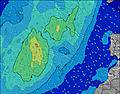 | |||||||||||||||||||||
NW 12 | NW 12 | NW 12 | NW 12 | NW 12 | NW 12 | NW 11 | NW 11 | NW 11 | NW 11 | NW 10 | NW 10 | NW 10 | NW 10 | NW 12 | NW 12 | NW 11 | NW 11 | NW 11 | NW 12 | NW 12 | NW 11 | NW 11 | NW 11 | |
324 | 324 | 319 | 314 | 309 | 259 | 198 | 165 | 162 | 110 | 100 | 96 | 77 | 59 | 71 | 114 | 103 | 97 | 84 | 120 | 228 | 242 | 229 | 220 | |
Wind (km/h) | ||||||||||||||||||||||||
cross-on | cross-on | cross-on | cross-on | cross-on | cross-on | cross-on | cross-on | cross-on | cross-on | cross-on | cross | cross-on | cross-on | cross-on | cross-on | cross | cross-on | cross-on | cross-on | cross-on | cross-on | cross-on | cross-on | |
High Tide | 11:32PM2.03m | 12:04PM2.02m | 00:18AM2.05m | 12:43PM2.10m | 00:58AM2.07m | 1:18PM2.16m | ||||||||||||||||||
Low Tide | 5:49AM0.48m | 6:09PM0.54m | 6:27AM0.44m | 6:49PM0.47m | 7:03AM0.41m | 7:26PM0.40m | ||||||||||||||||||
— | 6:56 | — | — | — | — | — | — | — | 6:56 | — | — | — | — | — | — | — | 6:56 | — | — | — | — | — | — | |
— | — | — | — | — | — | 8:45 | — | — | — | — | — | — | — | 8:45 | — | — | — | — | — | — | — | 8:46 | — | |
— | — | — | — | — | — | — | — | — | — | — | — | — | — | — | — | — | — | — | — | — | — | — | — | |
Temp °C | 20 | 19 | 19 | 20 | 20 | 21 | 20 | 18 | 17 | 17 | 17 | 18 | 19 | 18 | 18 | 17 | 17 | 17 | 17 | 17 | 18 | 19 | 18 | 17 |
19 | 19 | 18 | 19 | 19 | 20 | 18 | 16 | 15 | 15 | 14 | 15 | 17 | 14 | 15 | 14 | 14 | 14 | 14 | 13 | 15 | 16 | 14 | 14 | |
Swell 1 Height (m) Direction Period (s) | NW 12 | NW 12 | NW 12 | NW 12 | NW 12 | NW 12 | NW 11 | NW 11 | NW 11 | NW 11 | NW 10 | NW 10 | NW 10 | NW 10 | NW 9 | NW 12 | NW 11 | NW 11 | NW 11 | NW 12 | NW 12 | NW 11 | NW 11 | NW 11 |
324 | 324 | 319 | 314 | 309 | 259 | 198 | 165 | 162 | 110 | 100 | 96 | 77 | 59 | 41 | 114 | 103 | 97 | 75 | 120 | 228 | 242 | 229 | 220 | |
Swell 2 Height (m) Direction Period (s) | NE 7 | N 6 | NE 7 | NE 8 | NE 8 | NE 8 | NE 8 | NE 7 | SW 16 | SW 16 | NE 9 | NE 9 | NE 8 | NW 12 | NW 12 | SW 15 | NW 14 | NW 14 | NW 13 | NW 9 | SW 14 | SW 14 | NE 7 | SW 14 |
12 | 27 | 16 | 23 | 22 | 20 | 20 | 14 | 10 | 10 | 12 | 12 | 24 | 38 | 71 | 8 | 33 | 46 | 84 | 20 | 8 | 8 | 8 | 8 | |
Swell 3 Height (m) Direction Period (s) | WNW 10 | NE 7 | WNW 10 | SW 15 | SW 15 | SW 15 | SW 16 | SW 16 | NW 13 | NW 13 | NNW 13 | NNW 13 | NNW 13 | SW 15 | SW 15 | NW 15 | SW 15 | SW 15 | SW 14 | NW 11 | — | — | SW 14 | — |
10 | 17 | 10 | 9 | 9 | 9 | 10 | 10 | 7 | 7 | 17 | 17 | 16 | 8 | 8 | 8 | 9 | 8 | 8 | 30 | — | — | 8 | — | |
Wind waves Height (m) Direction Period (s) | N 6 | NNE 4 | N 6 | N 6 | N 6 | N 5 | N 4 | N 4 | N 5 | N 5 | N 5 | N 5 | N 5 | N 5 | N 5 | N 5 | NNE 5 | NNE 5 | N 6 | N 6 | N 6 | N 6 | N 6 | N 6 |
35 | 10 | 26 | 26 | 24 | 19 | 15 | 22 | 44 | 48 | 60 | 65 | 56 | 59 | 59 | 53 | 66 | 72 | 62 | 64 | 66 | 66 | 67 | 64 | |
Nearest Offshore or Glassy | ||||||||||||||||||||||||
Distance (km) | 52 | 1 | 25 | 32 | 142 | 25 | 25 | 243 | 248 | 32 | 32 | 32 | 32 | 243 | 32 | 32 | 32 | 32 | 32 | 32 | 32 | 243 | 243 | 243 |
Best forecast wave conditions in Lanzarote | ||||||||||||||||||||||||
Best forecast wave conditions in Spain (Africa) | ||||||||||||||||||||||||
Header Global | ||||||||||||||||||||||||
- Map Icons:
 Break
Break Live Wave Height (m)
 Live Wind Speed (km/h)
 Surf Rating (10 Max)
 Ocean Swells (m)
- Wind Speed (km/h)


FREE! Surf-Forecast.com widget for your website
The surf report / weather widget below is available to embed on third party websites free of charge and provides a summary of our La Santa - El Quemao surf forecast. Simply grab the html code snippet that we provide and paste it into your own site. You can choose your preferred language and metric/imperial units for the surf forecast feed to suit users of your site. Click here to get the code.
 Nearest