

Surf Forecasts:

Carrubo surf forecast from 1 Aug 2026:
- Most powerful swell: Saturday 8 Aug, 2PM (local time) - 1.5ft (0.4m), 5s period, W swell with 7 kJ wave energy.
Best Forecast Surf Conditions for Carrubo this week:
The most powerful waves expected at Carrubo in the next 16 days are 0.4m 5s and forecast to arrive on Saturday (Aug 08) at 2PM. Winds are predicted to be cross-onshore at the time the swell arrives. The largest open ocean swell (not directed at the beach) is 0.5m 4s period and expected on Friday (Aug 07) at 11PM.
| Wave Type | Time (CEST) & Date | Wave Height & Period |
|---|---|---|
| Next good surf (1 star+) | - | - |
| Best Surf | - | - |
| Most Powerful | 2PM (Sat 8th Aug) | 1.5ft (0.4m) 5s |
Table - best surf conditions forecast for Carrubo over the next 16 days.
The Lowdown
Alright, listen up. Rusty here, and I've got to be honest with you – the outlook for the next 16 days is a total flat spell. There's just nothing on the menu for us at Carrubo. The numbers are showing a big, fat zero for recommendations across the entire period. That's a long stretch of quiet water, a solid 16-day gap with no surf to speak of.
The water temperature is sitting at 85 °F, which is a whopping 5 °F warmer than average for this time of year. That's a very unusual anomaly, so the water will feel like a warm bath.
Now, let's get into the day-by-day, but it's a grim read. Saturday the 1st and Sunday the 2nd are completely flat with poor conditions. Monday the 3rd morning goes glassy with a northerly breeze, but there's still no swell. Tuesday the 4th morning is glassy again, but still flat. We finally see a tiny blip of energy on Wednesday the 5th morning – a 0.7 ft SSW swell with a 4-second period, pushing a combined energy of (2). That's tiny, weak, windswell, and not worth paddling out for. The morning is glassy, but the swell is just too small. The afternoon turns choppy. Thursday the 6th morning has a 0.3 ft SW swell, period 4 seconds, combined energy of (1), with a clean offshore north wind. Again, nothing to work with. Friday the 7th has a brief 1.0 ft westerly swell, period 4 seconds, energy of (3), but it's cross-shore and weak. The rest of the weekend, all of the next week, and right through to Sunday the 16th is a total write-off. There are a few more glassy mornings, like Monday the 10th and Saturday the 15th, but with zero swell, it doesn't mean a thing.
The break is rated as "fairly consistent," so this kind of prolonged flat spell is unusual for here. The setup is a beach break, so without any swell, there's nothing to ride. Stick to the swimming trunks, because the surfboard's gonna be collecting dust for a while.
Rusty.
Short Range ForecastMostly dry. Warm (max 30°C on Sat night, min 26°C on Sat night). Wind will be generally light. | Days 4-6 Weather SummaryMostly dry. Warm (max 30°C on Thu afternoon, min 26°C on Tue morning). Wind will be generally light. | ||||||||||||||||||||
Saturday 1 | Sunday 2 | Monday 3 | Tuesday 4 | Wednesday 5 | Thursday 6 | Friday 7 | |||||||||||||||
AM | PM | Night | AM | PM | Night | AM | PM | Night | AM | PM | Night | AM | PM | Night | AM | PM | Night | AM | PM | Night | |
Swell Height Map | 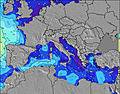 | 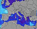 | 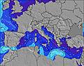 | 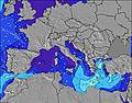 | 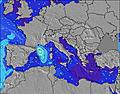 | 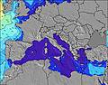 | 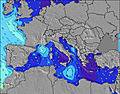 | ||||||||||||||
Wave Height (m) Direction Period (s) | WNW 5 | W 4 | W 4 | W 4 | W 5 | — | — | — | — | — | — | SW 4 | SSW 4 | SSW 4 | SSW 4 | SW 4 | — | WNW 3 | S 5 | W 4 | WNW 4 |
Wave Graph | |||||||||||||||||||||
0 | 0 | 0 | 0 | 0 | 0 | 0 | 0 | 0 | 0 | 0 | 2 | 1 | 2 | 2 | 1 | 0 | 0 | 1 | 3 | 0 | |
Wind (km/h) | |||||||||||||||||||||
Wind State on-shore cross-onshore cross-shore cross-offshore off-shore glassy | cross | on | glassy | cross-on | on | cross-off | glassy | cross-on | cross-off | glassy | cross-on | off | glassy | cross | off | off | cross | cross-off | cross | cross | cross-off |
High Tide | 11:23AM0.32m | 00:01AM0.37m | 12:00PM0.31m | 00:32AM0.37m | 12:40PM0.30m | 1:07AM0.35m | 1:27PM0.29m | 1:48AM0.33m | 2:25PM0.28m | 2:39AM0.31m | 3:40PM0.27m | 3:47AM0.30m | 5:11PM0.28m | ||||||||
Low Tide | 5:31PM0.03m | 6:14AM0.08m | 6:05PM0.04m | 6:50AM0.08m | 6:41PM0.06m | 7:30AM0.08m | 7:24PM0.09m | 8:18AM0.09m | 8:18PM0.11m | 9:18AM0.09m | 9:32PM0.14m | 10:33AM0.09m | 11:09PM0.15m | ||||||||
6:01 | — | — | 6:03 | — | — | 6:03 | — | — | 6:05 | — | — | 6:05 | — | — | 6:07 | — | — | 6:07 | — | — | |
— | 8:24 | — | — | 8:22 | — | — | 8:22 | — | — | 8:21 | — | — | 8:20 | — | — | 8:19 | — | — | 8:17 | — | |
mm | — | — | — | — | — | — | — | — | — | — | — | — | — | — | — | — | — | — | — | — | — |
Temp °C | 28 | 28 | 30 | 27 | 29 | 26 | 27 | 29 | 29 | 28 | 29 | 27 | 28 | 29 | 29 | 29 | 30 | 28 | 28 | 30 | 30 |
Feels °C | 31 | 31 | 30 | 30 | 30 | 26 | 28 | 30 | 31 | 29 | 29 | 28 | 29 | 29 | 31 | 28 | 28 | 27 | 31 | 29 | 30 |
Swell 1 Height (m) Direction Period (s) | WNW 5 | W 4 | W 4 | W 4 | W 5 | — | — | — | — | — | — | SW 4 | SSW 4 | — | SSW 4 | SW 4 | — | — | WNW 4 | — | W 4 |
8 | 3 | 1 | 1 | 4 | — | — | — | — | — | — | 2 | 1 | — | 2 | 1 | — | — | 2 | — | 2 | |
Swell 2 Height (m) Direction Period (s) | — | — | — | WNW 4 | — | — | — | — | — | — | — | — | S 5 | — | — | — | — | — | S 5 | — | — |
— | — | — | 2 | — | — | — | — | — | — | — | — | 1 | — | — | — | — | — | 1 | — | — | |
Swell 3 Height (m) Direction Period (s) | — | — | — | — | — | — | — | — | — | — | — | — | — | — | — | — | — | — | — | — | — |
— | — | — | — | — | — | — | — | — | — | — | — | — | — | — | — | — | — | — | — | — | |
Wind waves Height (m) Direction Period (s) | — | — | — | — | — | — | — | — | — | — | — | — | — | SSW 4 | — | — | — | WNW 3 | — | W 4 | WNW 4 |
— | — | — | — | — | — | — | — | — | — | — | — | — | 2 | — | — | — | 2 | — | 3 | 4 | |
Nearest Offshore or Glassy | |||||||||||||||||||||
Distance (km) | 1220 | 1429 | 1136 | 370 | 876 | 1272 | 1548 | 1580 | 1220 | 1220 | 1562 | 1313 | 1313 | 1224 | 834 | 1319 | 834 | 386 | 1298 | 365 | |
Best forecast wave conditions in West Coast of Italy | |||||||||||||||||||||
Best forecast wave conditions in Italy | |||||||||||||||||||||
Header Global | |||||||||||||||||||||
- Map Icons:
 Break
Break Live Wave Height (m)
 Live Wind Speed (km/h)
 Surf Rating (10 Max)
 Ocean Swells (m)
- Wind Speed (km/h)
Latest Updates


FREE! Surf-Forecast.com widget for your website
The surf report / weather widget below is available to embed on third party websites free of charge and provides a summary of our Carrubo surf forecast. Simply grab the html code snippet that we provide and paste it into your own site. You can choose your preferred language and metric/imperial units for the surf forecast feed to suit users of your site. Click here to get the code.
Information about the Carrubo Surf forecast
The above surf forecast table for Carrubo provides essential information for determining whether the surfing conditions will be good over the next 16 days. A general guide to surfing at Carrubo can be found by selecting the local surf guide option on the grey menu. Our Carrubo surf forecast is unique since it includes wave energy (power) that defines the real feel of the surf rather than just the height or the period. If you surf the same spot (Carrubo) regularly then make a mental note of the wave energy from the surf forecast table each time you go. Very soon you may start to choose your surf days based on the wave energy alone combined with our forecast of favourable offshore wind conditions. Our star ratings will help here and of course you will also find the usual wave height and period predictions on our surf forecasts as well as a full break down of the swell components under our advanced users option (to reveal that, click the little Einstein character under the tide times).
Further information to help with frequently asked questions about our surf forecast for Carrubo may be found under the help tab on the top menu and also by moving your mouse over the question marks on the surf forecast table itself. Please always bear in mind that the forecast is for near-shore open water and local factors at each surf break influence the actual breaking wave height, such as the beach / reef profile, water depths offshore and shelter.
Carrubo is 10 km (6 miles) from Sabaudia. If you plan a holiday in West Coast of Italy, look for hotels and other accommodation in Sabaudia. Sabaudia has rooms for a wide range of budgets as well as car hire and transport links.
 Nearest