

Surf Forecasts:

Zorba surf forecast from 3 Aug 2026:
- Best quality surf: Saturday 8 Aug, 6AM (local time) - 5.5ft (1.7m), 13s period, S swell with offshore winds.
- Most powerful swell: Saturday 8 Aug, 6AM (local time) - 5.5ft (1.7m), 13s period, S swell with 928 kJ wave energy.
- Next surfable swell (1★+): Monday 3 Aug, 6AM (local time) - 2ft (0.6m), 12s period with S swell.
Best Forecast Surf Conditions for Zorba this week:
The surf forecast for Zorba over the next 16 days: The first swell (rated 1 star or higher) is forecast to arrive on Monday (Aug 03) at 6AM. The primary swell is predicted to be 0.6m and 12s period with a secondary swell of 0.3m and 4s. The wind is predicted to be cross-offshore as the swell arrives.
The most powerful waves expected at Zorba in the next 16 days are 1.7m 13s and forecast to arrive on Saturday (Aug 08) at 6AM. Winds are predicted to be offshore at the time the swell arrives. The largest open ocean swell (not directed at the beach) is 1.8m 6s period and expected on Friday (Aug 07) at 6AM.
| Wave Type | Time (-03) & Date | Wave Height & Period |
|---|---|---|
| Next good surf (1 star+) | 6AM (Mon 3rd Aug) | 2ft (0.6m) 12s |
| Best Surf | 6AM (Sat 8th Aug) | 5.5ft (1.7m) 13s |
| Most Powerful | 6AM (Sat 8th Aug) | 5.5ft (1.7m) 13s |
Table - best surf conditions forecast for Zorba over the next 16 days.
The Lowdown
Alright, this is Rusty. Let's talk about what we've got cooking at Zorba over the next couple of weeks.
Honestly, the start of this outlook is a bit of a slow burn. The first few days are looking pretty ordinary, and I wouldn't bother paddling out until later in the first week. We've got a bit of a wait.
Monday the 3rd kicks off with a tiny 2ft south swell, period around 11 seconds. The wind is a messy cross-off in the morning, but it swings cross-on by the afternoon, making it choppy and uninviting. The combined energy is weak (130). This is a beginner spot, but the conditions are just not worth it right now. Tuesday the 4th and Wednesday the 5th are more of the same – small, wind-affected slop. The swell drops to 2ft on Wednesday, and the energy is really low (69). You're just fighting the wind for nothing.
Thursday the 6th is still tiny, with a 2ft easterly swell that has a short period of only 6 seconds. The wind is a clean cross-off in the morning, so the surface will be glassy, but there's just no push. The energy is a paltry 63.
Then things get interesting, but not in a good way. Friday the 7th sees a big jump in size to 8ft from the southwest, but that's coming with a brutal 28 mph cross-shore wind. The combined energy jumps to a moderate 529, but it's a total washing machine. The wave comment is "poor surf conditions," and that's an understatement. This is one for the kitesurfers, not for us.
Saturday the 8th is our first real standout. The swell drops to a clean 5ft from the south, but the period stretches out to a nice 12 seconds. The real winner is the offshore wind – a light northwesterly at 6 mph. The morning is looking glassy. The combined energy is strong at 759. This is the best on offer for the first week. Get out there early before the wind shifts.
Sunday the 9th gets messy again with a 7ft west-southwest swell and a fresh 19 mph cross-shore wind. The energy is moderate (553), but the conditions are lumpy. The rest of the following week, from Monday the 10th through to the weekend of the 16th, is a real mixed bag of moderate to strong swells, but almost always ruined by strong winds. There are a few clean moments, like the morning of Wednesday the 12th with a 6ft south swell and a light offshore wind (energy 938), but the wind shifts onshore in the afternoon. It's a tease.
Monday the 17th is a weird one. The morning is flat (0.3ft), but the afternoon sees a massive spike in combined energy to 1834 with a 8ft easterly swell. The period is only 10 seconds though, and the conditions are "marginal". That's a lot of power but not a lot of quality.
Finally, Tuesday the 18th looks like a promising finish. We get a 5ft easterly swell with a 11-second period, and a light offshore north-easterly wind. The combined energy is strong (536), and the forecast is for "very good surf conditions." This is a genuine contender for the best session of the whole outlook, but it's a long way out, so keep your fingers crossed.
Honestly, for the size range we're seeing, Zorba is a beginner-friendly spot, but when the swell pushes over 8ft, it's strictly for experts. The water temp is about average for this time of year.
So, the standout windows are Saturday morning the 8th and the looker on Tuesday the 18th. Get it while it's clean.
Rusty.
Short Range ForecastMostly dry. Very mild (max 16°C on Wed morning, min 12°C on Sun night). Wind will be generally light. | Days 5-7 Weather SummaryHeavy rain (total 45mm), heaviest during Thu night. Very mild (max 18°C on Thu afternoon, min 8°C on Fri night). Winds decreasing (near gales from the WSW on Thu night, light winds from the NW by Sat morning). | ||||||||||||||||||
Monday 3 | Tuesday 4 | Wednesday 5 | Thursday 6 | Friday 7 | Saturday 8 | ||||||||||||||
Night | AM | PM | Night | AM | PM | Night | AM | PM | Night | AM | PM | Night | AM | PM | Night | AM | PM | Night | |
Swell Height Map |  | 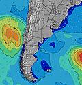 | 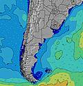 | 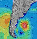 | 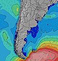 | 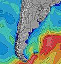 | 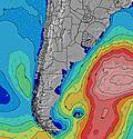 | ||||||||||||
Wave Height (m) Direction Period (s) | SSE 12 | S 11 | SSE 11 | SSE 11 | SSE 11 | SSE 10 | SSE 10 | SE 9 | SE 9 | SE 9 | SE 9 | ESE 6 | E 6 | SW 7 | SW 7 | S 12 | S 12 | S 12 | SSE 11 |
Wave Graph | |||||||||||||||||||
31 | 123 | 126 | 133 | 99 | 90 | 64 | 40 | 40 | 28 | 30 | 12 | 29 | 520 | 503 | 759 | 759 | 547 | 213 | |
Wind (km/h) | |||||||||||||||||||
Wind State on-shore cross-onshore cross-shore cross-offshore off-shore glassy | cross-off | cross-off | cross-on | cross-on | on | cross-on | cross | cross-off | cross-on | cross-on | cross-off | cross-off | cross-off | cross | cross-off | cross-off | off | cross-off | cross |
High Tide | 10:33PM0.28m | 3:41AM0.20m | 3:33PM0.16m | 11:20PM0.26m | 4:41AM0.21m | 00:10AM0.24m | 5:40AM0.21m | 12:08PM0.33m | 1:05AM0.22m | 6:44AM0.21m | 12:59PM0.36m | 2:04AM0.21m | 7:59AM0.20m | 1:56PM0.38m | 3:07AM0.19m | 3:00PM0.39m | |||
Low Tide | 2:00AM0.19m | 6:51AM0.14m | 3:03PM0.16m | 7:10PM0.08m | 7:30AM0.16m | 7:57PM0.06m | 3:11AM0.18m | 8:47PM0.04m | 3:57AM0.17m | 9:39PM0.03m | 4:51AM0.16m | 10:37PM0.02m | 5:55AM0.16m | 11:39PM0.02m | |||||
— | 7:31 | — | — | 7:31 | — | — | 7:30 | — | — | 7:28 | — | — | 7:28 | — | — | 7:28 | — | — | |
— | — | 5:59 | — | — | 6:00 | — | — | 6:00 | — | — | 6:00 | — | — | 6:01 | — | — | 6:02 | — | |
mm | — | — | — | — | — | — | — | — | — | — | — | — | 45 | — | — | — | — | — | — |
Temp °C | 14 | 13 | 14 | 14 | 14 | 14 | 15 | 16 | 14 | 14 | 17 | 18 | 16 | 10 | 10 | 10 | 10 | 12 | 11 |
Feels °C | 12 | 10 | 11 | 13 | 11 | 12 | 13 | 15 | 12 | 12 | 15 | 16 | 15 | 0 | 2 | 4 | 5 | 7 | 2 |
Swell 1 Height (m) Direction Period (s) | S 7 | S 11 | SSE 11 | SSE 11 | SSE 11 | SSE 10 | SE 6 | SE 9 | ESE 6 | SE 9 | ESE 6 | ESE 6 | E 6 | E 7 | E 8 | S 12 | S 12 | S 12 | SSE 11 |
14 | 123 | 126 | 133 | 99 | 90 | 33 | 40 | 21 | 28 | 12 | 12 | 29 | 9 | 1 | 759 | 759 | 547 | 213 | |
Swell 2 Height (m) Direction Period (s) | SSE 12 | E 4 | ENE 9 | ENE 8 | ENE 8 | ENE 7 | SSE 10 | S 10 | SE 9 | S 8 | SE 9 | SE 8 | NNE 3 | — | — | ENE 8 | — | NE 8 | E 8 |
31 | 1 | 8 | 14 | 6 | 5 | 64 | 2 | 40 | 1 | 19 | 10 | 1 | — | — | 6 | — | 2 | 1 | |
Swell 3 Height (m) Direction Period (s) | E 9 | E 9 | — | — | — | S 12 | S 11 | ENE 7 | — | S 11 | S 10 | S 9 | SE 8 | — | — | — | — | — | — |
6 | 6 | — | — | — | 3 | 3 | 4 | — | 2 | 2 | 2 | 2 | — | — | — | — | — | — | |
Wind waves Height (m) Direction Period (s) | E 4 | — | E 3 | ESE 3 | SSE 4 | SE 5 | — | ESE 6 | — | E 6 | E 6 | E 3 | NW 3 | SW 7 | SW 7 | WSW 5 | W 5 | W 4 | WSW 5 |
8 | — | 3 | 4 | 16 | 28 | — | 27 | — | 18 | 30 | 6 | 4 | 520 | 503 | 74 | 32 | 22 | 57 | |
Nearest Offshore or Glassy | |||||||||||||||||||
Distance (km) | 0 | 0 | 16 | 6 | 125 | 165 | 1 | 0 | 119 | 9 | 0 | 163 | 83 | 670 | 125 | 1 | 0 | 4 | 165 |
Best forecast wave conditions in Uruguay - South | |||||||||||||||||||
Best forecast wave conditions in Uruguay | |||||||||||||||||||
Header Global | |||||||||||||||||||
- Map Icons:
 Break
Break Live Wave Height (m)
 Live Wind Speed (km/h)
 Surf Rating (10 Max)
 Ocean Swells (m)
- Wind Speed (km/h)
Latest Updates


FREE! Surf-Forecast.com widget for your website
The surf report / weather widget below is available to embed on third party websites free of charge and provides a summary of our Zorba surf forecast. Simply grab the html code snippet that we provide and paste it into your own site. You can choose your preferred language and metric/imperial units for the surf forecast feed to suit users of your site. Click here to get the code.
Information about the Zorba Surf forecast
The above surf forecast table for Zorba provides essential information for determining whether the surfing conditions will be good over the next 16 days. A general guide to surfing at Zorba can be found by selecting the local surf guide option on the grey menu. Our Zorba surf forecast is unique since it includes wave energy (power) that defines the real feel of the surf rather than just the height or the period. If you surf the same spot (Zorba) regularly then make a mental note of the wave energy from the surf forecast table each time you go. Very soon you may start to choose your surf days based on the wave energy alone combined with our forecast of favourable offshore wind conditions. Our star ratings will help here and of course you will also find the usual wave height and period predictions on our surf forecasts as well as a full break down of the swell components under our advanced users option (to reveal that, click the little Einstein character under the tide times).
Further information to help with frequently asked questions about our surf forecast for Zorba may be found under the help tab on the top menu and also by moving your mouse over the question marks on the surf forecast table itself. Please always bear in mind that the forecast is for near-shore open water and local factors at each surf break influence the actual breaking wave height, such as the beach / reef profile, water depths offshore and shelter.
Are you planning a holiday in Uruguay - South? If you are looking for accommodation near Zorba, camping, hotels and holiday cottages in Uruguay - South, consider staying in Maldonado which is 6 km (4 miles) away. Other places in and around Uruguay - South where you can find information about places to rent, and car hire include San Carlos which is 17 km (11 miles) away, Minas, Rocha and La Paloma.
 Nearest