

Surf Forecasts:

El Morro de la Virgen surf forecast from 2 Aug 2026:
- Best quality surf: Monday 3 Aug, 9PM (local time) - 3ft (0.9m), 11s period, SSE swell with cross-offshore winds.
- Most powerful swell: Saturday 8 Aug, 12PM (local time) - 7.5ft (2.3m), 7s period, SW swell with 452 kJ wave energy.
- Next surfable swell (1★+): Monday 3 Aug, 9PM (local time) - 3ft (0.9m), 11s period with SSE swell.
Best Forecast Surf Conditions for El Morro de la Virgen this week:
The surf forecast for El Morro de la Virgen over the next 16 days: The first swell (rated 1 star or higher) is forecast to arrive on Monday (Aug 03) at 9PM. The primary swell is predicted to be 0.9m and 11s period with a secondary swell of 0.4m and 5s. The wind is predicted to be cross-offshore as the swell arrives.
The most powerful waves expected at El Morro de la Virgen in the next 16 days are 2.3m 7s and forecast to arrive on Saturday (Aug 08) at 12PM. Winds are predicted to be offshore at the time the swell arrives. The largest open ocean swell (not directed at the beach) is 0.8m 5s period and expected on Tuesday (Aug 04) at 6AM.
| Wave Type | Time (-03) & Date | Wave Height & Period |
|---|---|---|
| Next good surf (1 star+) | 9PM (Mon 3rd Aug) | 3ft (0.9m) 11s |
| Best Surf | 9PM (Mon 3rd Aug) | 3ft (0.9m) 11s |
| Most Powerful | 12PM (Sat 8th Aug) | 7.5ft (2.3m) 7s |
Table - best surf conditions forecast for El Morro de la Virgen over the next 16 days.
The Lowdown
Alright, Rusty here again, giving it to you straight.
The surf starts on Saturday, August 1st at El Morro de la Virgen. The water is sitting at 55°F, which is a touch warmer than average for this time of year, but don’t get too comfortable.
Saturday afternoon has a bit going for it. You’ve got a 3ft swell out of the east with a 10-second period and moderate wave energy (191). The wind is a light westerly, which means offshore and clean. The wave quality is "surfable" but not special. Crowds can show up here sometimes, so you won’t have solitude.
Then the wheels fall off. From Sunday, August 2nd through Friday morning, August 7th, it’s completely dead. Swell drops to 2ft at best, winds are mostly cross-onshore, and energy readings are pathetic (as low as 5). The only thing close to a session is Friday morning, August 7th – a strong offshore wind at 28 mph cleans up a tiny 1ft swell with 7-second period (18 energy). It’s clean but with no power to push you.
Things pick up on Saturday morning, August 8th. A 5ft southwest swell rolls in with a short 6-second period and moderate energy (179). Offshore wind at 13 mph keeps it clean, but the wave quality is still "very ordinary." Saturday afternoon gets bigger, with a 7ft SW swell (434 energy), but the wind is cross-offshore and fresh at 22 mph – clean but big.
The real standout is Tuesday, August 11th. This is the day to plan for. Morning session has a 5ft SSW groundswell with a solid 10-second period and strong energy (421). The wind is light offshore at 6 mph, giving you perfect clean lines. The wave comment says "expect good surf conditions." This is the best of the bunch. By afternoon, you’re looking at 6ft, 9-second period, and energy of 566 with a gentle cross-offshore breeze. Consistent, clean, and quality.
Wednesday, August 12th is strictly for experienced surfers. Morning has a 7ft south swell with 11-second period and a massive 2206 energy. The afternoon jumps to 8ft, a very long 14-second period, and an insane 4414 energy. The wind is cross-onshore, so expect chop on the faces. This is long-period groundswell that will be powerful and heavy, best at a reef or point. The break is sheltered from this SSE direction, so keep that in mind.
From August 13th to the 16th, the wind is straight onshore from the east, ruining any quality. Swell hangs around 4ft to 7ft, but it’s messy. However, Sunday morning the 16th turns glassy – zero wind, with a 6ft east swell and 7-second period (384 energy). The wave comment says "very ordinary," but with glassy conditions, there could be a few salvageable ones.
Summary: the first week is a bust. Tuesday, August 11th is your best bet for clean, quality surf. The 8th and 9th are okay, and the 12th is for the brave and the skilled.
Rusty
Short Range ForecastLight rain (total 7mm), mostly falling on Mon afternoon. Very mild (max 15°C on Sat afternoon, min 9°C on Sat night). Wind will be generally light. | Days 5-7 Weather SummaryHeavy rain (total 25mm), heaviest during Thu night. Very mild (max 18°C on Thu morning, min 12°C on Tue night). Winds increasing (light winds from the ESE on Tue night, strong winds from the WSW by Thu night). | |||||||||||||||||||
Sat 1 | Sunday 2 | Monday 3 | Tuesday 4 | Wednesday 5 | Thursday 6 | Friday 7 | ||||||||||||||
PM | Night | AM | PM | Night | AM | PM | Night | AM | PM | Night | AM | PM | Night | AM | PM | Night | AM | PM | Night | |
Swell Height Map |  | 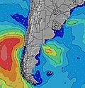 | 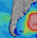 | 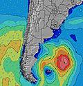 | 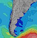 | 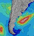 |  | |||||||||||||
Wave Height (m) Direction Period (s) | E 10 | E 10 | S 6 | E 9 | SSE 13 | SSE 11 | SSE 11 | SSE 11 | SSE 10 | SE 10 | SE 10 | SE 9 | SE 9 | SE 9 | SE 9 | SE 8 | SE 8 | SE 7 | ESE 7 | S 8 |
Wave Graph | ||||||||||||||||||||
190 | 92 | 22 | 60 | 32 | 167 | 170 | 176 | 130 | 100 | 74 | 67 | 53 | 41 | 46 | 31 | 16 | 14 | 5 | 5 | |
Wind (km/h) | ||||||||||||||||||||
Wind State on-shore cross-onshore cross-shore cross-offshore off-shore glassy | off | cross-off | cross-on | on | cross-on | cross-on | cross-on | cross-off | cross-off | cross | on | cross-on | cross-on | cross-on | cross | cross-on | cross | off | off | cross-off |
High Tide | 3:07PM0.24m | 9:15PM0.38m | 3:02AM0.21m | 3:46PM0.22m | 9:59PM0.37m | 3:53AM0.21m | 4:27PM0.20m | 10:46PM0.36m | 4:48AM0.21m | 5:07PM0.18m | 11:34PM0.34m | 5:46AM0.21m | 5:47PM0.15m | 00:26AM0.32m | 6:51AM0.21m | 12:40PM0.43m | 6:24PM0.13m | 8:06AM0.22m | 1:33PM0.46m | 2:17AM0.28m |
Low Tide | 5:37PM0.17m | 00:57AM0.17m | 6:09AM0.09m | 12:59PM0.14m | 6:21PM0.15m | 6:48AM0.11m | 1:54PM0.13m | 7:04PM0.13m | 7:26AM0.13m | 2:52PM0.13m | 7:48PM0.10m | 3:08AM0.14m | 3:58PM0.13m | 8:34PM0.08m | 3:57AM0.13m | 5:12PM0.13m | 9:24PM0.06m | 4:50AM0.12m | 10:19PM0.04m | |
— | — | 7:28 | — | — | 7:28 | — | — | 7:28 | — | — | 7:26 | — | — | 7:26 | — | — | 7:24 | — | — | |
5:54 | — | — | 5:55 | — | — | 5:55 | — | — | 5:57 | — | — | 5:58 | — | — | 5:59 | — | — | 5:59 | — | |
mm | 2 | — | — | — | — | — | 4 | 1 | — | — | — | — | — | — | — | — | 25 | — | — | — |
Temp °C | 15 | 12 | 11 | 12 | 11 | 14 | 15 | 15 | 12 | 13 | 13 | 15 | 15 | 15 | 18 | 18 | 18 | 12 | 11 | 10 |
Feels °C | 14 | 9 | 9 | 8 | 7 | 12 | 14 | 15 | 9 | 11 | 11 | 12 | 13 | 15 | 17 | 17 | 15 | 3 | 4 | 4 |
Swell 1 Height (m) Direction Period (s) | E 10 | E 10 | S 6 | S 6 | S 7 | SSE 11 | SSE 11 | SSE 11 | SSE 10 | SE 10 | SE 10 | SE 9 | SE 9 | SE 9 | SE 9 | SE 8 | SE 8 | SE 7 | ENE 4 | ENE 6 |
190 | 92 | 22 | 27 | 23 | 167 | 170 | 176 | 130 | 100 | 74 | 67 | 53 | 41 | 46 | 31 | 16 | 14 | 3 | 7 | |
Swell 2 Height (m) Direction Period (s) | S 9 | S 8 | E 10 | SSE 15 | ENE 9 | ENE 5 | E 5 | E 5 | E 6 | SE 6 | SE 6 | ESE 6 | ESE 6 | ESE 7 | ENE 7 | ENE 6 | ENE 6 | ENE 6 | ESE 7 | ESE 7 |
1 | 1 | 46 | 21 | 26 | 7 | 8 | 8 | 20 | 22 | 26 | 22 | 22 | 15 | 9 | 8 | 8 | 8 | 5 | 5 | |
Swell 3 Height (m) Direction Period (s) | — | — | S 11 | — | SSE 13 | ENE 9 | ENE 9 | ENE 8 | — | ENE 7 | ENE 7 | ENE 7 | ENE 7 | ENE 7 | S 10 | S 9 | S 9 | S 8 | ENE 7 | S 8 |
— | — | 2 | — | 32 | 7 | 7 | 7 | — | 18 | 18 | 9 | 9 | 9 | 8 | 7 | 6 | 1 | 4 | 5 | |
Wind waves Height (m) Direction Period (s) | — | S 4 | — | E 9 | ENE 4 | — | — | SSW 2 | S 5 | S 5 | ESE 6 | — | — | — | — | — | — | NNE 3 | NW 3 | SSW 4 |
— | 10 | — | 60 | 9 | — | — | 1 | 29 | 13 | 30 | — | — | — | — | — | — | 3 | 5 | 18 | |
Nearest Offshore or Glassy | ||||||||||||||||||||
Distance (km) | 0 | 6 | 4 | 42 | 4 | 3 | 3 | 41 | 301 | 91 | 3 | 2 | 4 | 4 | 2 | 491 | 661 | 586 | 586 | 344 |
Best forecast wave conditions in Uruguay - North | ||||||||||||||||||||
Best forecast wave conditions in Uruguay | ||||||||||||||||||||
Header Global | ||||||||||||||||||||
- Map Icons:
 Break
Break Live Wave Height (m)
 Live Wind Speed (km/h)
 Surf Rating (10 Max)
 Ocean Swells (m)
- Wind Speed (km/h)
Latest Updates


FREE! Surf-Forecast.com widget for your website
The surf report / weather widget below is available to embed on third party websites free of charge and provides a summary of our El Morro de la Virgen surf forecast. Simply grab the html code snippet that we provide and paste it into your own site. You can choose your preferred language and metric/imperial units for the surf forecast feed to suit users of your site. Click here to get the code.
Information about the El Morro de la Virgen Surf forecast
The above surf forecast table for El Morro de la Virgen provides essential information for determining whether the surfing conditions will be good over the next 16 days. A general guide to surfing at El Morro de la Virgen can be found by selecting the local surf guide option on the grey menu. Our El Morro de la Virgen surf forecast is unique since it includes wave energy (power) that defines the real feel of the surf rather than just the height or the period. If you surf the same spot (El Morro de la Virgen) regularly then make a mental note of the wave energy from the surf forecast table each time you go. Very soon you may start to choose your surf days based on the wave energy alone combined with our forecast of favourable offshore wind conditions. Our star ratings will help here and of course you will also find the usual wave height and period predictions on our surf forecasts as well as a full break down of the swell components under our advanced users option (to reveal that, click the little Einstein character under the tide times).
Further information to help with frequently asked questions about our surf forecast for El Morro de la Virgen may be found under the help tab on the top menu and also by moving your mouse over the question marks on the surf forecast table itself. Please always bear in mind that the forecast is for near-shore open water and local factors at each surf break influence the actual breaking wave height, such as the beach / reef profile, water depths offshore and shelter.
El Morro de la Virgen is 4 km (2 miles) from La Paloma. If you plan a holiday in Uruguay - North, look for hotels and other accommodation in La Paloma. La Paloma has rooms for a wide range of budgets as well as car hire and transport links.
 Nearest