

Surf Forecasts:

Tsujido Beach surf forecast from 2 Aug 2026:
- Most powerful swell: Thursday 6 Aug, 3PM (local time) - 10ft (3.0m), 16s period, S swell with 4,320 kJ wave energy.
Best Forecast Surf Conditions for Tsujido Beach this week:
The most powerful waves expected at Tsujido Beach in the next 16 days are 3.0m 16s and forecast to arrive on Thursday (Aug 06) at 3PM. Winds are predicted to be cross-shore at the time the swell arrives. The largest open ocean swell (not directed at the beach) is 1.0m 4s period and expected on Wednesday (Aug 05) at 6AM.
| Wave Type | Time (JST) & Date | Wave Height & Period |
|---|---|---|
| Next good surf (1 star+) | - | - |
| Best Surf | - | - |
| Most Powerful | 3PM (Thu 6th Aug) | 10ft (3.0m) 16s |
Table - best surf conditions forecast for Tsujido Beach over the next 16 days.
The Lowdown
Hey folks, Rusty here. We’re in for a bit of a wait at Tsujido Beach. The first week looks like a write-off for any proper waves, but there’s a chance of something decent if you’re patient and don’t mind a bit of size. The water’s sitting at a toasty 82°, which is a touch warmer than normal for the start of August.
The first few days are a real non-starter. Sunday and Monday mornings are tiny, with 1ft to 2ft of mostly SE swell, and the conditions are either a light cross-shore or clean but pathetic. You’d be better off with a cold drink than a surfboard. Things start to stir on Tuesday the 4th, but it’s still marginal with 5ft to 5ft of SE swell. The combined wave energy jumps up around 1059 to 1427 (moderate energy), but the mornings are clean while the afternoons get messy with a cross-chop. Wednesday the 5th sees a solid jump to 8ft to 10ft of SSE swell, and the energy is now strong at 3499 to 3908. This is getting chunky, and by Wednesday morning the 8ft is already pushing past beginner territory. The winds are cross-off in the morning but swing to a cross-shore chop in the arvo.
The real standout window is Thursday the 6th through Saturday the 8th of August. Thursday morning delivers a solid 10ft of S swell with a long period of 16 seconds, and the combined energy hits a massive 4010 (strong). The wind is a clean cross-off, which for a beach break like Tsujido is about as good as it gets. This is the best on offer—big, clean, groundswell lines. However, keep in mind that with the period over 15 seconds, it’s a very long period groundswell, at a beach break it could break a bit fast. It’s only for experienced surfers at this size. Friday the 7th keeps the swell at 8ft to 8ft of S swell, energy still strong, but the wind turns onshore in the afternoon, messing things up. Saturday the 8th drops to 6ft to 7ft of SSW swell, with energy still high around 1879, but the wind is onshore or light cross-onshore, so expect bumpy conditions.
After Saturday the 8th, it’s all downhill. From Sunday the 9th onward, the swell fades fast to under 3ft for most days, with poor surf conditions and no worthwhile ride. The combined energy drops to two-digit weak numbers by the 14th. The second week is a total bust—consistent but tiny and messy. The only slight blip is Monday the 17th, with 2ft of S swell, but it’s nothing to get wet for.
Overall, if you’re an expert and can handle the size, Thursday morning the 6th is your day. Clean, strong, big S swell. For everyone else, wait for the forecasts to change.
Rusty.
Short Range ForecastSome drizzle, heaviest during Sun night. Warm (max 32°C on Sun morning, min 22°C on Mon night). Winds increasing (light winds from the ENE on Sun morning, fresh winds from the ENE by Tue afternoon). | Days 4-6 Weather SummaryLight rain (total 8mm), mostly falling on Thu night. Warm (max 30°C on Fri morning, min 24°C on Wed morning). Wind will be generally light. | ||||||||||||||||||||
Sunday 2 | Monday 3 | Tuesday 4 | Wednesday 5 | Thursday 6 | Friday 7 | Saturday 8 | |||||||||||||||
AM | PM | Night | AM | PM | Night | AM | PM | Night | AM | PM | Night | AM | PM | Night | AM | PM | Night | AM | PM | Night | |
Swell Height Map |  |  |  | 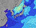 | 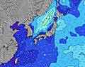 | 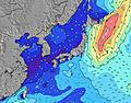 | 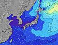 | ||||||||||||||
Wave Height (m) Direction Period (s) | ESE 16 | SE 15 | ESE 15 | SE 16 | SE 16 | SE 17 | SE 16 | SE 16 | SE 16 | SSE 16 | SSE 16 | SSE 16 | S 16 | S 16 | S 16 | S 15 | S 15 | S 15 | SSW 15 | SSW 15 | SSW 15 |
Wave Graph | |||||||||||||||||||||
99 | 104 | 148 | 258 | 448 | 648 | 1055 | 1415 | 2709 | 3499 | 3908 | 4058 | 4010 | 4320 | 3891 | 2925 | 2374 | 1963 | 1613 | 1623 | 1200 | |
Wind (km/h) | |||||||||||||||||||||
Wind State on-shore cross-onshore cross-shore cross-offshore off-shore glassy | cross | cross-on | cross | cross-off | cross-off | cross-off | cross-off | cross | cross-off | cross-off | cross | cross-off | cross-off | cross | cross | cross | on | cross-off | cross | cross-on | cross |
High Tide | 7:18PM1.46m | 7:00AM1.37m | 7:41PM1.46m | 7:48AM1.28m | 8:05PM1.45m | 8:47AM1.18m | 8:33PM1.43m | 10:11AM1.09m | 9:05PM1.40m | 12:46PM1.07m | 9:50PM1.36m | 3:25PM1.19m | 11:06PM1.33m | ||||||||
Low Tide | 12:47PM0.29m | 1:14AM0.61m | 1:15PM0.41m | 1:55AM0.55m | 1:44PM0.55m | 2:41AM0.50m | 2:14PM0.72m | 3:38AM0.47m | 2:45PM0.88m | 4:53AM0.43m | 3:24PM1.05m | 6:23AM0.36m | 5:47PM1.18m | ||||||||
4:50 | — | — | 4:50 | — | — | 4:52 | — | — | 4:52 | — | — | 4:54 | — | — | 4:54 | — | — | 4:54 | — | — | |
— | 6:45 | — | — | 6:44 | — | — | 6:43 | — | — | 6:43 | — | — | 6:42 | — | — | 6:40 | — | — | 6:39 | — | |
mm | — | — | 1 | — | — | — | — | — | — | — | — | — | — | 2 | 6 | — | — | — | 4 | 2 | 2 |
Temp °C | 32 | 31 | 26 | 26 | 27 | 24 | 27 | 27 | 24 | 26 | 28 | 26 | 29 | 29 | 26 | 30 | 30 | 27 | 28 | 29 | 26 |
Feels °C | 35 | 34 | 26 | 25 | 26 | 22 | 24 | 24 | 22 | 24 | 27 | 26 | 30 | 31 | 28 | 31 | 31 | 29 | 31 | 33 | 28 |
Swell 1 Height (m) Direction Period (s) | ESE 16 | SE 15 | ESE 15 | SE 16 | SE 16 | SE 17 | SE 16 | SE 16 | SE 16 | SSE 16 | SSE 16 | SSE 16 | S 16 | S 16 | S 16 | S 15 | S 15 | S 15 | SSW 15 | SSW 15 | SSW 15 |
99 | 104 | 148 | 258 | 448 | 648 | 1055 | 1415 | 2709 | 3499 | 3908 | 4058 | 4010 | 4320 | 3891 | 2925 | 2374 | 1963 | 1613 | 1623 | 1200 | |
Swell 2 Height (m) Direction Period (s) | SSW 5 | SE 9 | SSW 6 | SE 22 | S 8 | E 14 | E 14 | E 13 | — | — | — | — | — | ESE 10 | ESE 10 | — | — | SE 9 | SE 9 | SE 8 | ESE 12 |
5 | 3 | 3 | 18 | 1 | 4 | 4 | 3 | — | — | — | — | — | 86 | 103 | — | — | 412 | 290 | 256 | 13 | |
Swell 3 Height (m) Direction Period (s) | SE 9 | SE 7 | SE 9 | S 8 | — | — | — | — | — | — | — | — | — | — | — | — | — | — | — | — | — |
3 | 2 | 3 | 1 | — | — | — | — | — | — | — | — | — | — | — | — | — | — | — | — | — | |
Wind waves Height (m) Direction Period (s) | — | S 6 | ENE 2 | NE 3 | NE 3 | NE 3 | NNE 3 | NE 3 | — | NNE 4 | — | — | — | — | — | — | — | — | — | — | — |
— | 7 | 2 | 5 | 5 | 7 | 10 | 9 | — | 34 | — | — | — | — | — | — | — | — | — | — | — | |
Nearest Offshore or Glassy | |||||||||||||||||||||
Distance (km) | 4 | 47 | 48 | 137 | 542 | 481 | 137 | 481 | 481 | 478 | 2205 | 4 | 4 | 4 | 2 | 2 | 47 | 4 | 4 | 3 | 2 |
Best forecast wave conditions in Kanagawa | |||||||||||||||||||||
Best forecast wave conditions in Japan | |||||||||||||||||||||
Header Global | |||||||||||||||||||||
- Map Icons:
 Break
Break Live Wave Height (m)
 Live Wind Speed (km/h)
 Surf Rating (10 Max)
 Ocean Swells (m)
- Wind Speed (km/h)
Latest Updates


FREE! Surf-Forecast.com widget for your website
The surf report / weather widget below is available to embed on third party websites free of charge and provides a summary of our Tsujido Beach surf forecast. Simply grab the html code snippet that we provide and paste it into your own site. You can choose your preferred language and metric/imperial units for the surf forecast feed to suit users of your site. Click here to get the code.
Information about the Tsujido Beach Surf forecast
The above surf forecast table for Tsujido Beach provides essential information for determining whether the surfing conditions will be good over the next 16 days. A general guide to surfing at Tsujido Beach can be found by selecting the local surf guide option on the grey menu. Our Tsujido Beach surf forecast is unique since it includes wave energy (power) that defines the real feel of the surf rather than just the height or the period. If you surf the same spot (Tsujido Beach) regularly then make a mental note of the wave energy from the surf forecast table each time you go. Very soon you may start to choose your surf days based on the wave energy alone combined with our forecast of favourable offshore wind conditions. Our star ratings will help here and of course you will also find the usual wave height and period predictions on our surf forecasts as well as a full break down of the swell components under our advanced users option (to reveal that, click the little Einstein character under the tide times).
Further information to help with frequently asked questions about our surf forecast for Tsujido Beach may be found under the help tab on the top menu and also by moving your mouse over the question marks on the surf forecast table itself. Please always bear in mind that the forecast is for near-shore open water and local factors at each surf break influence the actual breaking wave height, such as the beach / reef profile, water depths offshore and shelter.
Tsujido Beach is 3 km (2 miles) from the city of Chigasaki. If you plan a holiday in Kanagawa, look for hotels and other accommodation in Chigasaki. Chigasaki has rooms for a wide range of budgets as well as car hire and transport links.
 Nearest