

Surf Forecasts:

Onjuku surf forecast from 3 Aug 2026:
- Best quality surf: Tuesday 4 Aug, 9AM (local time) - 11ft (3.5m), 16s period, SE swell with cross-offshore winds.
- Most powerful swell: Wednesday 5 Aug, 3AM (local time) - 13ft (4.0m), 16s period, SE swell with 8,338 kJ wave energy.
- Next surfable swell (1★+): Tuesday 4 Aug, 9AM (local time) - 11ft (3.5m), 16s period with SE swell.
Best Forecast Surf Conditions for Onjuku this week:
The surf forecast for Onjuku over the next 16 days: The first swell (rated 1 star or higher) is forecast to arrive on Tuesday (Aug 04) at 9AM. The primary swell is predicted to be 3.5m and 16s period with a secondary swell of 0.4m and 14s. Another secondary swell of 2.0m and 7s is also forecast. The wind is predicted to be cross-offshore as the swell arrives.
The most powerful waves expected at Onjuku in the next 16 days are 4.0m 16s and forecast to arrive on Wednesday (Aug 05) at 3AM. Winds are predicted to be offshore at the time the swell arrives. The largest open ocean swell (not directed at the beach) is 2.2m 7s period and expected on Monday (Aug 10) at 9AM.
| Wave Type | Time (JST) & Date | Wave Height & Period |
|---|---|---|
| Next good surf (1 star+) | 9AM (Tue 4th Aug) | 11ft (3.5m) 16s |
| Best Surf | 9AM (Tue 4th Aug) | 11ft (3.5m) 16s |
| Most Powerful | 3AM (Wed 5th Aug) | 13ft (4.0m) 16s |
Table - best surf conditions forecast for Onjuku over the next 16 days.
The Lowdown
G’day, Rusty here. Let’s have a look at what’s on offer over the next couple of weeks.
First up, we’ve got a bit of a wait on our hands. The surf kicks off on Monday, 3 August, but honestly, it’s not worth paddling out for. Onjuku is a bit inconsistent at the best of times, and right now the combination of a 30 km/h cross-offshore breeze and a 6ft swell from the SE with a long 16-second period is making for a clean but messy setup. The water’s sitting at 82°, which is a touch warmer than normal for this time of year. The wave energy is moderate (2032), but the swell quality is just not there for a proper session.
Moving into Tuesday, 4 August, the swell starts to build. By Tuesday morning we’re looking at 12ft from the SE, still with a 16-second period and a steady 35 km/h cross-offshore wind. The wave energy jumps up to a strong 6573, but the problem is that 12ft is too big for most surfers – this is expert-only territory, and even then the wind is holding it together but it’s a brute. Wednesday, 5 August, pushes it even further, with 13ft waves and very strong energy (8089). Again, the wind is solid cross-offshore, but this is a full-on big-wave day, not for the faint-hearted.
Thursday, 6 August, we see a slight drop to 12ft, with a bit less wind (15 km/h) and a shift to an onshore breeze in the afternoon, plus a risk of thunderstorms. The wave energy is still strong (5057), but the afternoon turns into a cross-shore chop, so that morning window might be the only chance for the brave. By Friday, 7 August, the swell is down to 8ft, but the wind is swinging cross-shore and the risk of t-storms persists – nothing to get excited about.
Saturday, 8 August, things ease off to 6ft, but the wind is cross-shore and the energy dips to 1875. The surf is clean but marginal, and the swell period is down to 14 seconds. Sunday, 9 August, is even smaller at 6ft, with a fresh 30 km/h cross-offshore but the wave energy is still moderate (1814). It’s clean, but not really pushing.
Now, Monday, 10 August, brings another spike – 12ft from the E with a 13-second period and a strong 40 km/h offshore wind. The energy is very strong (4243), and the wind is offshore, making it clean but a real battle to paddle into. This is for experts only, and even then the wind is howling. Tuesday, 11 August, sees a drop to 8ft, with the wind still offshore, but the wave energy is moderate (2432) – still a bit tricky.
Wednesday, 12 August, we’ve got a light onshore breeze from the SSW, and the swell is 8ft from the E with moderate energy (2368). The wind is turning onshore, so it’s not looking great. Thursday, 13 August, is a bit better – 6ft with a cross-offshore breeze and moderate energy (1063), but it’s still not a standout.
Friday, 14 August, is a write-off – 5ft, onshore wind, and low energy (650). Poor conditions all round.
Then, Saturday, 15 August, the swell picks up again to 8ft from the ESE, with a 11-second period and moderate energy (1245). The wind is cross-offshore, so it’s clean but not a classic. Sunday, 16 August, we get a big jump to 13ft from the ESE, with very strong energy (8887) – again, too big for most, but the wind is moderate and cross-offshore, so it’s clean and powerful. Monday, 17 August, is the biggest of the lot – 16ft from the ESE, with a massive energy of 12497. This is a solid groundswell, but it’s only for the absolute top crew. The wind is moderate and cross-offshore, so it’s clean, but you’ll need a big board and a bigger pair.
Finally, Tuesday, 18 August, we drop back to 8ft with moderate energy (1514). The wind is cross-offshore, so it’s clean, but nothing special.
The standout? Honestly, there’s not a single day that screams “paddle out now” for the average surfer. The biggest swells are too big for most, and the smaller days are marginal. If you’re an expert, the mornings of Tuesday, 4 August, or Monday, 10 August, offer the best combination of clean conditions and serious power. For everyone else, maybe wait for a better window.
Rusty.
Short Range ForecastLight rain (total 3mm), mostly falling on Wed night. Warm (max 26°C on Wed afternoon, min 22°C on Mon night). Mainly fresh winds. | Days 4-6 Weather SummaryModerate rain (total 14mm), heaviest on Fri morning. Warm (max 28°C on Thu morning, min 24°C on Sat night). Wind will be generally light. | ||||||||||||||||||||
Monday 3 | Tuesday 4 | Wednesday 5 | Thursday 6 | Friday 7 | Saturday 8 | Sunday 9 | |||||||||||||||
AM | PM | Night | AM | PM | Night | AM | PM | Night | AM | PM | Night | AM | PM | Night | AM | PM | Night | AM | PM | Night | |
Swell Height Map |  |  |  | 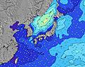 | 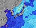 | 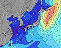 | 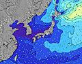 | ||||||||||||||
Wave Height (m) Direction Period (s) | SE 16 | SE 17 | SE 16 | SE 16 | SE 16 | SE 16 | SE 16 | SE 16 | SSE 15 | SSE 15 | S 15 | SSE 15 | S 15 | S 15 | S 14 | SSW 14 | SSW 14 | SSW 15 | SSW 15 | SSW 16 | SSW 15 |
Wave Graph | |||||||||||||||||||||
1901 | 2970 | 3569 | 6018 | 6568 | 6731 | 8064 | 7832 | 5601 | 4986 | 4752 | 5059 | 3107 | 2153 | 1640 | 1325 | 1189 | 1137 | 894 | 938 | 539 | |
Wind (km/h) | |||||||||||||||||||||
Wind State on-shore cross-onshore cross-shore cross-offshore off-shore glassy | cross-off | cross-off | cross-off | cross-off | cross-off | cross-off | cross-off | cross-off | cross-off | cross-off | cross | cross | cross | cross | cross-on | cross | cross | cross-off | cross-off | cross-off | off |
High Tide | 7:27PM1.38m | 7:32AM1.21m | 7:51PM1.38m | 8:31AM1.11m | 8:17PM1.37m | 9:58AM1.02m | 8:49PM1.35m | 12:56PM1.00m | 9:31PM1.33m | 10:43PM1.31m | 4:10PM1.23m | 00:23AM1.32m | |||||||||
Low Tide | 1:00PM0.40m | 1:40AM0.55m | 1:27PM0.54m | 2:28AM0.50m | 1:55PM0.69m | 3:27AM0.45m | 2:20PM0.85m | 4:43AM0.41m | 2:29PM1.00m | 6:13AM0.33m | 7:36AM0.23m | 7:43PM1.16m | |||||||||
4:48 | — | — | 4:48 | — | — | 4:48 | — | — | 4:50 | — | — | 4:50 | — | — | 4:52 | — | — | 4:52 | — | — | |
— | 6:39 | — | — | 6:38 | — | — | 6:38 | — | — | 6:37 | — | — | 6:37 | — | — | 6:36 | — | — | 6:35 | — | |
mm | — | — | — | — | — | — | — | — | 3 | 2 | 1 | 3 | 4 | 2 | 2 | — | — | — | — | — | — |
Temp °C | 24 | 25 | 23 | 24 | 24 | 23 | 25 | 26 | 25 | 28 | 28 | 26 | 27 | 27 | 26 | 27 | 27 | 24 | 25 | 25 | 23 |
Feels °C | 23 | 23 | 21 | 21 | 21 | 21 | 24 | 26 | 27 | 30 | 30 | 28 | 29 | 28 | 29 | 29 | 28 | 25 | 22 | 21 | 19 |
Swell 1 Height (m) Direction Period (s) | SE 16 | SE 17 | SE 16 | SE 16 | SE 16 | SE 16 | SE 16 | SE 16 | SSE 15 | SSE 15 | S 15 | SSE 15 | S 15 | S 15 | S 14 | SSW 14 | SE 9 | ESE 12 | ESE 13 | ESE 13 | E 7 |
1901 | 2970 | 3569 | 6018 | 6568 | 6731 | 8064 | 7832 | 5601 | 4986 | 4752 | 5059 | 3107 | 2153 | 1640 | 1325 | 461 | 893 | 894 | 711 | 261 | |
Swell 2 Height (m) Direction Period (s) | E 14 | E 14 | E 14 | E 14 | E 13 | E 13 | E 18 | — | E 17 | E 16 | ESE 9 | E 15 | ESE 9 | SE 9 | ESE 9 | SE 9 | SSW 14 | SSW 15 | SSW 15 | SSW 16 | ESE 13 |
34 | 61 | 59 | 57 | 54 | 87 | 25 | — | 22 | 20 | 329 | 41 | 441 | 491 | 440 | 514 | 1189 | 1137 | 886 | 938 | 461 | |
Swell 3 Height (m) Direction Period (s) | E 14 | — | — | E 13 | — | — | — | — | E 12 | ENE 16 | E 16 | ENE 15 | E 15 | E 15 | E 14 | E 14 | SE 12 | ENE 14 | ENE 13 | — | SSW 15 |
97 | — | — | 92 | — | — | — | — | 66 | 51 | 20 | 45 | 39 | 39 | 37 | 36 | 157 | 38 | 34 | — | 539 | |
Wind waves Height (m) Direction Period (s) | NE 6 | ENE 7 | ENE 7 | ENE 7 | ENE 7 | ENE 7 | — | E 8 | — | — | — | — | — | ESE 9 | — | — | — | — | — | ENE 4 | NNE 5 |
126 | 175 | 223 | 406 | 455 | 301 | — | 454 | — | — | — | — | — | 601 | — | — | — | — | — | 42 | 56 | |
Nearest Offshore or Glassy | |||||||||||||||||||||
Distance (km) | 536 | 51 | 206 | 206 | 51 | 557 | 554 | 51 | 51 | 51 | 2269 | 75 | 2342 | 117 | 17 | 51 | 117 | 40 | 2644 | 2269 | 631 |
Best forecast wave conditions in Chiba | |||||||||||||||||||||
Best forecast wave conditions in Japan | |||||||||||||||||||||
Header Global | |||||||||||||||||||||
- Map Icons:
 Break
Break Live Wave Height (m)
 Live Wind Speed (km/h)
 Surf Rating (10 Max)
 Ocean Swells (m)
- Wind Speed (km/h)
Latest Updates


FREE! Surf-Forecast.com widget for your website
The surf report / weather widget below is available to embed on third party websites free of charge and provides a summary of our Onjuku surf forecast. Simply grab the html code snippet that we provide and paste it into your own site. You can choose your preferred language and metric/imperial units for the surf forecast feed to suit users of your site. Click here to get the code.
Information about the Onjuku Surf forecast
The above surf forecast table for Onjuku provides essential information for determining whether the surfing conditions will be good over the next 16 days. A general guide to surfing at Onjuku can be found by selecting the local surf guide option on the grey menu. Our Onjuku surf forecast is unique since it includes wave energy (power) that defines the real feel of the surf rather than just the height or the period. If you surf the same spot (Onjuku) regularly then make a mental note of the wave energy from the surf forecast table each time you go. Very soon you may start to choose your surf days based on the wave energy alone combined with our forecast of favourable offshore wind conditions. Our star ratings will help here and of course you will also find the usual wave height and period predictions on our surf forecasts as well as a full break down of the swell components under our advanced users option (to reveal that, click the little Einstein character under the tide times).
Further information to help with frequently asked questions about our surf forecast for Onjuku may be found under the help tab on the top menu and also by moving your mouse over the question marks on the surf forecast table itself. Please always bear in mind that the forecast is for near-shore open water and local factors at each surf break influence the actual breaking wave height, such as the beach / reef profile, water depths offshore and shelter.
Onjuku is 3 km (2 miles) from Ohara. If you plan a holiday in Chiba, look for hotels and other accommodation in Ohara. Ohara has rooms for a wide range of budgets as well as car hire and transport links.
 Nearest