

Surf Forecasts:

Tres Palmas (Rincon) surf forecast from 3 Aug 2026:
- Most powerful swell: Monday 3 Aug, 2PM (local time) - 2ft (0.6m), 6s period, NNE swell with 26 kJ wave energy.
Best Forecast Surf Conditions for Tres Palmas (Rincon) this week:
The most powerful waves expected at Tres Palmas (Rincon) in the next 16 days are 0.6m 6s and forecast to arrive on Monday (Aug 03) at 2PM. Winds are predicted to be cross-shore at the time the swell arrives. The largest open ocean swell (not directed at the beach) is 1.5m 5s period and expected on Sunday (Aug 09) at 5PM.
| Wave Type | Time (AST) & Date | Wave Height & Period |
|---|---|---|
| Next good surf (1 star+) | - | - |
| Best Surf | - | - |
| Most Powerful | 2PM (Mon 3rd Aug) | 2ft (0.6m) 6s |
Table - best surf conditions forecast for Tres Palmas (Rincon) over the next 16 days.
The Lowdown
Alright, Rusty here again. Let’s switch to feet and degrees.
Looking at the Rincon zone, it’s a flat spell that’s going to test your patience. There’s a big gap of several days with nothing rideable from the start. Monday and Tuesday are dead zeros – poor surf, no waves. The first little flicker shows up on the morning of Wednesday the 5th, with a tiny 0.3ft north swell, 9-second period, and combined energy of just 2 – that’s weak, barely a bump. The wind is glassy calm, so the surface is nice, but there’s nothing to push you.
The pattern doesn’t change. Friday the 7th morning gives us a 1.0ft NNE swell, still 9 seconds, with energy at 16 – still weak. The wind is glassy, so it’s clean, but we’re talking about waves that are barely ankle-high. The afternoon is the same size, same direction, same weak energy.
The best of a bad bunch is Friday the 7th morning. That 1.0ft, 9-second NNE swell under glassy wind is the most you’ll see. Combined energy is 16 (weak). The swell direction is off from the optimum WNW for Tres Palmas, so it’s not wrapping in well. The water temp is 84°, with a 1° anomaly, so it’s about average for the time of year – warm. The reef is inconsistent, and it’s advanced-only, so unless you’re a local who knows the nooks, you’ll be sitting on your board.
Nothing in this 16-day window is a standout. The swell never gets above 1.0ft, the period is short, and the energy is always low. For a heavy reef like Tres Palmas, you need size and the right direction, and we’ve got neither. This is a dry spell, and it’s normal for the area. Keep the wax in the shade.
Rusty.
Short Range ForecastModerate rain (total 10mm), heaviest on Wed afternoon. Warm (max 29°C on Mon afternoon, min 26°C on Mon night). Wind will be generally light. | Days 4-6 Weather SummaryLight rain (total 4mm), mostly falling on Thu afternoon. Warm (max 29°C on Thu afternoon, min 26°C on Thu morning). Wind will be generally light. | ||||||||||||||||||||
Monday 3 | Tuesday 4 | Wednesday 5 | Thursday 6 | Friday 7 | Saturday 8 | Sunday 9 | |||||||||||||||
AM | PM | Night | AM | PM | Night | AM | PM | Night | AM | PM | Night | AM | PM | Night | AM | PM | Night | AM | PM | Night | |
Swell Height Map |  |  |  | 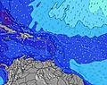 | 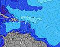 | 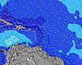 | 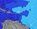 | ||||||||||||||
Wave Height (m) Direction Period (s) | NE 6 | NNE 4 | NE 6 | NE 5 | NE 4 | NNE 4 | N 9 | N 11 | NE 6 | NE 7 | NE 6 | NNE 9 | NNE 9 | NNE 9 | NE 7 | NE 9 | NNE 6 | NNE 9 | N 12 | NE 5 | NE 6 |
Wave Graph | |||||||||||||||||||||
0 | 3 | 0 | 0 | 0 | 1 | 2 | 3 | 0 | 0 | 0 | 8 | 16 | 9 | 0 | 0 | 3 | 7 | 3 | 0 | 0 | |
Wind (km/h) | |||||||||||||||||||||
Wind State on-shore cross-onshore cross-shore cross-offshore off-shore glassy | glassy | cross-off | cross-off | glassy | off | off | glassy | glassy | off | glassy | cross-off | off | glassy | cross-off | cross-off | glassy | cross-off | off | cross | off | off |
High Tide | 12:17PM0.45m | 00:03AM0.42m | 1:11PM0.47m | 00:39AM0.38m | 2:09PM0.49m | 1:20AM0.34m | 3:11PM0.51m | 2:09AM0.31m | 4:16PM0.53m | 3:10AM0.29m | 5:20PM0.56m | 4:20AM0.28m | 6:21PM0.58m | ||||||||
Low Tide | 6:15PM0.19m | 6:26AM0.10m | 7:18PM0.21m | 7:03AM0.07m | 8:31PM0.22m | 7:47AM0.05m | 9:51PM0.22m | 8:39AM0.03m | 11:10PM0.22m | 9:39AM0.01m | 00:17AM0.20m | 10:44AM-0.00m | 1:12AM0.19m | ||||||||
6:07 | — | — | 6:07 | — | — | 6:07 | — | — | 6:07 | — | — | 6:07 | — | — | 6:07 | — | — | 6:09 | — | — | |
— | 7:01 | — | — | 7:01 | — | — | 7:00 | — | — | 7:00 | — | — | 7:00 | — | — | 7:00 | — | — | 6:59 | — | |
mm | — | — | — | — | 4 | 1 | — | 5 | — | — | 1 | — | — | — | 1 | 1 | — | 1 | — | 1 | — |
Temp °C | 28 | 29 | 28 | 28 | 29 | 27 | 28 | 28 | 28 | 28 | 29 | 28 | 28 | 28 | 27 | 28 | 29 | 28 | 28 | 29 | 28 |
Feels °C | 32 | 31 | 30 | 32 | 33 | 28 | 33 | 32 | 31 | 32 | 31 | 31 | 32 | 32 | 29 | 32 | 31 | 31 | 31 | 32 | 29 |
Swell 1 Height (m) Direction Period (s) | NE 6 | S 5 | NE 6 | S 5 | S 5 | S 5 | S 5 | S 5 | NE 6 | NE 7 | S 6 | NE 6 | S 8 | NNE 9 | NE 9 | NE 6 | S 5 | NNE 9 | NE 9 | — | NE 9 |
18 | 2 | 21 | 2 | 2 | 2 | 2 | 2 | 15 | 21 | 2 | 38 | 5 | 9 | 12 | 18 | 1 | 7 | 12 | — | 12 | |
Swell 2 Height (m) Direction Period (s) | S 6 | NNE 4 | S 5 | S 9 | S 9 | NNE 4 | N 9 | N 9 | S 5 | S 5 | NE 10 | NNE 9 | NNE 9 | S 8 | S 5 | NE 9 | S 8 | S 5 | — | S 9 | S 5 |
2 | 3 | 2 | 2 | 2 | 1 | 2 | 2 | 2 | 2 | 4 | 8 | 16 | 5 | 2 | 20 | 1 | 2 | — | 2 | 2 | |
Swell 3 Height (m) Direction Period (s) | — | — | — | S 8 | — | SE 6 | SSE 6 | N 11 | NE 8 | NE 10 | NE 8 | S 5 | — | NNE 9 | S 8 | S 5 | NNE 6 | S 8 | N 12 | NE 9 | S 9 |
— | — | — | 1 | — | 2 | 3 | 3 | 3 | 4 | 3 | 2 | — | 8 | 1 | 2 | 3 | 1 | 3 | 3 | 2 | |
Wind waves Height (m) Direction Period (s) | — | NE 6 | — | NE 5 | NE 4 | ENE 5 | NE 5 | NE 4 | — | — | NE 6 | — | NE 9 | NE 4 | NE 7 | — | NE 5 | NE 6 | NE 6 | NE 5 | NE 6 |
— | 51 | — | 10 | 26 | 15 | 9 | 9 | — | — | 52 | — | 93 | 45 | 53 | — | 73 | 35 | 29 | 129 | 32 | |
Nearest Offshore or Glassy | |||||||||||||||||||||
Distance (km) | 22 | 3 | 45 | 752 | 474 | 125 | 303 | 22 | 27 | 22 | 274 | 58 | 1 | 861 | 58 | 22 | 474 | 58 | 644 | 644 | 217 |
Best forecast wave conditions in Puerto Rico | |||||||||||||||||||||
Best forecast wave conditions in Puerto Rico | |||||||||||||||||||||
Header Global | |||||||||||||||||||||
- Map Icons:
 Break
Break Live Wave Height (m)
 Live Wind Speed (km/h)
 Surf Rating (10 Max)
 Ocean Swells (m)
- Wind Speed (km/h)
Latest Updates


FREE! Surf-Forecast.com widget for your website
The surf report / weather widget below is available to embed on third party websites free of charge and provides a summary of our Tres Palmas (Rincon) surf forecast. Simply grab the html code snippet that we provide and paste it into your own site. You can choose your preferred language and metric/imperial units for the surf forecast feed to suit users of your site. Click here to get the code.
Information about the Tres Palmas (Rincon) Surf forecast
The above surf forecast table for Tres Palmas (Rincon) provides essential information for determining whether the surfing conditions will be good over the next 16 days. A general guide to surfing at Tres Palmas (Rincon) can be found by selecting the local surf guide option on the grey menu. Our Tres Palmas (Rincon) surf forecast is unique since it includes wave energy (power) that defines the real feel of the surf rather than just the height or the period. If you surf the same spot (Tres Palmas (Rincon)) regularly then make a mental note of the wave energy from the surf forecast table each time you go. Very soon you may start to choose your surf days based on the wave energy alone combined with our forecast of favourable offshore wind conditions. Our star ratings will help here and of course you will also find the usual wave height and period predictions on our surf forecasts as well as a full break down of the swell components under our advanced users option (to reveal that, click the little Einstein character under the tide times).
Further information to help with frequently asked questions about our surf forecast for Tres Palmas (Rincon) may be found under the help tab on the top menu and also by moving your mouse over the question marks on the surf forecast table itself. Please always bear in mind that the forecast is for near-shore open water and local factors at each surf break influence the actual breaking wave height, such as the beach / reef profile, water depths offshore and shelter.
 Nearest