

Surf Forecasts:

Shelly Point surf forecast from 24 Jul 2026:
- Best quality surf: Saturday 25 Jul, 10AM (local time) - 1.5ft (0.4m), 13s period, SSE swell with offshore winds.
- Most powerful swell: Saturday 1 Aug, 10AM (local time) - 2ft (0.6m), 17s period, SSE swell with 200 kJ wave energy.
- Next surfable swell (1★+): Saturday 25 Jul, 10AM (local time) - 1.5ft (0.4m), 13s period with SSE swell.
Best Forecast Surf Conditions for Shelly Point this week:
The surf forecast for Shelly Point over the next 16 days: The first swell (rated 1 star or higher) is forecast to arrive on Saturday (Jul 25) at 10AM. The primary swell is predicted to be 0.4m and 13s period with a secondary swell of 0.5m and 8s. The wind is predicted to be offshore as the swell arrives.
The most powerful waves expected at Shelly Point in the next 16 days are 0.6m 17s and forecast to arrive on Saturday (Aug 01) at 10AM. Winds are predicted to be cross-offshore at the time the swell arrives. The largest open ocean swell (not directed at the beach) is 0.4m 3s period and expected on Saturday (Jul 25) at 10AM.
| Wave Type | Time (AEST) & Date | Wave Height & Period |
|---|---|---|
| Next good surf (1 star+) | 10AM (Sat 25th Jul) | 1.5ft (0.4m) 13s |
| Best Surf | 10AM (Sat 25th Jul) | 1.5ft (0.4m) 13s |
| Most Powerful | 10AM (Sat 1st Aug) | 2ft (0.6m) 17s |
Table - best surf conditions forecast for Shelly Point over the next 16 days.
The Lowdown
Alright folks, Rusty here. Let’s break down what’s happening at Shelly Point over the next couple of weeks.
Truth is, you’re looking at a long quiet patch for the next week or so. From the 25th of July all the way through to the 2nd of August, it’s tiny and messy. Most days have waves under 2 feet with poor conditions and cross-off or onshore breezes making a mess of things. There’s a little blip on the 1st of August with a 2-foot SSE swell and a long 17-second period showing moderate energy, but the cross-off wind keeps it from being clean. Not worth suiting up.
The real standout arrives on Friday the 7th of August. By the afternoon, the swell jumps to a solid 7 feet from the NE, with a clean 9-second period and light offshore wind from the W. The energy reading is strong at 962. That’s over 5 feet, so it’s expert territory only – not for beginners. The water is sitting at 55°F, which is about average for this time of year.
Then Saturday the 8th of August keeps the goods coming. The morning brings 7 feet of ENE swell with an 11-second groundswell period and light offshore wind from the W. Energy is pumping at 926. The afternoon drops a bit to 5 feet but stays clean with a light cross-off breeze. Sunday the 9th of August still has surfable 4 to 4-foot easterly swell with strong offshore wind in the morning, giving clean waves.
This is a point break and it’s inconsistent, so a run of waves like this is special. Expect crowds sometimes, but the quality will make up for it. The optimum swell direction is ESE, and even though these swells are from the NE and ENE, the long period and offshore wind will groom it nicely. If the size is beyond your comfort zone, the breezy days earlier on might be better suited for kite surfing than paddle surfing.
Bottom line – circle the 7th and 8th of August. That’s your window.
Rusty.
Short Range ForecastMostly dry. Very mild (max 15°C on Mon morning, min 9°C on Sun night). Winds increasing (light winds from the NW on Sun night, fresh winds from the NNW by Mon night). | Days 4-6 Weather SummaryModerate rain (total 12mm), heaviest on Tue night. Very mild (max 13°C on Tue morning, min 5°C on Tue night). Mainly fresh winds. | ||||||||||||||||||||
Saturday 25 | Sunday 26 | Monday 27 | Tuesday 28 | Wednesday 29 | Thursday 30 | Friday 31 | |||||||||||||||
AM | PM | Night | AM | PM | Night | AM | PM | Night | AM | PM | Night | AM | PM | Night | AM | PM | Night | AM | PM | Night | |
Swell Height Map |  |  |  | 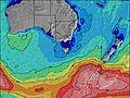 | 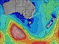 | 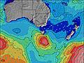 | 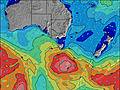 | ||||||||||||||
Wave Height (m) Direction Period (s) | SSE 13 | SE 12 | SE 12 | SSE 10 | SSE 10 | SSE 9 | ESE 17 | ESE 16 | ESE 15 | ESE 14 | ESE 14 | SSE 16 | SSE 16 | ESE 13 | ESE 14 | SE 9 | SE 11 | ESE 13 | ESE 13 | SSE 14 | SE 14 |
Wave Graph | |||||||||||||||||||||
67 | 41 | 34 | 20 | 9 | 13 | 27 | 50 | 42 | 41 | 19 | 24 | 49 | 35 | 41 | 65 | 55 | 70 | 34 | 40 | 49 | |
Wind (km/h) | |||||||||||||||||||||
Wind State on-shore cross-onshore cross-shore cross-offshore off-shore glassy | off | off | cross-off | cross-off | cross-off | cross-off | cross | cross | cross | cross-off | cross-off | off | off | off | cross-off | off | off | cross-off | cross-off | cross-off | cross-off |
High Tide | 4:44PM1.24m | 6:25AM0.87m | 5:24PM1.25m | 7:08AM0.89m | 6:06PM1.26m | 7:49AM0.91m | 6:49PM1.26m | 8:30AM0.93m | 7:32PM1.24m | 9:09AM0.95m | 8:16PM1.22m | 9:47AM0.96m | 9:01PM1.19m | ||||||||
Low Tide | 00:09AM0.45m | 10:42AM0.71m | 00:47AM0.40m | 11:32AM0.70m | 1:25AM0.34m | 12:24PM0.68m | 2:03AM0.30m | 1:15PM0.66m | 2:42AM0.26m | 2:05PM0.63m | 3:20AM0.25m | 2:54PM0.61m | 3:58AM0.26m | ||||||||
7:26 | — | — | 7:26 | — | — | 7:24 | — | — | 7:24 | — | — | 7:22 | — | — | 7:22 | — | — | 7:20 | — | — | |
— | 5:02 | — | — | 5:02 | — | — | 5:04 | — | — | 5:05 | — | — | 5:06 | — | — | 5:07 | — | — | 5:07 | — | |
mm | — | — | — | — | — | — | — | — | — | — | — | 12 | — | — | — | — | — | — | — | — | — |
Temp °C | 13 | 13 | 11 | 14 | 14 | 13 | 15 | 14 | 13 | 13 | 10 | 7 | 9 | 8 | 8 | 10 | 11 | 12 | 14 | 14 | 10 |
Feels °C | 9 | 10 | 7 | 9 | 10 | 9 | 11 | 10 | 8 | 8 | 4 | -1 | 3 | 2 | 2 | 4 | 6 | 8 | 9 | 10 | 7 |
Swell 1 Height (m) Direction Period (s) | SSE 8 | SSE 8 | SSE 7 | SSE 10 | SSE 10 | SSE 9 | ESE 17 | ESE 16 | NE 6 | NE 7 | SSE 6 | SE 6 | SE 6 | SE 6 | SE 7 | SE 9 | SE 11 | ESE 13 | ESE 13 | SSE 14 | SE 14 |
40 | 41 | 21 | 20 | 9 | 8 | 27 | 50 | 15 | 11 | 7 | 9 | 15 | 16 | 15 | 65 | 55 | 70 | 34 | 40 | 49 | |
Swell 2 Height (m) Direction Period (s) | SSE 13 | SE 12 | SE 12 | SE 13 | SE 13 | SE 14 | S 8 | S 14 | ESE 15 | ESE 14 | ESE 14 | ESE 13 | SSE 16 | ESE 13 | ESE 14 | SE 13 | ESE 13 | SSE 13 | SSE 14 | ESE 13 | ESE 13 |
67 | 40 | 34 | 7 | 7 | 8 | 1 | 4 | 42 | 41 | 19 | 17 | 49 | 35 | 41 | 45 | 16 | 17 | 18 | 34 | 16 | |
Swell 3 Height (m) Direction Period (s) | E 9 | — | SE 14 | — | E 20 | SE 18 | S 15 | S 8 | SSE 14 | NNW 3 | NE 7 | SSE 16 | ESE 13 | SSE 15 | SE 9 | S 14 | ESE 15 | S 6 | ESE 9 | SE 9 | SE 8 |
2 | — | 8 | — | 7 | 13 | 4 | 1 | 20 | 1 | 2 | 24 | 17 | 21 | 12 | 4 | 21 | 1 | 8 | 3 | 3 | |
Wind waves Height (m) Direction Period (s) | SW 3 | SW 3 | W 2 | WNW 2 | WSW 2 | WNW 2 | NW 2 | NNW 3 | N 3 | WSW 2 | W 2 | SW 3 | WSW 2 | — | W 3 | — | W 2 | W 2 | WNW 2 | — | — |
2 | 2 | 1 | 1 | 1 | 1 | 1 | 3 | 5 | 1 | 1 | 2 | 1 | — | 1 | — | 1 | 1 | 1 | — | — | |
Nearest Offshore or Glassy | |||||||||||||||||||||
Distance (km) | 0 | 0 | 25 | 25 | 25 | 41 | 41 | 41 | 41 | 41 | 25 | 30 | 0 | 0 | 25 | 25 | 0 | 0 | 25 | 0 | 0 |
Best forecast wave conditions in East Coast of Tasmania | |||||||||||||||||||||
Best forecast wave conditions in Australia | |||||||||||||||||||||
Header Global | |||||||||||||||||||||
- Map Icons:
 Break
Break Live Wave Height (m)
 Live Wind Speed (km/h)
 Surf Rating (10 Max)
 Ocean Swells (m)
- Wind Speed (km/h)


FREE! Surf-Forecast.com widget for your website
The surf report / weather widget below is available to embed on third party websites free of charge and provides a summary of our Shelly Point surf forecast. Simply grab the html code snippet that we provide and paste it into your own site. You can choose your preferred language and metric/imperial units for the surf forecast feed to suit users of your site. Click here to get the code.
Information about the Shelly Point Surf forecast
The above surf forecast table for Shelly Point provides essential information for determining whether the surfing conditions will be good over the next 16 days. A general guide to surfing at Shelly Point can be found by selecting the local surf guide option on the grey menu. Our Shelly Point surf forecast is unique since it includes wave energy (power) that defines the real feel of the surf rather than just the height or the period. If you surf the same spot (Shelly Point) regularly then make a mental note of the wave energy from the surf forecast table each time you go. Very soon you may start to choose your surf days based on the wave energy alone combined with our forecast of favourable offshore wind conditions. Our star ratings will help here and of course you will also find the usual wave height and period predictions on our surf forecasts as well as a full break down of the swell components under our advanced users option (to reveal that, click the little Einstein character under the tide times).
Further information to help with frequently asked questions about our surf forecast for Shelly Point may be found under the help tab on the top menu and also by moving your mouse over the question marks on the surf forecast table itself. Please always bear in mind that the forecast is for near-shore open water and local factors at each surf break influence the actual breaking wave height, such as the beach / reef profile, water depths offshore and shelter.
Are you planning a holiday in East Coast of Tasmania? If you are looking for accommodation near Shelly Point, camping, hotels and holiday cottages in East Coast of Tasmania, consider staying in Hobart which is 61 km (38 miles) away. Alternatively, find information about places to stay and car hire in Port Arthur which is 65 km (40 miles) away
 Nearest