

Surf Forecasts:

Rio Chico surf forecast from 1 Aug 2026:
- Most powerful swell: Friday 7 Aug, 10PM (local time) - 3.5ft (1.0m), 15s period, SW swell with 429 kJ wave energy.
Best Forecast Surf Conditions for Rio Chico this week:
The most powerful waves expected at Rio Chico in the next 16 days are 1.0m 15s and forecast to arrive on Friday (Aug 07) at 10PM. Winds are predicted to be cross-onshore at the time the swell arrives.
| Wave Type | Time (-05) & Date | Wave Height & Period |
|---|---|---|
| Next good surf (1 star+) | - | - |
| Best Surf | - | - |
| Most Powerful | 10PM (Fri 7th Aug) | 3.5ft (1.0m) 15s |
Table - best surf conditions forecast for Rio Chico over the next 16 days.
The Lowdown
Alright folks, Rusty here. Let’s have a look at what’s on the table for the next couple of weeks at Rio Chico. It’s been a bit of a quiet stretch, so don’t expect much action for the first week and a half. We’re mostly looking at small, weak swell with cross-onshore winds making things messy. The water is real warm, about 79°, and that’s nearly 9° warmer than usual for this time of year, so it’s like a bathtub out there.
For the first week, from Saturday the 1st right through to the morning of Thursday the 7th, the story is pretty flat. You’ll see tiny waves, mostly around 1 ft to 3 ft, but the wind is either onshore or cross-onshore, and the combined energy is weak, hovering around 100 to 300. The morning of Thursday the 7th shows a little bump – a 3 ft swell from the SW with a long 16-second period, and the energy kicks up to 464, but it’s still called marginal. The wind is light and onshore, so it’s not clean. Friday the 7th afternoon is a bit better, with a 3 ft SW swell and a 16-second period, energy up to 537. Still, it’s only marginal. The light onshore wind means it’s blown out.
The next week, from Saturday the 8th through to Sunday the 16th, doesn’t get much better. The swell stays small, mostly 2 ft to 3 ft, and the wind is mostly cross-onshore or onshore. The energy on the 14th of August Friday morning and afternoon finally gets some punch, with a 3 ft WSW swell, a long 18-second period, and energy reading 717 and 672. That’s the most interesting period of the whole window. The wind is light – still onshore – but it’s the biggest and most powerful swell we’ll see. The 15th of August Saturday morning also has a 3 ft WSW swell with a 16-second period and energy at 553. It’s still marginal, but it’s the closest we get to anything rideable.
To be honest, there’s no standout day here. The best bet is the morning of the 14th of August and the 15th of August, but even then, the wind is not ideal. The swell is coming from the SW to WSW, which is the optimum direction for this spot, but the period is long, so it’ll be a bit fat and sectiony at this point break. The energy is moderate to strong on those days, but the onshore/cross-onshore wind will keep it messy. Crowds are possible at Rio Chico, so if you’re desperate, you might share a few waves.
Overall, it’s a lean run. For a spot that’s this consistent, this is a quiet spell. Hang tight, the forecasts can change.
Rusty.
Short Range ForecastSome drizzle, heaviest during Mon night. Warm (max 25°C on Sat morning, min 23°C on Sat night). Wind will be generally light. | Days 4-6 Weather SummaryMostly dry. Warm (max 25°C on Tue morning, min 23°C on Tue afternoon). Wind will be generally light. | ||||||||||||||||||||
Saturday 1 | Sunday 2 | Monday 3 | Tuesday 4 | Wednesday 5 | Thursday 6 | Friday 7 | |||||||||||||||
AM | PM | Night | AM | PM | Night | AM | PM | Night | AM | PM | Night | AM | PM | Night | AM | PM | Night | AM | PM | Night | |
Swell Height Map | 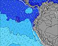 | 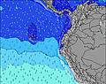 | 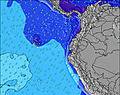 | 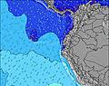 | 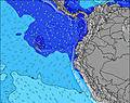 | 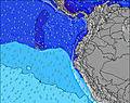 | 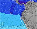 | ||||||||||||||
Wave Height (m) Direction Period (s) | SW 12 | WSW 11 | WSW 12 | WSW 11 | WSW 14 | WSW 13 | WSW 13 | WSW 13 | SW 9 | SW 12 | SW 12 | SW 14 | SW 12 | SW 14 | SW 13 | SW 13 | SW 13 | SW 17 | SW 16 | SW 16 | SW 15 |
Wave Graph | |||||||||||||||||||||
140 | 100 | 125 | 90 | 131 | 118 | 114 | 108 | 101 | 69 | 35 | 51 | 120 | 102 | 295 | 286 | 265 | 290 | 306 | 416 | 418 | |
Wind (km/h) | |||||||||||||||||||||
Wind State on-shore cross-onshore cross-shore cross-offshore off-shore glassy | on | on | cross-on | cross-on | on | cross-on | cross-on | on | cross-on | cross-on | on | cross-on | cross-on | on | cross-on | cross-on | on | cross-on | on | on | cross-on |
High Tide | 5:38PM2.10m | 6:06AM2.28m | 6:15PM2.08m | 6:38AM2.26m | 6:54PM2.03m | 7:14AM2.22m | 7:37PM1.97m | 7:55AM2.15m | 8:28PM1.89m | 8:44AM2.06m | 9:30PM1.82m | 9:45AM1.98m | 10:46PM1.80m | ||||||||
Low Tide | 11:43AM0.46m | 11:48PM0.29m | 12:18PM0.43m | 00:21AM0.35m | 12:54PM0.43m | 00:58AM0.42m | 1:34PM0.44m | 1:38AM0.52m | 2:20PM0.46m | 2:27AM0.62m | 3:15PM0.50m | 3:28AM0.72m | 4:21PM0.51m | ||||||||
6:28 | — | — | 6:28 | — | — | 6:28 | — | — | 6:28 | — | — | 6:26 | — | — | 6:26 | — | — | 6:26 | — | — | |
— | 6:30 | — | — | 6:30 | — | — | 6:30 | — | — | 6:30 | — | — | 6:30 | — | — | 6:30 | — | — | 6:30 | — | |
mm | — | — | — | — | — | — | — | — | 1 | — | — | — | — | — | — | — | — | — | — | — | — |
Temp °C | 25 | 25 | 24 | 24 | 24 | 23 | 25 | 24 | 23 | 25 | 24 | 23 | 25 | 25 | 24 | 25 | 25 | 24 | 25 | 25 | 24 |
Feels °C | 28 | 27 | 27 | 26 | 25 | 25 | 27 | 25 | 25 | 27 | 26 | 25 | 28 | 27 | 27 | 27 | 27 | 27 | 28 | 27 | 26 |
Swell 1 Height (m) Direction Period (s) | SSW 7 | SW 7 | WSW 12 | SSW 7 | SW 11 | WSW 13 | WSW 13 | SW 6 | SW 9 | SSW 6 | SW 12 | WSW 11 | SW 12 | SSW 8 | SW 13 | SW 13 | SW 13 | SW 12 | SW 16 | SW 16 | SW 15 |
96 | 69 | 125 | 90 | 110 | 118 | 114 | 37 | 95 | 20 | 35 | 51 | 120 | 43 | 295 | 286 | 265 | 209 | 306 | 416 | 418 | |
Swell 2 Height (m) Direction Period (s) | SW 12 | WSW 11 | WSW 15 | WSW 11 | WSW 14 | SW 10 | SW 10 | WSW 13 | WSW 12 | SW 12 | SW 14 | SW 14 | SW 8 | SW 14 | SW 18 | SW 19 | SW 18 | SW 17 | SW 12 | SW 12 | NW 9 |
140 | 84 | 86 | 82 | 131 | 47 | 34 | 108 | 101 | 69 | 33 | 46 | 17 | 102 | 54 | 127 | 111 | 290 | 147 | 110 | 3 | |
Swell 3 Height (m) Direction Period (s) | SW 16 | WSW 16 | N 5 | WSW 15 | WNW 12 | WNW 10 | WNW 11 | SW 10 | WNW 11 | SW 9 | SW 9 | SSW 8 | SW 20 | SW 12 | NW 9 | W 13 | W 13 | W 12 | W 12 | W 12 | — |
66 | 100 | 1 | 84 | 13 | 11 | 12 | 33 | 11 | 39 | 12 | 7 | 15 | 66 | 3 | 14 | 3 | 11 | 11 | 11 | — | |
Wind waves Height (m) Direction Period (s) | — | — | SW 6 | — | SW 7 | SW 7 | SSW 6 | — | — | — | SW 6 | SW 5 | SW 5 | SW 5 | — | — | — | — | — | — | — |
— | — | 59 | — | 52 | 79 | 44 | — | — | — | 26 | 22 | 13 | 13 | — | — | — | — | — | — | — | |
Nearest Offshore or Glassy | |||||||||||||||||||||
Distance (km) | 273 | 991 | 224 | 62 | 781 | 173 | 62 | 738 | 33 | 62 | 781 | 62 | 62 | 62 | 62 | 62 | 62 | 33 | 62 | 935 | 33 |
Best forecast wave conditions in Manabi | |||||||||||||||||||||
Best forecast wave conditions in Ecuador | |||||||||||||||||||||
Header Global | |||||||||||||||||||||
- Map Icons:
 Break
Break Live Wave Height (m)
 Live Wind Speed (km/h)
 Surf Rating (10 Max)
 Ocean Swells (m)
- Wind Speed (km/h)
Latest Updates


FREE! Surf-Forecast.com widget for your website
The surf report / weather widget below is available to embed on third party websites free of charge and provides a summary of our Rio Chico surf forecast. Simply grab the html code snippet that we provide and paste it into your own site. You can choose your preferred language and metric/imperial units for the surf forecast feed to suit users of your site. Click here to get the code.
Information about the Rio Chico Surf forecast
The above surf forecast table for Rio Chico provides essential information for determining whether the surfing conditions will be good over the next 16 days. A general guide to surfing at Rio Chico can be found by selecting the local surf guide option on the grey menu. Our Rio Chico surf forecast is unique since it includes wave energy (power) that defines the real feel of the surf rather than just the height or the period. If you surf the same spot (Rio Chico) regularly then make a mental note of the wave energy from the surf forecast table each time you go. Very soon you may start to choose your surf days based on the wave energy alone combined with our forecast of favourable offshore wind conditions. Our star ratings will help here and of course you will also find the usual wave height and period predictions on our surf forecasts as well as a full break down of the swell components under our advanced users option (to reveal that, click the little Einstein character under the tide times).
Further information to help with frequently asked questions about our surf forecast for Rio Chico may be found under the help tab on the top menu and also by moving your mouse over the question marks on the surf forecast table itself. Please always bear in mind that the forecast is for near-shore open water and local factors at each surf break influence the actual breaking wave height, such as the beach / reef profile, water depths offshore and shelter.
Rio Chico is 45 km (28 miles) from Jipijapa. If you plan a holiday in Manabi, look for hotels and other accommodation in Jipijapa. Jipijapa has rooms for a wide range of budgets as well as car hire and transport links.
 Nearest