

Surf Forecasts:

Punta de Lobos surf forecast from 19 Jul 2026:
- Best quality surf: Friday 24 Jul, 2AM (local time) - 6ft (1.9m), 12s period, WSW swell with offshore winds.
- Most powerful swell: Friday 24 Jul, 5AM (local time) - 7ft (2.2m), 12s period, WSW swell with 1,251 kJ wave energy.
- Next surfable swell (1★+): Sunday 19 Jul, 11AM (local time) - 5ft (1.5m), 11s period with WNW swell.
Best Forecast Surf Conditions for Punta de Lobos this week:
The surf forecast for Punta de Lobos over the next 16 days: The first swell (rated 1 star or higher) is forecast to arrive on Sunday (Jul 19) at 11AM. The primary swell is predicted to be 1.5m and 11s period with a secondary swell of 0.9m and 11s. The wind is predicted to be glassy as the swell arrives.
The most powerful waves expected at Punta de Lobos in the next 16 days are 2.2m 12s and forecast to arrive on Friday (Jul 24) at 5AM. Winds are predicted to be offshore at the time the swell arrives. The largest open ocean swell (not directed at the beach) is 3.0m 8s period and expected on Tuesday (Jul 21) at 5PM.
| Wave Type | Time (-04) & Date | Wave Height & Period |
|---|---|---|
| Next good surf (1 star+) | 11AM (Sun 19th Jul) | 5ft (1.5m) 11s |
| Best Surf | 2AM (Fri 24th Jul) | 6ft (1.9m) 12s |
| Most Powerful | 5AM (Fri 24th Jul) | 7ft (2.2m) 12s |
Table - best surf conditions forecast for Punta de Lobos over the next 16 days.
The Lowdown
Alright folks, Rusty here with a long look at what's coming our way for Punta de Lobos. We've got a mixed bag over the next couple of weeks, but there are some proper sessions to get excited about. The water’s sitting at 55°F, which is pretty much what you’d expect for this time of year.
The first real action kicks off this Sunday morning, the 19th of July. It’s looking glassy with that 3 mph ESE breeze, and we’ve got a solid 5ft swell rolling in from the WNW with an 11-second period. The combined energy is a decent 676 (moderate wave energy), laying down some clean lines. This is a good one to get the board wet.
We hit a bit of a lull with messy winds and smaller swell through Monday and Tuesday, but things really start to build again. Wednesday the 22nd of July is a standout. The afternoon session is calling my name – glassy conditions again, with a 6ft WNW swell and an 11-second period. That energy bumps up to 765 (moderate wave energy). A clean, lined-up Punta de Lobos on a glassy day is a treat.
Then, hold onto your wetsuits, because Friday the 24th of July is the pick of the whole forecast. Both the morning and afternoon are firing. We’re looking at a 7ft WNW swell in the morning, with glassy conditions and an 11-second period. The combined energy hits 1166 (strong wave energy). The afternoon is almost as good with a 6ft wave and clean cross-off winds from the east. This is for experienced surfers only – that’s a proper swell size, and the energy is pumping.
Saturday morning the 25th is still fun, with a smaller 4ft swell and clean conditions. After that, late July and into early August brings a lot of cross-shore wind and bigger, more unruly swell. You’ll see some big numbers – like on Monday the 27th of July with 8ft and strong energy at 1697 (strong wave energy) – but it’s going to be bumpy with that northerly wind. That kind of setup looks more interesting for the kite-surfing crew than for a clean paddle session.
Later on, the swell sticks around but it’s battling the wind. Look at the 31st of July and the 1st of August – we’re talking 8ft and 10ft waves from the WNW, with energy readings over 2000 (very strong wave energy), but the wind is just messy. There's potential for an expert-only paddle if you’re desperate for a big, raw wave, just don’t expect any perfection.
So, to sum it up: your best bets are this Sunday morning the 19th for a nice glassy session, and Friday the 24th of July for a proper, powerful day that will have you grinning. The second week is full of size but lacks the clean conditions to really make it shine.
That’s the story from here.
Rusty
Short Range ForecastHeavy rain (total 39mm), heaviest during Tue morning. Very mild (max 14°C on Sun afternoon, min 10°C on Sun morning). Winds increasing (calm on Sun morning, strong winds from the N by Tue afternoon). | Days 4-6 Weather SummaryMostly dry. Very mild (max 16°C on Fri afternoon, min 12°C on Wed morning). Wind will be generally light. | ||||||||||||||||||||
Sunday 19 | Monday 20 | Tuesday 21 | Wednesday 22 | Thursday 23 | Friday 24 | Saturday 25 | |||||||||||||||
AM | PM | Night | AM | PM | Night | AM | PM | Night | AM | PM | Night | AM | PM | Night | AM | PM | Night | AM | PM | Night | |
Swell Height Map | 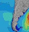 |  |  | 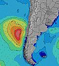 | 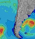 | 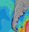 | 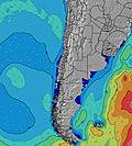 | ||||||||||||||
Wave Height (m) Direction Period (s) | WNW 11 | W 11 | W 11 | W 11 | W 11 | W 11 | W 11 | W 10 | W 10 | WNW 11 | WNW 11 | WNW 10 | W 9 | W 9 | WSW 12 | W 11 | W 11 | WSW 10 | W 11 | WSW 15 | WSW 14 |
Wave Graph | |||||||||||||||||||||
494 | 396 | 350 | 303 | 246 | 154 | 83 | 56 | 73 | 885 | 705 | 386 | 203 | 162 | 985 | 1084 | 846 | 735 | 375 | 288 | 334 | |
Wind (km/h) | |||||||||||||||||||||
Wind State on-shore cross-onshore cross-shore cross-offshore off-shore glassy | glassy | cross | cross-on | cross-off | off | cross-off | cross-on | cross | cross | cross | glassy | glassy | cross | cross-off | off | glassy | cross-off | cross-off | cross-off | cross | cross-off |
High Tide | 2:03PM1.27m | 2:52AM1.08m | 2:50PM1.10m | 3:46AM1.08m | 3:44PM0.94m | 4:47AM1.09m | 4:52PM0.82m | 5:53AM1.11m | 6:17PM0.76m | 6:57AM1.15m | 7:38PM0.75m | 7:52AM1.20m | 8:36PM0.78m | ||||||||
Low Tide | 8:36PM0.14m | 8:49AM0.35m | 9:18PM0.24m | 10:00AM0.43m | 10:03PM0.32m | 11:24AM0.47m | 10:56PM0.39m | 12:51PM0.45m | 11:57PM0.43m | 2:00PM0.39m | 00:58AM0.43m | 2:52PM0.33m | 1:52AM0.40m | ||||||||
7:50 | — | — | 7:48 | — | — | 7:48 | — | — | 7:48 | — | — | 7:48 | — | — | 7:47 | — | — | 7:46 | — | — | |
— | 5:58 | — | — | 5:59 | — | — | 6:00 | — | — | 6:00 | — | — | 6:00 | — | — | 6:01 | — | — | 6:01 | — | |
mm | — | — | 7 | 2 | — | 3 | 15 | 6 | 6 | — | — | — | — | — | — | — | — | — | — | — | — |
Temp °C | 13 | 14 | 12 | 10 | 12 | 12 | 12 | 13 | 14 | 14 | 15 | 12 | 14 | 14 | 14 | 14 | 16 | 16 | 17 | 18 | 15 |
Feels °C | 12 | 12 | 11 | 8 | 8 | 8 | 7 | 3 | 6 | 11 | 13 | 11 | 13 | 13 | 12 | 12 | 13 | 14 | 16 | 17 | 14 |
Swell 1 Height (m) Direction Period (s) | WNW 11 | W 11 | W 11 | W 11 | W 11 | W 11 | W 11 | W 10 | W 10 | WNW 11 | WNW 11 | WNW 10 | W 9 | W 9 | WSW 12 | W 11 | W 11 | WSW 10 | W 11 | W 9 | W 9 |
494 | 396 | 350 | 303 | 246 | 154 | 83 | 56 | 73 | 885 | 705 | 386 | 203 | 162 | 985 | 1084 | 846 | 735 | 375 | 280 | 334 | |
Swell 2 Height (m) Direction Period (s) | SW 11 | SSW 11 | SW 11 | SW 11 | SSW 10 | SW 10 | SW 10 | SW 10 | SW 14 | N 7 | N 7 | SSW 11 | SW 10 | SW 18 | SW 18 | SW 21 | SW 21 | WSW 16 | WSW 10 | WSW 10 | WSW 14 |
182 | 160 | 172 | 94 | 73 | 82 | 48 | 25 | 65 | 127 | 44 | 45 | 26 | 51 | 50 | 71 | 150 | 151 | 171 | 204 | 289 | |
Swell 3 Height (m) Direction Period (s) | N 7 | NNW 6 | NW 11 | SW 6 | SW 6 | N 8 | WNW 10 | SW 15 | WSW 25 | SW 12 | SW 11 | SW 20 | SW 20 | SSW 10 | W 19 | SW 17 | WSW 18 | SW 20 | WSW 15 | WSW 15 | SW 10 |
37 | 14 | 5 | 17 | 14 | 11 | 10 | 9 | 61 | 69 | 60 | 102 | 60 | 10 | 7 | 11 | 62 | 61 | 186 | 288 | 79 | |
Wind waves Height (m) Direction Period (s) | — | — | — | NNE 6 | — | N 4 | N 6 | N 8 | NNW 8 | — | — | — | — | — | — | — | — | — | — | — | — |
— | — | — | 3 | — | 19 | 261 | 1385 | 744 | — | — | — | — | — | — | — | — | — | — | — | — | |
Nearest Offshore or Glassy | |||||||||||||||||||||
Distance (km) | 0 | 6 | 54 | 0 | 0 | 0 | 175 | 211 | 96 | 1 | 0 | 0 | 1 | 0 | 0 | 0 | 0 | 0 | 0 | 6 | 0 |
Best forecast wave conditions in Santiago | |||||||||||||||||||||
Best forecast wave conditions in Chile | |||||||||||||||||||||
Header Global | |||||||||||||||||||||
- Map Icons:
 Break
Break Live Wave Height (m)
 Live Wind Speed (km/h)
 Surf Rating (10 Max)
 Ocean Swells (m)
- Wind Speed (km/h)


FREE! Surf-Forecast.com widget for your website
The surf report / weather widget below is available to embed on third party websites free of charge and provides a summary of our Punta de Lobos surf forecast. Simply grab the html code snippet that we provide and paste it into your own site. You can choose your preferred language and metric/imperial units for the surf forecast feed to suit users of your site. Click here to get the code.
Information about the Punta de Lobos Surf forecast
The above surf forecast table for Punta de Lobos provides essential information for determining whether the surfing conditions will be good over the next 16 days. A general guide to surfing at Punta de Lobos can be found by selecting the local surf guide option on the grey menu. Our Punta de Lobos surf forecast is unique since it includes wave energy (power) that defines the real feel of the surf rather than just the height or the period. If you surf the same spot (Punta de Lobos) regularly then make a mental note of the wave energy from the surf forecast table each time you go. Very soon you may start to choose your surf days based on the wave energy alone combined with our forecast of favourable offshore wind conditions. Our star ratings will help here and of course you will also find the usual wave height and period predictions on our surf forecasts as well as a full break down of the swell components under our advanced users option (to reveal that, click the little Einstein character under the tide times).
Further information to help with frequently asked questions about our surf forecast for Punta de Lobos may be found under the help tab on the top menu and also by moving your mouse over the question marks on the surf forecast table itself. Please always bear in mind that the forecast is for near-shore open water and local factors at each surf break influence the actual breaking wave height, such as the beach / reef profile, water depths offshore and shelter.
Punta de Lobos is 67 km (42 miles) from Santa Cruz. If you plan a holiday in Santiago, look for hotels and other accommodation in Santa Cruz. Santa Cruz has rooms for a wide range of budgets as well as car hire and transport links.
 Nearest