

Surf Forecasts:

Portonovo (la Nave) surf forecast from 22 Jul 2026:
- Best quality surf: Monday 27 Jul, 5AM (local time) - 3.5ft (1.1m), 7s period, E swell with cross-offshore winds.
- Most powerful swell: Monday 27 Jul, 2AM (local time) - 4ft (1.2m), 7s period, E swell with 156 kJ wave energy.
- Next surfable swell (1★+): Monday 27 Jul, 5AM (local time) - 3.5ft (1.1m), 7s period with E swell.
Best Forecast Surf Conditions for Portonovo (la Nave) this week:
The surf forecast for Portonovo (la Nave) over the next 16 days: The first swell (rated 1 star or higher) is forecast to arrive on Monday (Jul 27) at 5AM. The primary swell is predicted to be 1.1m and 7s period. The wind is predicted to be cross-offshore as the swell arrives.
The most powerful waves expected at Portonovo (la Nave) in the next 16 days are 1.2m 7s and forecast to arrive on Monday (Jul 27) at 2AM. Winds are predicted to be cross-shore at the time the swell arrives. The largest open ocean swell (not directed at the beach) is 0.7m 5s period and expected on Friday (Jul 24) at 2PM.
| Wave Type | Time (CEST) & Date | Wave Height & Period |
|---|---|---|
| Next good surf (1 star+) | 5AM (Mon 27th Jul) | 3.5ft (1.1m) 7s |
| Best Surf | 5AM (Mon 27th Jul) | 3.5ft (1.1m) 7s |
| Most Powerful | 2AM (Mon 27th Jul) | 4ft (1.2m) 7s |
Table - best surf conditions forecast for Portonovo (la Nave) over the next 16 days.
The Lowdown
Alright folks, Rusty here. Let's have a look at what's on the menu for the next couple of weeks.
This is a tough one to write, because frankly, for the next 16 days, there's not a single standout session on offer. We're looking at a long stretch of mostly flat or poor conditions. The only flicker of something surfable shows up right at the end of the first week, before the swell fades out again.
The only real spot on the radar here is Portonovo (la Nave), a point break that's mostly for beginners. It's inconsistent and rarely breaks, so this is a spot that needs a lot of things to line up. The water is a notable 82°F right now, which is *much warmer than normal* for the time of year—over five degrees warmer than average, which is very unusual.
The first week is a write-off. From Wednesday 22nd right through to Sunday 26th, the energy is barely there, with combined swell energy readings of just 8 and 1, and the comments are all "poor surf conditions." The wind is all over the place, and the swell is tiny and short-period. It's just not happening.
Monday 27th July is the best we get. It's not great, but it's something. The morning brings a glassy, calm surface with a 3ft swell from the east, with a period of 7 seconds. The combined energy reaches 109 (moderate), so there's a little more push. The conditions are "surfable waves but very ordinary." It's a small, clean wave for a beginner on a point break, but it's not going to blow anyone's mind.
After that, Tuesday 28th July morning has a similar feel—glassy, 3ft from the NNE, but the energy drops back to 73 (weak). Then it's back to the doldrums. From Wednesday 29th right through to Thursday 6th August, the swell is either non-existent or tiny, with the combined energy often at 0. There are long gaps of nothing. The winds are mostly cross-off or glassy, but without any swell, it's flat. The water stays warm, but that's not much comfort.
So, to call it: the best on offer is the morning of Monday 27th July at Portonovo (la Nave). It's a small, clean, weak wave. If you're a beginner, it's a chance to get wet. If you're after anything with more punch, you're better off waiting for the next system. Don't hold your breath.
Rusty.
Short Range ForecastSome drizzle, heaviest during Thu night. Warm (max 26°C on Thu morning, min 21°C on Fri night). Wind will be generally light. | Days 5-7 Weather SummaryMostly dry. Warm (max 29°C on Sun afternoon, min 23°C on Sat night). Winds decreasing (fresh winds from the SE on Sat afternoon, calm by Mon morning). | |||||||||||||||||||
Wed 22 | Thursday 23 | Friday 24 | Saturday 25 | Sunday 26 | Monday 27 | Tuesday 28 | ||||||||||||||
PM | Night | AM | PM | Night | AM | PM | Night | AM | PM | Night | AM | PM | Night | AM | PM | Night | AM | PM | Night | |
Swell Height Map | 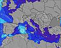 | 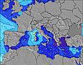 | 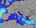 | 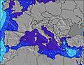 | 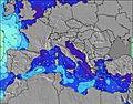 | 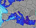 | 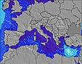 | |||||||||||||
Wave Height (m) Direction Period (s) | NE 4 | NNE 4 | NNE 3 | E 4 | — | N 4 | NE 5 | NNE 4 | — | ESE 3 | SE 4 | ESE 5 | E 6 | E 7 | E 7 | ESE 7 | ESE 7 | NNE 6 | NNE 5 | N 4 |
Wave Graph | ||||||||||||||||||||
7 | 3 | 1 | 1 | 0 | 0 | 50 | 1 | 0 | 3 | 11 | 13 | 39 | 156 | 109 | 71 | 36 | 65 | 42 | 13 | |
Wind (km/h) | ||||||||||||||||||||
Wind State on-shore cross-onshore cross-shore cross-offshore off-shore glassy | on | cross-off | cross-off | cross-on | cross-on | cross-on | cross-on | cross-off | cross-off | cross | cross-off | glassy | cross-on | cross | glassy | on | cross-on | glassy | on | cross-off |
High Tide | 4:47PM0.40m | 4:54PM0.39m | 4:59PM0.38m | 4:14PM0.37m | 2:54PM0.37m | 2:38PM0.37m | 8:06PM0.35m | 2:40PM0.38m | 9:08PM0.35m | |||||||||||
Low Tide | 3:17AM0.10m | 3:50AM0.09m | 4:24AM0.07m | 4:56AM0.06m | 5:26AM0.04m | 7:11PM0.35m | 5:53AM0.03m | 7:28PM0.34m | ||||||||||||
— | — | 5:45 | — | — | 5:45 | — | — | 5:46 | — | — | 5:47 | — | — | 5:48 | — | — | 5:50 | — | — | |
8:38 | — | — | 8:37 | — | — | 8:37 | — | — | 8:36 | — | — | 8:35 | — | — | 8:34 | — | — | 8:32 | — | |
mm | — | — | — | — | 1 | — | — | — | — | — | — | — | — | — | — | — | — | — | — | — |
Temp °C | 25 | 25 | 26 | 26 | 23 | 25 | 25 | 24 | 26 | 27 | 25 | 27 | 29 | 27 | 27 | 28 | 27 | 27 | 28 | 27 |
Feels °C | 23 | 26 | 23 | 23 | 23 | 21 | 22 | 23 | 21 | 22 | 21 | 28 | 29 | 26 | 30 | 29 | 30 | 29 | 29 | 30 |
Swell 1 Height (m) Direction Period (s) | ENE 4 | NNE 4 | NNE 3 | — | — | N 4 | ENE 5 | NNE 4 | — | — | — | ESE 5 | E 6 | E 7 | E 7 | ESE 7 | ESE 7 | ESE 6 | ENE 5 | SE 6 |
1 | 3 | 1 | — | — | 7 | 26 | 1 | — | — | — | 13 | 39 | 156 | 109 | 71 | 26 | 8 | 7 | 1 | |
Swell 2 Height (m) Direction Period (s) | — | — | — | — | — | — | N 5 | E 4 | — | — | — | — | — | — | — | — | ESE 7 | — | ENE 6 | — |
— | — | — | — | — | — | 29 | 1 | — | — | — | — | — | — | — | — | 36 | — | 3 | — | |
Swell 3 Height (m) Direction Period (s) | — | — | — | — | — | — | — | — | — | — | — | — | — | — | — | — | — | — | ESE 6 | — |
— | — | — | — | — | — | — | — | — | — | — | — | — | — | — | — | — | — | 4 | — | |
Wind waves Height (m) Direction Period (s) | NE 4 | — | — | E 4 | — | — | NE 5 | — | — | ESE 3 | SE 4 | — | — | — | — | NNW 4 | NNE 5 | NNE 6 | NNE 5 | N 4 |
7 | — | — | 1 | — | — | 50 | — | — | 3 | 11 | — | — | — | — | 11 | 36 | 65 | 42 | 13 | |
Nearest Offshore or Glassy | ||||||||||||||||||||
Distance (km) | 1421 | 740 | 748 | 1421 | 1174 | 437 | 1682 | 679 | 999 | 1841 | 57 | 253 | 603 | 57 | 0 | 440 | 48 | 0 | 1237 | 122 |
Best forecast wave conditions in Adriatic - Italy | ||||||||||||||||||||
Best forecast wave conditions in Italy | ||||||||||||||||||||
Header Global | ||||||||||||||||||||
- Map Icons:
 Break
Break Live Wave Height (m)
 Live Wind Speed (km/h)
 Surf Rating (10 Max)
 Ocean Swells (m)
- Wind Speed (km/h)


FREE! Surf-Forecast.com widget for your website
The surf report / weather widget below is available to embed on third party websites free of charge and provides a summary of our Portonovo (la Nave) surf forecast. Simply grab the html code snippet that we provide and paste it into your own site. You can choose your preferred language and metric/imperial units for the surf forecast feed to suit users of your site. Click here to get the code.
Information about the Portonovo (la Nave) Surf forecast
The above surf forecast table for Portonovo (la Nave) provides essential information for determining whether the surfing conditions will be good over the next 16 days. A general guide to surfing at Portonovo (la Nave) can be found by selecting the local surf guide option on the grey menu. Our Portonovo (la Nave) surf forecast is unique since it includes wave energy (power) that defines the real feel of the surf rather than just the height or the period. If you surf the same spot (Portonovo (la Nave)) regularly then make a mental note of the wave energy from the surf forecast table each time you go. Very soon you may start to choose your surf days based on the wave energy alone combined with our forecast of favourable offshore wind conditions. Our star ratings will help here and of course you will also find the usual wave height and period predictions on our surf forecasts as well as a full break down of the swell components under our advanced users option (to reveal that, click the little Einstein character under the tide times).
Further information to help with frequently asked questions about our surf forecast for Portonovo (la Nave) may be found under the help tab on the top menu and also by moving your mouse over the question marks on the surf forecast table itself. Please always bear in mind that the forecast is for near-shore open water and local factors at each surf break influence the actual breaking wave height, such as the beach / reef profile, water depths offshore and shelter.
Portonovo (la Nave) is 9 km (6 miles) from the city of Pinocchio di Ancona. If you plan a holiday in Adriatic - Italy, look for hotels and other accommodation in Pinocchio di Ancona. Pinocchio di Ancona has rooms for a wide range of budgets as well as car hire and transport links.
 Nearest