

Surf Forecasts:

How big are the waves at Penarol today (20 Jun):
- Morning surf: Morning surf (20 Jun, local time) - 3.5ft (1.0m), 16s period with SSW swell.
- Afternoon surf: Afternoon surf (20 Jun, local time) - 3.5ft (1.1m), 14s period with SW swell.
- Evening surf: Evening surf (20 Jun, local time) - 3.5ft (1.0m), 13s period with SSW swell.
The current surf forecast for Penarol at 2PM is: 1.2m 15s primary swell from a South-southwest direction and 1.5m 7s secondary swell from a South-southwest direction (forecast issued at 07:00am June 20). The wind direction is predicted to be cross-onshore.
| Time (-04) & Date | Wave Height | Wave Period |
|---|---|---|
| Morning (20 Jun) | 3.5ft (1.0m) | 16s |
| Afternoon (20 Jun) | 3.5ft (1.1m) | 14s |
| Evening (20 Jun) | 3.5ft (1.0m) | 13s |
Table - waves today at Penarol. (Swell directed towards the surf break)
Updates in hr min s Forecast update imminent
Short Range ForecastMostly dry. Very mild (max 16°C on Sat morning, min 14°C on Sun morning). Wind will be generally light. | ||||||||||||||||||||||||
Saturday 20 | Sunday 21 | Monday 22 | Tue 23 | |||||||||||||||||||||
5 AM | 8 AM | 11 AM | 2 PM | 5 PM | 8 PM | 11 PM | 2 AM | 5 AM | 8 AM | 11 AM | 2 PM | 5 PM | 8 PM | 11 PM | 2 AM | 5 AM | 8 AM | 11 AM | 2 PM | 5 PM | 8 PM | 11 PM | 2 AM | |
Swell Height Map |  |  | 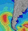 |  |  |  |  | 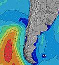 |  |  | ||||||||||||||
Wave Height (m) Direction Period (s) | SSW 16 | SSW 16 | SSW 15 | SSW 15 | SSW 14 | SSW 13 | SSW 13 | SSW 13 | SW 20 | SW 19 | SSW 19 | SW 19 | SSW 18 | SSW 18 | SW 18 | SSW 17 | SSW 16 | SSW 16 | SSW 16 | SSW 16 | SSW 15 | SSW 15 | SSW 14 | SSW 14 |
Wave Graph | ||||||||||||||||||||||||
334 | 441 | 480 | 568 | 402 | 373 | 357 | 355 | 469 | 1100 | 2023 | 3065 | 3535 | 4580 | 4996 | 5110 | 5027 | 7680 | 6970 | 6494 | 6085 | 5270 | 4820 | 4258 | |
Wind (km/h) | ||||||||||||||||||||||||
Wind State on-shore cross-onshore cross-shore cross-offshore off-shore glassy | cross | cross | cross-on | cross-on | cross-on | glassy | cross | cross | cross | cross | cross | cross | cross | cross | cross | cross | cross | cross | cross | cross | cross | cross | cross | cross |
High Tide | 1:40PM1.16m | 2:43AM0.81m | 2:33PM1.04m | 3:45AM0.86m | 3:29PM0.92m | |||||||||||||||||||
Low Tide | 7:09AM0.22m | 8:33PM0.05m | 8:17AM0.29m | 9:22PM0.09m | 9:33AM0.34m | 10:09PM0.14m | ||||||||||||||||||
7:22 | — | — | — | — | — | — | — | 7:22 | — | — | — | — | — | — | — | 7:22 | — | — | — | — | — | — | 7:22 | |
— | — | — | — | 6:04 | — | — | — | — | — | — | — | 6:04 | — | — | — | — | — | — | — | 6:05 | — | — | 6:05 | |
mm | — | — | — | — | — | — | — | — | — | — | — | — | — | — | — | — | — | — | — | — | — | — | — | — |
Temp °C | 15 | 15 | 16 | 16 | 16 | 15 | 15 | 15 | 15 | 14 | 15 | 15 | 15 | 14 | 14 | 14 | 14 | 14 | 15 | 16 | 15 | 15 | 15 | 14 |
Feels °C | 12 | 14 | 16 | 16 | 16 | 15 | 15 | 14 | 13 | 12 | 13 | 11 | 11 | 9 | 10 | 10 | 9 | 10 | 12 | 12 | 12 | 12 | 13 | 12 |
Swell 1 Height (m) Direction Period (s) | SSW 16 | SSW 7 | SSW 7 | SSW 7 | SSW 8 | SSW 8 | SSW 8 | SSW 8 | SSW 8 | SSW 8 | SSW 19 | SW 19 | SSW 18 | SSW 18 | SW 18 | SSW 17 | SSW 16 | SSW 16 | SSW 16 | SSW 16 | SSW 15 | SSW 15 | SSW 14 | SSW 14 |
334 | 243 | 224 | 237 | 213 | 219 | 204 | 198 | 209 | 220 | 2023 | 3065 | 3535 | 4580 | 4996 | 5110 | 5027 | 7680 | 6970 | 6494 | 6085 | 5270 | 4820 | 4258 | |
Swell 2 Height (m) Direction Period (s) | SW 13 | SSW 16 | SSW 15 | SSW 15 | SSW 14 | SSW 13 | SSW 13 | SSW 13 | SSW 12 | SW 19 | SSW 12 | SSW 11 | SSW 11 | SSW 9 | SSW 9 | SSW 10 | — | — | — | — | SW 11 | SW 15 | SW 14 | SW 14 |
178 | 441 | 480 | 568 | 402 | 373 | 357 | 330 | 255 | 1100 | 698 | 726 | 742 | 660 | 800 | 1057 | — | — | — | — | 538 | 2491 | 573 | 776 | |
Swell 3 Height (m) Direction Period (s) | SSW 10 | SW 13 | SW 13 | WSW 13 | SW 12 | WSW 12 | WSW 12 | SW 21 | SW 20 | SW 12 | WSW 12 | WNW 13 | WNW 13 | WNW 13 | WNW 13 | WNW 13 | — | — | — | — | — | — | SSW 14 | — |
42 | 178 | 175 | 99 | 159 | 99 | 58 | 355 | 469 | 278 | 53 | 17 | 17 | 17 | 17 | 17 | — | — | — | — | — | — | 325 | — | |
Wind waves Height (m) Direction Period (s) | SSW 7 | — | — | — | — | — | — | — | — | — | — | — | — | — | — | — | SSW 10 | — | — | — | — | — | — | — |
198 | — | — | — | — | — | — | — | — | — | — | — | — | — | — | — | 1193 | — | — | — | — | — | — | — | |
Nearest Offshore or Glassy | ||||||||||||||||||||||||
Distance (km) | 63 | 3 | 187 | 187 | 63 | 0 | 13 | 3 | 3 | 63 | 280 | 348 | 363 | 32 | 32 | 32 | 63 | 63 | 363 | 363 | 363 | 63 | 63 | 63 |
Best forecast wave conditions in Antofagasta | ||||||||||||||||||||||||
Best forecast wave conditions in Chile | ||||||||||||||||||||||||
Header Global | ||||||||||||||||||||||||
- Map Icons:
 Break
Break Live Wave Height (m)
 Live Wind Speed (km/h)
 Surf Rating (10 Max)
 Ocean Swells (m)
- Wind Speed (km/h)


FREE! Surf-Forecast.com widget for your website
The surf report / weather widget below is available to embed on third party websites free of charge and provides a summary of our Penarol surf forecast. Simply grab the html code snippet that we provide and paste it into your own site. You can choose your preferred language and metric/imperial units for the surf forecast feed to suit users of your site. Click here to get the code.
 Nearest