

Surf Forecasts:

How big are the waves at Mejillones today (29 Jun):
- Morning surf: Morning surf (29 Jun, local time) - 5ft (1.6m), 8s period with N swell.
- Afternoon surf: Afternoon surf (29 Jun, local time) - 5ft (1.6m), 8s period with N swell.
- Evening surf: Evening surf (29 Jun, local time) - 5ft (1.6m), 8s period with N swell.
The current surf forecast for Mejillones at 5AM is: 1.5m 6s primary swell from a North-northeast direction and 0.9m 8s secondary swell from a North-northwest direction, 0.4m 8s secondary swell from a Northwest direction (forecast issued at 12:00am June 29). The wind direction is predicted to be onshore.
| Time (WEST) & Date | Wave Height | Wave Period |
|---|---|---|
| Morning (29 Jun) | 5ft (1.6m) | 8s |
| Afternoon (29 Jun) | 5ft (1.6m) | 8s |
| Evening (29 Jun) | 5ft (1.6m) | 8s |
Table - waves today at Mejillones. (Swell directed towards the surf break)
Updates in hr min s Forecast update imminent
Short Range ForecastMostly dry. Warm (max 22°C on Mon afternoon, min 19°C on Sun night). Mainly fresh winds. | ||||||||||||||||||||||||
Monday 29 | Tuesday 30 | Wednesday 1 | ||||||||||||||||||||||
1 AM | 4 AM | 7 AM | 10 AM | 1 PM | 4 PM | 7 PM | 10 PM | 1 AM | 4 AM | 7 AM | 10 AM | 1 PM | 4 PM | 7 PM | 10 PM | 1 AM | 4 AM | 7 AM | 10 AM | 1 PM | 4 PM | 7 PM | 10 PM | |
Swell Height Map |  | 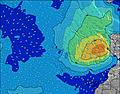 |  |  | 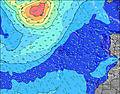 |  |  | 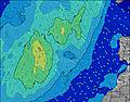 | 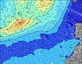 | |||||||||||||||
Wave Height (m) Direction Period (s) | NNE 6 | NNE 6 | NNE 6 | N 8 | N 8 | N 8 | N 8 | N 7 | N 8 | N 8 | N 8 | N 8 | N 8 | N 8 | N 8 | N 8 | N 8 | N 8 | N 8 | N 8 | N 8 | N 8 | N 9 | N 9 |
Wave Graph | ||||||||||||||||||||||||
156 | 169 | 160 | 308 | 308 | 337 | 287 | 279 | 329 | 302 | 280 | 273 | 318 | 323 | 284 | 284 | 291 | 260 | 258 | 304 | 311 | 320 | 404 | 413 | |
Wind (km/h) | ||||||||||||||||||||||||
Wind State on-shore cross-onshore cross-shore cross-offshore off-shore glassy | cross-on | on | on | on | on | cross-on | cross-on | cross-on | cross-on | on | on | cross-on | cross-on | on | on | on | on | on | cross-on | on | on | on | on | on |
High Tide | 1:55AM1.96m | 2:10PM2.14m | 2:32AM1.99m | 2:46PM2.20m | 3:07AM2.01m | 3:21PM2.23m | ||||||||||||||||||
Low Tide | 7:52AM0.45m | 8:23PM0.37m | 8:28AM0.40m | 8:59PM0.34m | 9:02AM0.38m | 9:34PM0.33m | ||||||||||||||||||
— | — | 7:00 | — | — | — | — | — | — | — | 7:00 | — | — | — | — | — | — | — | 7:00 | — | — | — | — | — | |
— | — | — | — | — | — | 8:57 | — | — | — | — | — | — | — | 8:57 | — | — | — | — | — | — | — | 8:57 | — | |
mm | — | — | — | — | — | — | — | — | — | — | — | — | — | — | — | — | — | — | — | — | — | — | — | — |
Temp °C | 19 | 19 | 19 | 20 | 21 | 22 | 22 | 21 | 20 | 19 | 19 | 21 | 22 | 22 | 22 | 20 | 20 | 20 | 20 | 20 | 21 | 21 | 21 | 20 |
Feels °C | 16 | 16 | 16 | 18 | 19 | 20 | 18 | 19 | 22 | 18 | 17 | 20 | 19 | 20 | 21 | 19 | 20 | 19 | 20 | 20 | 21 | 20 | 20 | 19 |
Swell 1 Height (m) Direction Period (s) | NNW 8 | NNW 8 | NNW 8 | NW 8 | NW 13 | NW 13 | NNW 12 | NW 12 | NW 12 | NW 11 | NW 11 | NW 11 | NNW 11 | N 8 | N 8 | N 8 | N 8 | NW 10 | NW 10 | N 8 | N 8 | N 8 | N 9 | N 9 |
68 | 68 | 116 | 16 | 46 | 85 | 103 | 147 | 142 | 185 | 166 | 166 | 200 | 323 | 284 | 284 | 291 | 148 | 145 | 304 | 311 | 320 | 404 | 413 | |
Swell 2 Height (m) Direction Period (s) | WNW 8 | NW 8 | NW 8 | NNW 14 | NW 8 | WNW 8 | WNW 8 | WNW 8 | WNW 8 | NW 8 | NNW 14 | NNW 13 | W 8 | NW 11 | NW 11 | NW 10 | NW 10 | ENE 6 | NNW 13 | NNW 10 | NNW 10 | NNW 10 | WNW 10 | NNW 11 |
28 | 18 | 17 | 20 | 17 | 6 | 6 | 6 | 6 | 3 | 36 | 35 | 1 | 114 | 163 | 160 | 151 | 13 | 57 | 88 | 114 | 39 | 9 | 43 | |
Swell 3 Height (m) Direction Period (s) | — | N 16 | NW 15 | — | — | WNW 8 | — | NW 12 | ENE 9 | NNW 8 | W 8 | N 13 | — | NNW 12 | NNW 13 | NNW 13 | NNW 13 | NNW 13 | N 13 | NNW 13 | NNW 12 | NW 10 | WNW 10 | WNW 9 |
— | 5 | 8 | — | — | 6 | — | 37 | 8 | 23 | 1 | 4 | — | 61 | 17 | 35 | 35 | 35 | 3 | 53 | 29 | 23 | 9 | 8 | |
Wind waves Height (m) Direction Period (s) | NNE 6 | NNE 6 | NNE 6 | N 8 | N 8 | N 8 | N 8 | N 7 | N 8 | N 8 | N 8 | N 8 | N 8 | — | — | — | — | N 8 | N 8 | NE 7 | NE 6 | NNW 3 | NNW 2 | NW 3 |
156 | 169 | 160 | 308 | 308 | 337 | 287 | 279 | 329 | 302 | 280 | 273 | 318 | — | — | — | — | 260 | 258 | 79 | 43 | 2 | 1 | 2 | |
Nearest Offshore or Glassy | ||||||||||||||||||||||||
Distance (km) | 287 | 292 | 292 | 287 | 287 | 286 | 286 | 286 | 12 | 15 | 15 | 15 | 286 | 287 | 15 | 15 | 15 | 15 | 15 | 15 | 15 | 180 | 180 | 180 |
Best forecast wave conditions in Fuerteventura | ||||||||||||||||||||||||
Best forecast wave conditions in Spain (Africa) | ||||||||||||||||||||||||
Header Global | ||||||||||||||||||||||||
- Map Icons:
 Break
Break Live Wave Height (m)
 Live Wind Speed (km/h)
 Surf Rating (10 Max)
 Ocean Swells (m)
- Wind Speed (km/h)


FREE! Surf-Forecast.com widget for your website
The surf report / weather widget below is available to embed on third party websites free of charge and provides a summary of our Mejillones surf forecast. Simply grab the html code snippet that we provide and paste it into your own site. You can choose your preferred language and metric/imperial units for the surf forecast feed to suit users of your site. Click here to get the code.
 Nearest