

Surf Forecasts:

Isla Negra surf forecast from 1 Aug 2026:
- Best quality surf: Sunday 2 Aug, 2PM (local time) - 8ft (2.5m), 11s period, W swell with glassy winds.
- Most powerful swell: Sunday 2 Aug, 5AM (local time) - 8ft (2.5m), 12s period, W swell with 2,001 kJ wave energy.
- Next surfable swell (1★+): Sunday 2 Aug, 2PM (local time) - 8ft (2.5m), 11s period with W swell.
Best Forecast Surf Conditions for Isla Negra this week:
The surf forecast for Isla Negra over the next 16 days: The first swell (rated 1 star or higher) is forecast to arrive on Sunday (Aug 02) at 2PM. The primary swell is predicted to be 2.5m and 11s period. The wind is predicted to be glassy as the swell arrives.
The most powerful waves expected at Isla Negra in the next 16 days are 2.5m 12s and forecast to arrive on Sunday (Aug 02) at 5AM. Winds are predicted to be cross-onshore at the time the swell arrives. The largest open ocean swell (not directed at the beach) is 1.6m 9s period and expected on Saturday (Aug 08) at 8AM.
| Wave Type | Time (-04) & Date | Wave Height & Period |
|---|---|---|
| Next good surf (1 star+) | 2PM (Sun 2nd Aug) | 8ft (2.5m) 11s |
| Best Surf | 2PM (Sun 2nd Aug) | 8ft (2.5m) 11s |
| Most Powerful | 5AM (Sun 2nd Aug) | 8ft (2.5m) 12s |
Table - best surf conditions forecast for Isla Negra over the next 16 days.
The Lowdown
G'day, I'm Rusty, and I've got the lowdown on the local surf scene for the next couple of weeks. We're looking at a bit of a mixed bag, with a defined run of solid swell and clean conditions in the first week, followed by a major lull.
Right now, the water temperature at Isla Negra is sitting at 57°, which is about average for this time of year, nothing to get too excited about.
The first real action kicks off on the morning of Sunday, August 2nd. We've got a solid 8ft swell rolling in from the west, with a period of 11 seconds. The combined energy is strong at 1817, so there's plenty of power in the water. The wind is light from the ENE, creating a cross-shore bump. This is a big swell for the spot, so it's definitely one for the advanced crew only. The consistency is very consistent, and the exposure is to the NNW, which lines up well with the swell direction. Crowds are possible here, so keep that in mind.
The best of the bunch looks like Monday afternoon, August 3rd. The swell drops to a more manageable 7ft, still from the west, with a 12-second period and moderate energy (1155). But the wind goes glassy, coming from the SSW. That's going to make for some absolutely clean, smooth waves. It's excellent surf conditions, but still a bit on the bigger side, so it's for experienced surfers.
Tuesday, August 4th, is also a good shout. The swell is 6ft from the WSW with a 12-second period in the morning, and the wind is offshore from the south at 6 mph. The afternoon sees a similar setup with a cross-offshore breeze. The energy is moderate (944 and 813), and the waves will be clean. Wednesday, August 5th, looks clean again in the morning with 5ft waves from the WSW and a 12-second period, and the afternoon bumps up to 6ft with a longer 14-second period, giving it a bit more punch (1441 energy). The wind is cross-offshore both sessions.
Then we hit a big gap. After Thursday afternoon, August 6th, things drop off dramatically. From Friday, August 7th, through to Wednesday, August 13th, there's basically nothing for the surfboard. The combined energy drops to zero or single digits for most of that period. You'll see a couple of tiny 1ft pulses on August 12th, but it's not worth the paddle.
The next glimmer of hope comes on Saturday, August 15th, with a 3ft swell from the west, but the energy is still low (125) and the conditions are marked as poor. The last day in the window, Sunday, August 16th, has a 2ft swell from the WSW with a very long 15-second period, generating 299 energy. The wind is offshore from the south, so it'll be clean. But the swell is small, so it's a long shot.
Overall, the standout is Monday afternoon, August 3rd, for the glassy conditions and solid 7ft swell. The first week has a few good windows, but after that, it's a genuine flat spell for nearly a week.
Rusty.
Short Range ForecastLight rain (total 6mm), mostly falling on Sat night. Very mild (max 17°C on Mon morning, min 13°C on Sat morning). Wind will be generally light. | Days 4-6 Weather SummaryModerate rain (total 11mm), heaviest on Thu morning. Very mild (max 17°C on Tue afternoon, min 11°C on Thu night). Mainly fresh winds. | ||||||||||||||||||||
Saturday 1 | Sunday 2 | Monday 3 | Tuesday 4 | Wednesday 5 | Thursday 6 | Friday 7 | |||||||||||||||
AM | PM | Night | AM | PM | Night | AM | PM | Night | AM | PM | Night | AM | PM | Night | AM | PM | Night | AM | PM | Night | |
Swell Height Map | 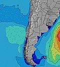 |  |  | 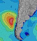 | 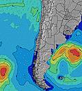 | 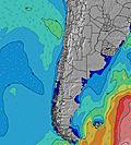 | 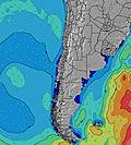 | ||||||||||||||
Wave Height (m) Direction Period (s) | W 9 | W 10 | WNW 10 | W 11 | W 12 | W 12 | W 12 | W 12 | W 12 | WSW 12 | WSW 12 | WSW 12 | WSW 12 | WSW 14 | WSW 14 | WSW 13 | WSW 13 | WSW 12 | NW 11 | W 9 | WSW 11 |
Wave Graph | |||||||||||||||||||||
198 | 181 | 598 | 1796 | 1517 | 1438 | 1155 | 1155 | 1194 | 901 | 807 | 671 | 623 | 1435 | 1159 | 756 | 572 | 417 | 5 | 2 | 12 | |
Wind (km/h) | |||||||||||||||||||||
Wind State on-shore cross-onshore cross-shore cross-offshore off-shore glassy | cross-on | on | cross-on | cross | on | cross-on | cross-on | glassy | off | off | cross-off | off | cross-off | cross-off | cross-on | cross-on | cross-off | cross-off | glassy | cross-on | glassy |
High Tide | 12:00PM1.37m | 00:31AM1.01m | 12:32PM1.29m | 1:06AM1.04m | 1:06PM1.20m | 1:46AM1.07m | 1:44PM1.08m | 2:32AM1.09m | 2:32PM0.96m | 3:29AM1.12m | 3:36PM0.84m | 4:40AM1.16m | 5:06PM0.76m | ||||||||
Low Tide | 6:34PM0.12m | 6:11AM0.24m | 7:02PM0.14m | 6:52AM0.29m | 7:31PM0.18m | 7:41AM0.34m | 8:04PM0.23m | 8:41AM0.40m | 8:45PM0.29m | 10:03AM0.43m | 9:39PM0.34m | 11:43AM0.41m | 10:53PM0.36m | ||||||||
7:37 | — | — | 7:37 | — | — | 7:35 | — | — | 7:35 | — | — | 7:33 | — | — | 7:33 | — | — | 7:31 | — | — | |
— | 6:07 | — | — | 6:07 | — | — | 6:08 | — | — | 6:09 | — | — | 6:09 | — | — | 6:10 | — | — | 6:12 | — | |
mm | — | — | 4 | 2 | — | — | — | — | — | — | — | — | — | — | — | 8 | 3 | — | — | — | — |
Temp °C | 15 | 15 | 14 | 14 | 16 | 15 | 17 | 17 | 15 | 14 | 17 | 15 | 16 | 16 | 15 | 14 | 13 | 12 | 12 | 13 | 12 |
Feels °C | 13 | 12 | 10 | 12 | 16 | 14 | 15 | 15 | 14 | 12 | 16 | 13 | 14 | 14 | 13 | 7 | 11 | 10 | 10 | 10 | 11 |
Swell 1 Height (m) Direction Period (s) | W 9 | SW 12 | WNW 10 | W 11 | W 12 | W 12 | W 12 | W 12 | W 12 | WSW 12 | WSW 12 | WSW 12 | WSW 12 | WSW 14 | WSW 14 | WSW 13 | WSW 13 | WSW 12 | SW 12 | SW 12 | SW 8 |
198 | 367 | 598 | 1796 | 1517 | 1438 | 1155 | 1155 | 1194 | 901 | 807 | 671 | 623 | 1435 | 1159 | 756 | 572 | 417 | 325 | 106 | 284 | |
Swell 2 Height (m) Direction Period (s) | SW 12 | W 10 | SW 12 | SW 11 | SW 10 | — | — | SW 10 | SSW 9 | WSW 20 | SW 19 | SW 18 | WSW 15 | NW 12 | NW 12 | NW 12 | NW 12 | NW 12 | SW 18 | SW 16 | SW 15 |
252 | 181 | 197 | 31 | 27 | — | — | 25 | 8 | 37 | 95 | 154 | 493 | 6 | 5 | 6 | 5 | 5 | 48 | 165 | 258 | |
Swell 3 Height (m) Direction Period (s) | NW 9 | WSW 14 | WSW 13 | WNW 14 | WNW 14 | — | — | — | SW 20 | NW 12 | NW 12 | NW 12 | NW 12 | — | — | — | — | — | NW 11 | W 9 | WSW 11 |
115 | 38 | 151 | 21 | 40 | — | — | — | 16 | 6 | 6 | 6 | 5 | — | — | — | — | — | 5 | 2 | 12 | |
Wind waves Height (m) Direction Period (s) | — | NW 8 | — | — | — | — | — | — | — | — | — | — | — | SW 4 | — | — | — | — | — | SW 8 | — |
— | 98 | — | — | — | — | — | — | — | — | — | — | — | 5 | — | — | — | — | — | 226 | — | |
Nearest Offshore or Glassy | |||||||||||||||||||||
Distance (km) | 1 | 20 | 58 | 1 | 13 | 1 | 1 | 0 | 0 | 0 | 0 | 0 | 0 | 0 | 1 | 189 | 0 | 0 | 1 | 97 | 1 |
Best forecast wave conditions in Santiago | |||||||||||||||||||||
Best forecast wave conditions in Chile | |||||||||||||||||||||
Header Global | |||||||||||||||||||||
- Map Icons:
 Break
Break Live Wave Height (m)
 Live Wind Speed (km/h)
 Surf Rating (10 Max)
 Ocean Swells (m)
- Wind Speed (km/h)
Latest Updates


FREE! Surf-Forecast.com widget for your website
The surf report / weather widget below is available to embed on third party websites free of charge and provides a summary of our Isla Negra surf forecast. Simply grab the html code snippet that we provide and paste it into your own site. You can choose your preferred language and metric/imperial units for the surf forecast feed to suit users of your site. Click here to get the code.
Information about the Isla Negra Surf forecast
The above surf forecast table for Isla Negra provides essential information for determining whether the surfing conditions will be good over the next 16 days. A general guide to surfing at Isla Negra can be found by selecting the local surf guide option on the grey menu. Our Isla Negra surf forecast is unique since it includes wave energy (power) that defines the real feel of the surf rather than just the height or the period. If you surf the same spot (Isla Negra) regularly then make a mental note of the wave energy from the surf forecast table each time you go. Very soon you may start to choose your surf days based on the wave energy alone combined with our forecast of favourable offshore wind conditions. Our star ratings will help here and of course you will also find the usual wave height and period predictions on our surf forecasts as well as a full break down of the swell components under our advanced users option (to reveal that, click the little Einstein character under the tide times).
Further information to help with frequently asked questions about our surf forecast for Isla Negra may be found under the help tab on the top menu and also by moving your mouse over the question marks on the surf forecast table itself. Please always bear in mind that the forecast is for near-shore open water and local factors at each surf break influence the actual breaking wave height, such as the beach / reef profile, water depths offshore and shelter.
Isla Negra is 19 km (12 miles) from the city of San Antonio. If you plan a holiday in Santiago, look for hotels and other accommodation in San Antonio. San Antonio has rooms for a wide range of budgets as well as car hire and transport links.
 Nearest