

Surf Forecasts:

El Emir surf forecast from 6 Jul 2026:
- Best quality surf: Saturday 11 Jul, 6AM (local time) - 3ft (0.9m), 10s period, ESE swell with glassy winds.
- Most powerful swell: Tuesday 7 Jul, 12PM (local time) - 4.5ft (1.3m), 10s period, SSW swell with 349 kJ wave energy.
- Next surfable swell (1★+): Thursday 9 Jul, 3AM (local time) - 1.5ft (0.4m), 10s period with ESE swell.
Best Forecast Surf Conditions for El Emir this week:
The surf forecast for El Emir over the next 16 days: The first swell (rated 1 star or higher) is forecast to arrive on Thursday (Jul 09) at 3AM. The primary swell is predicted to be 0.4m and 10s period with a secondary swell of 0.2m and 6s. The wind is predicted to be cross-offshore as the swell arrives.
The most powerful waves expected at El Emir in the next 16 days are 1.3m 10s and forecast to arrive on Tuesday (Jul 07) at 12PM. Winds are predicted to be cross-offshore at the time the swell arrives. The largest open ocean swell (not directed at the beach) is 1.3m 5s period and expected on Monday (Jul 06) at 9PM.
| Wave Type | Time (-03) & Date | Wave Height & Period |
|---|---|---|
| Next good surf (1 star+) | 3AM (Thu 9th Jul) | 1.5ft (0.4m) 10s |
| Best Surf | 6AM (Sat 11th Jul) | 3ft (0.9m) 10s |
| Most Powerful | 12PM (Tue 7th Jul) | 4.5ft (1.3m) 10s |
Table - best surf conditions forecast for El Emir over the next 16 days.
Updates in hr min s Forecast update imminent
Righto folks, Rusty here. Let’s have a look at what El Emir’s got cookin’ for the next couple of weeks. It’s a beach and reef setup, exposed to the swell, with a crowd factor that can get busy at times. The water temp’s sittin’ right on 52°, which is about average for this time of year, so nothin’ wild to report there.
Alright, it’s gonna be a bit of a slow burner to start. Monday the 6th and Tuesday the 7th are a write-off with gusty cross-shore winds and poor conditions, not worth paddlin’ out. Wednesday the 8th is flat and clean but tiny. Thursday the 9th morning shows a glimmer with 2ft from the ESE at 10 seconds and light offshore NW wind at 3 mph, keepin’ it clean, but the energy’s weak (65) and it’s only just surfable. Friday the 10th morning is glassy (0 wind) with a tiny 2ft ESE swell, period 10 seconds, energy still weak (88) – again, nothin’ to get excited about.
Now, here’s the first real standout. Saturday the 11th morning – that’s where we get somethin’ decent. The swell bumps to 3ft from the ESE, period 10 seconds, and the energy jumps right up to a solid 359 (moderate). The wind is glassy at 0 mph early, so it’ll be clean as a whistle. For a beginner-friendly break, this is the pick of the first week – small, clean, and easy. Just keep an eye on the crowds, they can be around.
After that, we hit a bit of a lull. Sunday the 12th through to Tuesday the 14th is mostly poor with cross-onshore winds and messy, choppy conditions. Not your friend.
Wednesday the 15th afternoon starts to rumble with 8ft from the SW at a short 7 seconds and energy cranked up to 544 (moderate). The wind’s cross-off at 12 mph, so it stays clean, but the period is short and dumpy – this is expert territory at over 8ft, and even then, it’s only marginal. Might be one for the kite crew, honestly.
A better bet for advanced surfers comes Thursday the 16th morning: 6ft from the SW, 7 seconds, energy 400 (moderate), with light offshore NW wind at 6 mph. Clean and punchy.
Then look out for Friday the 17th morning – that’s a hidden gem. 4ft from the S, 11 seconds, giving it shape, with a glassy 3 mph S wind. Energy’s a solid 359 (moderate). Clean, glassy, and a decent size for a ripper session.
The real standout of the whole outlook, though, is Monday the 20th morning. That’s a week and a half out, so keep the fingers crossed. We’ve got 5ft from the SE at a very long 14 seconds, and the energy smashes 865 (strong). The wind is offshore from the NNW at 12 mph, keepin’ it clean. That’s groundswell, proper push, and with the reef at El Emir, the direction’s a good match. It’s gonna be a beauty for anyone with a bit of know-how – the long period might make it a bit straight on the beach section, but the reef should handle it nicely.
After that, Tuesday the 21st turns poor again with cross-onshore wind and chop. So, bottom line: if you want a fun, easy paddle, Saturday the 11th morning is your best bet. For the experienced crew, lock in Monday the 20th morning – that’s the one to wait for.
Rusty.
Short Range ForecastSome drizzle, heaviest during Mon morning. Very mild (max 16°C on Wed afternoon, min 7°C on Mon afternoon). Winds decreasing (strong winds from the W on Mon night, light winds from the NW by Wed night). | Days 4-6 Weather SummaryLight rain (total 3mm), mostly falling on Fri night. Very mild (max 16°C on Thu afternoon, min 11°C on Thu night). Wind will be generally light. | ||||||||||||||||||||
Monday 6 | Tuesday 7 | Wednesday 8 | Thursday 9 | Friday 10 | Saturday 11 | Sunday 12 | |||||||||||||||
AM | PM | Night | AM | PM | Night | AM | PM | Night | AM | PM | Night | AM | PM | Night | AM | PM | Night | AM | PM | Night | |
Swell Height Map |  |  | 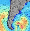 | 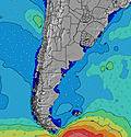 | 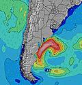 | 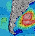 | 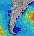 | ||||||||||||||
Wave Height (m) Direction Period (s) | ESE 10 | SW 6 | S 7 | SSW 9 | S 10 | S 8 | S 7 | ESE 10 | ESE 10 | ESE 10 | ESE 11 | ESE 10 | ESE 10 | ESE 11 | SSE 7 | ESE 10 | ESE 14 | ESE 13 | ESE 13 | ESE 13 | ESE 13 |
Wave Graph | |||||||||||||||||||||
71 | 159 | 45 | 321 | 268 | 63 | 25 | 18 | 22 | 62 | 66 | 59 | 80 | 88 | 80 | 198 | 115 | 156 | 147 | 106 | 109 | |
Wind (km/h) | |||||||||||||||||||||
Wind State on-shore cross-onshore cross-shore cross-offshore off-shore glassy | cross | cross-off | cross-off | cross-off | cross-off | cross-off | cross-off | cross-off | off | off | cross | cross | glassy | on | cross | glassy | cross-on | on | cross-on | cross-on | cross-on |
High Tide | 11:50AM0.25m | 5:06PM0.17m | 00:24AM0.25m | 5:44AM0.20m | 12:34PM0.28m | 1:23AM0.24m | 6:44AM0.21m | 1:24PM0.31m | 2:29AM0.22m | 7:55AM0.20m | 2:21PM0.34m | 3:38AM0.21m | 3:22PM0.38m | 4:41AM0.20m | 4:26PM0.41m | 5:36AM0.20m | 5:28PM0.43m | ||||
Low Tide | 3:33PM0.17m | 8:21PM0.12m | 3:40AM0.19m | 9:08PM0.09m | 4:25AM0.19m | 9:59PM0.06m | 5:21AM0.18m | 10:54PM0.03m | 6:29AM0.18m | 11:55PM0.01m | 7:40AM0.16m | 00:58AM0.00m | 8:46AM0.14m | 2:01AM-0.00m | |||||||
7:47 | — | — | 7:47 | — | — | 7:47 | — | — | 7:47 | — | — | 7:47 | — | — | 7:46 | — | — | 7:46 | — | — | |
— | 5:40 | — | — | 5:40 | — | — | 5:42 | — | — | 5:42 | — | — | 5:43 | — | — | 5:43 | — | — | 5:44 | — | |
mm | 1 | — | — | — | — | — | — | — | — | — | — | — | — | — | 3 | — | — | — | 4 | — | — |
Temp °C | 8 | 8 | 9 | 9 | 13 | 11 | 12 | 16 | 15 | 13 | 16 | 12 | 12 | 12 | 12 | 12 | 12 | 11 | 11 | 10 | 10 |
Feels °C | -1 | -1 | 0 | 0 | 8 | 5 | 6 | 11 | 10 | 9 | 12 | 10 | 11 | 9 | 8 | 11 | 10 | 6 | 7 | 4 | 3 |
Swell 1 Height (m) Direction Period (s) | ESE 10 | ESE 9 | S 7 | SSW 9 | S 10 | S 8 | S 7 | S 7 | ESE 10 | ESE 10 | ESE 11 | ESE 10 | ESE 10 | ESE 11 | SSE 7 | ESE 10 | S 11 | ESE 6 | ESE 13 | SSE 9 | SSE 8 |
71 | 68 | 45 | 321 | 268 | 63 | 25 | 14 | 22 | 62 | 66 | 59 | 80 | 88 | 75 | 198 | 63 | 41 | 147 | 99 | 82 | |
Swell 2 Height (m) Direction Period (s) | S 14 | S 13 | E 9 | ESE 9 | ESE 9 | ESE 10 | ESE 9 | ESE 10 | S 6 | S 6 | S 6 | — | S 17 | S 9 | ESE 10 | S 7 | ESE 14 | ESE 13 | ESE 6 | ESE 13 | ESE 13 |
16 | 13 | 42 | 28 | 17 | 18 | 17 | 18 | 3 | 3 | 1 | — | 6 | 2 | 80 | 23 | 115 | 156 | 11 | 106 | 109 | |
Swell 3 Height (m) Direction Period (s) | S 8 | — | S 12 | — | S 18 | S 16 | S 15 | S 14 | SE 7 | — | — | — | S 10 | S 15 | S 14 | SE 15 | E 11 | SSE 10 | S 15 | ESE 6 | SSE 10 |
1 | — | 3 | — | 7 | 5 | 4 | 4 | 2 | — | — | — | 2 | 4 | 4 | 57 | 57 | 75 | 4 | 6 | 11 | |
Wind waves Height (m) Direction Period (s) | SW 5 | SW 6 | WSW 5 | W 5 | W 5 | WNW 4 | WNW 4 | W 4 | WNW 4 | WNW 3 | WNW 3 | — | — | S 5 | — | ESE 7 | ESE 6 | — | SSE 9 | — | — |
65 | 159 | 102 | 59 | 44 | 28 | 22 | 14 | 3 | 1 | 2 | — | — | 12 | — | 81 | 64 | — | 82 | — | — | |
Nearest Offshore or Glassy | |||||||||||||||||||||
Distance (km) | 127 | 127 | 39 | 39 | 80 | 34 | 34 | 81 | 9 | 0 | 1 | 1 | 0 | 523 | 6 | 0 | 127 | 19 | 85 | 523 | 237 |
Best forecast wave conditions in Uruguay - South | |||||||||||||||||||||
Best forecast wave conditions in Uruguay | |||||||||||||||||||||
Header Global | |||||||||||||||||||||
- Map Icons:
 Break
Break Live Wave Height (m)
 Live Wind Speed (km/h)
 Surf Rating (10 Max)
 Ocean Swells (m)
- Wind Speed (km/h)


FREE! Surf-Forecast.com widget for your website
The surf report / weather widget below is available to embed on third party websites free of charge and provides a summary of our El Emir surf forecast. Simply grab the html code snippet that we provide and paste it into your own site. You can choose your preferred language and metric/imperial units for the surf forecast feed to suit users of your site. Click here to get the code.
Information about the El Emir Surf forecast
The above surf forecast table for El Emir provides essential information for determining whether the surfing conditions will be good over the next 16 days. A general guide to surfing at El Emir can be found by selecting the local surf guide option on the grey menu. Our El Emir surf forecast is unique since it includes wave energy (power) that defines the real feel of the surf rather than just the height or the period. If you surf the same spot (El Emir) regularly then make a mental note of the wave energy from the surf forecast table each time you go. Very soon you may start to choose your surf days based on the wave energy alone combined with our forecast of favourable offshore wind conditions. Our star ratings will help here and of course you will also find the usual wave height and period predictions on our surf forecasts as well as a full break down of the swell components under our advanced users option (to reveal that, click the little Einstein character under the tide times).
Further information to help with frequently asked questions about our surf forecast for El Emir may be found under the help tab on the top menu and also by moving your mouse over the question marks on the surf forecast table itself. Please always bear in mind that the forecast is for near-shore open water and local factors at each surf break influence the actual breaking wave height, such as the beach / reef profile, water depths offshore and shelter.
Are you planning a holiday in Uruguay - South? If you are looking for accommodation near El Emir, camping, hotels and holiday cottages in Uruguay - South, consider staying in Maldonado which is 7 km (4 miles) away. Other places in and around Uruguay - South where you can find information about places to rent, and car hire include San Carlos which is 18 km (11 miles) away, Minas, Rocha and La Paloma.
 Nearest