

Surf Forecasts:

La Olla surf forecast from 14 Jul 2026:
- Best quality surf: Tuesday 14 Jul, 3AM (local time) - 3ft (0.9m), 10s period, ESE swell with cross-offshore winds.
- Most powerful swell: Tuesday 21 Jul, 12AM (local time) - 4.5ft (1.3m), 11s period, SSE swell with 389 kJ wave energy.
- Next surfable swell (1★+): Tuesday 14 Jul, 3AM (local time) - 3ft (0.9m), 10s period with ESE swell.
Best Forecast Surf Conditions for La Olla this week:
The surf forecast for La Olla over the next 16 days: The first swell (rated 1 star or higher) is forecast to arrive on Tuesday (Jul 14) at 3AM. The primary swell is predicted to be 0.9m and 10s period with a secondary swell of 0.2m and 9s. The wind is predicted to be cross-offshore as the swell arrives.
The most powerful waves expected at La Olla in the next 16 days are 1.3m 11s and forecast to arrive on Tuesday (Jul 21) at 12AM. Winds are predicted to be cross-offshore at the time the swell arrives. The largest open ocean swell (not directed at the beach) is 0.4m 3s period and expected on Tuesday (Jul 14) at 9AM.
| Wave Type | Time (-03) & Date | Wave Height & Period |
|---|---|---|
| Next good surf (1 star+) | 3AM (Tue 14th Jul) | 3ft (0.9m) 10s |
| Best Surf | 3AM (Tue 14th Jul) | 3ft (0.9m) 10s |
| Most Powerful | 12AM (Tue 21st Jul) | 4.5ft (1.3m) 11s |
Table - best surf conditions forecast for La Olla over the next 16 days.
The Lowdown
Alright, folks, Rusty here. Let’s have a look at what’s coming down the pipe for the next couple of weeks.
Honestly, it’s a pretty flat and quiet stretch ahead. The only spot that’s even worth talking about is La Olla, but even that’s a tough sell for most of the run. The water temp is sitting about average for this time of year, so no surprises there.
The best we’ve got is a tiny window early on, Tuesday the 14th. There’s a small pulse of swell coming in from the ESE, hanging around 3ft with a 10-second period. The combined energy is moderate (149), so there’s a little bit of push, but it’s nothing to write home about. The wind is a clean cross-offshore from the north at 9 mph, keeping the surface clean. It’s a beginner-friendly point break, and it’s fairly consistent, but you’ll be sharing it with others – crowds are often a thing here. The swell direction is coming from the ESE, which is not the optimum SE direction, but it’s close enough to get a few fun ones. It’s the standout by default, because after Tuesday morning, it all goes downhill.
From Wednesday the 15th right through to Saturday the 25th, it’s a long, lean stretch. The swell drops to 2ft or lower, with periods barely reaching 8 seconds, and the energy drops into the weak range (usually under 100). Winds are often cross or cross-on, with some onshore and even strong offshore winds that just make things difficult to paddle into. There are days where the waves are clean but simply too small. It’s a solid 10-day gap where there’s nothing really worth paddling out for.
There’s a tiny flicker of hope on the 26th and 27th (Sunday and Monday), where the swell bumps up to 4ft, but the energy is still moderate (287-339), and the conditions are only described as marginal. The winds are mostly cross-off or cross, so it might be clean, but the forecast is uncertain. That’s a long way out, so don’t hold your breath.
Overall, this is a poor outlook. The inconsistency is normal for this stretch, but it’s a real dry spell. Unless you’re desperate for a small, clean wave on Tuesday the 14th, I’d say leave the board in the car.
Rusty.
Short Range ForecastLight rain (total 8mm), mostly falling on Thu afternoon. Very mild (max 19°C on Wed afternoon, min 9°C on Tue morning). Wind will be generally light. | Days 5-7 Weather SummaryModerate rain (total 16mm), heaviest on Sat night. Warm (max 22°C on Fri afternoon, min 10°C on Sun morning). Wind will be generally light. | ||||||||||||||||||||
Tuesday 14 | Wednesday 15 | Thursday 16 | Friday 17 | Saturday 18 | Sunday 19 | Mon 20 | |||||||||||||||
Night | AM | PM | Night | AM | PM | Night | AM | PM | Night | AM | PM | Night | AM | PM | Night | AM | PM | Night | AM | PM | |
Swell Height Map |  | 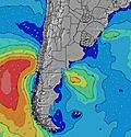 | 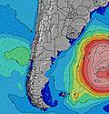 | 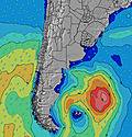 | 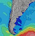 | 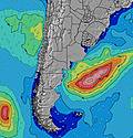 | 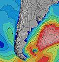 | 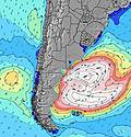 | |||||||||||||
Wave Height (m) Direction Period (s) | SE 11 | ESE 10 | ESE 9 | ESE 8 | E 8 | E 8 | E 8 | E 8 | E 8 | ENE 10 | E 10 | E 7 | E 8 | E 10 | E 10 | ESE 10 | E 11 | E 10 | S 7 | SSE 8 | SSE 9 |
Wave Graph | |||||||||||||||||||||
163 | 148 | 90 | 75 | 45 | 45 | 46 | 45 | 46 | 128 | 31 | 37 | 43 | 65 | 47 | 112 | 20 | 19 | 177 | 211 | 261 | |
Wind (km/h) | |||||||||||||||||||||
Wind State on-shore cross-onshore cross-shore cross-offshore off-shore glassy | cross | cross-off | cross-off | cross | cross | cross | cross-on | cross | cross | cross | cross | cross-off | cross-off | cross-off | cross-on | on | cross | cross-on | on | on | cross-on |
High Tide | 7:16AM0.22m | 1:35PM0.15m | 7:27PM0.44m | 8:04AM0.24m | 1:44PM0.14m | 8:23PM0.42m | 8:52AM0.26m | 2:03PM0.14m | 9:18PM0.38m | 9:41AM0.28m | 2:16PM0.15m | 10:13PM0.34m | 10:31AM0.30m | 11:08PM0.30m | 11:23AM0.31m | 00:04AM0.26m | 4:13AM0.22m | 12:16PM0.31m | |||
Low Tide | 3:01AM0.00m | 2:12PM0.15m | 3:57AM0.02m | 3:38PM0.12m | 4:50AM0.04m | 12:37PM0.13m | 5:40AM0.06m | 1:43PM0.15m | 6:28AM0.08m | 6:46PM0.05m | 7:15AM0.10m | 7:42PM0.04m | 3:08AM0.21m | ||||||||
— | 7:45 | — | — | 7:45 | — | — | 7:43 | — | — | 7:43 | — | — | 7:43 | — | — | 7:43 | — | — | 7:41 | — | |
— | — | 5:45 | — | — | 5:45 | — | — | 5:45 | — | — | 5:46 | — | — | 5:47 | — | — | 5:47 | — | — | 5:49 | |
mm | — | — | — | — | — | — | — | 3 | 5 | — | 3 | 3 | 3 | 2 | 1 | 4 | — | — | — | — | — |
Temp °C | 12 | 13 | 16 | 14 | 15 | 19 | 18 | 17 | 17 | 17 | 19 | 22 | 22 | 13 | 12 | 12 | 10 | 11 | 13 | 13 | 14 |
Feels °C | 8 | 9 | 12 | 11 | 12 | 15 | 18 | 15 | 15 | 15 | 17 | 21 | 20 | 12 | 10 | 12 | 6 | 10 | 9 | 10 | 11 |
Swell 1 Height (m) Direction Period (s) | SE 11 | ESE 10 | ESE 9 | ESE 8 | E 8 | E 8 | E 8 | ESE 11 | E 8 | E 10 | E 5 | E 7 | E 8 | E 10 | E 10 | SSW 4 | S 5 | E 10 | E 12 | E 12 | E 10 |
163 | 148 | 90 | 75 | 45 | 45 | 46 | 12 | 46 | 71 | 14 | 37 | 43 | 65 | 47 | 3 | 10 | 19 | 24 | 24 | 8 | |
Swell 2 Height (m) Direction Period (s) | S 9 | S 8 | S 8 | S 8 | ESE 10 | SE 10 | E 12 | S 12 | ESE 11 | S 10 | E 10 | ESE 10 | S 8 | S 7 | SSW 3 | S 12 | ESE 4 | E 4 | — | SE 14 | ENE 10 |
7 | 1 | 1 | 1 | 10 | 4 | 3 | 3 | 22 | 7 | 31 | 20 | 5 | 1 | 1 | 3 | 5 | 4 | — | 7 | 34 | |
Swell 3 Height (m) Direction Period (s) | S 5 | — | — | — | — | — | — | — | S 9 | S 16 | S 9 | S 8 | S 16 | S 14 | S 7 | S 7 | E 11 | S 11 | — | — | — |
2 | — | — | — | — | — | — | — | 2 | 5 | 6 | 5 | 5 | 4 | 1 | 1 | 20 | 2 | — | — | — | |
Wind waves Height (m) Direction Period (s) | NNE 2 | NNW 3 | — | — | — | — | ENE 5 | E 8 | — | ENE 10 | NNE 3 | NNW 3 | NW 3 | WSW 3 | ESE 3 | ESE 10 | E 4 | S 5 | S 7 | SSE 8 | SSE 9 |
1 | 3 | — | — | — | — | 14 | 45 | — | 128 | 2 | 1 | 3 | 1 | 1 | 112 | 9 | 11 | 177 | 211 | 261 | |
Nearest Offshore or Glassy | |||||||||||||||||||||
Distance (km) | 1 | 0 | 0 | 9 | 1 | 7 | 16 | 1 | 77 | 273 | 7 | 1 | 1 | 0 | 78 | 72 | 78 | 72 | 6 | 159 | 53 |
Best forecast wave conditions in Uruguay - South | |||||||||||||||||||||
Best forecast wave conditions in Uruguay | |||||||||||||||||||||
Header Global | |||||||||||||||||||||
- Map Icons:
 Break
Break Live Wave Height (m)
 Live Wind Speed (km/h)
 Surf Rating (10 Max)
 Ocean Swells (m)
- Wind Speed (km/h)


FREE! Surf-Forecast.com widget for your website
The surf report / weather widget below is available to embed on third party websites free of charge and provides a summary of our La Olla surf forecast. Simply grab the html code snippet that we provide and paste it into your own site. You can choose your preferred language and metric/imperial units for the surf forecast feed to suit users of your site. Click here to get the code.
Information about the La Olla Surf forecast
The above surf forecast table for La Olla provides essential information for determining whether the surfing conditions will be good over the next 16 days. A general guide to surfing at La Olla can be found by selecting the local surf guide option on the grey menu. Our La Olla surf forecast is unique since it includes wave energy (power) that defines the real feel of the surf rather than just the height or the period. If you surf the same spot (La Olla) regularly then make a mental note of the wave energy from the surf forecast table each time you go. Very soon you may start to choose your surf days based on the wave energy alone combined with our forecast of favourable offshore wind conditions. Our star ratings will help here and of course you will also find the usual wave height and period predictions on our surf forecasts as well as a full break down of the swell components under our advanced users option (to reveal that, click the little Einstein character under the tide times).
Further information to help with frequently asked questions about our surf forecast for La Olla may be found under the help tab on the top menu and also by moving your mouse over the question marks on the surf forecast table itself. Please always bear in mind that the forecast is for near-shore open water and local factors at each surf break influence the actual breaking wave height, such as the beach / reef profile, water depths offshore and shelter.
Are you planning a holiday in Uruguay - South? If you are looking for accommodation near La Olla, camping, hotels and holiday cottages in Uruguay - South, consider staying in Maldonado which is 6 km (4 miles) away. Other places in and around Uruguay - South where you can find information about places to rent, and car hire include San Carlos which is 17 km (11 miles) away, Minas, Rocha and La Paloma.
 Nearest