

Surf Forecasts:

How big are the waves at Condos today (20 Jun):
- Morning surf: Morning surf (20 Jun, local time) - 3.5ft (1.0m), 8s period with ESE swell.
- Afternoon surf: Afternoon surf (20 Jun, local time) - 4ft (1.2m), 7s period with SE swell.
- Evening surf: Evening surf (20 Jun, local time) - 4ft (1.2m), 7s period with SE swell.
The current surf forecast for Condos at 9AM is: 1.0m 8s primary swell from a East-southeast direction and 0.7m 7s secondary swell from a South-southeast direction (forecast issued at 12:00am June 20). The wind direction is predicted to be cross-onshore.
| Time (CDT) & Date | Wave Height | Wave Period |
|---|---|---|
| Morning (20 Jun) | 3.5ft (1.0m) | 8s |
| Afternoon (20 Jun) | 4ft (1.2m) | 7s |
| Evening (20 Jun) | 4ft (1.2m) | 7s |
Table - waves today at Condos. (Swell directed towards the surf break)
Updates in hr min s Forecast update imminent
Short Range ForecastLight rain (total 9mm), mostly falling on Fri night. Warm (max 29°C on Fri night, min 28°C on Fri night). Mainly fresh winds. | ||||||||||||||||||||||||
Saturday 20 | Sunday 21 | Monday 22 | ||||||||||||||||||||||
1 AM | 4 AM | 7 AM | 10 AM | 1 PM | 4 PM | 7 PM | 10 PM | 1 AM | 4 AM | 7 AM | 10 AM | 1 PM | 4 PM | 7 PM | 10 PM | 1 AM | 4 AM | 7 AM | 10 AM | 1 PM | 4 PM | 7 PM | 10 PM | |
Swell Height Map | 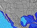 | 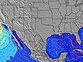 | 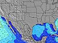 | 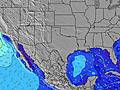 | 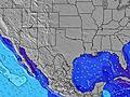 | 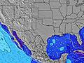 | 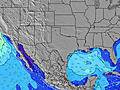 | 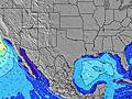 | 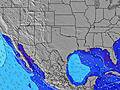 | |||||||||||||||
Wave Height (m) Direction Period (s) | SE 7 | ESE 8 | ESE 8 | ESE 8 | SE 7 | SE 8 | SE 7 | SE 7 | SE 7 | SE 7 | SE 6 | SE 6 | SE 7 | SE 7 | SE 7 | SE 7 | SE 7 | SSE 7 | SSE 7 | SSE 7 | SSE 7 | SE 7 | SE 7 | SE 7 |
Wave Graph | ||||||||||||||||||||||||
215 | 205 | 117 | 120 | 152 | 200 | 156 | 136 | 115 | 139 | 142 | 181 | 192 | 198 | 183 | 183 | 198 | 199 | 244 | 244 | 251 | 233 | 210 | 183 | |
Wind (km/h) | ||||||||||||||||||||||||
Wind State on-shore cross-onshore cross-shore cross-offshore off-shore glassy | cross-on | cross-on | cross-on | cross-on | cross-on | cross-on | on | on | cross-on | cross-on | cross-on | cross-on | cross-on | cross-on | cross-on | cross-on | cross-on | cross-on | cross-on | cross-on | cross-on | cross-on | cross-on | cross-on |
High Tide | 3:43PM-0.00m | 1:29PM-0.00m | 12:19PM0.01m | |||||||||||||||||||||
Low Tide | 6:32AM-0.05m | 6:14AM-0.03m | 9:32PM-0.04m | 9:54PM-0.06m | ||||||||||||||||||||
— | 6:33 | — | — | — | — | — | — | — | 6:33 | — | — | — | — | — | — | — | 6:33 | — | — | — | — | — | — | |
— | — | — | — | — | — | 8:27 | — | — | — | — | — | — | — | 8:27 | — | — | — | — | — | — | — | 8:27 | — | |
mm | 1 | 3 | 2 | 1 | — | — | — | — | 1 | 1 | — | — | — | — | — | — | — | — | — | — | — | — | — | — |
Temp °C | 29 | 28 | 28 | 28 | 28 | 29 | 29 | 29 | 28 | 28 | 28 | 28 | 28 | 28 | 28 | 28 | 28 | 28 | 28 | 28 | 28 | 28 | 28 | 28 |
Feels °C | 31 | 30 | 31 | 31 | 30 | 31 | 31 | 31 | 30 | 30 | 29 | 28 | 28 | 28 | 29 | 29 | 29 | 28 | 28 | 28 | 28 | 28 | 29 | 28 |
Swell 1 Height (m) Direction Period (s) | — | ESE 8 | ESE 8 | ESE 8 | SE 7 | SE 8 | SE 7 | — | — | — | — | — | — | — | — | — | — | — | — | — | — | — | — | — |
— | 173 | 117 | 120 | 152 | 200 | 156 | — | — | — | — | — | — | — | — | — | — | — | — | — | — | — | — | — | |
Swell 2 Height (m) Direction Period (s) | — | — | — | — | — | — | — | — | — | — | — | — | — | — | — | — | — | — | — | — | — | — | — | — |
— | — | — | — | — | — | — | — | — | — | — | — | — | — | — | — | — | — | — | — | — | — | — | — | |
Swell 3 Height (m) Direction Period (s) | — | — | — | — | — | — | — | — | — | — | — | — | — | — | — | — | — | — | — | — | — | — | — | — |
— | — | — | — | — | — | — | — | — | — | — | — | — | — | — | — | — | — | — | — | — | — | — | — | |
Wind waves Height (m) Direction Period (s) | SE 7 | SE 7 | S 7 | SSE 7 | S 7 | — | — | SE 7 | SE 7 | SE 7 | SE 6 | SE 6 | SE 7 | SE 7 | SE 7 | SE 7 | SE 7 | SSE 7 | SSE 7 | SSE 7 | SSE 7 | SE 7 | SE 7 | SE 7 |
215 | 205 | 44 | 48 | 45 | — | — | 136 | 115 | 139 | 142 | 181 | 192 | 198 | 183 | 183 | 198 | 199 | 244 | 244 | 251 | 233 | 210 | 183 | |
Nearest Offshore or Glassy | ||||||||||||||||||||||||
Distance (km) | 1038 | 1038 | 1038 | 1022 | 928 | 959 | 959 | 1070 | 1038 | 1038 | 1038 | 1038 | 1135 | 1135 | 1079 | 1070 | 1038 | 1038 | 1038 | 1038 | 1132 | 1141 | 1065 | 1060 |
Best forecast wave conditions in Texas | ||||||||||||||||||||||||
Best forecast wave conditions in United States | ||||||||||||||||||||||||
Header Global | ||||||||||||||||||||||||
- Map Icons:
 Break
Break Live Wave Height (m)
 Live Wind Speed (km/h)
 Surf Rating (10 Max)
 Ocean Swells (m)
- Wind Speed (km/h)


FREE! Surf-Forecast.com widget for your website
The surf report / weather widget below is available to embed on third party websites free of charge and provides a summary of our Condos surf forecast. Simply grab the html code snippet that we provide and paste it into your own site. You can choose your preferred language and metric/imperial units for the surf forecast feed to suit users of your site. Click here to get the code.
 Nearest