

Surf Forecasts:

Chapmans Point surf forecast from 24 Jul 2026:
- Best quality surf: Friday 31 Jul, 8PM (local time) - 7ft (2.2m), 20s period, SSW swell with offshore winds.
- Most powerful swell: Friday 31 Jul, 11PM (local time) - 11ft (3.5m), 19s period, SSW swell with 9,171 kJ wave energy.
- Next surfable swell (1★+): Saturday 25 Jul, 8AM (local time) - 4.5ft (1.4m), 12s period with SSW swell.
Best Forecast Surf Conditions for Chapmans Point this week:
The surf forecast for Chapmans Point over the next 16 days: The first swell (rated 1 star or higher) is forecast to arrive on Saturday (Jul 25) at 8AM. The primary swell is predicted to be 1.4m and 12s period with a secondary swell of 0.1m and 20s. The wind is predicted to be offshore as the swell arrives.
The most powerful waves expected at Chapmans Point in the next 16 days are 3.5m 19s and forecast to arrive on Friday (Jul 31) at 11PM. Winds are predicted to be cross-offshore at the time the swell arrives. The largest open ocean swell (not directed at the beach) is 1.9m 6s period and expected on Sunday (Jul 26) at 11AM.
| Wave Type | Time (AWST) & Date | Wave Height & Period |
|---|---|---|
| Next good surf (1 star+) | 8AM (Sat 25th Jul) | 4.5ft (1.4m) 12s |
| Best Surf | 8PM (Fri 31st Jul) | 7ft (2.2m) 20s |
| Most Powerful | 11PM (Fri 31st Jul) | 11ft (3.5m) 19s |
Table - best surf conditions forecast for Chapmans Point over the next 16 days.
The Lowdown
Alright, Rusty here. Let’s break it down for Chapmans Point.
Water temp is right around average for this time of year.
Saturday, July 25th kicks it off: clean morning with 1.4m SSW swell at 12 seconds, light offshore NW wind. Energy's moderate (612). Afternoon picks up to 1.5m SSW, still offshore, clean. Nice start.
Sunday, July 26th is a washout. Morning’s choppy with strong WNW wind and 1.0m swell. Afternoon gets wild: 3.5m SW swell and a near gale cross-shore. Big numbers (3229) but a total mess. Monday and Tuesday stay big—around 3.0m SSW—but onshore or light onshore winds ruin the surface. Kite crew might have a look.
Wednesday, July 29th morning is a solid call: 2.4m SSW groundswell at 13 seconds, clean offshore NNE wind. That’s some long-period juice (2747 energy) on a point. For experienced surfers only. Afternoon turns choppy, so get it early.
Thursday, July 30th is a gem. Morning: 1.6m SSW, 15 seconds, clean offshore. Afternoon turns glassy—dead calm, 1.7m SSW, 15 seconds. That’s smooth, clean, and well-shaped. Best of the first week.
Friday, July 31st afternoon: 2.5m SSW at 16 seconds, light NW wind, clean. Big lines (5136). Expert stuff.
Saturday, August 1st onshore and rainy. No good. Sunday, August 2nd drops to 1.6m but cross-shore chop. Not great.
Monday, August 3rd through Wednesday, August 5th is marginal: 1.4m to 2.0m SSW, but winds are fresh or cross-shore. Not worth the effort.
Thursday, August 6th morning: 1.7m SSW, 16 seconds, clean cross-off. Could be a quick session if you’re keen.
Friday, August 7th and Saturday, August 8th are blown out with onshore gales. Nothing doing.
Sunday, August 9th is the grand finale: morning hits with 4.0m SSW, 17-second period groundswell—huge energy (7913). Light cross-off, clean and powerful. Experts only. Afternoon glass-off: 3.5m SSW, 16 seconds, glassy. A proper big-wave day.
Top picks: Thursday July 30th afternoon for clean, glassy fun, and Sunday August 9th morning for serious size and power.
Crowds can show up since the spot’s consistent, but on these standout days, it’s worth a few mates in the lineup.
Rusty.
Short Range ForecastLight rain (total 5mm), mostly falling on Sun night. Very mild (max 16°C on Sat afternoon, min 11°C on Sat morning). Winds increasing (light winds from the NNE on Sat afternoon, strong winds from the WSW by Sun night). | Days 4-6 Weather SummaryMostly dry. Very mild (max 17°C on Thu afternoon, min 11°C on Wed night). Wind will be generally light. | ||||||||||||||||||||
Saturday 25 | Sunday 26 | Monday 27 | Tuesday 28 | Wednesday 29 | Thursday 30 | Friday 31 | |||||||||||||||
AM | PM | Night | AM | PM | Night | AM | PM | Night | AM | PM | Night | AM | PM | Night | AM | PM | Night | AM | PM | Night | |
Swell Height Map |  |  |  |  | 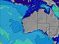 | 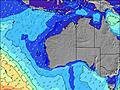 | 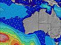 | ||||||||||||||
Wave Height (m) Direction Period (s) | SSW 12 | SSW 12 | SSW 11 | SSW 16 | SW 11 | SW 14 | SSW 14 | SSW 13 | SSW 14 | SSW 15 | SSW 14 | SSW 14 | SSW 13 | SSW 13 | SSW 15 | SSW 15 | SSW 15 | SSW 19 | SSW 17 | SSW 16 | SSW 18 |
Wave Graph | |||||||||||||||||||||
579 | 616 | 341 | 499 | 3229 | 7121 | 3940 | 2754 | 2989 | 3933 | 3035 | 2247 | 1930 | 1430 | 1572 | 1125 | 1193 | 1466 | 3592 | 3345 | 7890 | |
Wind (km/h) | |||||||||||||||||||||
Wind State on-shore cross-onshore cross-shore cross-offshore off-shore glassy | off | off | off | cross-off | cross | cross-on | cross-on | cross-on | on | cross-on | cross-on | cross-off | off | cross-on | cross-off | off | glassy | off | cross-off | cross-off | cross-off |
High Tide | 8:37AM0.99m | 9:12AM1.05m | 9:44AM1.09m | 11:57PM0.51m | 10:15AM1.13m | 11:53PM0.54m | 10:44AM1.14m | 00:04AM0.57m | 11:12AM1.14m | 00:17AM0.60m | 11:39AM1.11m | 00:30AM0.64m | |||||||||
Low Tide | 6:16PM0.33m | 5:51PM0.30m | 5:51PM0.26m | 2:24AM0.50m | 6:03PM0.23m | 3:25AM0.47m | 6:19PM0.22m | 4:07AM0.44m | 6:36PM0.24m | 4:42AM0.43m | 6:52PM0.28m | ||||||||||
6:50 | — | — | 6:50 | — | — | 6:48 | — | — | 6:48 | — | — | 6:48 | — | — | 6:47 | — | — | 6:46 | — | — | |
— | 5:07 | — | — | 5:07 | — | — | 5:08 | — | — | 5:08 | — | — | 5:09 | — | — | 5:10 | — | — | 5:10 | — | |
mm | — | — | — | — | — | 3 | — | — | 2 | — | — | — | — | — | — | — | — | — | — | — | 1 |
Temp °C | 13 | 16 | 16 | 15 | 16 | 15 | 13 | 13 | 13 | 13 | 13 | 13 | 13 | 15 | 13 | 14 | 17 | 16 | 16 | 20 | 18 |
Feels °C | 8 | 12 | 10 | 5 | 8 | 6 | 7 | 7 | 9 | 9 | 10 | 10 | 9 | 13 | 8 | 8 | 13 | 11 | 9 | 15 | 14 |
Swell 1 Height (m) Direction Period (s) | SSW 12 | SSW 12 | SSW 11 | SSW 16 | — | — | SSW 14 | SSW 13 | SSW 14 | SSW 15 | SSW 14 | SSW 14 | SSW 13 | SSW 13 | SSW 15 | SSW 15 | SSW 15 | SSW 14 | SSW 17 | SSW 16 | SSW 18 |
579 | 616 | 341 | 499 | — | — | 3940 | 2754 | 2989 | 3933 | 3035 | 2247 | 1930 | 1430 | 1572 | 1125 | 1193 | 1042 | 3592 | 3345 | 7890 | |
Swell 2 Height (m) Direction Period (s) | SSW 18 | SSW 18 | SSW 16 | NE 5 | — | — | SE 11 | — | — | SSW 22 | SSW 21 | SSW 20 | SSW 18 | SSW 18 | SSW 24 | SSE 10 | SW 21 | SSW 19 | — | SSW 22 | — |
33 | 61 | 177 | 1 | — | — | 4 | — | — | 46 | 180 | 432 | 817 | 404 | 55 | 74 | 441 | 1466 | — | 1791 | — | |
Swell 3 Height (m) Direction Period (s) | — | WNW 4 | — | N 5 | — | — | — | — | — | — | — | — | — | S 16 | S 10 | SSW 22 | S 9 | S 14 | — | — | — |
— | 3 | — | 1 | — | — | — | — | — | — | — | — | — | 5 | 96 | 308 | 42 | 4 | — | — | — | |
Wind waves Height (m) Direction Period (s) | NW 3 | N 3 | NNW 4 | W 6 | SW 11 | SW 14 | SSW 14 | SSW 13 | — | — | — | — | — | — | ENE 3 | N 4 | — | ESE 9 | — | — | — |
2 | 1 | 24 | 233 | 3229 | 7121 | 2277 | 1496 | — | — | — | — | — | — | 7 | 6 | — | 31 | — | — | — | |
Nearest Offshore or Glassy | |||||||||||||||||||||
Distance (km) | 0 | 0 | 162 | 933 | 1055 | 579 | 290 | 579 | 579 | 391 | 391 | 0 | 0 | 290 | 1 | 0 | 0 | 0 | 162 | 0 | 834 |
Best forecast wave conditions in Far South of Western Australia | |||||||||||||||||||||
Best forecast wave conditions in Australia | |||||||||||||||||||||
Header Global | |||||||||||||||||||||
- Map Icons:
 Break
Break Live Wave Height (m)
 Live Wind Speed (km/h)
 Surf Rating (10 Max)
 Ocean Swells (m)
- Wind Speed (km/h)


FREE! Surf-Forecast.com widget for your website
The surf report / weather widget below is available to embed on third party websites free of charge and provides a summary of our Chapmans Point surf forecast. Simply grab the html code snippet that we provide and paste it into your own site. You can choose your preferred language and metric/imperial units for the surf forecast feed to suit users of your site. Click here to get the code.
Information about the Chapmans Point Surf forecast
The above surf forecast table for Chapmans Point provides essential information for determining whether the surfing conditions will be good over the next 16 days. A general guide to surfing at Chapmans Point can be found by selecting the local surf guide option on the grey menu. Our Chapmans Point surf forecast is unique since it includes wave energy (power) that defines the real feel of the surf rather than just the height or the period. If you surf the same spot (Chapmans Point) regularly then make a mental note of the wave energy from the surf forecast table each time you go. Very soon you may start to choose your surf days based on the wave energy alone combined with our forecast of favourable offshore wind conditions. Our star ratings will help here and of course you will also find the usual wave height and period predictions on our surf forecasts as well as a full break down of the swell components under our advanced users option (to reveal that, click the little Einstein character under the tide times).
Further information to help with frequently asked questions about our surf forecast for Chapmans Point may be found under the help tab on the top menu and also by moving your mouse over the question marks on the surf forecast table itself. Please always bear in mind that the forecast is for near-shore open water and local factors at each surf break influence the actual breaking wave height, such as the beach / reef profile, water depths offshore and shelter.
Are you planning a holiday in Far South of Western Australia? If you are looking for accommodation near Chapmans Point, camping, hotels and holiday cottages in Far South of Western Australia, consider staying in Esperance which is 3 km (2 miles) away.
 Nearest