

Surf Forecasts:

Artificial reef surf forecast from 4 Jul 2026:
- Most powerful swell: Monday 6 Jul, 5AM (local time) - 1.5ft (0.4m), 18s period, W swell with 101 kJ wave energy.
Best Forecast Surf Conditions for Artificial reef this week:
The most powerful waves expected at Artificial reef in the next 16 days are 0.4m 18s and forecast to arrive on Monday (Jul 06) at 5AM. Winds are predicted to be cross-offshore at the time the swell arrives. The largest open ocean swell (not directed at the beach) is 2.5m 15s period and expected on Monday (Jul 06) at 5PM.
| Wave Type | Time (AWST) & Date | Wave Height & Period |
|---|---|---|
| Next good surf (1 star+) | - | - |
| Best Surf | - | - |
| Most Powerful | 5AM (Mon 6th Jul) | 1.5ft (0.4m) 18s |
Table - best surf conditions forecast for Artificial reef over the next 16 days.
Updates in hr min s Forecast update imminent
Alright, Rusty here, let's talk about what we've got coming up.
First up, the water temp at the Artificial Reef is running at 63°F, which is a solid 5°F colder than usual for this time of year. That's a real shock to the system, so you'll want a good 4/3, maybe even booties if you're not used to it.
Right now, it's a pretty grim outlook. The whole forecast period is dominated by "poor surf conditions" for every single reading. We've got a big dry spell on our hands. From Saturday, July 4th all the way through to Friday, July 17th, there's just nothing doing. It's a dead run of flat, choppy, or onshore junk. You’ll see some tiny 0.3ft pulses with weak energy (single digits in the brackets) pop up mid-month, but those are barely a ripple, not worth paddling for.
The first real sign of life doesn't hit until Friday, July 17th in the afternoon. We get a glassy, clean window with a 4ft swell from the NNW, period of 5 seconds. The energy is moderate at 124, but with that short period, it's going to be a bit of a close-out machine. Still, it's the first rideable wave in weeks.
Then Saturday, July 18th is the standout, but it's a tricky one. The morning sees a 10ft swell from the WNW (9 sec period) with a cross-onshore wind from the NNW. The energy is very strong at 1274, but that's big, messy, and onshore—this is expert-only territory. By the afternoon, the swell bumps to 12ft from the west, period still 9 seconds, and the energy jumps to 1716. The problem is the wind stays onshore. The setup looks more interesting for kite surfing than paddle surfing for most, unless you've got the balls of a mountain goat and a big wave gun. For the average surfer, it's a washout.
Sunday, July 19th goes flat again with glassy conditions but zero swell.
So, the honest truth? There are no good surf options in this 16-day window. A blank run like this is pretty normal for a sheltered artificial reef setup. It tends not to stay poor forever, but this forecast is a cold, flat lemon. Keep the board in the car and the wetsuit dry.
Rusty.
Short Range ForecastLight rain (total 7mm), mostly falling on Sun night. Very mild (max 19°C on Sun afternoon, min 12°C on Tue morning). Wind will be generally light. | Days 5-7 Weather SummaryLight rain (total 4mm), mostly falling on Thu night. Very mild (max 17°C on Thu morning, min 13°C on Tue night). Winds increasing (calm on Wed morning, fresh winds from the W by Thu afternoon). | ||||||||||||||||||||
Sat 4 | Sunday 5 | Monday 6 | Tuesday 7 | Wednesday 8 | Thursday 9 | Friday 10 | |||||||||||||||
PM | Night | AM | PM | Night | AM | PM | Night | AM | PM | Night | AM | PM | Night | AM | PM | Night | AM | PM | Night | AM | |
Swell Height Map | 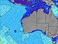 |  |  |  |  |  |  | 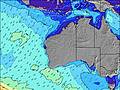 | |||||||||||||
Wave Height (m) Direction Period (s) | N 5 | WSW 16 | NNW 5 | NW 5 | W 6 | WSW 16 | WSW 15 | WSW 15 | WSW 15 | WSW 15 | WSW 14 | WSW 14 | WSW 17 | WSW 15 | WSW 14 | WSW 14 | WSW 14 | WSW 10 | SW 10 | SW 8 | W 21 |
Wave Graph | |||||||||||||||||||||
16 | 0 | 44 | 45 | 47 | 0 | 0 | 0 | 0 | 0 | 0 | 0 | 0 | 0 | 0 | 0 | 0 | 0 | 0 | 0 | 9 | |
Wind (km/h) | |||||||||||||||||||||
Wind State on-shore cross-onshore cross-shore cross-offshore off-shore glassy | cross-off | cross-off | cross | cross-on | cross-off | cross-off | cross-off | cross-off | cross-off | cross | cross-off | glassy | cross-on | cross-on | on | on | cross | cross-off | cross | cross-off | cross-off |
High Tide | 10:58AM0.54m | 4:01AM0.39m | 11:07AM0.47m | 4:09AM0.45m | 10:31AM0.39m | 4:32AM0.51m | 5:04AM0.58m | 5:45AM0.65m | 6:31AM0.71m | ||||||||||||
Low Tide | 7:09PM0.13m | 7:23PM0.16m | 6:18AM0.38m | 7:34PM0.19m | 8:44AM0.39m | 7:38PM0.21m | 6:59PM0.23m | 3:18PM0.14m | 3:41PM0.05m | ||||||||||||
— | — | 7:18 | — | — | 7:18 | — | — | 7:16 | — | — | 7:16 | — | — | 7:16 | — | — | 7:16 | — | — | 7:16 | |
5:23 | — | — | 5:23 | — | — | 5:24 | — | — | 5:24 | — | — | 5:25 | — | — | 5:25 | — | — | 5:27 | — | 5:27 | |
mm | — | — | — | — | 7 | — | — | — | — | — | — | — | — | — | — | 2 | 2 | — | — | — | 2 |
Temp °C | 17 | 16 | 15 | 19 | 16 | 14 | 18 | 16 | 14 | 16 | 16 | 14 | 16 | 16 | 17 | 17 | 17 | 14 | 16 | 16 | 14 |
Feels °C | 12 | 12 | 10 | 15 | 14 | 12 | 15 | 12 | 13 | 14 | 13 | 14 | 15 | 15 | 14 | 12 | 10 | 11 | 13 | 14 | 13 |
Swell 1 Height (m) Direction Period (s) | WSW 16 | WSW 16 | WSW 14 | WSW 15 | WSW 14 | WSW 16 | WSW 15 | WSW 15 | WSW 15 | WSW 15 | WSW 14 | WSW 14 | WSW 17 | WSW 15 | WSW 14 | WSW 14 | WSW 14 | WSW 10 | W 14 | SW 8 | WSW 13 |
1005 | 649 | 330 | 344 | 1016 | 2716 | 2691 | 2800 | 2365 | 1951 | 1257 | 943 | 2895 | 2383 | 1939 | 1633 | 953 | 782 | 250 | 313 | 640 | |
Swell 2 Height (m) Direction Period (s) | — | — | — | — | W 6 | — | — | — | — | — | — | WSW 20 | — | — | SW 4 | — | — | WSW 14 | — | WSW 13 | W 21 |
— | — | — | — | 47 | — | — | — | — | — | — | 432 | — | — | 9 | — | — | 308 | — | 282 | 9 | |
Swell 3 Height (m) Direction Period (s) | — | — | — | — | — | — | — | — | — | — | — | — | — | — | — | — | — | — | — | — | — |
— | — | — | — | — | — | — | — | — | — | — | — | — | — | — | — | — | — | — | — | — | |
Wind waves Height (m) Direction Period (s) | N 5 | N 4 | NNW 5 | NW 5 | — | — | — | — | — | — | — | — | — | — | — | — | SW 8 | S 5 | SW 10 | SE 4 | — |
16 | 19 | 44 | 45 | — | — | — | — | — | — | — | — | — | — | — | — | 622 | 50 | 708 | 6 | — | |
Nearest Offshore or Glassy | |||||||||||||||||||||
Distance (km) | 324 | 38 | 127 | 320 | 217 | 4 | 3 | 1 | 1 | 1 | 143 | 1 | 21 | 28 | 143 | 217 | 143 | 304 | 501 | 1880 | 143 |
Best forecast wave conditions in Perth City Coast | |||||||||||||||||||||
Best forecast wave conditions in Australia | |||||||||||||||||||||
Header Global | |||||||||||||||||||||
- Map Icons:
 Break
Break Live Wave Height (m)
 Live Wind Speed (km/h)
 Surf Rating (10 Max)
 Ocean Swells (m)
- Wind Speed (km/h)


FREE! Surf-Forecast.com widget for your website
The surf report / weather widget below is available to embed on third party websites free of charge and provides a summary of our Artificial reef surf forecast. Simply grab the html code snippet that we provide and paste it into your own site. You can choose your preferred language and metric/imperial units for the surf forecast feed to suit users of your site. Click here to get the code.
Information about the Artificial reef Surf forecast
The above surf forecast table for Artificial reef provides essential information for determining whether the surfing conditions will be good over the next 16 days. A general guide to surfing at Artificial reef can be found by selecting the local surf guide option on the grey menu. Our Artificial reef surf forecast is unique since it includes wave energy (power) that defines the real feel of the surf rather than just the height or the period. If you surf the same spot (Artificial reef) regularly then make a mental note of the wave energy from the surf forecast table each time you go. Very soon you may start to choose your surf days based on the wave energy alone combined with our forecast of favourable offshore wind conditions. Our star ratings will help here and of course you will also find the usual wave height and period predictions on our surf forecasts as well as a full break down of the swell components under our advanced users option (to reveal that, click the little Einstein character under the tide times).
Further information to help with frequently asked questions about our surf forecast for Artificial reef may be found under the help tab on the top menu and also by moving your mouse over the question marks on the surf forecast table itself. Please always bear in mind that the forecast is for near-shore open water and local factors at each surf break influence the actual breaking wave height, such as the beach / reef profile, water depths offshore and shelter.
Artificial reef is 5 km (3 miles) from the very large city of Fremantle. If you plan a holiday in Perth City Coast, look for hotels and other accommodation in Fremantle. Fremantle has rooms for a wide range of budgets as well as cheap car hire and transport links.
 Nearest