

Surf Forecasts:

Gunnamatta Beach surf forecast from 2 Aug 2026:
- Best quality surf: Monday 10 Aug, 7AM (local time) - 15ft (4.5m), 13s period, WSW swell with cross-shore winds.
- Most powerful swell: Monday 10 Aug, 10AM (local time) - 16ft (5.0m), 15s period, WSW swell with 10,260 kJ wave energy.
- Next surfable swell (1★+): Friday 7 Aug, 1PM (local time) - 6ft (1.8m), 16s period with SW swell.
Best Forecast Surf Conditions for Gunnamatta Beach this week:
The surf forecast for Gunnamatta Beach over the next 16 days: The first swell (rated 1 star or higher) is forecast to arrive on Friday (Aug 07) at 1PM. The primary swell is predicted to be 1.8m and 16s period with a secondary swell of 0.4m and 19s. The wind is predicted to be cross-offshore as the swell arrives.
The most powerful waves expected at Gunnamatta Beach in the next 16 days are 5.0m 15s and forecast to arrive on Monday (Aug 10) at 10AM. Winds are predicted to be cross-onshore at the time the swell arrives. The largest open ocean swell (not directed at the beach) is 1.8m 6s period and expected on Sunday (Aug 09) at 7AM.
| Wave Type | Time (AEST) & Date | Wave Height & Period |
|---|---|---|
| Next good surf (1 star+) | 1PM (Fri 7th Aug) | 6ft (1.8m) 16s |
| Best Surf | 7AM (Mon 10th Aug) | 15ft (4.5m) 13s |
| Most Powerful | 10AM (Mon 10th Aug) | 16ft (5.0m) 15s |
Table - best surf conditions forecast for Gunnamatta Beach over the next 16 days.
The Lowdown
Righto, let’s have a look at what’s on the cards for the coming weeks. We’re talking about Gunnamatta Beach, and it’s a bit of a mixed bag. The water temperature is sitting at 57°, which is pretty much average for the time of year, nothing wild there.
The first few days are a write-off, if I’m being honest. Monday and Tuesday are a mess with strong cross and onshore winds, lumpy seas, and the swell is just a confused, choppy affair. The combined energy is high, but it’s all for nothing with the wind. You’d be mad to paddle out Monday arvo – 7ft of lumpy WSW swell with fresh cross-onshore wind, just ugly. Tuesday arvo even sees a 10ft SW swell but with strong onshore winds that make it a total no-go. Wednesday and Thursday are similar – poor conditions with rain and onshore winds. There’s a solid 5ft SW groundswell on Friday morning, but it’s cross-on and marginal. Honestly, the first week is a brutal slog.
Then, out of nowhere, Friday afternoon on the 7th of August looks like a little gem. The wind swings to a light offshore from the NE, and you’ve got a clean 5ft SW swell with a long 15-second period. The combined energy is solid (1627), and the description says “excellent surf conditions for experienced surfers.” That’s your window. It’s a bit of a standout, but it’s a short-lived one.
Saturday the 8th stays clean with offshore cross-off winds, but the swell is the same 5ft, and the wind is a fresh 30 km/h from the north, which is a bit of a howler. It’s surfable, but not the same quality as Friday arvo. Sunday the 9th is a no-go with near-gale winds, despite the swell being around.
Now, the second week gets a bit wild. Monday the 10th and Tuesday the 11th see a massive jump in size – we’re talking 16ft of SW swell with combined energy hitting 12,000+. That’s way too big for Gunnamatta, even for experts. The wind is cross or cross-on, but the swell is just too much. It’s a “too big” warning. This continues into the middle of the week with 12ft to 13ft swells. It’s a real beast, but not for surfing.
The real standout for the second week is Saturday the 15th of August. The morning has a clean 7ft SW swell with a 16-second period, and a light offshore breeze from the NNW. The combined energy is 2587, and it’s marked as “excellent surf conditions for experienced surfers.” That’s your best bet for a proper session. The afternoon is still okay, but the wind goes light cross-on, so it’s a bit less clean.
So, to sum it up: the first week is mostly a dud, with a brief window Friday afternoon the 7th. The second week is dominated by a massive, dangerous swell, but the real prize is the morning of Saturday the 15th. Keep an eye on that one.
Rusty.
Short Range ForecastHeavy rain (total 28mm), heaviest during Tue morning. Very mild (max 12°C on Mon afternoon, min 8°C on Mon night). Winds decreasing (strong winds from the WSW on Tue morning, moderate winds from the W by Wed night). | Days 4-6 Weather SummaryLight rain (total 5mm), mostly falling on Sat night. Very mild (max 14°C on Fri afternoon, min 9°C on Thu morning). Winds increasing (light winds from the NE on Fri afternoon, near gales from the N by Sat night). | ||||||||||||||||||||
Monday 3 | Tuesday 4 | Wednesday 5 | Thursday 6 | Friday 7 | Saturday 8 | Sunday 9 | |||||||||||||||
AM | PM | Night | AM | PM | Night | AM | PM | Night | AM | PM | Night | AM | PM | Night | AM | PM | Night | AM | PM | Night | |
Swell Height Map |  |  |  | 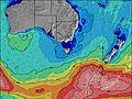 | 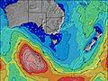 | 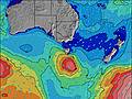 | 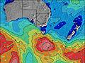 | ||||||||||||||
Wave Height (m) Direction Period (s) | SW 15 | WSW 14 | WSW 13 | SW 11 | SW 11 | SW 10 | SW 9 | SW 14 | SW 13 | SW 12 | SW 16 | SW 18 | SW 16 | SW 15 | SW 14 | SW 16 | SW 16 | SW 14 | SW 14 | SW 16 | SW 15 |
Wave Graph | |||||||||||||||||||||
1020 | 1582 | 1449 | 515 | 1970 | 753 | 297 | 1139 | 374 | 206 | 406 | 528 | 1333 | 1171 | 821 | 1240 | 1179 | 676 | 456 | 381 | 1271 | |
Wind (km/h) | |||||||||||||||||||||
Wind State on-shore cross-onshore cross-shore cross-offshore off-shore glassy | cross | cross-on | cross-on | cross | on | on | on | on | cross-on | cross | cross | cross-on | cross-on | off | cross-off | cross-off | cross-off | cross-off | cross-off | cross-off | on |
High Tide | 2:59PM1.65m | 3:14AM1.49m | 3:27PM1.65m | 3:54AM1.54m | 3:55PM1.64m | 4:35AM1.58m | 4:25PM1.62m | 5:20AM1.59m | 4:58PM1.60m | 6:09AM1.58m | 5:36PM1.57m | 7:06AM1.54m | 6:22PM1.52m | ||||||||
Low Tide | 9:15PM0.40m | 9:14AM0.38m | 9:45PM0.30m | 9:50AM0.43m | 10:17PM0.22m | 10:28AM0.49m | 10:52PM0.16m | 11:08AM0.57m | 11:33PM0.11m | 11:53AM0.66m | 00:20AM0.10m | 12:45PM0.76m | 1:16AM0.12m | ||||||||
7:20 | — | — | 7:18 | — | — | 7:18 | — | — | 7:16 | — | — | 7:16 | — | — | 7:15 | — | — | 7:13 | — | — | |
— | 5:31 | — | — | 5:32 | — | — | 5:34 | — | — | 5:35 | — | — | 5:36 | — | — | 5:37 | — | — | 5:37 | — | |
mm | 1 | — | 3 | 9 | 4 | 8 | 2 | 1 | — | — | — | — | — | — | — | — | — | 5 | 2 | 4 | 10 |
Temp °C | 11 | 12 | 10 | 12 | 12 | 12 | 12 | 12 | 12 | 9 | 12 | 12 | 12 | 14 | 13 | 13 | 14 | 13 | 11 | 10 | 12 |
Feels °C | 3 | 4 | 2 | 3 | 4 | 6 | 7 | 5 | 6 | 4 | 6 | 8 | 7 | 10 | 9 | 6 | 7 | 5 | -1 | -1 | 2 |
Swell 1 Height (m) Direction Period (s) | SW 15 | WSW 14 | SW 17 | SW 11 | — | SW 10 | SW 9 | SW 19 | SW 13 | SW 12 | SW 16 | SW 18 | SW 16 | SW 15 | SW 14 | SW 16 | SW 16 | SW 14 | SW 14 | WSW 13 | SW 15 |
1020 | 1582 | 243 | 515 | — | 602 | 297 | 339 | 374 | 178 | 406 | 528 | 1333 | 1171 | 821 | 1240 | 1179 | 676 | 456 | 299 | 1271 | |
Swell 2 Height (m) Direction Period (s) | S 14 | S 14 | — | SW 13 | — | SW 21 | SW 11 | SW 19 | SW 18 | SW 16 | SW 5 | SW 14 | SW 6 | SW 19 | SW 18 | SSW 17 | S 8 | SSW 15 | SW 18 | SW 16 | SW 20 |
37 | 36 | — | 380 | — | 153 | 153 | 284 | 194 | 206 | 16 | 305 | 38 | 441 | 516 | 55 | 5 | 21 | 112 | 381 | 338 | |
Swell 3 Height (m) Direction Period (s) | — | — | — | SW 16 | — | SW 15 | SW 19 | S 14 | SSW 17 | SW 5 | WSW 20 | S 8 | — | SW 6 | — | — | SSW 8 | — | S 18 | S 16 | SW 21 |
— | — | — | 95 | — | 78 | 236 | 4 | 29 | 13 | 38 | 1 | — | 15 | — | — | 6 | — | 6 | 21 | 17 | |
Wind waves Height (m) Direction Period (s) | WNW 4 | WSW 10 | WSW 13 | WNW 4 | SW 11 | SW 10 | — | SW 14 | SW 6 | NW 3 | W 5 | WSW 8 | — | — | — | N 3 | NNE 4 | NNE 5 | N 6 | WNW 5 | NW 5 |
34 | 880 | 1449 | 28 | 1970 | 753 | — | 1139 | 68 | 3 | 13 | 105 | — | — | — | 7 | 19 | 63 | 172 | 78 | 157 | |
Nearest Offshore or Glassy | |||||||||||||||||||||
Distance (km) | 59 | 46 | 46 | 17 | 49 | 46 | 23 | 49 | 15 | 5 | 37 | 17 | 9 | 0 | 6 | 34 | 22 | 52 | 281 | 51 | 49 |
Best forecast wave conditions in Mornington Peninsula | |||||||||||||||||||||
Best forecast wave conditions in Australia | |||||||||||||||||||||
Header Global | |||||||||||||||||||||
- Map Icons:
 Break
Break Live Wave Height (m)
 Live Wind Speed (km/h)
 Surf Rating (10 Max)
 Ocean Swells (m)
- Wind Speed (km/h)
Latest Updates


FREE! Surf-Forecast.com widget for your website
The surf report / weather widget below is available to embed on third party websites free of charge and provides a summary of our Gunnamatta Beach surf forecast. Simply grab the html code snippet that we provide and paste it into your own site. You can choose your preferred language and metric/imperial units for the surf forecast feed to suit users of your site. Click here to get the code.
Information about the Gunnamatta Beach Surf forecast
The above surf forecast table for Gunnamatta Beach provides essential information for determining whether the surfing conditions will be good over the next 16 days. A general guide to surfing at Gunnamatta Beach can be found by selecting the local surf guide option on the grey menu. Our Gunnamatta Beach surf forecast is unique since it includes wave energy (power) that defines the real feel of the surf rather than just the height or the period. If you surf the same spot (Gunnamatta Beach) regularly then make a mental note of the wave energy from the surf forecast table each time you go. Very soon you may start to choose your surf days based on the wave energy alone combined with our forecast of favourable offshore wind conditions. Our star ratings will help here and of course you will also find the usual wave height and period predictions on our surf forecasts as well as a full break down of the swell components under our advanced users option (to reveal that, click the little Einstein character under the tide times).
Further information to help with frequently asked questions about our surf forecast for Gunnamatta Beach may be found under the help tab on the top menu and also by moving your mouse over the question marks on the surf forecast table itself. Please always bear in mind that the forecast is for near-shore open water and local factors at each surf break influence the actual breaking wave height, such as the beach / reef profile, water depths offshore and shelter.
Gunnamatta Beach is 31 km (19 miles) from Mornington. If you plan a holiday in Mornington Peninsula, look for hotels and other accommodation in Mornington. Mornington has rooms for a wide range of budgets as well as car hire and transport links.
 Nearest