

Surf Forecasts:

Sleaford Bay (Wreck Beach) surf forecast from 1 Aug 2026:
- Best quality surf: Saturday 1 Aug, 3PM (local time) - 10ft (3.0m), 16s period, SW swell with cross-offshore winds.
- Most powerful swell: Friday 7 Aug, 9AM (local time) - 11ft (3.5m), 19s period, SW swell with 7,191 kJ wave energy.
- Next surfable swell (1★+): Saturday 1 Aug, 3PM (local time) - 10ft (3.0m), 16s period with SW swell.
Best Forecast Surf Conditions for Sleaford Bay (Wreck Beach) this week:
The surf forecast for Sleaford Bay (Wreck Beach) over the next 16 days: The first swell (rated 1 star or higher) is forecast to arrive on Saturday (Aug 01) at 3PM. The primary swell is predicted to be 3.0m and 16s period. The wind is predicted to be cross-offshore as the swell arrives.
The most powerful waves expected at Sleaford Bay (Wreck Beach) in the next 16 days are 3.5m 19s and forecast to arrive on Friday (Aug 07) at 9AM. Winds are predicted to be offshore at the time the swell arrives. The largest open ocean swell (not directed at the beach) is 1.6m 7s period and expected on Sunday (Aug 02) at 9AM.
| Wave Type | Time (ACST) & Date | Wave Height & Period |
|---|---|---|
| Next good surf (1 star+) | 3PM (Sat 1st Aug) | 10ft (3.0m) 16s |
| Best Surf | 3PM (Sat 1st Aug) | 10ft (3.0m) 16s |
| Most Powerful | 9AM (Fri 7th Aug) | 11ft (3.5m) 19s |
Table - best surf conditions forecast for Sleaford Bay (Wreck Beach) over the next 16 days.
The Lowdown
Gather 'round, crew. Let’s have a look at what’s coming down the line for Sleaford Bay (Wreck Beach). The water’s sitting at 59°, which is pretty much spot on average for this time of year, so no surprises there.
The big picture is a mixed bag. We’ve got a solid run of swell, but it's often too chunky for the average punter, and the wind is a real wildcard. The first few days are a bit of a write-off for clean, rideable waves, but there’s some real quality hiding in the back half of the first week and into the second.
The window opens on Saturday the 1st of August. The morning is clean with a moderate offshore breeze, but the swell is a hefty 8ft from the SW. That’s expert territory, and the combined energy is a thumping 3538 (moderate to strong). The afternoon gets bigger, hitting 10ft, and even though the wind is cross-off and clean, it’s just too much for this spot.
Sunday the 2nd is a write-off. The wind is howling from the WNW, 19 mph, and the swell is still 8ft. The combined energy is high at 2725 (moderate to strong), but the conditions are a mess. The afternoon is even worse with a strong cross-shore wind.
Monday the 3rd is a total dud. The swell is 12ft with a cross-onshore wind. Choppy and ugly. Don’t even bother.
Tuesday the 4th is the first real standout. The morning is glassy – zero wind. The swell is 8ft from the SW, but the combined energy is 2070 (moderate). It’s still big, so only for the experienced crew, but that glassy surface will make it a dream to look at. The afternoon drops to 6ft, with a light cross-off wind and a long period of 15 seconds. Clean, punchy, and much more manageable. This is the pick of the early days.
Wednesday the 5th is a nice little lull. The morning has a 4ft SW swell with a 19-second period (very long) and a light offshore wind. The combined energy is 1748 (moderate). This is groundswell, meaning long, walled-up waves. It’s a little small, but the conditions are clean and it’s a good one for the intermediates. The afternoon is similar with 5ft.
Thursday the 6th is another standout. The morning is clean with a light offshore and a 5ft SW swell. The afternoon is a dream: 7ft SW swell, 18-second period, glassy conditions. The combined energy jumps to 3008 (moderate to strong). That’s a proper session for the experienced surfer.
Friday the 7th is a big, powerful swell event. The morning sees 12ft from the SW with a 19-second period and a moderate offshore wind. The combined energy is a massive 9587 (strong). The afternoon is 10ft with a fresh offshore. This is expert-only, and the long period means it’ll be a bit straight at the beach, but it’ll be a sight to see.
Saturday the 8th and Sunday the 9th are messy. The wind is cross-off but strong, and the swell is around 7ft to 7ft. The energy is still there, but the quality is suffering. The Sunday afternoon is a washout with a strong cross-onshore.
Monday the 10th of August is a monster. The morning swell is 18ft from the WSW, with a combined energy of 21969 (very strong). The wind is cross-onshore. This is not for surfing. Kite surfers might be looking at this one.
Tuesday the 11th is another big one. 15ft to 13ft, strong offshore winds, and combined energy of 8220 and 12208. Again, strictly for the experts, and only if they’re feeling brave.
The rest of the week, from the 12th to the 15th, is a long, ugly stretch of onshore winds and big, messy swell. The 12th has near gale-force winds. The 13th and 14th are cross-onshore and choppy. The 15th is marginal at best.
Finally, on Sunday the 16th of August, we get a reward. The morning has a 6ft SW swell, a 16-second period, and a gentle offshore breeze. The combined energy is 1384 (moderate). It’s clean, it’s manageable, and it’s a great way to close out the forecast.
So, the two true standouts are the glassy afternoon of Thursday the 6th and the clean, smaller swell of Wednesday the 5th morning. The big swell days on the 7th and 10th are for the fearless, but the 4th afternoon is also a solid shout for the experienced.
Rusty.
Short Range ForecastLight rain (total 3mm), mostly falling on Sun morning. Very mild (max 15°C on Sat afternoon, min 10°C on Sat morning). Winds decreasing (fresh winds from the W on Sun afternoon, calm by Mon night). | Days 4-6 Weather SummaryMostly dry. Very mild (max 17°C on Thu afternoon, min 11°C on Tue morning). Wind will be generally light. | ||||||||||||||||||||
Saturday 1 | Sunday 2 | Monday 3 | Tuesday 4 | Wednesday 5 | Thursday 6 | Friday 7 | |||||||||||||||
AM | PM | Night | AM | PM | Night | AM | PM | Night | AM | PM | Night | AM | PM | Night | AM | PM | Night | AM | PM | Night | |
Swell Height Map | 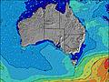 | 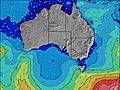 | 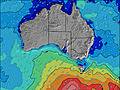 | 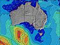 | 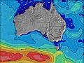 | 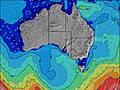 | 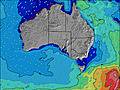 | ||||||||||||||
Wave Height (m) Direction Period (s) | SW 17 | SW 16 | SW 16 | SW 15 | SW 15 | SW 16 | SW 14 | SW 13 | SW 13 | SW 12 | SW 15 | SSW 14 | SW 19 | SW 18 | SW 16 | SW 16 | SW 18 | SW 16 | SW 19 | SW 17 | SW 16 |
Wave Graph | |||||||||||||||||||||
3538 | 4190 | 3427 | 2725 | 2233 | 6995 | 5012 | 3677 | 2088 | 1573 | 1308 | 1014 | 1066 | 1136 | 1511 | 1164 | 3001 | 4437 | 7191 | 5128 | 2974 | |
Wind (km/h) | |||||||||||||||||||||
Wind State on-shore cross-onshore cross-shore cross-offshore off-shore glassy | off | cross-off | off | cross-off | cross | cross-on | cross-on | cross-on | on | glassy | cross-off | cross-off | off | cross-off | cross-off | off | glassy | cross-off | off | off | cross-off |
High Tide | 3:44PM1.21m | 4:16AM0.82m | 4:07PM1.10m | 4:42AM0.89m | 4:28PM0.96m | 5:11AM0.94m | 4:44PM0.80m | 5:44AM0.98m | 4:45PM0.63m | 6:25AM0.98m | 3:47PM0.51m | 7:28AM0.95m | |||||||||
Low Tide | 10:24PM-0.02m | 9:56AM0.12m | 10:40PM0.00m | 10:34AM0.17m | 10:53PM0.04m | 11:16AM0.26m | 11:02PM0.08m | 12:06PM0.37m | 11:03PM0.11m | 1:36PM0.50m | 10:48PM0.12m | 10:09PM0.10m | |||||||||
7:20 | — | — | 7:20 | — | — | 7:20 | — | — | 7:18 | — | — | 7:18 | — | — | 7:16 | — | — | 7:16 | — | — | |
— | 5:45 | — | — | 5:45 | — | — | 5:45 | — | — | 5:46 | — | — | 5:47 | — | — | 5:47 | — | — | 5:49 | — | |
mm | — | — | — | 3 | — | — | — | — | — | — | — | — | — | — | — | — | — | — | — | — | — |
Temp °C | 13 | 15 | 13 | 13 | 14 | 13 | 13 | 12 | 12 | 13 | 13 | 11 | 13 | 14 | 15 | 16 | 17 | 14 | 18 | 19 | 18 |
Feels °C | 6 | 8 | 8 | 6 | 6 | 6 | 8 | 7 | 8 | 11 | 11 | 8 | 9 | 10 | 12 | 13 | 15 | 10 | 11 | 12 | 9 |
Swell 1 Height (m) Direction Period (s) | SW 17 | SW 16 | SW 16 | SW 15 | SW 15 | — | SW 14 | SW 13 | SW 13 | SW 12 | SW 15 | SSW 14 | SW 19 | SW 18 | SW 16 | SW 16 | SW 18 | SW 16 | SW 19 | SW 17 | SW 16 |
3538 | 4190 | 3427 | 2725 | 2233 | — | 5012 | 3677 | 2088 | 1573 | 1308 | 1014 | 1066 | 1136 | 1511 | 1164 | 3001 | 4437 | 7191 | 5128 | 2974 | |
Swell 2 Height (m) Direction Period (s) | — | — | — | — | WSW 20 | — | — | SSW 18 | SW 17 | SSW 15 | S 10 | SW 20 | SW 14 | SW 14 | S 7 | SW 20 | SE 7 | — | SW 14 | — | — |
— | — | — | — | 152 | — | — | 218 | 580 | 493 | 190 | 908 | 590 | 410 | 17 | 455 | 7 | — | 2390 | — | — | |
Swell 3 Height (m) Direction Period (s) | — | — | — | — | — | — | — | SW 17 | — | S 14 | SW 21 | SW 20 | S 8 | S 8 | NW 6 | SSE 7 | — | — | SSE 8 | — | — |
— | — | — | — | — | — | — | 655 | — | 4 | 210 | 653 | 92 | 48 | 9 | 10 | — | — | 6 | — | — | |
Wind waves Height (m) Direction Period (s) | NNW 4 | NW 6 | NW 7 | WNW 7 | W 6 | SW 16 | — | — | — | — | — | — | NNE 4 | — | SE 7 | — | — | E 8 | NE 4 | NNW 5 | NNE 4 |
25 | 36 | 102 | 280 | 255 | 6995 | — | — | — | — | — | — | 9 | — | 27 | — | — | 47 | 18 | 31 | 13 | |
Nearest Offshore or Glassy | |||||||||||||||||||||
Distance (km) | 0 | 107 | 163 | 755 | 755 | 837 | 401 | 827 | 110 | 0 | 0 | 34 | 0 | 0 | 0 | 0 | 0 | 109 | 163 | 163 | 279 |
Best forecast wave conditions in Eyre Peninsula | |||||||||||||||||||||
Best forecast wave conditions in Australia | |||||||||||||||||||||
Header Global | |||||||||||||||||||||
- Map Icons:
 Break
Break Live Wave Height (m)
 Live Wind Speed (km/h)
 Surf Rating (10 Max)
 Ocean Swells (m)
- Wind Speed (km/h)
Latest Updates


FREE! Surf-Forecast.com widget for your website
The surf report / weather widget below is available to embed on third party websites free of charge and provides a summary of our Sleaford Bay (Wreck Beach) surf forecast. Simply grab the html code snippet that we provide and paste it into your own site. You can choose your preferred language and metric/imperial units for the surf forecast feed to suit users of your site. Click here to get the code.
Information about the Sleaford Bay (Wreck Beach) Surf forecast
The above surf forecast table for Sleaford Bay (Wreck Beach) provides essential information for determining whether the surfing conditions will be good over the next 16 days. A general guide to surfing at Sleaford Bay (Wreck Beach) can be found by selecting the local surf guide option on the grey menu. Our Sleaford Bay (Wreck Beach) surf forecast is unique since it includes wave energy (power) that defines the real feel of the surf rather than just the height or the period. If you surf the same spot (Sleaford Bay (Wreck Beach)) regularly then make a mental note of the wave energy from the surf forecast table each time you go. Very soon you may start to choose your surf days based on the wave energy alone combined with our forecast of favourable offshore wind conditions. Our star ratings will help here and of course you will also find the usual wave height and period predictions on our surf forecasts as well as a full break down of the swell components under our advanced users option (to reveal that, click the little Einstein character under the tide times).
Further information to help with frequently asked questions about our surf forecast for Sleaford Bay (Wreck Beach) may be found under the help tab on the top menu and also by moving your mouse over the question marks on the surf forecast table itself. Please always bear in mind that the forecast is for near-shore open water and local factors at each surf break influence the actual breaking wave height, such as the beach / reef profile, water depths offshore and shelter.
Are you planning a holiday in Eyre Peninsula? If you are looking for accommodation near Sleaford Bay, camping, hotels and holiday cottages in Eyre Peninsula, consider staying in Port Lincoln which is 25 km (16 miles) away.
 Nearest