

Surf Forecasts:

State Line surf forecast from 2 Aug 2026:
- Best quality surf: Sunday 2 Aug, 2PM (local time) - 10ft (3.0m), 7s period, NW swell with cross-offshore winds.
- Most powerful swell: Saturday 8 Aug, 5PM (local time) - 11ft (3.5m), 8s period, NW swell with 1,557 kJ wave energy.
- Next surfable swell (1★+): Sunday 2 Aug, 2AM (local time) - 6ft (1.9m), 7s period with NW swell.
Best Forecast Surf Conditions for State Line this week:
The surf forecast for State Line over the next 16 days: The first swell (rated 1 star or higher) is forecast to arrive on Sunday (Aug 02) at 2AM. The primary swell is predicted to be 1.9m and 7s period with a secondary swell of 0.5m and 14s. Another secondary swell of 0.2m and 13s is also forecast. The wind is predicted to be cross-offshore as the swell arrives.
The most powerful waves expected at State Line in the next 16 days are 3.5m 8s and forecast to arrive on Saturday (Aug 08) at 5PM. Winds are predicted to be cross-shore at the time the swell arrives. The largest open ocean swell (not directed at the beach) is 3.5m 8s period and expected on Monday (Aug 03) at 5PM.
| Wave Type | Time (PDT) & Date | Wave Height & Period |
|---|---|---|
| Next good surf (1 star+) | 2AM (Sun 2nd Aug) | 6ft (1.9m) 7s |
| Best Surf | 2PM (Sun 2nd Aug) | 10ft (3.0m) 7s |
| Most Powerful | 5PM (Sat 8th Aug) | 11ft (3.5m) 8s |
Table - best surf conditions forecast for State Line over the next 16 days.
The Lowdown
Alright folks, Rusty here. Let’s be honest from the get-go: the next sixteen days at State Line are a real mixed bag, and for the most part, not a whole lot to get excited about. We’re dealing with a bit of a frustrating pattern where the swell shows up with some size, but the winds and conditions are working against us. The water temp is sitting at 56°, which is about normal for this time of year, so no surprises there.
First proper swell window to talk about arrives this Sunday, the 2nd of August. Sunday morning is a bit early with 7ft of NW swell and a 7-second period, which is short and a bit junky, but the clean sideshore-offshore breeze will at least make it surfable. The real standout, the only true highlight in this whole outlook, is Sunday afternoon. That's when it gets big, with 12ft of NW swell rolling in. The energy is substantial (1508), and the wind is clean out of the NNW. Now, let’s be straight up: 12ft is proper, expert-level territory. This is not a day for the faint of heart or a learner. The period is short at 8 seconds, so it'll be a bit of a beast and a paddle battle, but for the crew who know what they’re doing, it could be a memorable session. Expect crowds to be a factor though, as everyone will be eyeing this one.
After that, we slide into a long, dry spell. From Monday the 3rd of August all the way through to Saturday the 9th of August, the wave heights drop right off into the 1.0ft to 2ft range, and the quality is just not there. The wind stays messy or the swell is tiny with long periods that won't break properly here. It’s a proper gap with nothing worth paddling out for.
There’s another flicker of hope on Saturday the 8th of August afternoon. Just like the previous Sunday, 12ft of NW swell (1796 energy) shows up with clean wind. But again, it’s simply too big for this spot. The same goes for Thursday the 13th and Friday the 14th of August afternoons, when we see 10ft and 12ft of NW swell respectively with favorable offshore winds. It’s a cruel pattern: plenty of power, but the size is just overwhelming for State Line, making it an expert-only affair. The rest of the days in the second week are filled with tiny, weak swells and poor conditions.
So, to wrap it up: Wait for Sunday afternoon (the 2nd of August) for your one big shot, if you’ve got the skill and the nerve. It’s the standout. After that, keep your board in the car and your eyes on the forecast, because most of this run is a write-off.
Rusty
Short Range ForecastMostly dry. Warm (max 27°C on Mon afternoon, min 14°C on Sat night). Winds increasing (light winds from the N on Sat morning, strong winds from the NNW by Sun afternoon). | Days 4-6 Weather SummaryMostly dry. Warm (max 22°C on Tue afternoon, min 14°C on Thu night). Wind will be generally light. | ||||||||||||||||||||
Saturday 1 | Sunday 2 | Monday 3 | Tuesday 4 | Wednesday 5 | Thursday 6 | Friday 7 | |||||||||||||||
AM | PM | Night | AM | PM | Night | AM | PM | Night | AM | PM | Night | AM | PM | Night | AM | PM | Night | AM | PM | Night | |
Swell Height Map |  |  |  | 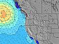 | 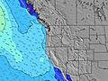 | 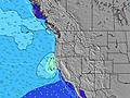 | 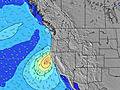 | ||||||||||||||
Wave Height (m) Direction Period (s) | WNW 8 | NW 6 | NW 7 | NW 7 | NW 8 | NW 8 | SW 13 | SW 13 | SW 16 | NW 8 | NW 8 | NW 8 | NW 8 | NW 8 | NW 8 | NW 8 | NW 8 | NW 8 | NW 8 | SSW 18 | SSW 18 |
Wave Graph | |||||||||||||||||||||
175 | 411 | 335 | 434 | 1377 | 900 | 47 | 43 | 41 | 719 | 824 | 640 | 545 | 655 | 498 | 400 | 355 | 338 | 322 | 126 | 133 | |
Wind (km/h) | |||||||||||||||||||||
Wind State on-shore cross-onshore cross-shore cross-offshore off-shore glassy | cross | cross | cross-off | cross-off | cross-off | cross-off | cross-off | cross-off | cross-off | cross | cross-on | glassy | cross-on | cross | glassy | cross-on | cross | glassy | cross | cross | glassy |
High Tide | 2:42PM1.88m | 2:08AM1.89m | 3:11PM1.95m | 2:56AM1.75m | 3:42PM2.02m | 3:53AM1.59m | 4:17PM2.08m | 5:03AM1.44m | 4:59PM2.12m | 6:30AM1.35m | 5:51PM2.16m | 8:08AM1.35m | 6:54PM2.20m | ||||||||
Low Tide | 8:11AM-0.08m | 8:27PM0.65m | 8:41AM0.06m | 9:14PM0.56m | 9:12AM0.24m | 10:07PM0.46m | 9:46AM0.46m | 11:07PM0.36m | 10:26AM0.68m | 00:14AM0.24m | 11:16AM0.88m | 1:27AM0.11m | 12:23PM1.03m | 2:38AM-0.05m | |||||||
6:09 | — | — | 6:11 | — | — | 6:11 | — | — | 6:13 | — | — | 6:13 | — | — | 6:15 | — | — | 6:16 | — | — | |
— | 8:36 | — | — | 8:34 | — | — | 8:32 | — | — | 8:31 | — | — | 8:30 | — | — | 8:30 | — | — | 8:28 | — | |
mm | — | — | — | — | — | — | — | — | — | — | — | — | — | — | — | — | — | — | — | — | — |
Temp °C | 20 | 19 | 18 | 21 | 23 | 20 | 22 | 27 | 23 | 20 | 22 | 16 | 18 | 18 | 15 | 17 | 17 | 15 | 16 | 18 | 16 |
Feels °C | 17 | 14 | 13 | 15 | 14 | 13 | 17 | 20 | 18 | 17 | 20 | 17 | 18 | 18 | 16 | 17 | 17 | 15 | 15 | 16 | 15 |
Swell 1 Height (m) Direction Period (s) | SSW 14 | SSW 14 | SW 14 | SW 14 | SSW 14 | SW 13 | SW 13 | SW 13 | NNW 8 | NW 8 | SW 15 | NW 8 | NW 8 | NW 8 | NW 8 | NW 8 | SW 13 | NW 8 | SW 13 | SW 13 | SSW 18 |
134 | 134 | 99 | 93 | 71 | 45 | 44 | 43 | 769 | 719 | 82 | 640 | 545 | 655 | 498 | 400 | 63 | 338 | 83 | 82 | 133 | |
Swell 2 Height (m) Direction Period (s) | S 13 | S 13 | S 13 | S 13 | SW 18 | SW 18 | SW 17 | SW 16 | SW 16 | SW 16 | SSW 12 | SW 15 | SW 14 | SW 14 | SW 14 | SW 14 | SW 19 | SW 13 | SW 18 | SSW 18 | SW 13 |
31 | 31 | 13 | 31 | 49 | 49 | 47 | 41 | 41 | 64 | 14 | 56 | 74 | 73 | 71 | 93 | 59 | 84 | 80 | 126 | 78 | |
Swell 3 Height (m) Direction Period (s) | SW 20 | SW 20 | WSW 19 | SW 19 | S 12 | S 12 | S 12 | S 12 | SSW 13 | SSW 12 | S 15 | SSW 12 | S 14 | S 13 | SSW 11 | SSW 20 | S 12 | SSW 19 | W 15 | S 12 | W 13 |
16 | 15 | 37 | 14 | 11 | 11 | 12 | 11 | 16 | 14 | 4 | 14 | 15 | 14 | 12 | 37 | 12 | 35 | 17 | 11 | 32 | |
Wind waves Height (m) Direction Period (s) | WNW 8 | NW 6 | NW 7 | NW 7 | NW 8 | NW 8 | NW 8 | NNW 8 | — | — | NW 8 | — | — | — | — | — | NW 8 | — | NW 8 | NNW 7 | NNW 7 |
175 | 411 | 335 | 434 | 1377 | 900 | 699 | 1703 | — | — | 824 | — | — | — | — | — | 355 | — | 322 | 586 | 342 | |
Nearest Offshore or Glassy | |||||||||||||||||||||
Distance (km) | 427 | 596 | 14 | 459 | 932 | 14 | 388 | 224 | 14 | 29 | 29 | 14 | 342 | 29 | 14 | 28 | 29 | 14 | 29 | 224 | 14 |
Best forecast wave conditions in South Oregon | |||||||||||||||||||||
Best forecast wave conditions in United States | |||||||||||||||||||||
Header Global | |||||||||||||||||||||
- Map Icons:
 Break
Break Live Wave Height (m)
 Live Wind Speed (km/h)
 Surf Rating (10 Max)
 Ocean Swells (m)
- Wind Speed (km/h)
Latest Updates


FREE! Surf-Forecast.com widget for your website
The surf report / weather widget below is available to embed on third party websites free of charge and provides a summary of our State Line surf forecast. Simply grab the html code snippet that we provide and paste it into your own site. You can choose your preferred language and metric/imperial units for the surf forecast feed to suit users of your site. Click here to get the code.
Information about the State Line Surf forecast
The above surf forecast table for State Line provides essential information for determining whether the surfing conditions will be good over the next 16 days. A general guide to surfing at State Line can be found by selecting the local surf guide option on the grey menu. Our State Line surf forecast is unique since it includes wave energy (power) that defines the real feel of the surf rather than just the height or the period. If you surf the same spot (State Line) regularly then make a mental note of the wave energy from the surf forecast table each time you go. Very soon you may start to choose your surf days based on the wave energy alone combined with our forecast of favourable offshore wind conditions. Our star ratings will help here and of course you will also find the usual wave height and period predictions on our surf forecasts as well as a full break down of the swell components under our advanced users option (to reveal that, click the little Einstein character under the tide times).
Further information to help with frequently asked questions about our surf forecast for State Line may be found under the help tab on the top menu and also by moving your mouse over the question marks on the surf forecast table itself. Please always bear in mind that the forecast is for near-shore open water and local factors at each surf break influence the actual breaking wave height, such as the beach / reef profile, water depths offshore and shelter.
Are you planning a vacation in South Oregon? If you are looking for accommodation near State Line, camping, hotels and condos and appartments in South Oregon, consider staying in Grants Pass which is 89 km (55 miles) away.
 Nearest