

Surf Forecasts:

Neakahine Point surf forecast from 3 Aug 2026:
- Best quality surf: Monday 3 Aug, 8AM (local time) - 4ft (1.2m), 8s period, WNW swell with cross-offshore winds.
- Most powerful swell: Wednesday 5 Aug, 5PM (local time) - 4.5ft (1.4m), 8s period, NW swell with 274 kJ wave energy.
- Next surfable swell (1★+): Monday 3 Aug, 8AM (local time) - 4ft (1.2m), 8s period with WNW swell.
Best Forecast Surf Conditions for Neakahine Point this week:
The surf forecast for Neakahine Point over the next 16 days: The first swell (rated 1 star or higher) is forecast to arrive on Monday (Aug 03) at 8AM. The primary swell is predicted to be 1.2m and 8s period with a secondary swell of 0.3m and 13s. The wind is predicted to be cross-offshore as the swell arrives.
The most powerful waves expected at Neakahine Point in the next 16 days are 1.4m 8s and forecast to arrive on Wednesday (Aug 05) at 5PM. Winds are predicted to be cross-onshore at the time the swell arrives. The largest open ocean swell (not directed at the beach) is 0.4m 8s period and expected on Wednesday (Aug 05) at 2PM.
| Wave Type | Time (PDT) & Date | Wave Height & Period |
|---|---|---|
| Next good surf (1 star+) | 8AM (Mon 3rd Aug) | 4ft (1.2m) 8s |
| Best Surf | 8AM (Mon 3rd Aug) | 4ft (1.2m) 8s |
| Most Powerful | 5PM (Wed 5th Aug) | 4.5ft (1.4m) 8s |
Table - best surf conditions forecast for Neakahine Point over the next 16 days.
The Lowdown
Yo, this is Rusty, and I gotta be straight with you – the outlook for Neakahine Point over the next 16 days is a tough one. We’re looking at a real dry spell, with no solid surf windows to get excited about. The forecast is packed with poor surf conditions and a whole lot of chop, so get ready for a long wait.
Alright, let’s break it down. Starting from Monday, August 3rd, right through to Sunday, August 16th, it’s a real struggle. The swell is hanging around the 3 ft to 6 ft range, mostly from the NW or WNW, but it’s a short-period, weak energy swell (mostly between 135 and 656 in the combined energy). The wind is a constant problem. We’re seeing cross-shore and cross-onshore winds, from the N, NNW, and NW, that are just ruining the surface. A few mornings, like Thursday the 6th, have a light onshore breeze, but the conditions are still labelled “marginal” at best. The water temperature is about average for this time of year, so that’s one thing not working against us.
The best of a bad bunch might be around Friday, August 14th, and Saturday, August 15th. The swell picks up a touch to 6 ft from the NW, with a combined energy hitting 656. There’s a light SW wind on the Friday morning, and a light WNW on the Saturday morning, giving us a “light cross-onshore with small wind ripples”. It’s still not clean, but it’s the best we’ll see. This spot is a reef and point break, inconsistent, and exposed to the swell. It’s an intermediate wave, but with the chop and poor conditions, it’s not worth the paddle. The crowds are “sometimes” an issue, but honestly, I don’t think many will be out.
After that, it drops off hard. By Monday, August 17th, the swell tanks to 1 ft, but the period jumps to 16 seconds from the WNW. That’s a very long period groundswell. It’s a weak, inconsistent energy (198), and the wind is light cross-onshore. For a point and reef break like Neakahine Point, that long period *could* be a positive, but the size is so small it’s barely a ripple. Then Tuesday, the 18th, brings rain showers and a 12 mph S wind, with a 2 ft, 15-second swell from the W. That’s just a mess.
So, if you’re set on Neakahine Point, the absolute best bet is the mornings of August 14th and 15th. It’s not a standout, just the least bad option. Be prepared for a long, frustrating stretch. The setup is more interesting for the kite surfers than for paddlers, to be honest.
Rusty.
Short Range ForecastMostly dry. Warm (max 25°C on Tue morning, min 12°C on Sun night). Winds decreasing (fresh winds from the N on Mon afternoon, light winds from the NE by Tue morning). | Days 5-7 Weather SummaryMostly dry. Very mild (max 18°C on Wed night, min 13°C on Thu night). Wind will be generally light. | ||||||||||||||||||
Monday 3 | Tuesday 4 | Wednesday 5 | Thursday 6 | Friday 7 | Saturday 8 | ||||||||||||||
Night | AM | PM | Night | AM | PM | Night | AM | PM | Night | AM | PM | Night | AM | PM | Night | AM | PM | Night | |
Swell Height Map |  |  |  |  | 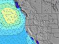 | 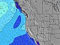 | 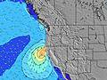 | ||||||||||||
Wave Height (m) Direction Period (s) | WNW 8 | WNW 8 | NW 7 | NW 7 | NW 7 | NW 7 | WNW 8 | WNW 8 | NW 8 | NW 8 | WNW 8 | NW 8 | NW 8 | NW 7 | NW 7 | NW 7 | NW 7 | NW 7 | NW 7 |
Wave Graph | |||||||||||||||||||
262 | 149 | 188 | 135 | 109 | 158 | 106 | 248 | 274 | 232 | 208 | 192 | 143 | 99 | 97 | 77 | 73 | 130 | 143 | |
Wind (km/h) | |||||||||||||||||||
Wind State on-shore cross-onshore cross-shore cross-offshore off-shore glassy | cross-off | cross | cross | cross-off | cross | cross | cross-off | cross-on | cross-on | cross-off | on | cross-on | cross-off | cross-on | cross | cross-off | cross-on | cross-on | cross |
High Tide | 4:12AM1.80m | 4:58PM2.08m | 5:09AM1.63m | 5:33PM2.14m | 6:19AM1.48m | 6:15PM2.19m | 7:46AM1.39m | 7:07PM2.23m | 9:24AM1.39m | 8:10PM2.27m | 10:47AM1.48m | 9:18PM2.33m | |||||||
Low Tide | 11:06PM0.42m | 11:04AM0.18m | 11:59PM0.34m | 11:38AM0.34m | 00:59AM0.27m | 12:18PM0.51m | 2:06AM0.18m | 1:08PM0.66m | 3:19AM0.08m | 2:15PM0.77m | 4:30AM-0.04m | 3:37PM0.81m | |||||||
— | 6:00 | — | — | 6:01 | — | — | 6:03 | — | — | 6:03 | — | — | 6:05 | — | — | 6:05 | — | — | |
8:43 | — | 8:42 | — | — | 8:39 | — | — | 8:38 | — | — | 8:37 | — | — | 8:36 | — | — | 8:35 | — | |
mm | — | — | — | — | — | — | — | — | — | — | — | — | — | — | — | — | — | — | — |
Temp °C | 15 | 20 | 21 | 17 | 25 | 25 | 19 | 21 | 21 | 18 | 16 | 17 | 16 | 17 | 18 | 16 | 18 | 18 | 16 |
Feels °C | 11 | 16 | 15 | 12 | 22 | 20 | 15 | 19 | 19 | 16 | 15 | 17 | 15 | 15 | 15 | 14 | 16 | 15 | 14 |
Swell 1 Height (m) Direction Period (s) | WNW 8 | WNW 8 | SW 13 | NW 7 | NW 7 | WNW 10 | NW 6 | WNW 8 | NW 8 | NW 8 | WNW 8 | NW 8 | NW 8 | NW 7 | SW 13 | NW 7 | NW 7 | WNW 11 | NW 7 |
262 | 149 | 27 | 135 | 109 | 18 | 78 | 248 | 274 | 232 | 208 | 192 | 143 | 99 | 42 | 77 | 73 | 22 | 143 | |
Swell 2 Height (m) Direction Period (s) | SW 13 | SW 13 | WSW 17 | WSW 16 | WSW 16 | WSW 16 | WNW 8 | WSW 15 | SW 14 | SW 14 | SW 14 | SW 14 | SW 13 | SW 13 | SW 18 | WNW 12 | WNW 11 | SW 12 | WNW 10 |
28 | 27 | 30 | 25 | 25 | 25 | 106 | 21 | 54 | 51 | 49 | 47 | 28 | 44 | 49 | 45 | 23 | 24 | 37 | |
Swell 3 Height (m) Direction Period (s) | WSW 18 | WSW 18 | — | SW 13 | SW 13 | SW 12 | SW 15 | SW 12 | — | S 11 | SW 11 | SW 19 | W 12 | W 15 | W 14 | SW 13 | SW 12 | SW 16 | SW 12 |
31 | 30 | — | 7 | 6 | 6 | 57 | 6 | — | 2 | 5 | 15 | 12 | 17 | 16 | 26 | 39 | 41 | 23 | |
Wind waves Height (m) Direction Period (s) | — | — | NW 7 | — | — | NW 7 | — | — | — | — | — | — | — | — | NW 7 | — | — | NW 7 | — |
— | — | 188 | — | — | 158 | — | — | — | — | — | — | — | — | 97 | — | — | 130 | — | |
Nearest Offshore or Glassy | |||||||||||||||||||
Distance (km) | 3 | 126 | 296 | 27 | 126 | 296 | 88 | 60 | 270 | 3 | 131 | 385 | 3 | 290 | 636 | 3 | 270 | 290 | 269 |
Best forecast wave conditions in North Oregon | |||||||||||||||||||
Best forecast wave conditions in United States | |||||||||||||||||||
Header Global | |||||||||||||||||||
- Map Icons:
 Break
Break Live Wave Height (m)
 Live Wind Speed (km/h)
 Surf Rating (10 Max)
 Ocean Swells (m)
- Wind Speed (km/h)
Latest Updates


FREE! Surf-Forecast.com widget for your website
The surf report / weather widget below is available to embed on third party websites free of charge and provides a summary of our Neakahine Point surf forecast. Simply grab the html code snippet that we provide and paste it into your own site. You can choose your preferred language and metric/imperial units for the surf forecast feed to suit users of your site. Click here to get the code.
Information about the Neakahine Point Surf forecast
The above surf forecast table for Neakahine Point provides essential information for determining whether the surfing conditions will be good over the next 16 days. A general guide to surfing at Neakahine Point can be found by selecting the local surf guide option on the grey menu. Our Neakahine Point surf forecast is unique since it includes wave energy (power) that defines the real feel of the surf rather than just the height or the period. If you surf the same spot (Neakahine Point) regularly then make a mental note of the wave energy from the surf forecast table each time you go. Very soon you may start to choose your surf days based on the wave energy alone combined with our forecast of favourable offshore wind conditions. Our star ratings will help here and of course you will also find the usual wave height and period predictions on our surf forecasts as well as a full break down of the swell components under our advanced users option (to reveal that, click the little Einstein character under the tide times).
Further information to help with frequently asked questions about our surf forecast for Neakahine Point may be found under the help tab on the top menu and also by moving your mouse over the question marks on the surf forecast table itself. Please always bear in mind that the forecast is for near-shore open water and local factors at each surf break influence the actual breaking wave height, such as the beach / reef profile, water depths offshore and shelter.
Neakahine Point is 51 km (32 miles) from Astoria. If you plan a vacation in North Oregon, look for hotels and other accommodation in Astoria. Astoria has rooms for a wide range of budgets as well as car hire and transport links.
 Nearest