

Surf Forecasts:

Matara surf forecast from 6 Jul 2026:
- Best quality surf: Wednesday 8 Jul, 11PM (local time) - 4ft (1.2m), 14s period, SSW swell with cross-offshore winds.
- Most powerful swell: Thursday 9 Jul, 2PM (local time) - 4.5ft (1.4m), 16s period, SSW swell with 906 kJ wave energy.
- Next surfable swell (1★+): Wednesday 8 Jul, 11PM (local time) - 4ft (1.2m), 14s period with SSW swell.
Best Forecast Surf Conditions for Matara this week:
The surf forecast for Matara over the next 16 days: The first swell (rated 1 star or higher) is forecast to arrive on Wednesday (Jul 08) at 11PM. The primary swell is predicted to be 1.2m and 14s period with a secondary swell of 0.8m and 9s. Another secondary swell of 1.5m and 10s is also forecast. The wind is predicted to be cross-offshore as the swell arrives.
The most powerful waves expected at Matara in the next 16 days are 1.4m 16s and forecast to arrive on Thursday (Jul 09) at 2PM. Winds are predicted to be cross-offshore at the time the swell arrives.
| Wave Type | Time (+0530) & Date | Wave Height & Period |
|---|---|---|
| Next good surf (1 star+) | 11PM (Wed 8th Jul) | 4ft (1.2m) 14s |
| Best Surf | 11PM (Wed 8th Jul) | 4ft (1.2m) 14s |
| Most Powerful | 2PM (Thu 9th Jul) | 4.5ft (1.4m) 16s |
Table - best surf conditions forecast for Matara over the next 16 days.
Updates in hr min s Forecast update imminent
Yo, this is Rusty. Let's get into it.
Alright, looking at the forecast for Matara, it's a bit of a mixed bag. The water is sitting at 83°, which is pretty much normal for this time of year, so no surprises there. The main issue is the wind. We've got a persistent cross-offshore breeze from the West, which is okay, but it's not the clean, glassy perfection we all dream of. It's a moderate breeze, so it'll keep the surface a bit bumpy, but not unrideable. The real kicker is the swell direction. Matara is a beach and reef setup, exposed to the swell, and it really wants waves from the Southwest to be at its best. The early part of the forecast is dominated by a West swell, which is a bit off-angle, and it's inconsistent. This means the sets will be few and far between.
The first week starts on Monday, July 6th, with a West swell around 6 ft at 10 seconds. The combined energy is moderate (923) and the cross-off wind is keeping things clean-ish, but the direction is a bit off. It's a marginal call, not really a standout. Tuesday the 7th sees similar conditions, but with a slightly longer period of 11 seconds and a bit more energy (1241), still just a 2 or 3 out of 10. The best of the early run might be Wednesday the 8th afternoon, when the swell shifts to a 5 ft SSW swell at 14 seconds, which is a better direction for Matara. The energy jumps up (1292) and the wind is still cross-off. It's a modest improvement, but still not pumping.
The real highlight, and I mean the only proper standout in this whole 16-day window, is the afternoon of Thursday, July 9th. We've got a 5 ft SSW swell with a very long period of 16 seconds. That's serious groundswell energy. The combined energy is a solid 1588, which is a nice step up. The wind is a light cross-off at 20 km/h from the West. This is your best bet. The longer period means the waves will have more shape and power, especially on a reef setup like Matara. It'll be clean, with more energy behind it. The crowds are listed as "sometimes", so you might have some company, but it's not a zoo.
After that, the swell drops off a bit. Friday the 10th afternoon has a 6 ft West swell at 11 seconds (1697 energy), but it's more of a westerly direction, which isn't ideal. The rest of the first week and into the second week sees the swell dip down to 3 ft - 4 ft, with the energy dropping. The wind stays cross-off from the West, but with the smaller swell, it's not going to be great. The period gets long again (17-19 seconds) on the 13th and 14th, but the swell height is too small to really make the most of it.
The second week is a bit of a write-off for good surf. From the 15th of July onward, the swell is small, around 3 ft, and the wind starts to go more cross-shore, creating a bit of a chop. There's a pulse of 5 ft SSW swell on the 19th, but the wind is in and out, and the energy is moderate. It's a long-range promise, but with the risk of thunderstorms and a cross-shore wind, it's not a solid bet. Overall, the best window is that Thursday afternoon, July 9th. Don't hold your breath for the rest.
Rusty, signing off.
Short Range ForecastSome drizzle, heaviest during Wed night. Warm (max 30°C on Mon morning, min 26°C on Mon night). Wind will be generally light. | Days 4-6 Weather SummaryLight rain (total 7mm), mostly falling on Thu morning. Warm (max 29°C on Thu afternoon, min 26°C on Thu night). Wind will be generally light. | ||||||||||||||||||||
Monday 6 | Tuesday 7 | Wednesday 8 | Thursday 9 | Friday 10 | Saturday 11 | Sunday 12 | |||||||||||||||
AM | PM | Night | AM | PM | Night | AM | PM | Night | AM | PM | Night | AM | PM | Night | AM | PM | Night | AM | PM | Night | |
Swell Height Map | 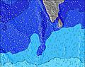 |  | 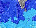 | 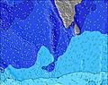 | 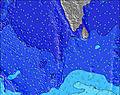 | 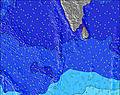 | 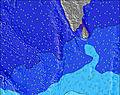 | ||||||||||||||
Wave Height (m) Direction Period (s) | W 10 | W 10 | W 10 | W 11 | W 11 | W 10 | W 10 | SSW 14 | SSW 14 | W 11 | SSW 16 | SSW 15 | SSW 14 | W 11 | SSW 14 | SSW 13 | W 11 | W 10 | W 10 | W 9 | W 9 |
Wave Graph | |||||||||||||||||||||
535 | 417 | 443 | 566 | 646 | 615 | 545 | 711 | 497 | 555 | 894 | 784 | 778 | 821 | 490 | 444 | 651 | 514 | 474 | 417 | 446 | |
Wind (km/h) | |||||||||||||||||||||
Wind State on-shore cross-onshore cross-shore cross-offshore off-shore glassy | cross-off | cross-off | cross-off | cross-off | cross-off | cross-off | cross-off | cross-off | cross-off | cross-off | cross-off | cross-off | cross-off | cross-off | cross-off | cross-off | cross-off | cross-off | cross-off | cross-off | cross-off |
High Tide | 5:48PM0.42m | 6:49AM0.44m | 6:27PM0.37m | 7:46AM0.43m | 7:21PM0.32m | 9:05AM0.43m | 9:02PM0.28m | 10:42AM0.44m | 11:27PM0.28m | 12:05PM0.46m | 00:51AM0.32m | 1:04PM0.50m | 1:44AM0.37m | ||||||||
Low Tide | 11:58AM0.17m | 00:12AM0.09m | 12:53PM0.20m | 00:49AM0.12m | 2:12PM0.22m | 1:39AM0.15m | 4:15PM0.23m | 3:00AM0.18m | 6:09PM0.19m | 4:52AM0.18m | 7:10PM0.15m | 6:19AM0.16m | 7:52PM0.11m | ||||||||
5:58 | — | — | 5:58 | — | — | 5:58 | — | — | 5:58 | — | — | 5:58 | — | — | 5:58 | — | — | 5:58 | — | — | |
— | 6:25 | — | — | 6:25 | — | — | 6:25 | — | — | 6:25 | — | — | 6:25 | — | — | 6:25 | — | — | 6:25 | — | |
mm | — | — | — | — | — | — | — | — | 1 | 1 | — | 2 | 2 | — | 1 | 1 | — | — | — | — | — |
Temp °C | 30 | 30 | 27 | 29 | 29 | 27 | 30 | 30 | 27 | 28 | 29 | 27 | 29 | 29 | 27 | 29 | 29 | 27 | 29 | 29 | 27 |
Feels °C | 30 | 29 | 28 | 29 | 28 | 29 | 30 | 30 | 30 | 29 | 30 | 30 | 30 | 29 | 30 | 29 | 29 | 30 | 29 | 28 | 29 |
Swell 1 Height (m) Direction Period (s) | SSE 10 | SSE 10 | SSE 10 | SSW 16 | SSW 15 | SSW 15 | SSW 14 | SSW 14 | SSW 14 | SSW 13 | SSW 16 | SSW 15 | SSW 14 | SSW 14 | WNW 11 | WNW 11 | SSW 13 | S 12 | S 12 | S 13 | S 12 |
143 | 140 | 135 | 392 | 279 | 279 | 465 | 711 | 497 | 321 | 894 | 784 | 778 | 778 | 383 | 356 | 367 | 309 | 304 | 414 | 446 | |
Swell 2 Height (m) Direction Period (s) | SW 16 | SW 15 | SW 15 | SSE 9 | SSE 9 | S 16 | S 15 | SSE 9 | SSE 11 | SSW 16 | SSE 9 | SSE 9 | SSE 8 | SSE 9 | SSW 14 | SSW 13 | SE 8 | SE 9 | SE 9 | SE 9 | SSW 22 |
245 | 226 | 220 | 98 | 96 | 330 | 205 | 49 | 161 | 432 | 96 | 70 | 48 | 49 | 490 | 444 | 35 | 41 | 41 | 29 | 288 | |
Swell 3 Height (m) Direction Period (s) | — | WNW 12 | S 18 | S 16 | S 17 | SSE 9 | SSE 9 | SE 9 | S 17 | SSE 10 | SW 15 | SW 15 | SSW 18 | SW 18 | SE 9 | SE 8 | S 16 | S 24 | S 15 | SW 15 | SE 9 |
— | 58 | 58 | 46 | 220 | 66 | 66 | 12 | 351 | 140 | 33 | 33 | 31 | 49 | 38 | 35 | 75 | 11 | 104 | 33 | 28 | |
Wind waves Height (m) Direction Period (s) | W 10 | W 10 | W 10 | W 11 | W 11 | W 10 | W 10 | W 10 | W 10 | W 11 | W 11 | W 11 | W 11 | W 11 | W 6 | W 6 | W 11 | W 10 | W 10 | W 9 | W 9 |
535 | 417 | 443 | 566 | 646 | 615 | 545 | 520 | 416 | 555 | 565 | 675 | 747 | 821 | 92 | 137 | 651 | 514 | 474 | 417 | 439 | |
Nearest Offshore or Glassy | |||||||||||||||||||||
Distance (km) | 152 | 893 | 177 | 169 | 176 | 176 | 128 | 128 | 128 | 169 | 176 | 177 | 176 | 785 | 387 | 176 | 391 | 177 | 176 | 391 | 177 |
Best forecast wave conditions in West Sri Lanka | |||||||||||||||||||||
Best forecast wave conditions in Sri Lanka | |||||||||||||||||||||
Header Global | |||||||||||||||||||||
- Map Icons:
 Break
Break Live Wave Height (m)
 Live Wind Speed (km/h)
 Surf Rating (10 Max)
 Ocean Swells (m)
- Wind Speed (km/h)


FREE! Surf-Forecast.com widget for your website
The surf report / weather widget below is available to embed on third party websites free of charge and provides a summary of our Matara surf forecast. Simply grab the html code snippet that we provide and paste it into your own site. You can choose your preferred language and metric/imperial units for the surf forecast feed to suit users of your site. Click here to get the code.
Information about the Matara Surf forecast
The above surf forecast table for Matara provides essential information for determining whether the surfing conditions will be good over the next 16 days. A general guide to surfing at Matara can be found by selecting the local surf guide option on the grey menu. Our Matara surf forecast is unique since it includes wave energy (power) that defines the real feel of the surf rather than just the height or the period. If you surf the same spot (Matara) regularly then make a mental note of the wave energy from the surf forecast table each time you go. Very soon you may start to choose your surf days based on the wave energy alone combined with our forecast of favourable offshore wind conditions. Our star ratings will help here and of course you will also find the usual wave height and period predictions on our surf forecasts as well as a full break down of the swell components under our advanced users option (to reveal that, click the little Einstein character under the tide times).
Further information to help with frequently asked questions about our surf forecast for Matara may be found under the help tab on the top menu and also by moving your mouse over the question marks on the surf forecast table itself. Please always bear in mind that the forecast is for near-shore open water and local factors at each surf break influence the actual breaking wave height, such as the beach / reef profile, water depths offshore and shelter.
Matara is 2 km (1 miles) from Matara. If you plan a holiday in West Sri Lanka, look for hotels and other accommodation in Matara. Matara has rooms for a wide range of budgets as well as car hire and transport links.
 Nearest