

Surf Forecasts:

Arugam Bay surf forecast from 2 Aug 2026:
- Best quality surf: Tuesday 4 Aug, 2PM (local time) - 3.5ft (1.0m), 16s period, SSW swell with glassy winds.
- Most powerful swell: Friday 7 Aug, 2AM (local time) - 6.5ft (2.0m), 16s period, SSW swell with 2,007 kJ wave energy.
- Next surfable swell (1★+): Sunday 2 Aug, 5PM (local time) - 2.5ft (0.8m), 14s period with SSW swell.
Best Forecast Surf Conditions for Arugam Bay this week:
The surf forecast for Arugam Bay over the next 16 days: The first swell (rated 1 star or higher) is forecast to arrive on Sunday (Aug 02) at 5PM. The primary swell is predicted to be 0.8m and 14s period with a secondary swell of 0.9m and 7s. The wind is predicted to be glassy as the swell arrives.
The most powerful waves expected at Arugam Bay in the next 16 days are 2.0m 16s and forecast to arrive on Friday (Aug 07) at 2AM. Winds are predicted to be cross-shore at the time the swell arrives.
| Wave Type | Time (+0530) & Date | Wave Height & Period |
|---|---|---|
| Next good surf (1 star+) | 5PM (Sun 2nd Aug) | 2.5ft (0.8m) 14s |
| Best Surf | 2PM (Tue 4th Aug) | 3.5ft (1.0m) 16s |
| Most Powerful | 2AM (Fri 7th Aug) | 6.5ft (2.0m) 16s |
Table - best surf conditions forecast for Arugam Bay over the next 16 days.
The Lowdown
G'day, this is Rusty. Let's have a look at what's on offer for Arugam Bay over the next couple of weeks.
The water's sitting at a warm 84°, which is pretty much spot on for this time of year, so no wetsuit needed, just boardshorts and wax.
We've got a bit of a slow start. Sunday the 2nd is pretty marginal, with a small 3ft swell from the SSW and a 15-second period. The wave energy is weak (334). There's a bit of a cross breeze in the morning, but by Sunday afternoon the wind goes glassy, and the swell bumps up to 3ft with a 14-second period, and the energy picks up to a moderate 475. It's a quiet start, but that glassy afternoon is a nice little window for a cruise.
Monday the 3rd is a write-off. A 6ft SSW swell with a short, weak 8-second period and strong cross-shore winds make for poor, choppy conditions. Skip it.
Tuesday the 4th is a step up. The morning is still a bit marginal with a 3ft SSW swell, but the period is a lovely long 16 seconds, and the energy is moderate (939). The real standout is Tuesday afternoon: glassy conditions, a 4ft SSW swell with that same 16-second period, and the energy is moderate (680). This is a clean, fun session for an intermediate surfer.
Now, Wednesday the 5th is the pick of the trip. The morning is absolutely glassy, with a 3ft SSW swell and a 15-second period. The energy is strong (1110). This is excellent surf for experienced surfers—clean, well-shaped waves with nice long gaps between sets. The swell direction is a bit south of the optimum SE, but with zero wind, it's going to be a gem. The afternoon is still good, but the wind picks up to a light cross, and the period jumps to a very long 20 seconds, which can make the waves break a bit straight at a point break like Arugam Bay. Still, a solid day.
Thursday the 6th and Friday the 7th keep the energy high. Thursday has a 5ft SSW swell in the morning and a 4ft in the afternoon, both with 16-18 second periods and strong energy (1591 and 1241). Winds are light cross or cross, so it's good but not perfect. Friday morning is another standout: glassy, 3ft of S swell with a 19-second period, and strong energy (1306). It's a clean, very long-period groundswell that will groom the point beautifully.
Saturday the 8th is the biggest day of the run. The morning cleans up with a 5ft S swell, 16-second period, and very strong energy (1744). The wind is a light cross-offshore, making it excellent for experienced surfers. The afternoon swell pushes to 5ft with a 17-second period and very strong energy (1992), but the wind swings cross-on and gets choppy. The morning is the winner here.
From Sunday the 9th through to Tuesday the 12th, the surf stays in the 4ft to 5ft range, with varied wind conditions. The energy stays strong to very strong. The swell direction shifts around a bit, but it's mostly from the S or SSW. Wednesday the 12th afternoon is a nice little surprise: a 4ft SSW swell with a short 7-second period, but the wind goes cross-offshore and clean, and the energy is moderate (556). It's a fun, if a bit weak, session.
The second week cools off. The swell drops to 3ft to 4ft, and the energy is moderate to weak. The best windows are Thursday the 13th afternoon (3ft SSE swell, 11-second period, light cross-offshore, moderate energy of 745) and Friday the 14th morning (3ft SSE swell, 18-second period, strong energy of 1028, but with a onshore wind).
From Friday the 14th afternoon all the way through Sunday the 17th, it's pretty grim. The swell is small, the wind is a strong cross-on from the SSW, and the energy is moderate to strong. The conditions are poor, with choppy and lumpy surf. It's more of a windsurf or kite session than a paddle session if you're keen.
Overall, the standout is Wednesday the 5th morning: glassy, 3ft SSW swell, 15-second period, strong energy (1110), and excellent for experienced surfers. The second standout is Saturday the 8th morning: 5ft S swell, 16-second period, very strong energy (1744), and clean from a light cross-offshore wind. The crowds at Arugam Bay can be a factor sometimes, but on these standout days, it's worth the company.
Rusty.
Short Range ForecastHeavy rain (total 22mm), heaviest during Mon night. Warm (max 30°C on Sun morning, min 22°C on Mon night). Wind will be generally light. | Days 4-6 Weather SummaryMostly dry. Warm (max 32°C on Thu afternoon, min 26°C on Wed morning). Wind will be generally light. | ||||||||||||||||||||
Sunday 2 | Monday 3 | Tuesday 4 | Wednesday 5 | Thursday 6 | Friday 7 | Saturday 8 | |||||||||||||||
AM | PM | Night | AM | PM | Night | AM | PM | Night | AM | PM | Night | AM | PM | Night | AM | PM | Night | AM | PM | Night | |
Swell Height Map | 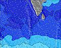 | 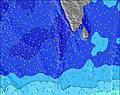 | 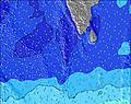 | 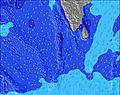 | 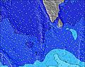 | 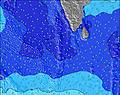 | 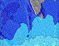 | ||||||||||||||
Wave Height (m) Direction Period (s) | SSW 15 | SSW 14 | SSW 17 | SSW 8 | SSW 8 | SSW 18 | SSW 16 | SSW 16 | SSW 15 | SSW 15 | SSW 20 | SSW 18 | SSW 18 | SSW 16 | SSW 16 | S 19 | S 18 | S 17 | S 16 | S 17 | S 16 |
Wave Graph | |||||||||||||||||||||
246 | 236 | 516 | 345 | 373 | 413 | 475 | 597 | 512 | 474 | 634 | 1062 | 1124 | 927 | 2007 | 465 | 656 | 1947 | 1193 | 1508 | 1121 | |
Wind (km/h) | |||||||||||||||||||||
Wind State on-shore cross-onshore cross-shore cross-offshore off-shore glassy | cross | glassy | cross-on | cross | cross-on | cross | cross | glassy | cross | glassy | cross | cross | cross | cross | cross | glassy | cross-on | cross | cross-off | cross-on | cross |
High Tide | 4:37PM0.14m | 6:11AM0.20m | 4:57PM0.12m | 6:22AM0.20m | 4:48PM0.10m | 6:28AM0.19m | 6:10AM0.18m | 5:03AM0.18m | 4:15AM0.18m | 1:10PM0.15m | 4:07AM0.20m | ||||||||||
Low Tide | 12:07PM0.10m | 10:57PM0.04m | 12:49PM0.10m | 10:53PM0.05m | 1:59PM0.10m | 10:18PM0.07m | 8:51PM0.07m | 8:11PM0.05m | 8:18PM0.03m | 9:45AM0.14m | 8:38PM0.02m | ||||||||||
5:56 | — | — | 5:56 | — | — | 5:56 | — | — | 5:56 | — | — | 5:56 | — | — | 5:56 | — | — | 5:56 | — | — | |
— | 6:21 | — | — | 6:21 | — | — | 6:20 | — | — | 6:20 | — | — | 6:20 | — | — | 6:20 | — | — | 6:19 | — | |
mm | — | 2 | 8 | — | 2 | 10 | — | — | — | — | — | — | — | — | — | — | — | — | — | — | — |
Temp °C | 30 | 29 | 25 | 27 | 29 | 24 | 25 | 26 | 26 | 29 | 30 | 28 | 31 | 32 | 28 | 31 | 32 | 28 | 30 | 31 | 28 |
Feels °C | 32 | 30 | 27 | 26 | 30 | 24 | 28 | 29 | 29 | 32 | 31 | 31 | 33 | 35 | 29 | 34 | 34 | 28 | 31 | 33 | 28 |
Swell 1 Height (m) Direction Period (s) | SSW 7 | SSW 7 | SSW 17 | SSW 16 | SSW 15 | SSW 18 | SSW 7 | SSW 16 | SSW 15 | SSW 15 | SSW 7 | SSW 18 | SSW 18 | SSW 16 | S 20 | S 14 | S 14 | S 17 | S 16 | S 17 | S 16 |
59 | 74 | 516 | 269 | 309 | 413 | 131 | 597 | 512 | 474 | 102 | 1062 | 1124 | 927 | 123 | 429 | 593 | 1947 | 1193 | 1508 | 1121 | |
Swell 2 Height (m) Direction Period (s) | SSW 15 | SSW 14 | SE 9 | SSW 13 | SSW 20 | SSW 14 | SSW 16 | SW 7 | S 14 | SSW 7 | SSW 20 | S 10 | SSW 8 | — | S 20 | S 19 | S 18 | — | — | — | — |
246 | 236 | 12 | 99 | 75 | 156 | 475 | 63 | 4 | 70 | 634 | 104 | 181 | — | 200 | 465 | 656 | — | — | — | — | |
Swell 3 Height (m) Direction Period (s) | SE 9 | S 18 | — | ESE 9 | SE 9 | SE 9 | SSW 13 | S 8 | S 14 | S 21 | SSW 15 | SE 9 | — | — | — | S 11 | — | — | — | — | — |
29 | 165 | — | 8 | 3 | 3 | 99 | 20 | 4 | 326 | 387 | 3 | — | — | — | 144 | — | — | — | — | — | |
Wind waves Height (m) Direction Period (s) | — | — | SW 6 | SSW 8 | SSW 8 | SSW 8 | SW 7 | — | SSW 6 | SW 7 | SW 7 | SW 6 | SSW 7 | SSW 7 | SSW 16 | SSW 7 | SSW 7 | SSW 6 | SSW 11 | SSW 7 | SSW 7 |
— | — | 147 | 345 | 373 | 193 | 234 | — | 60 | 240 | 284 | 85 | 286 | 314 | 2007 | 268 | 394 | 209 | 551 | 484 | 316 | |
Nearest Offshore or Glassy | |||||||||||||||||||||
Distance (km) | 53 | 0 | 448 | 7 | 1064 | 7 | 4 | 0 | 4 | 0 | 27 | 7 | 4 | 4 | 7 | 0 | 5 | 5 | 0 | 5 | 7 |
Best forecast wave conditions in East Sri Lanka | |||||||||||||||||||||
Best forecast wave conditions in Sri Lanka | |||||||||||||||||||||
Header Global | |||||||||||||||||||||
- Map Icons:
 Break
Break Live Wave Height (m)
 Live Wind Speed (km/h)
 Surf Rating (10 Max)
 Ocean Swells (m)
- Wind Speed (km/h)
Latest Updates


FREE! Surf-Forecast.com widget for your website
The surf report / weather widget below is available to embed on third party websites free of charge and provides a summary of our Arugam Bay surf forecast. Simply grab the html code snippet that we provide and paste it into your own site. You can choose your preferred language and metric/imperial units for the surf forecast feed to suit users of your site. Click here to get the code.
Information about the Arugam Bay Surf forecast
The above surf forecast table for Arugam Bay provides essential information for determining whether the surfing conditions will be good over the next 16 days. A general guide to surfing at Arugam Bay can be found by selecting the local surf guide option on the grey menu. Our Arugam Bay surf forecast is unique since it includes wave energy (power) that defines the real feel of the surf rather than just the height or the period. If you surf the same spot (Arugam Bay) regularly then make a mental note of the wave energy from the surf forecast table each time you go. Very soon you may start to choose your surf days based on the wave energy alone combined with our forecast of favourable offshore wind conditions. Our star ratings will help here and of course you will also find the usual wave height and period predictions on our surf forecasts as well as a full break down of the swell components under our advanced users option (to reveal that, click the little Einstein character under the tide times).
Further information to help with frequently asked questions about our surf forecast for Arugam Bay may be found under the help tab on the top menu and also by moving your mouse over the question marks on the surf forecast table itself. Please always bear in mind that the forecast is for near-shore open water and local factors at each surf break influence the actual breaking wave height, such as the beach / reef profile, water depths offshore and shelter.
Are you planning a holiday in East Sri Lanka? If you are looking for accommodation near Arugam Bay, camping, hotels and holiday cottages in East Sri Lanka, consider staying in Ampara which is 53 km (33 miles) away. Other places in and around East Sri Lanka where you can find information about places to rent, and car hire include Kalmunai which is 64 km (40 miles) away, Badulla and Batticaloa.
 Nearest