

Surf Forecasts:

How big are the waves at Matara today (14 Jul):
- Morning surf: Morning surf (14 Jul, local time) - 3ft (0.9m), 18s period with SSW swell.
- Afternoon surf: Afternoon surf (14 Jul, local time) - 3ft (0.9m), 17s period with SSW swell.
- Evening surf: Evening surf (14 Jul, local time) - 3ft (0.9m), 16s period with SSW swell.
The current surf forecast for Matara at 11AM is: 0.9m 18s primary swell from a South-southwest direction and 1.3m 11s secondary swell from a South direction, 1.5m 6s secondary swell from a West direction (forecast issued at 04:30am July 14). The wind direction is predicted to be cross-offshore.
| Time (+0530) & Date | Wave Height | Wave Period |
|---|---|---|
| Morning (14 Jul) | 3ft (0.9m) | 18s |
| Afternoon (14 Jul) | 3ft (0.9m) | 17s |
| Evening (14 Jul) | 3ft (0.9m) | 16s |
Table - waves today at Matara. (Swell directed towards the surf break)
Short Range ForecastMostly dry. Warm (max 29°C on Tue morning, min 25°C on Thu night). Wind will be generally light. | ||||||||||||||||||||||||
Tuesday 14 | Wednesday 15 | Thursday 16 | ||||||||||||||||||||||
2 AM | 5 AM | 8 AM | 11 AM | 2 PM | 5 PM | 8 PM | 11 PM | 2 AM | 5 AM | 8 AM | 11 AM | 2 PM | 5 PM | 8 PM | 11 PM | 2 AM | 5 AM | 8 AM | 11 AM | 2 PM | 5 PM | 8 PM | 11 PM | |
Swell Height Map |  | 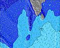 | 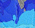 | 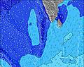 | 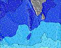 | 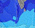 | 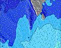 | 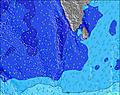 | 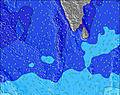 | |||||||||||||||
Wave Height (m) Direction Period (s) | S 12 | SSW 18 | SSW 18 | SSW 18 | SSW 17 | SSW 16 | SSW 16 | SSW 16 | SSW 16 | SSW 16 | SSW 16 | SSW 15 | SSW 15 | SSW 15 | SSW 15 | SSW 16 | SSW 16 | SW 15 | SW 15 | SW 14 | SW 14 | SW 14 | SW 15 | SW 15 |
Wave Graph | ||||||||||||||||||||||||
464 | 454 | 443 | 438 | 348 | 427 | 412 | 407 | 402 | 397 | 382 | 398 | 393 | 468 | 480 | 506 | 425 | 509 | 489 | 482 | 482 | 482 | 489 | 489 | |
Wind (km/h) | ||||||||||||||||||||||||
Wind State on-shore cross-onshore cross-shore cross-offshore off-shore glassy | cross-off | cross-off | cross-off | cross-off | cross-off | cross-off | cross-off | cross-off | cross-off | cross-off | cross-off | cross-off | cross-off | cross-off | cross-off | cross-off | cross-off | cross-off | cross-off | cross-off | cross-off | cross-off | cross-off | cross-off |
High Tide | 2:27AM0.41m | 2:31PM0.54m | 3:06AM0.45m | 3:06PM0.54m | 3:43AM0.48m | 3:39PM0.53m | ||||||||||||||||||
Low Tide | 8:11AM0.10m | 9:01PM0.04m | 8:54AM0.09m | 9:33PM0.02m | 9:34AM0.09m | 10:04PM0.01m | ||||||||||||||||||
— | 6:00 | — | — | — | — | — | — | — | 6:00 | — | — | — | — | — | — | — | 6:00 | — | — | — | — | — | — | |
— | — | — | — | — | 6:25 | — | — | — | — | — | — | — | 6:25 | — | — | — | — | — | — | — | 6:25 | — | — | |
mm | — | — | — | — | — | — | — | — | — | — | — | — | — | — | — | — | — | — | — | — | — | — | — | — |
Temp °C | 27 | 26 | 27 | 29 | 29 | 28 | 27 | 27 | 27 | 26 | 28 | 29 | 29 | 27 | 27 | 26 | 26 | 26 | 27 | 29 | 29 | 28 | 26 | 26 |
Feels °C | 28 | 27 | 28 | 29 | 29 | 29 | 29 | 29 | 29 | 27 | 29 | 29 | 29 | 28 | 29 | 28 | 27 | 28 | 27 | 28 | 28 | 29 | 28 | 28 |
Swell 1 Height (m) Direction Period (s) | S 12 | S 12 | S 11 | S 11 | S 11 | S 11 | S 11 | S 11 | S 11 | S 11 | S 11 | S 11 | SSW 15 | SSW 15 | SSW 15 | SSW 16 | SSW 16 | SW 15 | SW 15 | SW 14 | SW 14 | SW 14 | SW 15 | SW 15 |
464 | 441 | 354 | 408 | 348 | 292 | 292 | 282 | 287 | 237 | 235 | 235 | 393 | 468 | 480 | 506 | 425 | 509 | 489 | 482 | 482 | 482 | 489 | 489 | |
Swell 2 Height (m) Direction Period (s) | SSW 18 | SSW 18 | SSW 18 | SSW 18 | SSW 17 | SSW 16 | SSW 16 | SSW 16 | SSW 16 | SSW 16 | SSW 16 | SSW 15 | S 11 | S 11 | S 11 | S 11 | S 11 | S 10 | S 10 | S 10 | S 10 | SSE 10 | SSE 10 | SSE 10 |
377 | 454 | 443 | 438 | 336 | 427 | 412 | 407 | 402 | 397 | 382 | 398 | 191 | 191 | 188 | 188 | 227 | 218 | 216 | 208 | 204 | 170 | 167 | 163 | |
Swell 3 Height (m) Direction Period (s) | SE 8 | SE 8 | SE 8 | — | SE 8 | SSE 13 | ESE 8 | SSE 13 | ESE 8 | ESE 8 | ESE 8 | SE 8 | SE 7 | SE 9 | ESE 9 | ESE 9 | ESE 9 | ESE 9 | ESE 9 | ESE 8 | ESE 8 | ESE 8 | ESE 8 | ESE 8 |
10 | 10 | 10 | — | 10 | 33 | 6 | 16 | 6 | 6 | 6 | 2 | 2 | 3 | 8 | 8 | 8 | 8 | 7 | 7 | 7 | 7 | 7 | 6 | |
Wind waves Height (m) Direction Period (s) | W 6 | W 6 | W 6 | W 6 | W 7 | W 7 | W 7 | W 7 | W 6 | W 6 | W 6 | WSW 6 | W 6 | W 6 | W 6 | W 6 | W 6 | W 6 | W 6 | W 6 | W 6 | W 6 | W 6 | W 6 |
156 | 156 | 167 | 187 | 205 | 179 | 152 | 148 | 130 | 122 | 118 | 135 | 132 | 126 | 126 | 122 | 114 | 114 | 106 | 106 | 102 | 98 | 78 | 75 | |
Nearest Offshore or Glassy | ||||||||||||||||||||||||
Distance (km) | 177 | 387 | 387 | 674 | 800 | 177 | 795 | 177 | 177 | 177 | 391 | 744 | 893 | 811 | 785 | 177 | 177 | 177 | 177 | 176 | 785 | 785 | 391 | 177 |
Best forecast wave conditions in West Sri Lanka | ||||||||||||||||||||||||
Best forecast wave conditions in Sri Lanka | ||||||||||||||||||||||||
Header Global | ||||||||||||||||||||||||
- Map Icons:
 Break
Break Live Wave Height (m)
 Live Wind Speed (km/h)
 Surf Rating (10 Max)
 Ocean Swells (m)
- Wind Speed (km/h)


FREE! Surf-Forecast.com widget for your website
The surf report / weather widget below is available to embed on third party websites free of charge and provides a summary of our Matara surf forecast. Simply grab the html code snippet that we provide and paste it into your own site. You can choose your preferred language and metric/imperial units for the surf forecast feed to suit users of your site. Click here to get the code.
 Nearest