

Surf Forecasts:

How big are the waves at La Puntilla - Pichilemu today (28 Jul):
- Morning surf: Morning surf (28 Jul, local time) - 8ft (2.5m), 12s period with W swell.
- Afternoon surf: Afternoon surf (28 Jul, local time) - 7ft (2.1m), 11s period with W swell.
- Evening surf: Evening surf (28 Jul, local time) - 5.5ft (1.7m), 12s period with W swell.
The current surf forecast for La Puntilla - Pichilemu at 9AM is: 2.5m 12s primary swell from a West direction and 0.5m 4s secondary swell from a North direction (forecast issued at 01:00am July 28). The wind direction is predicted to be cross-onshore.
| Time (-04) & Date | Wave Height | Wave Period |
|---|---|---|
| Morning (28 Jul) | 8ft (2.5m) | 12s |
| Afternoon (28 Jul) | 7ft (2.1m) | 11s |
| Evening (28 Jul) | 5.5ft (1.7m) | 12s |
Table - waves today at La Puntilla - Pichilemu. (Swell directed towards the surf break)
Short Range ForecastHeavy rain (total 51mm), heaviest during Thu night. Very mild (max 16°C on Thu afternoon, min 12°C on Tue night). Winds increasing (calm on Tue night, strong winds from the NNE by Thu night). | ||||||||||||||||||||||||
Tuesday 28 | Wednesday 29 | Thursday 30 | ||||||||||||||||||||||
2 AM | 5 AM | 8 AM | 11 AM | 2 PM | 5 PM | 8 PM | 11 PM | 2 AM | 5 AM | 8 AM | 11 AM | 2 PM | 5 PM | 8 PM | 11 PM | 2 AM | 5 AM | 8 AM | 11 AM | 2 PM | 5 PM | 8 PM | 11 PM | |
Swell Height Map |  | 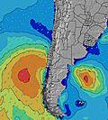 | 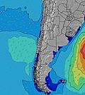 |  | 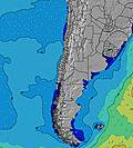 |  |  | 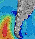 |  | |||||||||||||||
Wave Height (m) Direction Period (s) | W 13 | W 12 | W 12 | W 12 | W 11 | W 11 | W 12 | W 12 | W 12 | W 12 | W 12 | W 11 | W 11 | W 11 | W 11 | W 11 | WSW 12 | W 12 | W 12 | W 11 | W 11 | W 10 | WNW 10 | WNW 10 |
Wave Graph | ||||||||||||||||||||||||
2875 | 2300 | 1920 | 1496 | 1087 | 1004 | 872 | 702 | 617 | 607 | 456 | 357 | 344 | 284 | 235 | 188 | 228 | 228 | 396 | 606 | 918 | 1060 | 1196 | 1220 | |
Wind (km/h) | ||||||||||||||||||||||||
Wind State on-shore cross-onshore cross-shore cross-offshore off-shore glassy | cross | cross-on | cross-on | cross-on | cross-on | cross-on | cross | glassy | glassy | cross-off | cross-off | cross-off | cross | glassy | glassy | cross | cross-on | cross | cross | cross-on | cross-on | cross-on | cross-on | cross-on |
High Tide | 9:56AM1.39m | 10:27PM0.89m | 10:30AM1.43m | 10:59PM0.93m | 11:03AM1.45m | |||||||||||||||||||
Low Tide | 3:18AM0.29m | 4:42PM0.16m | 3:54AM0.24m | 5:13PM0.12m | 4:30AM0.21m | 5:43PM0.11m | ||||||||||||||||||
— | 7:43 | — | — | — | — | — | — | — | 7:43 | — | — | — | — | — | — | — | 7:41 | — | — | — | — | — | — | |
— | — | — | — | — | 6:05 | — | — | — | — | — | — | — | 6:05 | — | — | — | — | — | — | — | 6:06 | — | — | |
mm | — | — | — | — | — | — | — | — | — | — | — | — | — | — | — | — | — | — | — | — | — | — | — | 9 |
Temp °C | 13 | 13 | 13 | 14 | 14 | 14 | 12 | 12 | 12 | 12 | 12 | 14 | 15 | 14 | 14 | 14 | 13 | 12 | 13 | 15 | 16 | 15 | 16 | 14 |
Feels °C | 10 | 10 | 10 | 11 | 11 | 13 | 11 | 11 | 11 | 10 | 11 | 12 | 13 | 13 | 14 | 13 | 10 | 9 | 10 | 10 | 9 | 7 | 8 | 9 |
Swell 1 Height (m) Direction Period (s) | W 13 | W 12 | W 12 | W 12 | W 11 | W 11 | W 12 | W 12 | W 12 | W 12 | W 12 | W 11 | W 11 | W 11 | W 11 | W 11 | WSW 12 | W 12 | W 12 | W 11 | W 11 | W 10 | WNW 10 | WNW 10 |
2875 | 2300 | 1920 | 1496 | 1087 | 1004 | 872 | 702 | 617 | 607 | 456 | 357 | 344 | 284 | 235 | 188 | 228 | 228 | 396 | 606 | 918 | 1060 | 1196 | 1220 | |
Swell 2 Height (m) Direction Period (s) | SSW 10 | SSW 10 | — | SW 9 | SW 9 | SW 9 | SW 9 | SW 8 | SW 8 | SSW 8 | SW 8 | SW 8 | SW 8 | WSW 13 | WSW 13 | WSW 13 | SW 8 | SSW 8 | SSW 7 | SW 7 | — | — | N 7 | WNW 13 |
19 | 9 | — | 42 | 70 | 95 | 88 | 70 | 53 | 42 | 29 | 28 | 31 | 102 | 116 | 111 | 15 | 6 | 5 | 2 | — | — | 176 | 17 | |
Swell 3 Height (m) Direction Period (s) | — | — | — | — | WSW 13 | — | — | W 16 | WSW 16 | — | WSW 15 | WSW 15 | SW 12 | SSW 8 | SW 8 | SW 8 | NW 14 | SW 15 | SW 15 | SW 15 | — | — | WNW 13 | — |
— | — | — | — | 59 | — | — | 5 | 25 | — | 43 | 42 | 25 | 26 | 16 | 16 | 8 | 9 | 9 | 9 | — | — | 17 | — | |
Wind waves Height (m) Direction Period (s) | — | NNE 4 | N 4 | — | — | — | — | — | — | — | — | — | — | — | — | — | N 2 | N 3 | NNE 4 | N 5 | N 5 | N 6 | — | — |
— | 10 | 6 | — | — | — | — | — | — | — | — | — | — | — | — | — | 1 | 5 | 11 | 51 | 149 | 293 | — | — | |
Nearest Offshore or Glassy | ||||||||||||||||||||||||
Distance (km) | 90 | 48 | 11 | 53 | 182 | 7 | 1 | 0 | 0 | 0 | 0 | 0 | 1 | 0 | 0 | 1 | 1 | 1 | 7 | 205 | 483 | 316 | 202 | 167 |
Best forecast wave conditions in Santiago | ||||||||||||||||||||||||
Best forecast wave conditions in Chile | ||||||||||||||||||||||||
Header Global | ||||||||||||||||||||||||
- Map Icons:
 Break
Break Live Wave Height (m)
 Live Wind Speed (km/h)
 Surf Rating (10 Max)
 Ocean Swells (m)
- Wind Speed (km/h)


FREE! Surf-Forecast.com widget for your website
The surf report / weather widget below is available to embed on third party websites free of charge and provides a summary of our La Puntilla - Pichilemu surf forecast. Simply grab the html code snippet that we provide and paste it into your own site. You can choose your preferred language and metric/imperial units for the surf forecast feed to suit users of your site. Click here to get the code.
 Nearest